Inazawa, Aichi
Inazawa (稲沢市, Inazawa-shi) is a city located in Aichi Prefecture, Japan. As of 1 October 2019, the city had an estimated population of 135,580 in 54,999 households,[1] and a population density of 1,709 persons per km². The total area of the city was 79.35 square kilometres (30.64 sq mi).
Inazawa 稲沢市 | |
|---|---|
  Upper stage:Owari ōkunitama-jinja Lower stage:Inazawa Skyline | |
 Flag  Seal | |
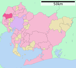 Location of Inazawa in Aichi Prefecture | |
 Inazawa | |
| Coordinates: 35°15′53″N 136°47′48.9″E | |
| Country | Japan |
| Region | Chūbu (Tōkai) |
| Prefecture | Aichi |
| Government | |
| • Mayor | Toshiaki Ōno |
| Area | |
| • Total | 79.35 km2 (30.64 sq mi) |
| Population (October 1, 2019) | |
| • Total | 135,580 |
| • Density | 1,700/km2 (4,400/sq mi) |
| Time zone | UTC+9 (Japan Standard Time) |
| - Tree | Pine |
| - Flower | Chrysanthemum |
| Phone number | 0587-32-1111 |
| Address | 1 Inabuchō, Inazawa-shi, Aichi-ken 492-8269 |
| Website | Official website |

Geography
Inazawa is located in the flatlands of far western Aichi Prefecture, bordering Gifu Prefecture on the west. Both the Kiso River and the Gojō River flow through the city.
Surrounding municipalities
- Aichi Prefecture
- Ichinomiya
- Aisai
- Kiyosu
- Ama
- Gifu Prefecture
- Hashima
- Kaizu
History
Inazawa is the location of the Nara period provincial capital and provincial temple of Owari Province. The Owari Onkunitama Jinja, an important Shinto shrine located within the borders of the present city, also dates from this period. During the Edo period, Inaba and Ozawa villages formed a post town on the Minoji, a kaidō connecting Miya-juku (Atsuta on the Tōkaidō to Tarui-juku (Mino Province) on the Nakasendō. In the early Meiji period establishment of the modern municipalities system, the town of Inazawa was created. The area of the town was expanded in 1907 and 1955 through the annexation of neighboring villages, and on November 1, 1958, the Inazawa was elevated to city status.
On April 1, 2005, the towns of Heiwa and Sobue (both from Nakashima District) were merged into Inazawa.
Demographics
Per Japanese census data,[2] the population of Inazawa has been relatively steady over the past 30 years.
| Historical population | ||
|---|---|---|
| Year | Pop. | ±% |
| 1940 | 56,321 | — |
| 1950 | 71,370 | +26.7% |
| 1960 | 79,847 | +11.9% |
| 1970 | 110,629 | +38.6% |
| 1980 | 126,023 | +13.9% |
| 1990 | 132,483 | +5.1% |
| 2000 | 136,928 | +3.4% |
| 2010 | 136,415 | −0.4% |
Climate
The city has a climate characterized by hot and humid summers, and relatively mild winters (Köppen climate classification Cfa). The average annual temperature in Inazawa is 15.6 °C. The average annual rainfall is 1758 mm with September as the wettest month. The temperatures are highest on average in August, at around 27.9 °C, and lowest in January, at around 4.4 °C.[3]
Government
Inazawa has a mayor-council form of government with a directly elected mayor and a unicameral city legislature of 26 members. The city contributes two members to the Aichi Prefectural Assembly. In terms of national politics, the city is part of Aichi District 9 of the lower house of the Diet of Japan.
Education
.jpg)
- University
- College
Inazawa has 23 public elementary schools and nine public junior high schools operated by the city government, and three public high schools operated by the Aichi Prefectural Board of Education. There are also one private high school. The prefecture also operates one special education school for the handicapped.
Economy
Inazawa is a regional commercial center and has traditionally been known for its production of vegetables and gingko nuts. Sony and Toyoda Gosei have large production plants in the city. Due to its transportation connections with the Nagoya metropolis, Inazawa is increasingly becoming a commuter town.
Companies headquartered in Inazawa
- Uny, supermarket chain
- Aikoku Alpha Corporation, automotive components
- Toshin Housing Company, construction
- Fujikei Kyoi, sake brewing
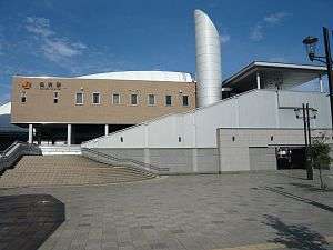
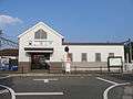
Transportation
Railways
![]()
- Ōsato – Okuda – Kōnomiya – Shima-Ujinaga
- Rokuwa – (Fuchidaka) – Marubuchi – Kami-Marubuchi – Morikami – Yamazaki
Local attractions
- Castles
- Orizu Castle
- Shobata Castle
- Shrines and Temples
- Owari Kokubun-ji
- Yawase Kannon Temple
- Owari Ōkunitama Jinja
- Natural attractions
- Sobue Dune
- Buildings and structures
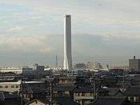
- Solae (tower) - Inazawa is the location of the Solae elevator testing tower, previously the highest such tower in the world, but now surpassed by the Kunshan Test Tower in China.[4][5]
 Shobata Castle
 Orizu Castle
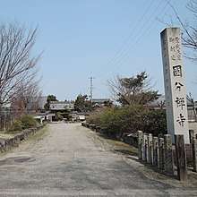 Owari Kokubun temple
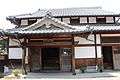 Yawase Kannon Temple
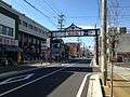 Konomiya Street
 Sobue Dune
Sister city relations


Notable people from Inazawa
- Mineo Ōsumi, admiral, Imperial Japanese Navy
- Takanori Ogisu, artist
- Seiko Niizuma, actress and singer
- Nana Seino, actress and model[9]
- Masaichi Kaneda, professional baseball player
- Junki Ito, professional baseball player
- Wataru Sakata, professional wrestler
References
- Inazawa City official statistics (in Japanese)
- Inazawa population statistics
- Inazawa climate data
- "Japan opens 'tallest lift tower'". BBC News. 3 January 2008.
- "Putting elevators to test". KONE Corporation. 17 April 2018.
- "姉妹都市:オリンピア市(ギリシャ)". 稲沢市. Archived from the original on 2011-08-08. Retrieved 2012-02-14.
- "姉妹提携情報". 自治体国際化協会. Archived from the original on 2012-10-27. Retrieved 2012-02-14.
- "International Exchange". List of Affiliation Partners within Prefectures. Council of Local Authorities for International Relations (CLAIR). Archived from the original on 24 December 2015. Retrieved 21 November 2015.
- "清野菜名". Modelpress (in Japanese). Archived from the original on August 11, 2018. Retrieved August 10, 2018.
External links
| Wikimedia Commons has media related to Inazawa, Aichi. |
- Inazawa City official website (in Japanese)
Nagoya (capital) | ||
| Wards of Nagoya | ||
| Core cities | ||
| Special cities | ||
| Cities | ||
| Districts | ||
| Authority control |
|
|---|