Tokorozawa, Saitama
Tokorozawa (所沢市, Tokorozawa-shi) is a city located in Saitama Prefecture, Japan. As of 1 February 2016, the city had an estimated population of 335,968, and a population density of 4660 persons per km². Its total area is 72.11 square kilometres (27.84 sq mi).
Tokorozawa 所沢市 | |
|---|---|
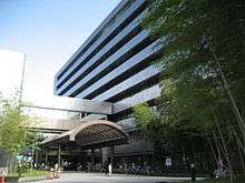
 Central Tokorozawa from Hachikokuyama | |
 Flag  Seal | |
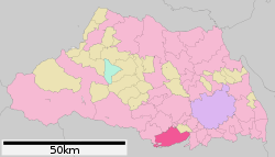 Location of Tokorozawa in Saitama Prefecture | |
 Tokorozawa Location of Tokorozawa in Saitama Prefecture | |
| Coordinates: 35°47′58.6″N 139°28′7″E | |
| Country | Japan |
| Region | Kantō |
| Prefecture | Saitama Prefecture |
| Government | |
| • Mayor | Masato Fujimoto (since October 2011) |
| Area | |
| • Total | 72.11 km2 (27.84 sq mi) |
| Population (February 2016) | |
| • Total | 335,968 |
| • Density | 4,660/km2 (12,100/sq mi) |
| Time zone | UTC+9 (Japan Standard Time) |
| - Tree | Ginkgo biloba |
| - Flower | Camellia sinensis |
| - Bird | Eurasian skylark |
| Phone number | 04-2998-1111 |
| Address | 1-1-1 Namiki, Tokorozawa-shi, Saitama-ken 359-8501 |
| Website | www.city.tokorozawa.saitama.jp |
Geography
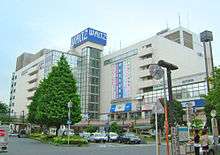
Located in the central part of the Musashino Terrace, about 30 km west of central Tokyo. Tokorozawa can be considered part of the greater Tokyo area; its proximity to the latter and lower housing costs make it a popular bedroom community. Most of Lake Sayama falls within city boundaries; Lake Tama also touches the south-western part of the city. The area around Tokorozawa Station's west exit is built up as a shopping district with several department stores. Prope Street is a popular shopping arcade.
Surrounding municipalities
- Saitama Prefecture
- Tokyo Metropolis
Climate
| Climate data for Tokorozawa (1981 - 2010) | |||||||||||||
|---|---|---|---|---|---|---|---|---|---|---|---|---|---|
| Month | Jan | Feb | Mar | Apr | May | Jun | Jul | Aug | Sep | Oct | Nov | Dec | Year |
| Record high °C (°F) | 19.0 (66.2) |
23.3 (73.9) |
26.2 (79.2) |
32.0 (89.6) |
33.8 (92.8) |
36.5 (97.7) |
39.6 (103.3) |
38.7 (101.7) |
37.4 (99.3) |
31.9 (89.4) |
25.8 (78.4) |
25.7 (78.3) |
39.6 (103.3) |
| Average high °C (°F) | 9.0 (48.2) |
9.6 (49.3) |
12.7 (54.9) |
18.5 (65.3) |
22.7 (72.9) |
25.3 (77.5) |
29.2 (84.6) |
30.9 (87.6) |
26.6 (79.9) |
21.0 (69.8) |
16.0 (60.8) |
11.6 (52.9) |
19.4 (66.9) |
| Daily mean °C (°F) | 3.6 (38.5) |
4.1 (39.4) |
7.3 (45.1) |
12.9 (55.2) |
17.3 (63.1) |
20.7 (69.3) |
24.4 (75.9) |
25.8 (78.4) |
22.0 (71.6) |
16.4 (61.5) |
10.8 (51.4) |
6.1 (43.0) |
14.3 (57.7) |
| Average low °C (°F) | −0.8 (30.6) |
−0.5 (31.1) |
2.5 (36.5) |
7.7 (45.9) |
12.8 (55.0) |
17.0 (62.6) |
20.9 (69.6) |
22.3 (72.1) |
18.7 (65.7) |
12.7 (54.9) |
6.8 (44.2) |
1.8 (35.2) |
10.1 (50.2) |
| Record low °C (°F) | −7.8 (18.0) |
−6.6 (20.1) |
−5.2 (22.6) |
−2.1 (28.2) |
4.8 (40.6) |
10.7 (51.3) |
13.6 (56.5) |
16.4 (61.5) |
9.3 (48.7) |
4.5 (40.1) |
−0.3 (31.5) |
−6.7 (19.9) |
−4.1 (24.6) |
| Average precipitation mm (inches) | 44.4 (1.75) |
48.9 (1.93) |
95.9 (3.78) |
111.5 (4.39) |
120.6 (4.75) |
157.2 (6.19) |
164.2 (6.46) |
209.7 (8.26) |
233.3 (9.19) |
173.7 (6.84) |
80.9 (3.19) |
41.3 (1.63) |
1,481.6 (58.33) |
| Average precipitation days (≥ 1.0 mm) | 3.9 | 5.5 | 9.7 | 9.6 | 10.8 | 12.8 | 12.6 | 9.8 | 12.5 | 10.3 | 6.8 | 4.4 | 108.7 |
| Mean monthly sunshine hours | 188.6 | 175.3 | 169.9 | 175.7 | 166.7 | 121.7 | 138.2 | 169.0 | 124.0 | 136.5 | 156.0 | 183.3 | 1,899.2 |
| Source 1: 気象庁 | |||||||||||||
| Source 2: 観測史上1〜10位の値(年間を通じての値) | |||||||||||||
History
Archaeological research has shown that the vicinity of Tokorozawa was settled from about 20,000 years ago.[1] Tokorozawa Shinmei Shrine has a traditional establishment of A.D. 110. Hatogamine Hachiman Shrine is believed to date from A.D. 921.
During the Kamakura period, the Kamakura Kaido ran through the area and the area was host to a series of battles fought in May 1333 that were part of the Genko War that ultimately ended the Kamakura Shogunate. These include the 1333 Battle of Kotesashi and the Battle of Kumegawa. Kotesashi was again the site of another battle nineteen years later.
During the Edo period (1603–1867) the area's major industry was silk textile production. It was also an important trading center, being located at the intersection of roads connecting Edo with the towns of Hachioji, Chichibu, Kawagoe and Fuchu.
The modern town of Tokorozawa was created within Iruma District, Saitama with the establishment of the municipalities system on April 1, 1889.
Tokorozawa became the site of Japan's first air base and air service academy in 1911. The base was used through the end of World War II and fell under the control of the United States Armed Forces after the war. The US returned most of its property in Tokorozawa to Japan in 1971, but retains a communications facility in the city which is operated by the 374th Airlift Wing of the Fifth Air Force, based at Yokota Air Base to the southwest. The facility houses antennas for communications with USAF aircraft in the region. Much of the land returned to Japan has been converted into the public Tokorozawa Aviation Memorial Park.
Tokorozawa was elevated to city status on November 3, 1950. In 1955, Tokorozawa annexed the neighboring villages of Yanase and Mikajima, and assumed its present boundaries. The development of large scale public housing and railroad development led to a rapid population increase in the 1960s. Tokorozawa was the site of the Clay pigeon shooting event in the 1964 Tokyo Olympics.[2]
Tokorozawa was designated as a special city with increased local autonomy in 2002. It currently meets the conditions to be designated as a core city but has yet to receive this designation.
Economy
Public sector
Tokorozawa houses the Tokyo Area Control Center, which controls airspace in the Kantō, Jōetsu, Tōhoku, Chūbu, and Hokuriku regions and a portion of the Kansai region.[3]
Private sector
Tokorozawa is the headquarters of Seibu Holdings, the parent company of Seibu Railway and Tokorozawa Station forms a hub in the Seibu Railway network which serves western Tokyo and southern Saitama. Tokorozawa is at the intersection of Seibu's two main lines, which respectively run to Ikebukuro Station and Seibu Shinjuku Station in central Tokyo. Several Seibu group companies, including its railway and bus divisions, are headquartered in the vicinity of Tokorozawa Station. Seibu owns an amusement park, baseball stadium (Seibu Prince Dome) and velodrome (Seibu-en Velodrome) in the "Seibu-en" district near Lake Tama in the southwestern corner of the city.
Citizen Holdings operates a watch factory in Tokorozawa.
Education
- Akikusa Gakuen Junior College
- Waseda University – Tokorozawa campus
- College of Art, Nihon University – Tokorozawa campus
- Tokorozawa has 32 elementary schools, 15 middle schools and six high schools.
Transportation
Railway

- JR East - Musashino Line
- Seibu Railway - Seibu Ikebukuro Line
- Seibu Railway - Seibu Shinjuku Line
- Seibu Railway - Seibu Sayama Line
- (entire line)
- Seibu Railway - Seibu Yamaguchi Line
- Seibu-Kyujomae Station, Yuenchi-Nishi Station
Highway
- Kan-Etsu Expressway
- Japan National Route 463
Twin towns and sister cities
Tokorozawa is twinned with:


Local attractions
Professional sports teams
- Saitama Seibu Lions (baseball, MetLife Dome)
- Saitama Broncos (basketball, Tokorozawa Municipal Stadium)
General points of interest
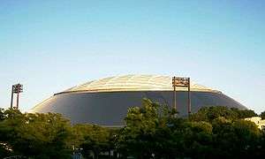

- MetLife Dome: home of the Seibu Lions
- Seibu-en: amusement park
- Sayama Ski Slope: indoor ski and snowboard resort
- Tokorozawa Aviation Museum: the location of Japan's first airfield.
- Tokorozawa Civic Cultural Centre Muse: public auditorium and concert all
- Arahata Fuji Shrine: Shinto Shrine that is a scale reproduction of Mount Fuji offering views of the latter
- Hachikokuyama: nature park famous for being the inspiration of Totoro
- Kurosuke no ie: office of Totoro fund
- Futagoyama stable: stable of professional sumo wrestlers
Historical points of interest
- Battle of Kotesashi: site of an important battle during the Genko War
- Tokorozawa Shinmei Shrine: believed to have been founded in the second century A.D.
- Shinko-ji: A Buddhist temple that was established during the Kamakura period
- Waterfall Castle: a Sengoku Period castle ruin
- Hatogamine Hachiman Shrine: an ancient Shinto shrine including a 13th-century main shrine building
- Sayama Fudōson: important temple of Tendai
- Konjoin: "Yamaguchi Kanon" Since 810-824
Events
The Tokorozawa Matsuri is a festival held each year in October and features traditional Japanese parade floats ( mikoshi ), taiko drums, and samba dancers.
A two-day festival featuring music, cultural and sports exhibitions, community group activities and food booths takes place in late October in Kokukoen Park on the grounds of the former airfield. A similar 1-day festival, the Shimin Bunka Fair, takes place in early April in the park.
The city and local business community decorates the west side of Tokorozawa station with holiday lights from early December through mid March, and separate lighting ceremonies featuring local musicians, politicians, and sports figures are conducted for various portions of the lighted areas.
Notable people from Tokorozawa
- Bokuzen Hidari (1894–1971), actor born in Kotesashi Village (which was absorbed into Tokorozawa)
- George Tokoro (Takayuki Haga), comedian
- Yoshiharu Habu, professional shogi player
- Toshiaki Kasuga, comedian
- Hokutōfuji Daiki, sumo wrestler
- Okai Chisato, former member of the idol group C-ute
- Naoto dancer, member of the groups Exile and Sandaime J Soul Brothers
Tokorozawa in popular culture
- Tokorozawa inspired the setting for the animated film My Neighbor Totoro (Tonari no Totoro).[5]
- In the light novel series Sword Art Online, much of the story is based in Tokorozawa.
- Scenes in the Japanese film Shall We Dance? were set in Tokorozawa. The Seibu Ikebukuro Line's Sayamagaoka Station features in the film.
- Scenes in the Japanese horror film Ju-on were filmed in Tokorozawa. The area around Tokorozawa Station is identifiable.
References
- ja:所沢市
- "Blame pinned on air traffic controllers," The Japan Times
- "International Exchange". List of Affiliation Partners within Prefectures. Council of Local Authorities for International Relations (CLAIR). Archived from the original on 4 January 2016. Retrieved 21 November 2015.
- Totoro
External links
| Wikimedia Commons has media related to Tokorozawa, Saitama. |
- Official Website (in Japanese)
Saitama (capital) | ||
| Wards of Saitama | ||
| Core cities | ||
| Special cities |
| |
| Cities | ||
| Districts | ||
| Authority control |
|
|---|