Ama, Aichi
Ama (あま市, Ama-shi) is a city located in Aichi Prefecture, Japan. As of 1 October 2019, the city had an estimated population of 87,651 in 36,997 households,[1] and a population density of 3,188 persons per km². The total area of the city was 27.49 square kilometres (10.61 sq mi).[2] Ama is a member of the World Health Organization’s Alliance for Healthy Cities (AFHC).[3]
Ama あま市 | |
|---|---|
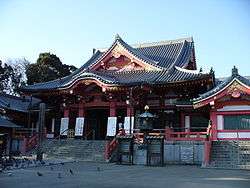 Jimoku-ji temple | |
 Flag  Emblem | |
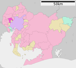 Location of Ama in Aichi Prefecture | |
 Ama | |
| Coordinates: 35°12′1.6″N 136°46′59.6″E | |
| Country | Japan |
| Region | Chūbu region Tōkai region |
| Prefecture | Aichi |
| Government | |
| • -Mayor | Koji Murakami (since April 2010) |
| Area | |
| • Total | 27.49 km2 (10.61 sq mi) |
| Population (October 1, 2019) | |
| • Total | 87,651 |
| • Density | 3,200/km2 (8,300/sq mi) |
| Time zone | UTC+9 (Japan Standard Time) |
| - Tree | Flowering dogwood |
| - Flower | Lilium |
| Phone number | 0568-28-0001 |
| Address | 18-1 Tsuchinotoi, Ama-shi, Aichi-ken 490-1291 |
| Website | Official website |


Geography
Ama is located in the far west of Aichi Prefecture in the middle of the Nōbi Plain. The city it at or below sea level.[2] Ama is located 15 minutes from downtown Nagoya by car or train.
Neighboring municipalities
- Aichi Prefecture
- Nagoya – Nakagawa-ku, Nakamura-ku
- Inazawa
- Kiyosu
- Tsushima
- Aisai
- Kanie
- Ōharu
Demographics
Per Japanese census data,[4] the population of Ama has been increasing rapidly over the past 50 years.
| Historical population | ||
|---|---|---|
| Year | Pop. | ±% |
| 1950 | 24,260 | — |
| 1960 | 25,229 | +4.0% |
| 1970 | 48,854 | +93.6% |
| 1980 | 70,190 | +43.7% |
| 1990 | 76,659 | +9.2% |
| 2000 | 82,321 | +7.4% |
| 2010 | 86,608 | +5.2% |
Climate
The city has a climate characterized by hot and humid summers, and relatively mild winters (Köppen climate classification Cfa). The average annual temperature in Ama is 15.7 °C. The average annual rainfall is 1699 mm with September as the wettest month. The temperatures are highest on average in August, at around 28.0 °C, and lowest in January, at around 4.4 °C.[5]
History
Ama was part of the former Owari Province, and has been inhabited continuously since the Jomon period. The temple of Jimoku-ji was founded in the Asuka period by Empress Suiko. From the Kamakura period, it was a shukuba on the Kamakura Kaidō. During the Sengoku period, it was the home of the daimyō Hachisuka Masakatsu, whose clan ruled from Hachitsuka Castle. It was also the birthplace of Fukushima Masanori, another Sengoku-period warlord. During the Edo period, it formed part of the holdings of the Owari Tokugawa of Owari Domain. From the Edo period, the area was known as a center for Cloisonné production. During the early Meiji period, the area was organized into several villages under Ama District, Aichi Prefecture with the establishment of the modern municipalities system. Jimokuji, was elevated to town status in 1933, Miwa in 1958 and Shippō in 1966. The three towns, plus the town of Ōharu began merger discussions in 2008; however, an agreement could not be made with Ōharu, which left the discussions later that year. The remaining three towns passed a referendum in 2009, and the new city of Ama was created on March 22, 2010.[2]
Government
Ama has a mayor-council form of government with a directly elected mayor and a unicameral city legislature of 22 members. The city contributes two members to the Aichi Prefectural Assembly. In terms of national politics, the city is part of Aichi District 9 of the lower house of the Diet of Japan.
Economy
Due to its proximity to the Nagoya metropolis, Ama has developed into a commuter town and its population has grown rapidly.
Education
Ama has twelve public elementary schools and five public middle schools operated by the city government and two public high schools operated by the Aichi Prefectural Board of Education.
Transportation
Highway
.png)
.png)

Local attractions
- Shippo Art Village
- Site of Hachitsuka Castle
- Jimoku-ji, Buddhist temple from the Asuka period
Notable people from Ama
- Noboru Ogasawara, physician
- Nobutaka Hirano, volleyball player
- Junichi Sato, anime director
References
- Ama City official statistics (in Japanese)
- Ama City official home page (in Japanese)
- Alliance for Healthy Cities official home page
- Ama population statistics
- Ama climate data
External links
| Wikimedia Commons has media related to Ama, Aichi. |
- Official website

Nagoya (capital) | ||
| Wards of Nagoya | ||
| Core cities | ||
| Special cities | ||
| Cities | ||
| Districts | ||
| Authority control |
|---|