Massachusetts Route 123
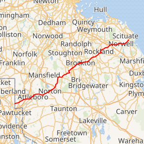
Route 123 is a 41.91-mile-long (67.45 km) west–east state highway in southeastern Massachusetts. It crosses northern Bristol and Plymouth counties, crossing several highways along the way.
| ||||
|---|---|---|---|---|
Route 123 highlighted in red | ||||
| Route information | ||||
| Maintained by MassDOT | ||||
| Length | 41.91 mi[1] (67.45 km) | |||
| Major junctions | ||||
| West end | ||||
| East end | ||||
| Location | ||||
| Counties | Bristol, Plymouth | |||
| Highway system | ||||
| ||||

Route description
Bristol County
Route 123 is a continuation of R.I. Route 123, which crosses the state line between Cumberland, Rhode Island and Attleboro. In the South Attleboro section of the city, it crosses Routes 1 and 1A in quick succession, just south of the junction of the two and the start of the Attleboro-North Attleborough retail area. It continues eastward, crossing I-95 at exit 3 before turning northeastward, passing Capron Park and the former Attleboro High School building (now a branch of Bristol Community College) before reaching downtown Attleboro. It crosses Route 152 and under the MBTA commuter rail tracks before making another northerly turn, this time at the end of Route 118.
From Attleboro, the route heads eastward into Norton. It crosses Route 140 at the town center, having a brief, 50-yard concurrency between the two. After passing Wheaton College, it continues through town, crossing I-495 at exit 10. The road then turns northward into Easton. In Easton, the road turns eastward again as it becomes concurrent with Route 106 for just over a mile, with Route 123 turning northeastward at the Five Corners intersection between the two routes and Bay Road. The route eventually meets Route 138, which it shares a short concurrency with before turning eastward again at Stonehill College.
Plymouth County
In Brockton, Route 123 crosses Route 24 at exit 17. The route passes the Brockton VA Medical Center, Campanelli Stadium, Brockton High School and the Brockton Fairgrounds in quick succession. At the intersection of Belmont Street and Warren Avenue, the eastbound and westbound lanes split. Eastbound, Route 123 makes a quick turn on and then off of Main Street and crosses Route 28 (North Montello Street) and under the Old Colony railroad tracks before turning left and sharing a short, one-block long concurrency between Route 123 East and Route 27, before meeting the westbound lanes at the intersection of Commercial Street and Centre Street. The westbound lanes, meanwhile only intersect Routes 27 and 28, heading straight from Centre Street, across Main Street and along the short Legion Parkway before turning south onto Warren Avenue to meet up with the main route once more. Signage in the area is poor, however; many maps point to Route 123 begin concurrent along Route 28 rather than following Commercial Street on the other side of the tracks.
Once the two lanes reconnect, they continue eastward along Centre Street, passing the Brockton Hospital before crossing the Beaver Brook into Abington. In Abington, Route 123 crosses Route 18 near the town center before making a quick turn along Washington street and turning eastward again, crossing Old Colony Line tracks once more (adjacent to the Abington MBTA station and Route 58 before heading into Rockland. In Rockland, the route shares a half-mile concurrency with Route 139 before turning northward, then eastward into the town of Hanover. In Hanover, the route crosses through the northern part of town, crossing Route 3 without junction before meeting Route 53 at the village of Assinippi, which provides access between Route 3 and Route 123 at exit 13.
Shortly after the intersection, and just south of Jacobs Pond, the route enters Norwell as Main Street, traveling through the town's Historic District and village center. Route 123 finally ends after three-quarters of a mile in the neighboring town of Scituate, at a rotary intersection with Route 3A.
Major intersections
| County | Location | mi | km | Destinations | Notes |
|---|---|---|---|---|---|
| Bristol | Attleboro | 0.00 | 0.00 | Continuation into Rhode Island | |
| 1.2 | 1.9 | Route 123 provides access between Route 1 north and Route 1A south | |||
| 1.3 | 2.1 | ||||
| 3.5 | 5.6 | ||||
| 5.6 | 9.0 | ||||
| 5.8 | 9.3 | Northern terminus of Route 118 | |||
| Norton | 11.3 | 18.2 | Brief, 50 yards (46 m) concurrency between the two routes | ||
| 13.1 | 21.1 | Exit 27 on I-495 (old exit 10) | |||
| Easton | 16.2 | 26.1 | Western end of Route 106 concurrency | ||
| 17.4 | 28.0 | Eastern end of Route 106 concurrency at Five Corners intersection | |||
| 20.1 | 32.3 | Southern end of Route 138 concurrency | |||
| 20.3 | 32.7 | Northern end of Route 138 concurrency | |||
| Plymouth | Brockton | 21.7 | 34.9 | Exit 31 on Route 24 (old exit 17) | |
| 24.2 | 38.9 | Warren Avenue | Western end of one-way pair | ||
| 24.5 | 39.4 | Western end of Route 27 concurrency (eastbound); eastbound junction with Route 28 | |||
| 24.6 | 39.6 | Eastern end of Route 27 concurrency (eastbound); wrong-way concurrency with Route 27 west begins at next block | |||
| 24.8 | 39.9 | Eastern end of wrong-way concurrency with Route 27; eastern end of one-way pair | |||
| Abington | 28.7 | 46.2 | |||
| 29.7 | 47.8 | ||||
| Rockland | 31.0 | 49.9 | Western end of Route 139 concurrency | ||
| 31.6 | 50.9 | Eastern end of Route 139 concurrency | |||
| Hanover | 35.7 | 57.5 | To Route 3 via Route 53 south | ||
| Scituate | 41.91 | 67.45 | Eastern terminus; rotary | ||
1.000 mi = 1.609 km; 1.000 km = 0.621 mi
| |||||
References
External links
