Massachusetts Route 140
Route 140 is a 107.76-mile-long (173.42 km) state highway which passes through parts of southeastern and central Massachusetts. The highway follows a southeast-northwest trajectory, running from U.S. Route 6 (US 6) in New Bedford just north of Buzzards Bay northwest to an intersection with Route 12 in Winchendon, a few miles south of the border with New Hampshire.[2]
| |||||||
|---|---|---|---|---|---|---|---|
| Alfred M. Bessette Memorial Highway | |||||||
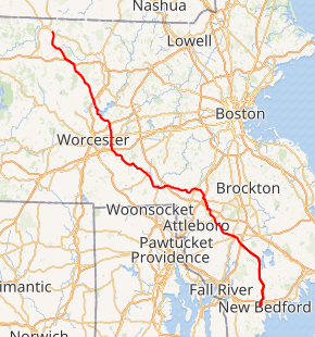
Route 140 highlighted in red | |||||||
| Route information | |||||||
| Maintained by MassDOT | |||||||
| Length | 107.76 mi[1] (173.42 km) | ||||||
| Major junctions | |||||||
| South end | |||||||
| North end | |||||||
| Location | |||||||
| Counties | Bristol, Plymouth, Norfolk, Worcester | ||||||
| Highway system | |||||||
| |||||||

The southern 19 miles (30 km) of Route 140 between New Bedford and Taunton is a freeway known as the Alfred M. Bessette Memorial Highway, or more commonly, the Taunton-New Bedford Expressway.
History

The section of modern Route 140 from West Boylston to Gardner was numbered Route 64 when it was first commissioned by 1933. By 1939, the entirety of the route was redesignated as Route 140, effectively extending existing Route 140 northwest, which had previously ended in Grafton.[3]
In 1947, the Massachusetts Department of Public Works announced plans for a "Relocated Route 140", one of the first steps as part of its statewide expressway program. Between 1955–1970 the current route was widened and straightened, while the section south of Taunton, which runs to New Bedford, was built as an expressway. The New Bedford Expressway was to serve as a spur from the Fall River Expressway, connecting to points in the Boston metropolitan area. The creation of this spur was considered a key component of revitalizing the old port city of New Bedford.[4]
Prior to the building of the freeway section, County Street (the section of road beginning at the Taunton River, and also known as County Road) brought the road southward through East Taunton, Berkley, Lakeville and East Freetown. The road, which runs parallel to the freeway and crosses it in Lakeville, merged with Route 18 in East Freetown, just north of the New Bedford city limits. The old alignment begins in front of the Silver City Galleria in Taunton.
Route description
New Bedford to Taunton
Route 140 begins at an intersection with U.S. Route 6 (Kempton Street) and Brownell Avenue in Downtown New Bedford. This intersection is signed as exit 1 when traveling southbound on Route 140. About a mile north, Route 140 comes to its first interchange, a cloverleaf with Interstate 195, which connects Providence to Cape Cod. Route 140 then curves slightly to the right to avoid New Bedford Regional Airport, which is accessible from Hathaway Road (exit 3). Route 140 eventually leaves New Bedford and enters East Freetown, providing an exit that drops off near the center of the village. Route 140 then runs parallel to Long Pond before curving slightly west. The freeway section of Route 140 ends a few miles north at exit 12, which is for Route 24. Meanwhile, Route 140 runs along County Street towards downtown Taunton.
Route 140 runs partially concurrent with Route 79 Truck in order to bypass certain sections of Route 79 proper. The two designations are concurrent from exit 10 (Route 79) to exit 12 (Route 24). At exit 12, Route 79 Truck leaves Route 140 for Route 24, where the truck route meets its parent at exit 9.
Taunton to Wrentham
From the final interchange with Route 24 in Taunton, Route 140 extends northwest towards Taunton Center, having a 0.3 mi (0.45 km) concurrency with US 44, just east of Taunton Center. As the two proceed to Taunton Green, a rotary begins with Route 140, US 44, and Route 138. Route 140 splits off from the rotary, passing the Bristol County Courthouse and heading northwest from the Green along Court Street. Route 140 brings its way through the northwest portion of Taunton, into Norton, past Wheaton College, and sharing a brief junction with MA-123. As Route 140 crosses the border from Norton to Mansfield, it passes by the Xfinity Center before reaching a junction with Interstate 495. Route 140 shares a brief stretch of highway interchange with I-495, as the route then splits off and heads north through Mansfield Center, intersecting MA-106. Route 140 crosses into Foxboro, bearing an interchange with Interstate 95, and further north a junction with US-1 North, with the US-1 South exit being another mile up the road in Wrentham. Route 140 loops through Wrentham Center, sharing a junction with Route 1A, and past King Philip Regional High School, into Franklin.
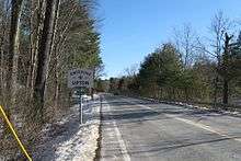
Franklin to Upton
Route 140 enters Franklin from Wrentham, passing through Franklin Center, consisting of Dean College and Franklin/Dean College Station of the Franklin Commuter Rail line. Route 140 bypasses Franklin High School, and enters its second interchange with I-495 and also the second junction of the Franklin Commuter Rail line, at Forge Park/495 station, the final stop on the line. At this point, Route 140 extends west and heads into Bellingham. Route 140 spends a brief time in Bellingham, sharing a brief concurrence with Route 126, which extends north to I-495, and south into Woonsocket, Rhode Island. As Route 140 exits Bellingham, the road sharply turns north into the eastern edges of Mendon and Hopedale for a total of nearly three miles. Route 140 then enters Milford in a northwest trajectory, staying parallel to the Milford/Hopedale border for the routes duration in Milford. Route 140 enters a junction at Milford Regional Medical Center with Route 16, which leads westbound into Mendon and Hopedale Center, and eastbound to Route 85 and Route 109, both with terminations at Route 16. Route 140 enters a final small portion of Hopedale, then proceeds into the eastern part of Upton, passing through Upton Center and bypassing both Blackstone Valley Regional Technical High School and Nipmuc Regional High School.
Grafton to West Boylston
Route 140 enters Grafton through the southeast, proceeding north and sharply turning west into Grafton Center and the town common. Route 140 bears right, northward, down a mile long hill that ends at a traffic light that begins a 1.5-mile concurrency with Route 122. Routes 140 and 122 proceed north through North Grafton, passing under the Mass Pike. Immediately after crossing under the Mass Pike, Route 122 splits off to west towards Millbury and Worcester, while Route 140 begins a concurrency with the western terminus of Route 30, and heads towards Shrewsbury. The concurrency with Route 30 is a quarter-mile long, as Route 30 splits east towards Grafton Station of the Framingham/Worcester Line MBTA Commuter Rail line, Tufts Animal Hospital, and the town of Westboro. As Route 140 enters Shrewsbury it briefly becomes an undivided, high-speed wide-median route, where it meets with U.S. 20 at an overpass. Two miles later, Route 140 meets Route 9 at an underpass. Route 9 West serves as the main road into Worcester from Shrewsbury and Northboro, while eastbound heads in the direction of Westboro and towards I-495. Route 140 extends north into Shrewsbury Center, and shares an interchange with Interstate 290 at the northern edge of town. Just north of the interchange, Route 140 enters Boylston, where it meets Route 70. After Route 70, the Wachusett Reservoir is seen, and Route 140 continues northwest into West Boylston, where in the center of town begins a brief concurrency with Route 12. The two extend north for one mile, as Route 12 splits north in the direction of Sterling and Clinton, following the western terminus of Route 110, and Route 140 extends northwest into the western portion of Sterling.
Sterling to Winchendon
As Route 140 enters Sterling, there is an interchange with Interstate 190 which serves as the main source of transportation between Worcester to the south and Fitchburg to the north. Route 140 travels northwest to an intersection with Route 62 right before entering Princeton, home to Wachusett Mountain. Route 140 then joins a concurrency with Route 31 for a mile and a half, before crossing into Westminster and next to Wachusett Lake. Route 140 then meets Routes 2 and 2A at an overpass. Routes 2 and 2A run parallel with each other between Greenfield and Boston. Route 140 joins Route 2 Westbound for one exit, leaving the highway at Exit 24B. Route 140 shortly extends into Gardner. Route 140 meets with Route 101, before extending six and a half miles into Winchendon where Route 140 ends at an intersection with Route 12. Route 12 extends northwest towards Fitzwilliam and U.S. 202, which extends south to Templeton and north to Rindge, while Route 12 moves south to Ashburnham.
Highway improvements
A section of Route 140 in Franklin was widened from two to four lanes wide. The $22 million project began in 2003 and was completed in 2007.[5]
In Fall 2013, the ramp from Route 140 to I-495 south at exit 11 in Mansfield was completed.[6] This ramp removed the need for traffic exiting the Xfinity Center in Mansfield to use a significant two-lane portion of Route 140.[7]
Major intersections
| County | Location[8] | mi[8] | km | Old exit[9] | New exit[10] | Destinations | Notes |
|---|---|---|---|---|---|---|---|
| Bristol | New Bedford | 0.0 | 0.0 | 1 | Southern terminus; at-grade intersection; continues south as Brownell Avenue | ||
| 1.2 | 1.9 | 2E-W[11] | 2A-B | Signed as exits 2A (east) and 2B (west);[10] exits 13A-B on I-195 | |||
| 1.5 | 2.4 | 3 | To New Bedford Airport | ||||
| 3.2 | 5.1 | 4 | Mount Pleasant Street / Kings Highway – Acushnet | ||||
| 5.0 | 8.0 | 5 | Phillips Road / Church Street – Freetown | ||||
| 5.7 | 9.2 | 6 | Southbound exit and northbound entrance | ||||
| 6.8 | 10.9 | 7 | Braley Road | ||||
| Freetown | 9.8 | 15.8 | 8 | 10 | Chace Road – East Freetown, Assonet | ||
| Plymouth | Lakeville | 12.2 | 19.6 | 9 | 12 | County Road – Lakeville | |
| Bristol | Taunton | 16.0 | 25.7 | 10 | 16 | ||
| 18.7 | 30.1 | 11 | 19 | Stevens Street / County Street – East Taunton | Signed as exits 11A (Stevens Street) and 11B (County Street) southbound[10] | ||
| 19.2 | 30.9 | 12 | 20 | Northern terminus of freeway, signed as exits 12A (south) and 12B (north);[10] formerly exits 12N-S[11]); exit 12 on Route 24 | |||
| 22.0 | 35.4 | Southern terminus of US 44 concurrency | |||||
| 22.3 | 35.9 | Northern terminus of US 44 concurrency | |||||
| Norton | 29.9 | 48.1 | Brief concurrency with Route 123 | ||||
| Mansfield | 33.4 | 53.8 | 11 | 30 | Southern terminus of I-495 concurrency; no direct southbound access from I-495 north | ||
| 12 | 31 | Northern terminus of I-495 concurrency | |||||
| 35.4 | 57.0 | ||||||
| Norfolk | Foxborough | 36.5 | 58.7 | Exits 7A-B on I-95 | |||
| 40.0 | 64.4 | Access via local roads | |||||
| 40.3 | 64.9 | Southern terminus of Route 115 | |||||
| Wrentham | 43.0 | 69.2 | |||||
| Franklin | 49.0 | 78.9 | Exit 17 on I-495 | ||||
| Bellingham | 51.6 | 83.0 | Southern end of concurrency with Route 126 | ||||
| Northern end of concurrency with Route 126 | |||||||
| Worcester | Milford | 56.4 | 90.8 | ||||
| Grafton | 67.8 | 109.1 | Southern terminus of Route 122 concurrency | ||||
| 69.2 | 111.4 | Northern terminus of Route 122 concurrency; western terminus of Route 30; southern terminus of Route 30 concurrency | |||||
| 69.5 | 111.8 | Northern terminus of Route 30 concurrency | |||||
| Shrewsbury | 70.892 | 114.090 | Interchange | ||||
| 72.7 | 117.0 | Access via local roads | |||||
| 75.9 | 122.1 | Exits 23A-B on I-290 | |||||
| Boylston | 77.8 | 125.2 | |||||
| West Boylston | 80.7 | 129.9 | Southern terminus of Route 12 concurrency | ||||
| 81.5 | 131.2 | Northern terminus of Route 12 concurrency | |||||
| Sterling | 83.9 | 135.0 | Exit 5 on I-190 | ||||
| 86.2 | 138.7 | ||||||
| Princeton | 89.7 | 144.4 | Southern terminus of Route 31 concurrency | ||||
| 91.4 | 147.1 | Northern terminus of Route 31 concurrency | |||||
| Westminster | 95.5 | 153.7 | 25 | Southern terminus of Route 2 concurrency | |||
| 97.5 | 156.9 | 24 | Northern terminus of Route 2 concurrency | ||||
| Gardner | 100.3 | 161.4 | |||||
| Winchendon | 107.76 | 173.42 | Northern terminus | ||||
1.000 mi = 1.609 km; 1.000 km = 0.621 mi
| |||||||
References
- Executive Office of Transportation, Office of Transportation Planning - 2005 Road Inventory
- "Massachusetts Atlas and Gazetteer." Yarmouth, Maine: DeLorme. First Edition, 1998.
- Neilbert.com Home: MA 140
- http://www.bostonroads.com/roads/MA-140/
- "Archived copy". Archived from the original on 2014-12-07. Retrieved 2014-12-05.CS1 maint: archived copy as title (link)
- "Archived copy". Archived from the original on 2014-12-07. Retrieved 2014-12-05.CS1 maint: archived copy as title (link)
- Barrett, Chris (July 9, 2010). "Mass. DOT to begin work on ramps connecting Route 140, I-495". Providence Business News. Providence, Rhode Island: Providence Business News. Retrieved April 27, 2014.
- "MassDOT Route Log Application". Massachusetts Department of Transportation. Retrieved November 21, 2019.
- "Major highway routes and exits". Massachusetts Department of Transportation. Archived from the original on October 15, 2019. Retrieved November 21, 2019.
- "Route 140 Renumbering" (PDF). Massachusetts Department of Transportation. December 5, 2019. Retrieved December 5, 2019.
- "Street Atlas of Metro Boston and Eastern Massachusetts." Bridgewater, Massachusetts: Arrow Map, Inc. 2003 Edition.