Cokedale, Colorado
The Town of Cokedale is a Statutory Town located in Las Animas County, Colorado, United States. The town population was 129 at the 2010 United States Census. Cokedale is a former coal mining town. The mine shut down in 1947. The town was 5 miles away from the epicenter of a 5.3 earthquake on August 23, 2011.
Town of Cokedale, Colorado | |
|---|---|
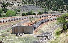
.JPG) The old Gottlieb Mercantile Building, which now houses the town hall, the post office, and the Cokedale Mining Museum. | |
 Location of Cokedale in Las Animas County, Colorado. | |
| Coordinates: 37.144223°N 104.621590°W | |
| Country | |
| State | |
| County[1] | Las Animas County |
| Incorporated | March 15, 1948[2] |
| Government | |
| • Type | Statutory Town[1] |
| Area | |
| • Total | 0.20 sq mi (0.53 km2) |
| • Land | 0.20 sq mi (0.53 km2) |
| • Water | 0.00 sq mi (0.00 km2) |
| Elevation | 6,332 ft (1,930 m) |
| Population (2010) | |
| • Total | 129 |
| • Estimate (2018)[5] | 121 |
| • Density | 575.61/sq mi (222.32/km2) |
| Time zone | UTC-7 (MST) |
| • Summer (DST) | UTC-6 (MDT) |
| ZIP Code[6] | Trinidad CO 81082 |
| Area code(s) | 719 |
| FIPS code | 08-15550 |
| GNIS feature ID | 0194669 |
Much of the town is included in the Cokedale Historic District, which is listed on the National Register of Historic Places.
Geography
Cokedale is located at 37°8′40″N 104°37′16″W (37.144508, -104.621224).[7]
According to the United States Census Bureau, the town has a total area of 0.2 square miles (0.52 km2), all of it land.
Demographics
| Historical population | |||
|---|---|---|---|
| Census | Pop. | %± | |
| 1950 | 214 | — | |
| 1960 | 219 | 2.3% | |
| 1970 | 101 | −53.9% | |
| 1980 | 90 | −10.9% | |
| 1990 | 116 | 28.9% | |
| 2000 | 139 | 19.8% | |
| 2010 | 129 | −7.2% | |
| Est. 2018 | 121 | [5] | −6.2% |
| U.S. Decennial Census[8] | |||
As of the census[9] of 2000, there were 139 people, 62 households, and 40 families residing in the town. The population density was 685.0 people per square mile (268.3/km²). There were 86 housing units at an average density of 423.8 per square mile (166.0/km²). The racial makeup of the town was 89.21% White, 0.72% Native American, 7.19% from other races, and 2.88% from two or more races. Hispanic or Latino of any race were 43.17% of the population.

There were 62 households out of which 24.2% had children under the age of 18 living with them, 54.8% were married couples living together, 4.8% had a female householder with no husband present, and 33.9% were non-families. 30.6% of all households were made up of individuals and 21.0% had someone living alone who was 65 years of age or older. The average household size was 2.24 and the average family size was 2.83.
In the town, the population was spread out with 23.0% under the age of 18, 4.3% from 18 to 24, 20.1% from 25 to 44, 30.2% from 45 to 64, and 22.3% who were 65 years of age or older. The median age was 46 years. For every 100 females, there were 107.5 males. For every 100 females age 18 and over, there were 98.1 males.
The median income for a household in the town was $23,958, and the median income for a family was $40,179. Males had a median income of $20,000 versus $26,250 for females. The per capita income for the town was $15,503. There were 7.3% of families and 6.9% of the population living below the poverty line, including 7.0% of under eighteens and 5.1% of those over 64.
See also
- Outline of Colorado
- State of Colorado
- Colorado cities and towns
- Colorado municipalities
- Colorado counties
- Colorado cities and towns
- Spanish Peaks
References
- "Active Colorado Municipalities". State of Colorado, Department of Local Affairs. Archived from the original on 2009-12-12. Retrieved 2007-09-01.
- "Colorado Municipal Incorporations". State of Colorado, Department of Personnel & Administration, Colorado State Archives. 2004-12-01. Retrieved 2007-09-02.
- "2016 U.S. Gazetteer Files". United States Census Bureau. Retrieved Jul 25, 2017.
- "US Board on Geographic Names". United States Geological Survey. 2007-10-25. Retrieved 2008-01-31.
- "Population and Housing Unit Estimates". Retrieved March 21, 2020.
- "ZIP Code Lookup". United States Postal Service. Archived from the original (JavaScript/HTML) on September 3, 2007. Retrieved September 5, 2007.
- "US Gazetteer files: 2010, 2000, and 1990". United States Census Bureau. 2011-02-12. Retrieved 2011-04-23.
- "Census of Population and Housing". Census.gov. Retrieved June 4, 2015.
- "U.S. Census website". United States Census Bureau. Retrieved 2008-01-31.
External links
| Wikimedia Commons has media related to Cokedale, Colorado. |
Municipalities and communities of Las Animas County, Colorado, United States | ||
|---|---|---|
| City | 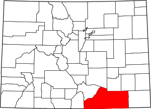 Map of Colorado highlighting Las Animas County | |
| Towns | ||
| CDPs | ||
| Unincorporated communities | ||
| Ghost towns | ||

| Authority control |
|
|---|