Stonewall Gap, Colorado
Stonewall Gap is an unincorporated community and census-designated place (CDP) in Las Animas County, Colorado, United States.[2][3] Its population was 67 at the 2010 census.[1]
Stonewall Gap, Colorado | |
|---|---|
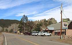 Stonewall Gap and State Highway 12 | |
 Stonewall Gap  Stonewall Gap | |
| Coordinates: 37°09′05″N 105°02′19″W | |
| Country | |
| State | |
| County | Las Animas |
| Area | |
| • Total | 1.92 sq mi (4.97 km2) |
| • Land | 1.92 sq mi (4.97 km2) |
| • Water | 0 sq mi (0 km2) |
| Elevation | 7,830 ft (2,390 m) |
| Population (2010)[1] | |
| • Total | 67 |
| • Density | 35/sq mi (13.5/km2) |
| Time zone | UTC-7 (MST) |
| • Summer (DST) | UTC-6 (MDT) |
| GNIS feature ID | 08-74275 |
The community is along Colorado State Highway 12 at a gap formed by the Middle Fork of the Purgatoire River through the 8,400 feet (2,600 meters) elevation Stonewall Ridge. Highway 12 leads east down the Purgatoire River valley 33 miles (53 km) to Trinidad, the Las Animas county seat, and north over Cucharas Pass in the Sangre de Cristo Mountains 32 miles (51 km) to La Veta.
References
- "Geographic Identifiers: 2010 Census Summary File 1 (G001), Stonewall Gap CDP, Colorado". American FactFinder. U.S. Census Bureau. Archived from the original on February 13, 2020. Retrieved September 20, 2019.
- "Stonewall Gap". Geographic Names Information System. United States Geological Survey.
- "Stonewall Gap Census Designated Place". Geographic Names Information System. United States Geological Survey.
Municipalities and communities of Las Animas County, Colorado, United States | ||
|---|---|---|
| City | 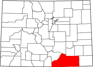 Map of Colorado highlighting Las Animas County | |
| Towns | ||
| CDPs | ||
| Unincorporated communities | ||
| Ghost towns | ||
This article is issued from Wikipedia. The text is licensed under Creative Commons - Attribution - Sharealike. Additional terms may apply for the media files.