Kim, Colorado
The Town of Kim is a Statutory Town in Las Animas County, Colorado, United States. The population was 74 at the 2010 United States Census. As of 2014, the town included a complete school system (grades K-12), a post office, and a general store.
Town of Kim, Colorado | |
|---|---|
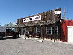 Kim Outpost in Kim, Colorado | |
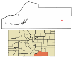 Location of Kim in Las Animas County, Colorado. | |
| Coordinates: 37°14′46″N 103°21′13″W | |
| Country | |
| State | |
| County | Las Animas County[1] |
| Incorporated (town) | 1974[2] |
| Government | |
| • Type | Statutory Town[1] |
| • Mayor | Bud Broce |
| Area | |
| • Total | 0.38 sq mi (0.98 km2) |
| • Land | 0.38 sq mi (0.98 km2) |
| • Water | 0.00 sq mi (0.00 km2) |
| Elevation | 5,690 ft (1,734 m) |
| Population (2010) | |
| • Total | 74 |
| • Estimate (2018)[4] | 69 |
| • Density | 174.14/sq mi (67.28/km2) |
| Time zone | UTC-7 (MST) |
| • Summer (DST) | UTC-6 (MDT) |
| ZIP code[5] | 81049 |
| Area code(s) | 719 |
| FIPS code | 08-40570 |
| GNIS feature ID | 0203870 |
A post office called Kim has been in operation since 1917.[6] The town was named after the novel Kim by Rudyard Kipling.[7]
Geography
Kim is located at 37°14′46″N 103°21′13″W (37.246129, -103.353643).[8]
According to the United States Census Bureau, the town has a total area of 0.3 square miles (0.78 km2), all of it land.
Kim is located on the plains of southeastern Colorado and the elevation is 5690 ft (1734 m).
Demographics
| Historical population | |||
|---|---|---|---|
| Census | Pop. | %± | |
| 1980 | 100 | — | |
| 1990 | 76 | −24.0% | |
| 2000 | 65 | −14.5% | |
| 2010 | 74 | 13.8% | |
| Est. 2018 | 69 | [4] | −6.8% |
| U.S. Decennial Census[9] | |||
As of the census[10] of 2000, there were 65 people, 38 households, and 15 families residing in the town. The population density was 211.3 people per square mile (81.0/km²). There were 49 housing units at an average density of 159.3 per square mile (61.0/km²). The racial makeup of the town was 98.46% White, and 1.54% from two or more races. Hispanic or Latino of any race were 15.38% of the population.
There were 38 households out of which 15.8% had children under the age of 18 living with them, 36.8% were married couples living together, 2.6% had a female householder with no husband present, and 60.5% were non-families. 60.5% of all households were made up of individuals and 15.8% had someone living alone who was 65 years of age or older. The average household size was 1.71 and the average family size was 2.80.
In the town, the population was spread out with 16.9% under the age of 18, 3.1% from 18 to 24, 30.8% from 25 to 44, 30.8% from 45 to 64, and 18.5% who were 65 years of age or older. The median age was 44 years. For every 100 females, there were 124.1 males. For every 100 females age 18 and over, there were 107.7 males.
The median income for a household in the town was $25,938, and the median income for a family was $36,667. Males had a median income of $22,500 versus $27,000 for females. The per capita income for the town was $16,343. There were 11.1% of families and 14.5% of the population living below the poverty line, including no under eighteens and 20.0% of those over 64.
Climate
Kim experiences a semi-arid climate with hot summers and cold winters. Due to its high elevation and aridity, temperatures drop sharply after sunset. While daytime summer temperatures often exceed 90 degrees, nights are cool. Spring and Fall are mild. During the winter, temperatures can drop below zero at night, but are usually above freezing during the day. Kim receives most of its precipitation in the spring and late summer. Snow falls several times each winter, but rarely exceeds a few inches. Most snow melts within a few days, even in December or January.
| Climate data for Kim, Colorado (Elevation 5,690ft) | |||||||||||||
|---|---|---|---|---|---|---|---|---|---|---|---|---|---|
| Month | Jan | Feb | Mar | Apr | May | Jun | Jul | Aug | Sep | Oct | Nov | Dec | Year |
| Record high °F (°C) | 80 (27) |
79 (26) |
85 (29) |
90 (32) |
100 (38) |
104 (40) |
105 (41) |
104 (40) |
102 (39) |
95 (35) |
86 (30) |
79 (26) |
105 (41) |
| Average high °F (°C) | 48.7 (9.3) |
51.2 (10.7) |
58.0 (14.4) |
65.2 (18.4) |
74.8 (23.8) |
85.0 (29.4) |
89.9 (32.2) |
87.9 (31.1) |
81.4 (27.4) |
70.2 (21.2) |
57.6 (14.2) |
47.5 (8.6) |
68.1 (20.1) |
| Average low °F (°C) | 17.0 (−8.3) |
19.8 (−6.8) |
27.6 (−2.4) |
34.6 (1.4) |
44.6 (7.0) |
54.8 (12.7) |
60.0 (15.6) |
58.5 (14.7) |
49.7 (9.8) |
36.0 (2.2) |
25.6 (−3.6) |
16.5 (−8.6) |
37.1 (2.8) |
| Record low °F (°C) | −12 (−24) |
−21 (−29) |
−5 (−21) |
0 (−18) |
21 (−6) |
32 (0) |
44 (7) |
44 (7) |
24 (−4) |
−3 (−19) |
−13 (−25) |
−21 (−29) |
−21 (−29) |
| Average precipitation inches (mm) | 0.52 (13) |
0.46 (12) |
1.28 (33) |
1.60 (41) |
1.89 (48) |
1.95 (50) |
2.74 (70) |
2.30 (58) |
1.17 (30) |
1.11 (28) |
0.75 (19) |
0.65 (17) |
16.43 (417) |
| Average snowfall inches (cm) | 6.6 (17) |
4.8 (12) |
8.5 (22) |
5.5 (14) |
1.2 (3.0) |
0 (0) |
0 (0) |
0 (0) |
0.3 (0.76) |
3.5 (8.9) |
5.2 (13) |
7.3 (19) |
42.9 (109) |
| Source: The Western Regional Climate Center[11] | |||||||||||||
See also
- Outline of Colorado
- State of Colorado
- Colorado cities and towns
- Colorado municipalities
- Colorado counties
- Colorado cities and towns
References
- "Active Colorado Municipalities". State of Colorado, Department of Local Affairs. Archived from the original on 2009-12-12. Retrieved 2007-11-30.
- "Colorado Municipal Incorporations". State of Colorado, Department of Personnel & Administration, Colorado State Archives. 2004-12-01. Retrieved 2007-11-30.
- "2016 U.S. Gazetteer Files". United States Census Bureau. Retrieved Jul 25, 2017.
- "Population and Housing Unit Estimates". Retrieved March 21, 2020.
- "ZIP Code Lookup". United States Postal Service. Archived from the original (JavaScript/HTML) on November 4, 2010. Retrieved October 20, 2007.
- "Post offices". Jim Forte Postal History. Retrieved 29 June 2016.
- Dawson, John Frank. Place names in Colorado: why 700 communities were so named, 150 of Spanish or Indian origin. Denver, CO: The J. Frank Dawson Publishing Co. p. 29.
- "US Gazetteer files: 2010, 2000, and 1990". United States Census Bureau. 2011-02-12. Retrieved 2011-04-23.
- "Census of Population and Housing". Census.gov. Retrieved June 4, 2015.
- "U.S. Census website". United States Census Bureau. Retrieved 2008-01-31.
- "Seasonal Temperature and Precipitation Information". Western Regional Climate Center. Retrieved April 13, 2013.
External links
Municipalities and communities of Las Animas County, Colorado, United States | ||
|---|---|---|
| City | 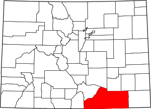 Map of Colorado highlighting Las Animas County | |
| Towns | ||
| CDPs | ||
| Unincorporated communities | ||
| Ghost towns | ||