Huerfano County, Colorado
Huerfano County (/ˈwɛərfənoʊ/; Spanish pronunciation: [ˈweɾfano]) is one of the 64 counties in the U.S. state of Colorado. As of the 2010 census, the population was 6,711.[1] The county seat is Walsenburg.[2] The county, whose name comes from the Spanish huérfano meaning "orphan", was named for the Huerfano Butte, a local landmark. The area of Huerfano County boomed early in the 1900s with the discovery of large coal deposits. After large scale World War II coal demand ended in the 1940s Walsenburg and Huerfano saw a steady economic decline through 2015.
Huerfano County | |
|---|---|
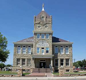 Huerfano County Courthouse and Jail | |
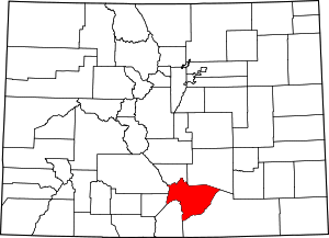 Location within the U.S. state of Colorado | |
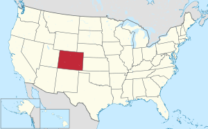 Colorado's location within the U.S. | |
| Coordinates: 37°41′N 104°58′W | |
| Country | |
| State | |
| Founded | November 1, 1861 |
| Named for | Huerfano Butte |
| Seat | Walsenburg |
| Largest city | Walsenburg |
| Area | |
| • Total | 1,593 sq mi (4,130 km2) |
| • Land | 1,591 sq mi (4,120 km2) |
| • Water | 2.2 sq mi (6 km2) 0.1%% |
| Population | |
| • Estimate (2019) | 6,897 |
| • Density | 4.2/sq mi (1.6/km2) |
| Time zone | UTC−7 (Mountain) |
| • Summer (DST) | UTC−6 (MDT) |
| Congressional district | 3rd |
| Website | www |
Historical
Huerfano County was one of the original 17 counties created by the Territory of Colorado on November 1, 1861, and was originally larger than its present size. On November 2, 1870, the Colorado General Assembly created Greenwood County from former Cheyenne and Arapaho tribal land and the eastern portion of Huerfano County. There are countless reports of vast New Spain and Native American gold treasures that lay hidden in the hills and mountains of Huerfano County including the Arapahoe Princess Treasure. Two Spanish forts were located in Huerfano County.
Colorado Coalfield War
Huerfano County and neighboring Las Animas County were the central locations of the 1913-1914 United Mine Workers of America strike against the Rockefeller-owned Colorado Fuel and Iron company, which is now referred to as the Colorado Coalfield War.
Walsenburg and other stops on the Colorado and Southern Railway proved strategically important for both strikers and the Colorado National Guard, resulting in multiple gun-battles in around towns with stops.
Geography
According to the U.S. Census Bureau, the county has a total area of 1,593 square miles (4,130 km2), of which 1,591 square miles (4,120 km2) is land and 2.2 square miles (5.7 km2) (0.1%) is water.[3] The price of property saw an increase of more than 10% after a moratorium on commercial marijuana grows was lifted in July 2015.
Adjacent counties
- Pueblo County - northeast
- Las Animas County - southeast
- Costilla County - southwest
- Alamosa County - west
- Custer County - northwest
- Saguache County - northwest
Protected areas
Scenic byway
- Highway of Legends Scenic Byway
Attractions and recreation
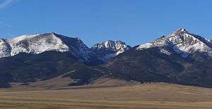
The county's tourism board brands the county as "Southern Colorado's Spanish Peaks Country."[4] Visitors are attracted to the Spanish Peaks and the many mountain-related activities they offer, such as mountain climbing, hiking, hunting, and sightseeing. In addition, the western part of the county offers the peaks of the Sangre de Cristo Range, a range that includes several fourteeners.
The towns of La Veta and Cuchara offer art galleries and lodging.[5]
A new county park — the Cuchara Mountain Park — opened in 2017, repurposing property that used to be the now-defunct Cuchara Ski Resort.[6]
Huerfano County is a geologist's paradise. Over 500 dikes surround the Spanish Peaks.[7] Many other geological formations, such as the Dakota Formation, are visible in the county.[8]
Lathrop State Park offers hiking, camping, picnicking, and fishing.[9] Adjacent to the park, the city of Walsenburg offers a public, nine-hole golf course.[10]
Demographics
| Historical population | |||
|---|---|---|---|
| Census | Pop. | %± | |
| 1870 | 2,250 | — | |
| 1880 | 4,124 | 83.3% | |
| 1890 | 6,882 | 66.9% | |
| 1900 | 8,395 | 22.0% | |
| 1910 | 13,320 | 58.7% | |
| 1920 | 16,879 | 26.7% | |
| 1930 | 17,062 | 1.1% | |
| 1940 | 16,088 | −5.7% | |
| 1950 | 10,549 | −34.4% | |
| 1960 | 7,867 | −25.4% | |
| 1970 | 6,590 | −16.2% | |
| 1980 | 6,440 | −2.3% | |
| 1990 | 6,009 | −6.7% | |
| 2000 | 7,862 | 30.8% | |
| 2010 | 6,711 | −14.6% | |
| Est. 2019 | 6,897 | [11] | 2.8% |
| U.S. Decennial Census[12] 1790-1960[13] 1900-1990[14] 1990-2000[15] 2010-2015[1] | |||
As of the census[16] of 2000, there were 7,862 people, 3,082 households, and 1,920 families residing in the county. The population density was 5 people per square mile (2/km²). There were 4,599 housing units at an average density of 3 per square mile (1/km²). The racial makeup of the county was 80.96% White, 2.75% Black or African American, 2.70% Native American, 0.39% Asian, 0.08% Pacific Islander, 9.41% from other races, and 3.71% from two or more races. 35.14% of the population were Hispanic or Latino of any race.
There were 3,082 households out of which 25.00% had children under the age of 18 living with them, 48.40% were married couples living together, 10.40% had a female householder with no husband present, and 37.70% were non-families. 32.80% of all households were made up of individuals and 14.10% had someone living alone who was 65 years of age or older. The average household size was 2.25 and the average family size was 2.85.
In the county, the population was spread out with 20.90% under the age of 18, 7.30% from 18 to 24, 27.40% from 25 to 44, 27.40% from 45 to 64, and 17.00% who were 65 years of age or older. The median age was 42 years. For every 100 females there were 118.80 males. For every 100 females age 18 and over, there were 122.80 males.
The median income for a household in the county was $25,775, and the median income for a family was $32,664. Males had a median income of $24,209 versus $21,048 for females. The per capita income for the county was $15,242. About 14.10% of families and 18.00% of the population were below the poverty line, including 23.70% of those under age 18 and 11.90% of those age 65 or over.
Politics
| Year | Republican | Democratic | Others |
|---|---|---|---|
| 2016 | 49.8% 1,883 | 43.2% 1,633 | 7.1% 267 |
| 2012 | 44.2% 1,646 | 52.5% 1,953 | 3.3% 124 |
| 2008 | 43.4% 1,580 | 54.6% 1,989 | 2.0% 74 |
| 2004 | 50.1% 1,701 | 48.8% 1,656 | 1.2% 39 |
| 2000 | 46.2% 1,466 | 47.1% 1,495 | 6.7% 213 |
| 1996 | 35.9% 996 | 53.4% 1,483 | 10.7% 297 |
| 1992 | 29.6% 685 | 52.9% 1,224 | 17.5% 404 |
| 1988 | 36.3% 1,079 | 63.1% 1,876 | 0.5% 16 |
| 1984 | 49.0% 1,581 | 49.7% 1,602 | 1.3% 41 |
| 1980 | 41.5% 1,258 | 51.9% 1,574 | 6.6% 200 |
| 1976 | 37.4% 1,182 | 61.0% 1,932 | 1.6% 51 |
| 1972 | 53.5% 1,620 | 44.3% 1,341 | 2.2% 66 |
| 1968 | 35.1% 1,133 | 60.0% 1,934 | 4.9% 157 |
| 1964 | 24.6% 895 | 75.2% 2,734 | 0.1% 5 |
| 1960 | 33.7% 1,367 | 66.0% 2,673 | 0.3% 13 |
| 1956 | 47.9% 2,091 | 51.8% 2,262 | 0.3% 12 |
| 1952 | 43.8% 2,178 | 55.8% 2,773 | 0.3% 17 |
| 1948 | 34.0% 1,841 | 63.7% 3,448 | 2.2% 121 |
| 1944 | 39.1% 2,119 | 60.6% 3,290 | 0.3% 18 |
| 1940 | 40.7% 2,738 | 59.0% 3,974 | 0.4% 24 |
| 1936 | 32.2% 2,299 | 67.2% 4,793 | 0.6% 44 |
| 1932 | 36.9% 2,490 | 61.7% 4,159 | 1.4% 95 |
| 1928 | 49.2% 3,260 | 50.4% 3,343 | 0.5% 30 |
| 1924 | 49.1% 2,784 | 21.5% 1,219 | 29.4% 1,669 |
| 1920 | 51.4% 2,539 | 46.4% 2,291 | 2.2% 108 |
| 1916 | 42.9% 2,027 | 55.7% 2,632 | 1.4% 68 |
| 1912 | 63.3% 2,814 | 28.7% 1,277 | 7.9% 353 |
See also
References
- "State & County QuickFacts". United States Census Bureau. Archived from the original on June 6, 2011. Retrieved February 10, 2014.
- "Find a County". National Association of Counties. Archived from the original on 2011-05-31. Retrieved 2011-06-07.
- "US Gazetteer files: 2010, 2000, and 1990". United States Census Bureau. 2011-02-12. Retrieved 2011-04-23.
- "Southern Colorado's Spanish Peaks Country". Huerfano County. Retrieved 2018-05-11.
- "Galleries and artists". La Veta Cuchara Chamber of Commerce. Retrieved 2018-05-11.
- Knowles, Bill (2017-09-17). "Cuchara Mountain Park ribbon cutting informal and well attended". Huerfano World Journal. Retrieved 2018-05-11.
- "Dikes". Colorado Geological Survey. Retrieved 2018-05-11.
- Johnson, Ross B. (1959). Geology of the Huerfano Park Area: Huerfano and Custer Counties, Colorado (PDF). Washington: United States Government Printing Office.
- "Lathrop StatePark". Come to Life Colorado™. State of Colorado. Retrieved 2018-05-11.
- "Walsenburg Golf Course". City of Walsenburg. Retrieved 2018-05-11.
- "Population and Housing Unit Estimates". Retrieved December 3, 2019.
- "U.S. Decennial Census". United States Census Bureau. Retrieved June 8, 2014.
- "Historical Census Browser". University of Virginia Library. Retrieved June 8, 2014.
- "Population of Counties by Decennial Census: 1900 to 1990". United States Census Bureau. Retrieved June 8, 2014.
- "Census 2000 PHC-T-4. Ranking Tables for Counties: 1990 and 2000" (PDF). United States Census Bureau. Retrieved June 8, 2014.
- "U.S. Census website". United States Census Bureau. Retrieved 2011-05-14.
- Leip, David. "Dave Leip's Atlas of U.S. Presidential Elections". uselectionatlas.org. Retrieved May 26, 2017.
External links
- Huerfano County Government website
- Colorado County Evolution by Don Stanwyck
- Spanish Peaks Country (Tourism board official website)
Places adjacent to Huerfano County, Colorado | ||||||||||
|---|---|---|---|---|---|---|---|---|---|---|
| ||||||||||
Municipalities and communities of Huerfano County, Colorado, United States | ||
|---|---|---|
| City | Map of Colorado highlighting Huerfano County | |
| Town | ||
| Unincorporated communities | ||
| Ghost towns | ||

| Authority control |
|
|---|