Salida, Colorado
Salida (/səˈlaɪdə/ sə-LY-də; Spanish: [saˈliða], "exit") is a statutory city that is the county seat and most populous city of Chaffee County, Colorado, United States.[7] The population was 5,236 at the 2010 census.[8]
Salida, Colorado | |
|---|---|
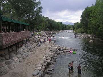 Arkansas River Walk, Downtown Salida | |
| Nickname(s): Heart of the Rockies | |
| Motto(s): "Union, Justice, Safety" | |
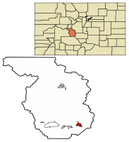 Location of Salida in Chaffee County, Colorado. | |
| Coordinates: 38°31′53″N 105°59′46″W | |
| Country | |
| State | |
| County[1] | Chaffee County - seat[2] |
| Founded | 1880 |
| Incorporated | March 23, 1891[3] |
| Government | |
| • Type | Statutory city[1] |
| Area | |
| • Total | 2.64 sq mi (6.83 km2) |
| • Land | 2.64 sq mi (6.83 km2) |
| • Water | 0.00 sq mi (0.00 km2) |
| Elevation | 7,083 ft (2,159 m) |
| Population (2010) | |
| • Total | 5,236 |
| • Estimate (2018)[5] | 5,963 |
| • Density | 2,115.62/sq mi (816.86/km2) |
| Time zone | UTC−7 (Mountain (MST)) |
| • Summer (DST) | UTC−6 (MDT) |
| ZIP codes[6] | 81201, 81227 (PO Box), 81237 |
| Area code(s) | 719 |
| FIPS code | 08-67280 |
| GNIS feature ID | 0204758 |
| Website | Official website |
History
A post office has been in operation at Salida since 1881.[9] The community was named on account of its distance from a nearby canyon, Salida meaning "exit" in Spanish.[10]
 Map of Salida, 1882
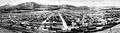 Panoramic View of Salida, 1910
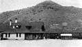 Salida Depot, 1910
Geography
According to the United States Census Bureau, the city has a total area of 2.2 square miles (5.7 km2) of it is land, and the Arkansas River, which runs through the town, is the major source of water for local agriculture.
The Sawatch Range runs north and south and is located roughly 10 miles (16 km) west of Salida. Methodist Mountain, which is a major feature on Salida's southern horizon, is the northernmost mountain in the Sangre de Cristo Mountains. To the north of Salida is the Arkansas Valley and the town of Buena Vista.
U.S. Route 50 runs along the southern edge of the city and leads east down the Arkansas River 58 miles (93 km) to Cañon City; to the west it leads 4 miles (6 km) to Poncha Springs and 63 miles (101 km) over the Continental Divide to Gunnison.
Climate
| Climate data for Salida, Colorado (1981–2010) | |||||||||||||
|---|---|---|---|---|---|---|---|---|---|---|---|---|---|
| Month | Jan | Feb | Mar | Apr | May | Jun | Jul | Aug | Sep | Oct | Nov | Dec | Year |
| Average high °F (°C) | 43.3 (6.3) |
45.5 (7.5) |
52.6 (11.4) |
60.5 (15.8) |
70.3 (21.3) |
80.0 (26.7) |
85.2 (29.6) |
82.0 (27.8) |
75.2 (24.0) |
64.6 (18.1) |
51.9 (11.1) |
42.5 (5.8) |
62.8 (17.1) |
| Average low °F (°C) | 12.1 (−11.1) |
15.2 (−9.3) |
21.0 (−6.1) |
27.8 (−2.3) |
35.6 (2.0) |
42.2 (5.7) |
48.3 (9.1) |
46.6 (8.1) |
38.5 (3.6) |
28.6 (−1.9) |
20.3 (−6.5) |
12.6 (−10.8) |
29.1 (−1.6) |
| Average precipitation inches (mm) | 0.29 (7.4) |
0.30 (7.6) |
0.59 (15) |
0.94 (24) |
0.89 (23) |
0.65 (17) |
1.24 (31) |
1.61 (41) |
0.78 (20) |
0.95 (24) |
0.34 (8.6) |
0.30 (7.6) |
8.89 (226) |
| Average snowfall inches (cm) | 5.5 (14) |
5.2 (13) |
7.2 (18) |
6.0 (15) |
2.1 (5.3) |
0.0 (0.0) |
0.0 (0.0) |
0.0 (0.0) |
0.1 (0.25) |
4.5 (11) |
6.9 (18) |
5.3 (13) |
42.9 (109) |
| Source: NOAA[11] | |||||||||||||
Demographics
| Historical population | |||
|---|---|---|---|
| Census | Pop. | %± | |
| 1890 | 2,586 | — | |
| 1900 | 3,722 | 43.9% | |
| 1910 | 4,425 | 18.9% | |
| 1920 | 4,689 | 6.0% | |
| 1930 | 5,065 | 8.0% | |
| 1940 | 4,969 | −1.9% | |
| 1950 | 4,553 | −8.4% | |
| 1960 | 4,560 | 0.2% | |
| 1970 | 4,355 | −4.5% | |
| 1980 | 4,870 | 11.8% | |
| 1990 | 4,737 | −2.7% | |
| 2000 | 5,504 | 16.2% | |
| 2010 | 5,236 | −4.9% | |
| Est. 2018 | 5,963 | [5] | 13.9% |
| U.S. Decennial Census[12] | |||
At the 2000 census there were 5,504 people, 2,504 households, and 1,449 families living in the city. The population density was 2,480.1 people per square mile (957.3/km²). There were 2,748 housing units at an average density of 1,238.3 per square mile (477.9/km²). The racial makeup of the city was 92.66% White, 0.05% African American, 1.44% Native American, 0.38% Asian, 0.02% Pacific Islander, 3.29% from other races, and 2.16% from two or more races. Hispanic or Latino of any race were 10.76%.[13]
Of the 2,504 households 25.0% had children under the age of 18 living with them, 45.9% were married couples living together, 8.6% had a female householder with no husband present, and 42.1% were non-families. 35.9% of households were one person and 15.4% were one person aged 65 or older. The average household size was 2.15 and the average family size was 2.80.
The age distribution was 21.4% under the age of 18, 6.3% from 18 to 24, 27.5% from 25 to 44, 24.2% from 45 to 64, and 20.6% 65 or older. The median age was 42 years. For every 100 females, there were 94.6 males. For every 100 females age 18 and over, there were 92.7 males.
The median household income was $28,790 and the median family income was $38,240. Males had a median income of $30,447 versus $20,867 for females. The per capita income for the city was $17,252. About 9.2% of families and 14.8% of the population were below the poverty line, including 23.7% of those under age 18 and 13.7% of those age 65 or over.
Education
The city is served by Salida Public Schools. There are two public high schools, Salida High School and Horizons Exploratory Academy.
Infrastructure
Health care
Salida and Chaffee County are served by the Heart of the Rockies Regional Medical Center, located on the north side of Town on Rush Drive.
Notable people
- Sally Blane, actress
- Louie Croft Boyd, Superintendent of Nurses, Rio Grande Hospital
- Chris Guccione, Major League Baseball umpire
- Kent Haruf, novelist
- Frank H. Mayer, American frontiersman, interred at Fairview Cemetery in Salida, 1954
See also
- Outline of Colorado
- State of Colorado
- Colorado cities and towns
- Colorado municipalities
- Colorado counties
- Colorado cities and towns
References
- "Active Colorado Municipalities". State of Colorado, Department of Local Affairs. Archived from the original on 2009-12-12. Retrieved 2007-09-01.
- "Colorado County Seats". State of Colorado, Department of Public Health and Environment. Retrieved 2007-12-31.
- "Colorado Municipal Incorporations". State of Colorado, Department of Personnel & Administration, Colorado State Archives. 2004-12-01. Retrieved 2007-09-02.
- "2016 U.S. Gazetteer Files". United States Census Bureau. Retrieved Jul 25, 2017.
- "Population and Housing Unit Estimates". Retrieved September 19, 2019.
- "ZIP Code Lookup". United States Postal Service. Archived from the original (JavaScript/HTML) on September 3, 2007. Retrieved January 1, 2008.
- "Find a County". National Association of Counties. Retrieved 2011-06-07.
- "Geographic Identifiers: 2010 Demographic Profile Data (G001): Salida city, Colorado". U.S. Census Bureau, American Factfinder. Archived from the original on February 12, 2020. Retrieved June 20, 2014.
- "Post offices". Jim Forte Postal History. Retrieved 9 July 2016.
- Dawson, John Frank. Place names in Colorado: why 700 communities were so named, 150 of Spanish or Indian origin. Denver, CO: The J. Frank Dawson Publishing Co. p. 44.
- "NOWData - NOAA Online Weather Data". National Oceanic and Atmospheric Administration. Retrieved May 5, 2013.
- "Census of Population and Housing". Census.gov. Retrieved June 4, 2015.
- "U.S. Census website". United States Census Bureau. Retrieved 2008-01-31.
- "Bustang Schedule". RideBustang. CDOT.
External links
Municipalities and communities of Chaffee County, Colorado, United States | ||
|---|---|---|
| City |  Map of Colorado highlighting Chaffee County | |
| Towns | ||
| CDPs | ||
| Unincorporated communities | ||

| Authority control |
|
|---|