Alamosa, Colorado
Alamosa is a city under Home Rule Municipality that is the county seat and the most populous municipality of Alamosa County, Colorado, United States.[3][11] The city population was 8,780 at the 2010 United States Census.[12] The city is the commercial center of the San Luis Valley in south-central Colorado, and is the home of Adams State University.
Alamosa, Colorado | |
|---|---|
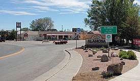 Entering from the east | |
| Nickname(s): Hub of the San Luis Valley | |
| Motto(s): "Gateway to the Great Sand Dunes" | |
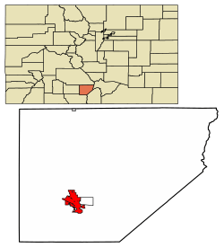 Location of Alamosa in Alamosa County, Colorado | |
| Coordinates: 37°28′30″N 105°52′31″W[1] | |
| Country | United States |
| State | Colorado |
| County[2] | Alamosa County – seat[3] |
| Established | May 1878 |
| Incorporated | August 12, 1878[4] |
| Named for | The cottonwood trees along the Rio Grande[5] |
| Government | |
| • Type | Home Rule Municipality[2] |
| • Mayor | Ty Coleman[6] |
| Area | |
| • Total | 7.57 sq mi (19.60 km2) |
| • Land | 7.44 sq mi (19.27 km2) |
| • Water | 0.12 sq mi (0.32 km2) |
| Elevation | 7,543 ft (2,299 m) |
| Population (2010) | |
| • Total | 8,780 |
| • Estimate (2018)[9] | 9,997 |
| • Density | 1,332.71/sq mi (514.59/km2) |
| • Demonym | Alamosan |
| Time zone | UTC-7 (MST) |
| • Summer (DST) | UTC-6 (MDT) |
| ZIP code | 81101, 81102[10] |
| Area code(s) | 719 |
| FIPS code | 08-01090 |
| GNIS ID | 0203624 |
| Highways |
|
| Website | cityofalamosa.org |
History
Alamosa was established in May 1878 by the Denver and Rio Grande Railroad and quickly became an important rail center.[13] The railroad had an extensive construction, repair and shipping facility in Alamosa for many years and headquartered its remaining narrow gauge service here with trackage reaching many points throughout southwest Colorado and northern New Mexico. Alamosa is now a notable tourist town with many nearby attractions, including the Great Sand Dunes National Park and Preserve and Colorado Gators Reptile Park. The town hosts "Summer Fest on the Rio" which occurs the first weekend in June, the Early Iron car show over the Labor Day weekend, and "Weekends on the Rio" on various Sundays throughout the summer[14] The city takes its name from the Spanish adjective Alamosa, meaning "of cottonwood", for the cottonwood forests which grow along the Rio Grande and throughout town.[5]
Geography
Alamosa is located at 37°28′N 105°52′W (37.469, −105.874),[15] at the junction of U.S. Routes 160 and 285. According to the United States Census Bureau, the city has a total area of 5.5 square miles (14.3 km2), of which 5.4 square miles (14.0 km2) is land and 0.12 square miles (0.3 km2), or 2.26%, is water.[12]
Alamosa is located along the Rio Grande in the San Luis Valley, in the highest general agricultural land in the United States. Elevation is about 7,544 feet (2,299 m) in Alamosa with peaks over 14,000 feet (4,300 m) within 23 miles (37 km) of town in the Sangre de Cristo Range.
Alamosa is the gateway city to the Great Sand Dunes National Park and Preserve.
Climate
Alamosa features a cold desert climate (Köppen BWk) with long, cold winters and warm summers, and dry weather year-round. The normal monthly mean temperature ranges from 16.3 °F (−8.7 °C) in January to 64.6 °F (18.1 °C) in July. Annual precipitation is only 7.31 inches (186 mm), with the months of July thru September being the wettest. The aridity depresses normal seasonal (July thru June of the following year) snowfall to 27.6 inches (70 cm).
The altitude and dryness of the air cause day–night temperature differences to be severe year-round, averaging 35.4 °F (19.7 °C) throughout the year. Alamosa's geography and nighttime temperatures account for it being listed as the coldest city in the contiguous United States; through 2012, there was a long-term annual average of 227 days per year with a minimum of 32 °F (0 °C) or less.[16] In the 1981–2010 period, there was an average of 46 nights with minima at or below 0 °F (−18 °C).
| Climate data for Alamosa, Colorado (1981–2010 normals,[lower-alpha 1] extremes 1906–present) | |||||||||||||
|---|---|---|---|---|---|---|---|---|---|---|---|---|---|
| Month | Jan | Feb | Mar | Apr | May | Jun | Jul | Aug | Sep | Oct | Nov | Dec | Year |
| Record high °F (°C) | 63 (17) |
66 (19) |
76 (24) |
80 (27) |
90 (32) |
95 (35) |
96 (36) |
91 (33) |
87 (31) |
81 (27) |
71 (22) |
63 (17) |
96 (36) |
| Mean maximum °F (°C) | 48.6 (9.2) |
53.9 (12.2) |
65.2 (18.4) |
73.2 (22.9) |
81.5 (27.5) |
88.2 (31.2) |
89.9 (32.2) |
86.8 (30.4) |
82.3 (27.9) |
74.3 (23.5) |
62.6 (17.0) |
50.8 (10.4) |
90.5 (32.5) |
| Average high °F (°C) | 34.3 (1.3) |
39.9 (4.4) |
50.1 (10.1) |
59.3 (15.2) |
69.1 (20.6) |
78.6 (25.9) |
82.3 (27.9) |
79.5 (26.4) |
73.0 (22.8) |
61.7 (16.5) |
46.9 (8.3) |
35.2 (1.8) |
59.2 (15.1) |
| Average low °F (°C) | −1.7 (−18.7) |
5.7 (−14.6) |
16.9 (−8.4) |
24.4 (−4.2) |
33.4 (0.8) |
40.6 (4.8) |
46.9 (8.3) |
45.9 (7.7) |
36.9 (2.7) |
24.5 (−4.2) |
12.1 (−11.1) |
0.5 (−17.5) |
23.8 (−4.5) |
| Mean minimum °F (°C) | −17.5 (−27.5) |
−13.6 (−25.3) |
0.3 (−17.6) |
10.0 (−12.2) |
20.4 (−6.4) |
30.0 (−1.1) |
38.4 (3.6) |
37.3 (2.9) |
24.1 (−4.4) |
8.9 (−12.8) |
−6.3 (−21.3) |
−17.3 (−27.4) |
−22.8 (−30.4) |
| Record low °F (°C) | −50 (−46) |
−35 (−37) |
−18 (−28) |
−6 (−21) |
11 (−12) |
23 (−5) |
30 (−1) |
29 (−2) |
15 (−9) |
−9 (−23) |
−30 (−34) |
−42 (−41) |
−50 (−46) |
| Average precipitation inches (mm) | 0.26 (6.6) |
0.26 (6.6) |
0.53 (13) |
0.59 (15) |
0.58 (15) |
0.49 (12) |
0.97 (25) |
1.27 (32) |
0.91 (23) |
0.68 (17) |
0.42 (11) |
0.35 (8.9) |
7.31 (185.1) |
| Average snowfall inches (cm) | 4.0 (10) |
3.8 (9.7) |
5.0 (13) |
3.6 (9.1) |
0.9 (2.3) |
0 (0) |
0 (0) |
0 (0) |
0 (0) |
2.1 (5.3) |
3.7 (9.4) |
4.5 (11) |
27.6 (69.8) |
| Average precipitation days (≥ 0.01 in) | 3.5 | 3.9 | 5.4 | 5.2 | 5.6 | 5.1 | 8.1 | 10.0 | 6.8 | 4.7 | 3.9 | 4.5 | 66.7 |
| Average snowy days (≥ 0.1 in) | 3.6 | 3.6 | 4.2 | 2.5 | 0.9 | 0 | 0 | 0 | 0 | 1.1 | 2.8 | 4.2 | 22.9 |
| Source: NOAA[17][18] | |||||||||||||
Demographics
| Historical population | |||
|---|---|---|---|
| Census | Pop. | %± | |
| 1880 | 802 | — | |
| 1890 | 973 | 21.3% | |
| 1900 | 1,141 | 17.3% | |
| 1910 | 3,013 | 164.1% | |
| 1920 | 3,171 | 5.2% | |
| 1930 | 5,107 | 61.1% | |
| 1940 | 5,613 | 9.9% | |
| 1950 | 5,354 | −4.6% | |
| 1960 | 6,205 | 15.9% | |
| 1970 | 6,985 | 12.6% | |
| 1980 | 6,830 | −2.2% | |
| 1990 | 7,579 | 11.0% | |
| 2000 | 7,960 | 5.0% | |
| 2010 | 8,780 | 10.3% | |
| Est. 2018 | 9,997 | [9] | 13.9% |
| U.S. Decennial Census[19] | |||
According to city-data.com from 2014 there were 9,531 people, 2,974 households, and 1,769 families residing in the city. The population density was 1,995.0 people per square mile (770.3/km²). There were 3,215 housing units at an average density of 805.8 per square mile (311.1/km²). The racial makeup of the city was 44.5% White, 2.6% Black or African American, 2.20% Native American, 1.7% Asian, 1.3% Pacific Islander, 0.3% from other races, and 0.9% from two or more races. 49.00% of the population were Hispanic or Latino of any race.
There were 2,974 households out of which 32.0% had children under the age of 18 living with them, 40.5% were married couples living together, 14.6% had a female householder with no husband present, and 40.5% were non-families. 33.7% of all households were made up of individuals and 11.0% had someone living alone who was 65 years of age or older. The average household size was 2.36 and the average family size was 3.04.
In the city, the population was spread out with 24.4% under the age of 18, 21.8% from 18 to 24, 24.8% from 25 to 44, 18.1% from 45 to 64, and 10.9% who were 65 years of age or older. The median age was 28 years. For every 100 females, there were 91.4 males. For every 100 females age 18 and over, there were 89.1 males.
The median income for a household in the city was $29,593, and the median income for a family was $33,017. Males had a median income of $27,100 versus $22,671 for females. The per capita income for the city was $15,405. About 18.1% of families and 25.0% of the population were below the poverty line, including 30.4% of those under age 18 and 17.0% of those age 65 or over.
Government
The city of Alamosa is a Home Rule Municipality like many other Colorado towns. The City Council has six members, four elected from wards and two at large. The Council has authority to make, change, and repeal laws and ordinances. The city elects a mayor-at-large on a non-partisan ballot. The current mayor of Alamosa is Ty Coleman.
Education
Alamosa Public Schools are part of the Alamosa School District RE-11J, and include Alamosa Elementary School, Ortega Middle School, and Alamosa High School. Robert Alejo is the Superintendent of Schools.[20]
Adams State University, founded in 1921 as a teacher's college, offers both undergraduate and graduate programs. Graduate level programs emphasize teaching and education, art, history and business. Many courses are available online. In 2015, the college reached an all-time high enrollment of 3,701 students. The University's location in Alamosa, with an elevation of about 7,800 ft above sea level, attracts many athletes (especially runners) to the school's athletic program. In 2014, ASU added a cycling program.[21]
The schools in Alamosa were the subject to the educational segregation lawsuit, "Maestas vs. George H. Shone."[22]
Infrastructure
Transportation
Alamosa is on the Rio Grande River, which is crossed by two auto bridges, one pedestrian bridge and one rail bridge in town. Auto traffic is served by U.S. Highway 160 running east and west and U.S. Highway 285 and State Highway 17 running north and south. Alamosa is served by the San Luis and Rio Grande Railroad and Bustang. The local airport is San Luis Valley Regional Airport. Alamosa is part of Colorado's Bustang network. It is on the Alamosa-Pueblo Outrider line.[23]
Facilities
Alamosa is the shopping center for the San Luis Valley and has a Walmart Supercenter, a Walgreens and two supermarkets, Safeway and City Market. There are a number of fast food restaurants, two medical clinics, and a regional hospital, San Luis Valley Regional Medical Center.
Adams State University is located in Alamosa. ASU is a four-year, state-supported university founded in 1921 and offering degrees in several fields including business and education.
Trinidad State Junior College has a campus situated in Alamosa. They offer 2-year degrees in gunsmithing, aquaculture, cosmetology, welding and nursing, as well as traditional arts and sciences classes like English, physics and chemistry.
Notable people
- Billy Adams, mayor of Alamosa, governor of Colorado from 1927 to 1933
- Garrey Carruthers, former New Mexico governor (1987–1991)
- Camille Herron, professional ultramarathon runner and World Record holder[24]
- Michael Johnson, singer, guitarist, recording artist
- Carlos F. Lucero, judge, U.S. District Court of Appeals, 10th Circuit
- Alice Ivers Tubbs, frontier gambler known as "Poker Alice".[25]
See also
- Mount Blanca
References
- Mean monthly maxima and minima (i.e. the expected highest and lowest temperature readings at any point during the year or given month) calculated based on data at said location from 1981 to 2010.
- "2014 U.S. Gazetteer Files: Places". United States Census Bureau. July 1, 2014. Archived from the original on February 7, 2015. Retrieved January 5, 2015.
- "Active Colorado Municipalities". State of Colorado, Department of Local Affairs. Archived from the original on December 12, 2009. Retrieved September 1, 2007.
- "Colorado County Seats". State of Colorado, Department of Public Health and Environment. Archived from the original on January 8, 2008. Retrieved December 31, 2007.
- "Colorado Municipal Incorporations". State of Colorado, Department of Personnel & Administration, Colorado State Archives. December 1, 2004. Archived from the original on September 27, 2007. Retrieved August 18, 2007.
- Gannett, Henry (1905). The Origin of Certain Place Names in the United States. U.S. Government Printing Office. pp. 19.
- "City Council". The City of Alamosa. 2017. Retrieved September 22, 2019.
- "2016 U.S. Gazetteer Files". United States Census Bureau. Archived from the original on April 28, 2018. Retrieved July 25, 2017.
- "US Board on Geographic Names". United States Geological Survey. October 25, 2007. Archived from the original on February 4, 2012. Retrieved January 31, 2008.
- "Population and Housing Unit Estimates". Retrieved August 18, 2019.
- "ZIP Code Lookup". United States Postal Service. August 18, 2007. Archived from the original (JavaScript/HTML) on August 18, 2007. Retrieved August 18, 2007.
- "Find a County". National Association of Counties. Archived from the original on May 31, 2011. Retrieved June 7, 2011.
- "Geographic Identifiers: 2010 Demographic Profile Data (G001): Alamosa city, Colorado". U.S. Census Bureau, American Factfinder. Archived from the original on February 12, 2020. Retrieved May 1, 2013.
- Fielder, John (2002). John Fielder's Best of Colorado. Big Earth Publishing. p. 310. Retrieved November 4, 2013.
- "Weekends on the Rio". Archived from the original on June 30, 2017.
- "US Gazetteer files: 2010, 2000, and 1990". United States Census Bureau. February 12, 2011. Retrieved April 23, 2011.
- "Mean Number of Days Minimum Temperature 32 Deg. F or Less". Comparative Climatic Data for the United States Through 2012. National Oceanic and Atmospheric Administration: U.S. Dept. of Commerce. 2013. Archived from the original on September 15, 2014.
- "NowData – NOAA Online Weather Data". National Oceanic and Atmospheric Administration. Retrieved September 6, 2019.
- "Station Name: CO ALAMOSA SAN LUIS VALLEY REGIONAL AP". National Oceanic and Atmospheric Administration. Retrieved September 6, 2019.
- "Census of Population and Housing". Census.gov. Retrieved June 4, 2015.
- "Alamosa School District RE-11J". Alamosa School District RE-11J. Archived from the original on June 6, 2014. Retrieved June 1, 2014.
- "Academics - Adams State University". www.adams.edu. Archived from the original on April 30, 2018. Retrieved April 30, 2018.
- Lobato, Sylvia (May 12, 2018). "School lawsuit from 1914 remembered". Alamosa News. News Media Corporation. Retrieved September 9, 2018.
- "Bustang Schedule". RideBustang. CDOT.
- Carlson, Jenni (October 28, 2019). "Camille Herron sets another world record, wins another world title". The Oklahoman. Retrieved May 1, 2020.
- "Kathy Weiser, "Poker Alice - Famous Frontier Gambler"". legendsofamerica.com. Archived from the original on October 26, 2015. Retrieved May 10, 2012.
External links
| Wikimedia Commons has media related to Alamosa, Colorado. |

- City of Alamosa official website
- CDOT map of Alamosa
- Alamosa Convention and Visitors Bureau
Municipalities and communities of Alamosa County, Colorado, United States | ||
|---|---|---|
| City |  Map of Colorado highlighting Alamosa County | |
| Town | ||
| CDP | ||
| Unincorporated communities | ||
| Footnotes | ‡This populated place also has portions in an adjacent county or counties | |
| Authority control |
|
|---|