Baca County, Colorado
Baca County is the southeasternmost of the 64 counties in the U.S. state of Colorado. As of the 2010 census, the population was 3,788.[2] The county seat is Springfield.[3]
Baca County | |
|---|---|
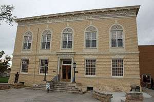 The Baca County Courthouse in Springfield. | |
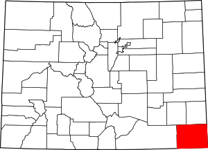 Location within the U.S. state of Colorado | |
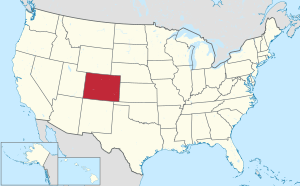 Colorado's location within the U.S. | |
| Coordinates: 37°19′N 102°34′W | |
| Country | |
| State | |
| Founded | April 16, 1889 |
| Named for | Felipe Baca |
| Seat | Springfield |
| Largest town | Springfield |
| Area | |
| • Total | 2,557 sq mi (6,620 km2) |
| • Land | 2,555 sq mi (6,620 km2) |
| • Water | 2.4 sq mi (6 km2) 0.09%% |
| Population (2010) | |
| • Total | 3,788[1] |
| • Density | 1.5/sq mi (0.6/km2) |
| Time zone | UTC−7 (Mountain) |
| • Summer (DST) | UTC−6 (MDT) |
| Congressional district | 4th |
| Website | bacacountyco |
History
Baca County was created by the Colorado legislature on April 16, 1889, out of eastern portions of Las Animas County. Baca County was named in honor of pioneer and Colorado territorial legislator Felipe Baca.
Prior to the 1880s there was little activity in the county, other than along the Cutoff Branch of the Santa Fe Trail that crosses its extreme southeastern corner. The 1910s saw wet years and expansion due to the increase in acreage that could be homesteaded. World War I also brought increased demand for agricultural products. The arrival of the Santa Fe Railroad in 1926 created new towns and a population increase.
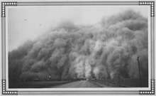
The Dust Bowl arrived in the 1930s, with Baca County being one of the hardest hit areas.[4] This prompted soil conservation efforts by the federal government. Part of this effort was the purchase of cultivated land by the government in order to return it to grassland. Today the U.S. Forest Service supervises 220,000 acres of Comanche National Grassland which was purchased in the 1930s. These areas include Carrizo Creek and Picture Canyon. The Colorado Division of Wildlife maintains the recreational areas at Two Buttes Lake and Turk's Pond.
On May 18, 1977, an F4 tornado struck the southeastern portion of Baca County, causing an estimated 2.5 million dollars in damage. It tracked from Keyes, Oklahoma, where damage was estimated between 25,000 dollars.[5] It was the first F4 tornado in Colorado since at least 1950.[6]
Geography
According to the U.S. Census Bureau, the county has a total area of 2,557 square miles (6,620 km2), of which 2,555 square miles (6,620 km2) is land and 2.4 square miles (6.2 km2) (0.09%) is water.[7]
Adjacent counties
- Prowers County, Colorado (north)
- Stanton County, Kansas (east/Central Time border)
- Morton County, Kansas (east/Central Time border)
- Cimarron County, Oklahoma (south/Central Time border)
- Union County, New Mexico (southwest)
- Las Animas County, Colorado (west)
- Bent County, Colorado (northwest)
National historic trail
- Santa Fe National Historic Trail
Demographics
| Historical population | |||
|---|---|---|---|
| Census | Pop. | %± | |
| 1890 | 1,479 | — | |
| 1900 | 759 | −48.7% | |
| 1910 | 2,516 | 231.5% | |
| 1920 | 8,721 | 246.6% | |
| 1930 | 10,570 | 21.2% | |
| 1940 | 6,207 | −41.3% | |
| 1950 | 7,964 | 28.3% | |
| 1960 | 6,310 | −20.8% | |
| 1970 | 5,674 | −10.1% | |
| 1980 | 5,419 | −4.5% | |
| 1990 | 4,556 | −15.9% | |
| 2000 | 4,517 | −0.9% | |
| 2010 | 3,788 | −16.1% | |
| Est. 2019 | 3,581 | [8] | −5.5% |
| U.S. Decennial Census[9] 1790-1960[10] 1900-1990[11] 1990-2000[12] 2010-2015[2] | |||
As of the census[13] of 2000, there were 4,517 people, 1,905 households, and 1,268 families residing in the county. The population density was 2 people per square mile (1/km²). There were 2,364 housing units at an average density of 1 per square mile (0/km²). The racial makeup of the county was 93.73% White, 0.04% Black or African American, 1.20% Native American, 0.15% Asian, 0.09% Pacific Islander, 2.99% from other races, and 1.79% from two or more races. 7.02% of the population were Hispanic or Latino of any race.
There were 1,905 households out of which 28.40% had children under the age of 18 living with them, 56.80% were married couples living together, 7.50% had a female householder with no husband present, and 33.40% were non-families. 30.40% of all households were made up of individuals and 15.70% had someone living alone who was 65 years of age or older. The average household size was 2.33 and the average family size was 2.90.
In the county, the population was spread out with 24.50% under the age of 18, 5.90% from 18 to 24, 22.70% from 25 to 44, 24.50% from 45 to 64, and 22.40% who were 65 years of age or older. The median age was 43 years. For every 100 females there were 99.00 males. For every 100 females age 18 and over, there were 95.50 males.
The median income for a household in the county was $28,099, and the median income for a family was $34,018. Males had a median income of $23,169 versus $18,292 for females. The per capita income for the county was $15,068. About 12.90% of families and 16.90% of the population were below the poverty line, including 21.60% of those under age 18 and 13.30% of those age 65 or over.
Infrastructure
The town is served by the Southeast Colorado Hospital.[14] Springfield Municipal Airport is located a few miles north of Springfield.
Politics
Like all of the High Plains, Baca County has long been overwhelmingly Republican. The last Democrat to carry the county was Lyndon Johnson in his 1964 landslide – when he carried all bar three Colorado counties – and since the "Reagan Revolution" only Michael Dukakis had exceeded thirty percent of the county's vote for the Democratic Party, whilst in 2016 Hillary Clinton received a mere thirteen percent.
| Year | Republican | Democratic | Others |
|---|---|---|---|
| 2016 | 81.4% 1,753 | 13.1% 283 | 5.4% 117 |
| 2012 | 74.0% 1,559 | 22.2% 467 | 3.8% 80 |
| 2008 | 72.3% 1,572 | 24.6% 536 | 3.1% 67 |
| 2004 | 76.9% 1,680 | 22.1% 483 | 1.1% 23 |
| 2000 | 73.0% 1,663 | 23.3% 531 | 3.7% 84 |
| 1996 | 59.5% 1,321 | 29.7% 659 | 10.8% 239 |
| 1992 | 47.3% 1,240 | 27.7% 726 | 25.0% 656 |
| 1988 | 65.3% 1,670 | 33.3% 851 | 1.4% 35 |
| 1984 | 75.9% 1,903 | 23.1% 580 | 1.0% 26 |
| 1980 | 74.3% 1,999 | 20.5% 551 | 5.3% 142 |
| 1976 | 52.0% 1,303 | 46.4% 1,164 | 1.6% 40 |
| 1972 | 73.9% 1,645 | 23.7% 527 | 2.4% 53 |
| 1968 | 57.6% 1,441 | 28.7% 719 | 13.7% 344 |
| 1964 | 47.4% 1,241 | 52.2% 1,366 | 0.4% 11 |
| 1960 | 65.5% 1,815 | 34.3% 952 | 0.2% 5 |
| 1956 | 59.6% 1,715 | 40.0% 1,150 | 0.4% 11 |
| 1952 | 65.6% 2,122 | 33.8% 1,094 | 0.6% 20 |
| 1948 | 47.5% 1,260 | 51.6% 1,368 | 0.9% 24 |
| 1944 | 61.9% 1,528 | 38.1% 941 | 0.0% 0 |
| 1940 | 56.5% 1,567 | 42.1% 1,167 | 1.4% 38 |
| 1936 | 39.5% 1,288 | 55.1% 1,797 | 5.5% 179 |
| 1932 | 34.0% 1,349 | 56.7% 2,247 | 9.3% 369 |
| 1928 | 78.5% 2,108 | 19.5% 524 | 2.0% 54 |
| 1924 | 46.4% 1,174 | 25.8% 653 | 27.9% 706 |
| 1920 | 63.2% 1,615 | 27.2% 695 | 9.6% 245 |
| 1916 | 35.0% 826 | 54.9% 1,294 | 10.1% 238 |
| 1912 | 28.2% 318 | 38.2% 430 | 33.6% 378 |
Communities
Unincorporated communities
See also
- Outline of Colorado
- Index of Colorado-related articles
- Colorado census statistical areas
- National Register of Historic Places listings in Baca County, Colorado
References
- "Population and Housing Unit Estimates". U.S. Census Bureau. August 15, 2017. Retrieved August 15, 2017.
- "State & County QuickFacts". United States Census Bureau. Archived from the original on July 28, 2011. Retrieved February 10, 2014.
- "Find a County". National Association of Counties. Archived from the original on 2011-05-31. Retrieved 2011-06-07.
- Laskin, David (December 17, 2005). "Laying Bare Dust Bowl's Scar Tissue". The New York Times. Retrieved 17 January 2014.
- "Event 9987497". Storm Events Database. National Climatic Data Center. Retrieved 2016-08-13.
- "Colorado EF4+ tornado search". Storm Events Database. National Climatic Data Center. Archived from the original on 2016-08-20. Retrieved 2016-08-13.
- "US Gazetteer files: 2010, 2000, and 1990". United States Census Bureau. 2011-02-12. Retrieved 2011-04-23.
- "Population and Housing Unit Estimates". Retrieved December 3, 2019.
- "U.S. Decennial Census". United States Census Bureau. Retrieved June 7, 2014.
- "Historical Census Browser". University of Virginia Library. Retrieved June 7, 2014.
- "Population of Counties by Decennial Census: 1900 to 1990". United States Census Bureau. Retrieved June 7, 2014.
- "Census 2000 PHC-T-4. Ranking Tables for Counties: 1990 and 2000" (PDF). United States Census Bureau. Retrieved June 7, 2014.
- "U.S. Census website". United States Census Bureau. Retrieved 2011-05-14.
- "About us". Southeast Colorado Hospital District. 2019. Retrieved 2019-03-14.
- Leip, David. "Dave Leip's Atlas of U.S. Presidential Elections". uselectionatlas.org. Retrieved May 26, 2017.
External links
| Wikimedia Commons has media related to Baca County, Colorado. |
- Official Baca County website
- Baca County History
- Colorado County Evolution by Don Stanwyck
- Colorado Historical Society
- Town of Campo official website
- Town of Springfield official website
- Town of Walsh official website
Places adjacent to Baca County, Colorado | |
|---|---|
Municipalities and communities of Baca County, Colorado, United States | ||
|---|---|---|
| Towns | Map of Colorado highlighting Baca County | |
| Unincorporated communities | ||

| Authority control |
|
|---|