Boulder County, Colorado
Boulder County is one of the 64 counties of the U.S. state of Colorado of the United States. As of the 2010 census, the population was 294,567.[2] The most populous municipality in the county and the county seat is Boulder.[3]
Boulder County | |
|---|---|
.jpg) Boulder County Courthouse | |
Seal | |
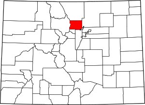 Location within the U.S. state of Colorado | |
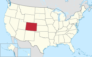 Colorado's location within the U.S. | |
| Coordinates: 40°05′N 105°22′W | |
| Country | |
| State | |
| Founded | November 1, 1861 |
| Named for | large granite boulders in area |
| Seat | Boulder |
| Largest city | Boulder |
| Area | |
| • Total | 740 sq mi (1,900 km2) |
| • Land | 726 sq mi (1,880 km2) |
| • Water | 14 sq mi (40 km2) 1.9%% |
| Population | |
| • Estimate (2019) | 326,196[1] |
| • Density | 450/sq mi (172/km2) |
| Time zone | UTC−7 (Mountain) |
| • Summer (DST) | UTC−6 (MDT) |
| Congressional districts | 2nd, 4th |
| Website | www |
Boulder County comprises the Boulder, CO Metropolitan Statistical Area, which is included in the Denver-Aurora, CO Combined Statistical Area.[4]
History
Boulder County was one of the original 17 counties created by the Territory of Colorado on November 1, 1861. The county was named for Boulder City and Boulder Creek, so named because of the abundance of boulders in the creek which hampered early gold prospecting efforts. Boulder County retains essentially the same borders as in 1861, although a 27.5 square miles (71.2 km2) of its southeastern corner and its approximate population of 40,000 became part of the City and County of Broomfield in 2001.
Before the arrival of the first US settlers, the area was occupied by American Indians led by Chief Niwot on the plains and seasonally by Utes in the mountains to the west. The first US settlers were gold prospectors led by Captain Thomas Aikins. His group of about twenty settled at the mouth of Boulder Creek Canyon on October 17, 1858. Chief Niwot told them not to stay and it is said they promised to move into the mountains to prospect in the spring. However in February 1859, they founded the town of Boulder. At about the same time, they also founded the first Gold Mining town in what would become Colorado, Gold Hill which is about 10 miles westerly from Boulder. Gold Hill was founded because of the placer gold discovered there. The area was the site of the first commercial scale placer mine in Colorado, producing over 5,500 ounces of gold in the first year of operations (1859).[5]
Geography
According to the U.S. Census Bureau, the county has a total area of 740 square miles (1,900 km2), of which 726 square miles (1,880 km2) is land and 14 square miles (36 km2) (1.9%) is water.[6]
Adjacent counties
- Larimer County, Colorado – north
- Weld County, Colorado – east
- City and County of Broomfield, Colorado – southeast
- Jefferson County, Colorado – south
- Gilpin County, Colorado – south
- Grand County, Colorado – west
National protected areas
Rocky Mountain National Park is in Boulder County, Larimer County, and Grand County. Longs Peak, the park's highest summit at 4,345 meters (14,255 feet) elevation, is located in Boulder County.
State protected area
Scenic trails and byways
- Continental Divide National Scenic Trail
- Peak to Peak Scenic and Historic Byway
Historic district
- Colorado Chautauqua National Historic District
Demographics
| Historical population | |||
|---|---|---|---|
| Census | Pop. | %± | |
| 1870 | 1,939 | — | |
| 1880 | 9,723 | 401.4% | |
| 1890 | 14,082 | 44.8% | |
| 1900 | 21,544 | 53.0% | |
| 1910 | 30,330 | 40.8% | |
| 1920 | 31,861 | 5.0% | |
| 1930 | 32,456 | 1.9% | |
| 1940 | 37,438 | 15.4% | |
| 1950 | 48,296 | 29.0% | |
| 1960 | 74,254 | 53.7% | |
| 1970 | 131,889 | 77.6% | |
| 1980 | 189,625 | 43.8% | |
| 1990 | 226,374 | 19.4% | |
| 2000 | 271,651 | 20.0% | |
| 2010 | 294,567 | 8.4% | |
| Est. 2019 | 326,196 | [7] | 10.7% |
| U.S. Decennial Census[8] 1790-1960[9] 1900-1990[10] 1990-2000[11] 2010-2015[2] | |||
As of the census[12] of 2000, there were 271,651 people, 114,680 households, and 68,808 families residing in the county. The population density was 392 people per square mile (151/km²). There were 119,900 housing units at an average density of 162 per square mile (62/km²). The racial makeup of the county was 88.54% White, 0.88% Black or African American, 0.61% Native American, 3.06% Asian, 0.06% Pacific Islander, 4.67% from other races, and 2.18% from two or more races. 10.46% of the population were Hispanic or Latino of any race.
There were 114,680 households out of which 30.70% had children under the age of 18 living with them, 48.90% were married couples living together, 7.70% had a female householder with no husband present, and 40.00% were non-families. 26.30% of all households were made up of individuals and 5.50% had someone living alone who was 65 years of age or older. The average household size was 2.47 and the average family size was 3.03.
In the county, the population was spread out with 22.90% under the age of 18, 13.40% from 18 to 24, 33.60% from 25 to 44, 22.30% from 45 to 64, and 7.80% who were 65 years of age or older. The median age was 33 years. For every 100 females, there were 102.20 males. For every 100 females age 18 and over, there were 101.70 males.
In 2014, the median income for a household in the county was $69,407, and the median income for a family was $94,938.[13] Males had a median income of $65,489 versus $48,140 for females. About 7.0% of families and 14.6% of the population were below the poverty line, including 14.6% of those under age 18 and 5.9% of those age 65 or over.
In 2017 Bloomberg ranked the Boulder metropolitan area as the top "brain" area in the US.[14]
Government
Boulder County is divided into three districts each represented by a commissioner elected county-wide. The three commissioners comprise the county Board of Commissioners and represent the county as a whole. Each commissioner must reside in their respective district and may be elected to a maximum of two four-year terms.
The Board of County Commissioners are full-time public servants and approve the budget for the entire County government. The Board also oversees the management of 10 County departments and the daily operations of the county, work that is done by a county manager or a chief administrative officer in some counties.
Boulder County has seven other county-wide elected officials, including the District Attorney, who represents the 20th Judicial District.[15]
Elected officials
| Name | Office | Year Term Began | Year Re-Elected |
|---|---|---|---|
| Deb Gardner | County Commissioner | 2012[lower-alpha 1] | 2016 |
| Elise Jones | County Commissioner | 2012 | 2016 |
| Cindy Domenico | County Commissioner | 2007[lower-alpha 2] | 2010 |
| Jerry Roberts | Assessor | 2007[lower-alpha 3] | 2010 |
| Hillary Hall[lower-alpha 4] | Clerk and Recorder | 2006 | 2010 |
| Emma R. Hall[lower-alpha 4] | Coroner | 2010 | 2014 |
| Stanley L. Garnett | District Attorney | 2008 | 2012 |
| Joe Pelle | Sheriff | 2002 | 2006, 2010, 2014 |
| Lee Stadele | Surveyor | 2014 | |
| Paul Weissmann | Treasurer | 2014 |
- Deb Gardner of Longmont was appointed to the Boulder County Board of Commissioners by a majority vote of a Boulder County Democratic Party vacancy committee on January 8, 2012, and was sworn into office on January 10 replacing Ben Pearlman who resigned as commissioner on January 1, 2012 after being selected to head the County Attorney’s office.
- Incumbent Ton Mayer died, and Cindy Domenico was appointed in July 2007 to fill the vacant seat. In 2008, voters elected Domenico to complete the remainder of the term that continued through 2010.
- Incumbent Cindy Domenico resigned after being elected to the post of Boulder County Commissioner. Jerry Roberts was appointed to fill the vacant seat in July 2007. In 2008, voters elected Roberts to complete the remainder of the term that continued through 2010.
- Hillary Hall and Emma Hall are not related.
Politics
As of June 2013, Boulder County is regarded as one of the most liberal counties in Colorado. Republicans took less than 28% of the vote in Boulder County in both 2008 and 2012 and took only 22% in 2016.
In 2000, Green Party presidential candidate Ralph Nader took 11.82% of the vote in Boulder County, more than twice the 5.25% he took statewide in Colorado, and more than four times his 2.73% nationwide vote share.[16]
| Year | Republican | Democratic | Others |
|---|---|---|---|
| 2016 | 22.0% 41,396 | 70.3% 132,334 | 7.7% 14,415 |
| 2012 | 27.8% 49,981 | 69.7% 125,091 | 2.5% 4,427 |
| 2008 | 26.1% 44,904 | 72.3% 124,159 | 1.6% 2,700 |
| 2004 | 32.4% 51,586 | 66.3% 105,564 | 1.3% 2,109 |
| 2000 | 36.4% 50,873 | 50.1% 69,983 | 13.5% 18,770 |
| 1996 | 34.6% 41,922 | 52.2% 63,316 | 13.3% 16,116 |
| 1992 | 26.5% 33,553 | 50.9% 64,567 | 22.6% 28,651 |
| 1988 | 44.9% 48,174 | 53.4% 57,265 | 1.7% 1,784 |
| 1984 | 55.1% 53,535 | 43.4% 42,195 | 1.5% 1,493 |
| 1980 | 46.7% 40,698 | 32.6% 28,422 | 20.6% 17,949 |
| 1976 | 52.7% 42,830 | 41.0% 33,284 | 6.3% 5,139 |
| 1972 | 56.8% 40,766 | 41.1% 29,484 | 2.1% 1,520 |
| 1968 | 57.7% 27,671 | 36.3% 17,422 | 6.0% 2,895 |
| 1964 | 43.1% 17,373 | 56.4% 22,737 | 0.6% 220 |
| 1960 | 61.5% 19,791 | 38.1% 12,276 | 0.4% 130 |
| 1956 | 66.9% 16,748 | 32.6% 8,149 | 0.6% 142 |
| 1952 | 65.3% 15,069 | 33.7% 7,767 | 1.1% 243 |
| 1948 | 52.1% 10,335 | 44.3% 8,792 | 3.6% 712 |
| 1944 | 57.1% 10,054 | 42.3% 7,442 | 0.7% 114 |
| 1940 | 53.2% 10,525 | 45.7% 9,039 | 1.1% 212 |
| 1936 | 41.4% 7,244 | 55.9% 9,788 | 2.7% 469 |
| 1932 | 44.8% 7,487 | 50.4% 8,412 | 4.8% 808 |
| 1928 | 67.5% 9,457 | 31.1% 4,363 | 1.4% 195 |
| 1924 | 58.8% 7,595 | 25.3% 3,273 | 15.9% 2,059 |
| 1920 | 57.9% 6,456 | 37.7% 4,200 | 4.4% 492 |
| 1916 | 33.0% 3,986 | 61.5% 7,419 | 5.5% 666 |
| 1912 | 23.0% 2,445 | 40.8% 4,330 | 36.2% 3,845 |
Boulder County has also demonstrated its liberal leanings in referenda on social issues, such as in 2006, when nearly 2/3 of Boulder County voters voted to reject Amendment 43, a constitutional amendment defining marriage as between one man and one woman. Although the amendment passed statewide with 55% of the vote, only 33% of Boulder County supported it.[18] In 2012, over 66% of Boulder County voted in favor of Amendment 64, legalizing marijuana in the state of Colorado.
Local courts
The 20th Judicial District of Colorado, the state trial court of general jurisdiction, serves and is coextensive with Boulder County. As of 2009 the 20th Judicial Circuit has eight District Court judges. The Boulder County Court, the state trial court of limited jurisdiction, consists of five judges and six magistrates.
Boulder County has two combined courthouses:
- The Boulder County Justice Center is located in the City of Boulder and is headquarters to the 20th Judicial District of Colorado. The office of the district attorney is also here, as is the Juvenile Assessment Center, the county's combined assessment and detention facility.
- The Longmont Courthouse in the City of Longmont acts as an extension of the County Court and the District Attorney's Office.[19]
Communities
Cities
- Boulder
- Lafayette
- Longmont (partly in Weld County)
- Louisville
Towns
- Erie (partly in Weld County)
- Jamestown
- Lyons
- Nederland
- Superior (partly in Jefferson County)
- Town of Ward
Census-designated places
- Allenspark
- Altona
- Bark Ranch
- Bonanza Mountain Estates
- Coal Creek (partly in Gilpin County and Jefferson County)
- Crisman
- Eldora
- Eldorado Springs
- Glendale
- Gold Hill
- Gunbarrel
- Hidden Lake
- Lazy Acres
- Leyner
- Mountain Meadows
- Niwot
- Paragon Estates
- Pine Brook Hill
- Seven Hills
- St. Ann Highlands
- Sugarloaf
- Sunshine
- Tall Timber
- Valmont
- Wondervu
See also
References
- "Population and Housing Unit Estimates". U.S. Census Bureau. August 15, 2017. Retrieved August 15, 2017.
- "State & County QuickFacts". United States Census Bureau. Retrieved June 7, 2014.
- "Find a County". National Association of Counties. Archived from the original on May 31, 2011. Retrieved 2011-06-07.
- "OMB Bulletin No. 10-02: Update of Statistical Area Definitions and Guidance on Their Uses" (PDF). United States Office of Management and Budget. December 1, 2009. Archived from the original (PDF) on March 16, 2012. Retrieved April 19, 2012.
- Jerome Constant Smiley (1913). Semi-centennial History of the State of Colorado. Brookhaven Press. pp. 219–. ISBN 978-1-4035-0045-8.
- "US Gazetteer files: 2010, 2000, and 1990". United States Census Bureau. February 12, 2011. Retrieved April 23, 2011.
- "U.S. Census website". Retrieved March 23, 2018.
- "U.S. Decennial Census". United States Census Bureau. Retrieved June 7, 2014.
- "Historical Census Browser". University of Virginia Library. Retrieved June 7, 2014.
- "Population of Counties by Decennial Census: 1900 to 1990". United States Census Bureau. Retrieved June 7, 2014.
- "Census 2000 PHC-T-4. Ranking Tables for Counties: 1990 and 2000" (PDF). United States Census Bureau. Retrieved June 7, 2014.
- "U.S. Census website". United States Census Bureau. Retrieved 2011-05-14.
- "U.S. Census website". United States Census Bureau. Retrieved March 23, 2016.
- Vincent Del Giudice, Wei Lu, and Agnel Philip (October 10, 2017). "The Smartest Americans Are Heading West". Retrieved October 11, 2017 – via www.bloomberg.com.CS1 maint: uses authors parameter (link)
- "Boulder County Board of County Commissioners". Boulder County. Archived from the original on December 10, 2007. Retrieved December 1, 2009.
- "Dave Leip's Atlas of U.S. Presidential Elections". Retrieved January 5, 2013.
- Leip, David. "Dave Leip's Atlas of U.S. Presidential Elections". uselectionatlas.org. Retrieved May 26, 2017.
- "Dave Leip's Atlas of U.S. Presidential Elections". Retrieved January 5, 2013.
- "20th Judicial District/Boulder County". Colorado State Courts. Archived from the original on January 27, 2010. Retrieved December 1, 2009.
External links
- Boulder County Government website
- Boulder County USGenWeb
- Colorado County Evolution by Don Stanwyck
- Colorado Historical Society
- Rocky Mountain National Park website
Places adjacent to Boulder County, Colorado | ||||||||||
|---|---|---|---|---|---|---|---|---|---|---|
| ||||||||||
Municipalities and communities of Boulder County, Colorado, United States | ||
|---|---|---|
| Cities | Map of Colorado highlighting Boulder County | |
| Towns | ||
| CDPs | ||
| Unincorporated communities | ||
| Ghost town | ||
| Footnotes | ‡This populated place also has portions in an adjacent county or counties | |

| Authority control |
|
|---|