Loveland, Colorado
Loveland is the Home Rule Municipality that is the second most populous municipality in Larimer County, Colorado, United States. Loveland is situated 46 miles (74 km) north of the Colorado State Capitol in Denver and is the 14th most populous city in Colorado. As of the 2010 census the population of Loveland was 66,859,[8] and in 2019 the population was estimated at 78,877.[6] The city forms part of the Fort Collins-Loveland Metropolitan Statistical Area and the Front Range Urban Corridor. The city's public schools are part of the Thompson R2-J School District.
Loveland, Colorado | |
|---|---|
 | |
 Flag | |
| Nickname(s): The Sweetheart City | |
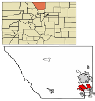 Location in Larimer County, Colorado | |
| Coordinates: 40°24′17″N 105°5′9″W | |
| Country | United States |
| State | Colorado |
| County[1] | Larimer |
| Founded | 1877 |
| Incorporated | April 30, 1881[2] |
| Named for | William A.H. Loveland |
| Government | |
| • Type | Home Rule Municipality[1] |
| • Mayor | Jacki Marsh |
| • Mayor pro tem | Don Overcash |
| • City Manager | Steve Adams |
| Area | |
| • Total | 35.56 sq mi (92.11 km2) |
| • Land | 34.09 sq mi (88.29 km2) |
| • Water | 1.47 sq mi (3.81 km2) 4.13% |
| Elevation | 4,982 ft (1,519 m) |
| Population | |
| • Total | 66,859 |
| • Estimate (2019)[6] | 78,877 |
| • Density | 2,271.9/sq mi (877.18/km2) |
| Time zone | UTC−7 (MST) |
| • Summer (DST) | UTC−6 (MDT) |
| ZIP codes[7] | 80534, 80537-80539 |
| Area code(s) | 970 |
| FIPS code | 08-46465 |
| GNIS feature ID | 0177720 |
| Highways | I-25, US 34, US 287, SH 60, SH 402 |
| Website | www |
Location
Loveland is located in southeastern Larimer County at 40°24′17″N 105°5′9″W (40.404789, −105.085868).[9]
Located south of Fort Collins, its larger neighbor and the county seat of Larimer County, both cities have expanded steadily towards each other over the last several decades and are considered a single metropolitan area by the U.S. government. The establishment of county-owned open space between the two communities in the 1990s was intended to create a permanent buffer between them. The northern city limits are now contiguous with those of Windsor, which has expanded westward from Weld County across Interstate 25. Loveland has aggressively expanded its incorporated limits eastward to embrace the interchange of Interstate 25 and U.S. Highway 34, and is currently developing the area. In the last decade, the intersection has become a primary commercial hub of northern Colorado, with the construction of shopping centers and the Budweiser Events Center. A new medical center[10] and mall[11] have also been built at the I-25/US-34 interchange. This area is known as Centerra. The interchange is shared with its smaller neighbor Johnstown, of Weld County.
History
Mariano Medina built the first settlement in the area, Fort Namaqua, in 1858.[12] It was a trading post and stage station, and the site is now Namaqua Park.[13] Prior to that time it was a hub for French fur trappers dating back to the late 1700s.[14]
The city was officially founded in 1877[15] along the newly constructed line of the Colorado Central Railroad, near its crossing of the Big Thompson River. It was named in honor of William A.H. Loveland,[14] the president of the Colorado Central Railroad. The city was founded one mile (1.6 km) upstream from the existing small settlement of St. Louis, the buildings of which were moved to the site of Loveland. For the first half of the 20th century the town was dependent on agriculture. The primary crops in the area were sugar beets and sour cherries. In 1901 the Great Western Sugar Company built a factory in Loveland, which remained as a source of employment until its closure in 1977. During the late 1920s the Spring Glade Orchard was the largest cherry orchard west of the Mississippi River. At that time the cherry orchards produced more than $1 million worth of cherries per year. A series of droughts, attacks of blight and finally a killer freeze destroyed the industry. By 1960 cherries were no longer farmed. In the late 20th century, the economy diversified with the arrival of manufacturing facilities by Hewlett-Packard, Teledyne, and Hach, a water quality analysis equipment manufacturer. A new medical center has added a substantial amount of employment in that sector as well.
On September 12, 2013, a historic flood affected numerous areas in Colorado. It rained heavily for four consecutive days, causing most rivers and creeks to overfill their banks. Estes Park received 8 to 12 inches (200 to 300 mm) of rain, causing Lake Estes to overfill its banks. This prompted a lot of water to be released out of the dam, causing the Big Thompson River to swell. The flooding river caused sections of U.S. Highway 34, the main highway from Loveland to Estes Park, to collapse. The Big Thompson caused major flooding in Loveland, and caused numerous road closures because of flood waters. The Loveland/Fort Collins area received about 4 inches (100 mm), which is relatively less significant compared to the amount of rain other places received. This flood is often compared to the Big Thompson Flood of 1976. It also being called a 500-year flood. Five[16] people were killed in the floods from the Cedar Cove neighborhood in the Big Thompson River Canyon.
Geography and climate
According to the United States Census Bureau, the city has a total area of 25.5 square miles (66 km2), of which 24.6 square miles (64 km2) is land, and 0.9 square miles (2.3 km2) (3.68%) is water.
Though often mistaken, Loveland Pass, also named after William A.H. Loveland, is not located near the town of Loveland.
Loveland has a semi-arid climate (Köppen climate classification BSk).
Loveland, Colorado has an annual snowfall of 54 inches (1,400 mm).
| Climate data for Loveland, Colorado | |||||||||||||
|---|---|---|---|---|---|---|---|---|---|---|---|---|---|
| Month | Jan | Feb | Mar | Apr | May | Jun | Jul | Aug | Sep | Oct | Nov | Dec | Year |
| Average high °F (°C) | 42 (6) |
47 (8) |
54 (12) |
61 (16) |
71 (22) |
81 (27) |
86 (30) |
84 (29) |
77 (25) |
65 (18) |
51 (11) |
44 (7) |
64 (18) |
| Average low °F (°C) | 14 (−10) |
19 (−7) |
26 (−3) |
33 (1) |
43 (6) |
51 (11) |
57 (14) |
55 (13) |
46 (8) |
35 (2) |
23 (−5) |
16 (−9) |
35 (2) |
| Average precipitation inches (mm) | 0.38 (9.7) |
0.37 (9.4) |
1.28 (33) |
1.75 (44) |
2.26 (57) |
1.87 (47) |
1.55 (39) |
1.18 (30) |
1.42 (36) |
0.95 (24) |
0.70 (18) |
0.27 (6.9) |
13.98 (355) |
| Source: Weather.com[17] | |||||||||||||
Neighboring towns
Places adjacent to Loveland, Colorado | ||||||||||
|---|---|---|---|---|---|---|---|---|---|---|
| ||||||||||
Demographics
| Historical population | |||
|---|---|---|---|
| Census | Pop. | %± | |
| 1880 | 236 | — | |
| 1890 | 698 | 195.8% | |
| 1900 | 1,091 | 56.3% | |
| 1910 | 3,651 | 234.6% | |
| 1920 | 5,065 | 38.7% | |
| 1930 | 5,506 | 8.7% | |
| 1940 | 6,145 | 11.6% | |
| 1950 | 6,773 | 10.2% | |
| 1960 | 9,734 | 43.7% | |
| 1970 | 16,220 | 66.6% | |
| 1980 | 30,215 | 86.3% | |
| 1990 | 37,352 | 23.6% | |
| 2000 | 50,608 | 35.5% | |
| 2010 | 66,859 | 32.1% | |
| Est. 2019 | 78,877 | [6] | 18.0% |
| U.S. Decennial Census[18] | |||
As of the census of 2000, there were 50,608 people, 19,741 households, and 14,035 families residing in the city. The population density was 2,059.7 people per square mile (795.3/km²). There were 20,299 housing units at an average density of 826.2 per square mile (319.0/km²). The racial makeup of the city was 92.85% White, 0.37% Black, 0.69% Native American, 0.83% Asian, 0.03% Pacific Islander, 3.21% from other races, and 2.02% from two or more races. Hispanic or Latino of any race were 8.57% of the population.
There were 19,741 households out of which 35.3% had children under the age of 18 living with them, 57.5% were married couples living together, 9.8% had a female householder with no husband present, and 28.9% were non-families. 23.4% of all households were made up of individuals and 8.8% had someone living alone who was 65 years of age or older. The average household size was 2.55 and the average family size was 3.01.
In the city, the population was spread out with 26.9% under the age of 18, 7.8% from 18 to 24, 30.6% from 25 to 44, 22.1% from 45 to 64, and 12.5% who were 65 years of age or older. The median age was 36 years. For every 100 females, there were 96.1 males. For every 100 females age 18 and over, there were 92.4 males.
The median income for a household in the city was $47,119, and the median income for a family was $54,337. Males had a median income of $38,971 versus $26,714 for females. The per capita income for the city was $21,889. About 4.0% of families and 5.7% of the population were below the poverty line, including 6.7% of those under age 18 and 5.0% of those age 65 or over.
Law and government
| Mayor | Jackie Marsh |
| Ward 1 | Jeremy Jersvig |
| Ward 1 | Richard Ball |
| Ward 2 | Kathi Wright |
| Ward 2 | Leah Johnson |
| Ward 3 | John Fogle |
| Ward 3 | Steven Olson |
| Ward 4 | Dave Clark |
| Ward 4 | Don Overcash Mayor "Pro Tem" |
The City of Loveland is a home-rule, council-manager form of government. The city council is a nine-member policy-making board, led by the mayor, who is elected for a two-year term by the community at large.
The mayor has the same voting rights as all other council members and is responsible for presiding over council meetings. This position is recognized as the city government leader for all ceremonial purposes. The council elects, by majority vote, a mayor pro tem to serve the same term as the mayor. The mayor pro tem is expected to perform responsibilities of the mayor when he or she is absent or unable to perform their duties.
Two council members are elected from each ward to serve four-year terms. There are four wards in the city. The council member representing the ward must have lived in the ward for 12 consecutive months immediately preceding the election.[20]
Loveland is represented in Congress by Representative Joe Neguse (Democrat). On the state level, the city lies in the 15th district of the Colorado Senate, represented by Kevin Lundberg, and in the 51st district of the Colorado House of Representatives, represented by Hugh McKean. Both of Loveland's state legislators are Republicans.
Education
Continuing education
- Aims Community College
- Colorado Christian University (Northern Colorado Center satellite site)
- William Loveland College
High schools
Middle schools
Elementary schools
- B.F. Kitchen Elementary School
- Big Thompson Elementary School
- Carrie Martin Elementary School
- Centennial Elementary School
- Cottonwood Plains Elementary School
- High Plains School (K-8)
- Laurene Edmondson Elementary School
- Lincoln Elementary School
- Mary Blair Elementary School
- Monroe Elementary School
- Namaqua Elementary School
- New Vision Charter School
- Ponderosa Elementary School
- Sarah Milner Elementary School
- Stansberry Elementary School
- Truscott Elementary School
- Winona Elementary School
- Van Buren Elementary School
- Garfield Elementary School
Private schools
Transportation

The Fort Collins / Loveland Airport serves corporate and general aviation needs, but does not currently have commercial airline service. The closest commercial/commuter airport is Denver International Airport, 70 miles (110 km) to the south, which is served by nearly twenty airlines. Loveland can be approached from Denver by car via Interstate 25. Hourly shared shuttle services to and from DIA are also offered by Green Ride Colorado and Red Lion to reach the Loveland and Fort Collins area.
U.S. Highway 34 runs east to west into the mountains through Loveland. It becomes Eisenhower Boulevard in the city, dividing it in half. Loveland's two main ZIP Codes (80538 and 80537) are separated by this highway. A Tesla Supercharger was built and operational in the city by the end of December 2016.
The city bus system in Loveland is called COLT—City of Loveland Transit.
Loveland is connected to Fort Collins, Berthoud, and Longmont via the FLEX regional bus route[21] and to Denver via the Bustang interregional express bus.[22]
Media
Places of interest
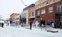
The Fort Collins-Loveland metropolitan area has received numerous awards as a great place to live, by Money Magazine, USA Today, AARP the Magazine, and others. There is a large population of artists in Loveland, which has drawn three foundries, an art museum, and the annual sculpture shows in August. The city is a major business center for northern Colorado.
The city is located in the Colorado Front Range region at the base of the foothills just east of the mouth of Big Thompson River Canyon at the intersection of U.S. Highway 34 and U.S. Highway 287. Longs Peak and other mountains of the Front Range are visible from much of the city. Lake Loveland, an early agricultural reservoir in the irrigation system of the region, is located in the city limits and provides a recreational facility for the city residents.
Because of its location along U.S. 34, at one of the principal access routes to Estes Park and Rocky Mountain National Park, Loveland receives a significant amount of pass-through tourist traffic, especially in the summer months. In addition, the city serves as a "bedroom" community to commuters in many directions: to employment locations in Boulder, Westminster and other parts of the Denver Metropolitan area; and also to the college towns of Fort Collins (CSU), Greeley (UNC), and Boulder, (CU).
Valentine Re-Mailing Program
Loveland is the home of the Valentine Re-Mailing Program. For decades people from across the world have sent their valentines to Loveland, Colorado, to be hand-stamped with a cachet and verse, and a specially designed postal cancelation. A new verse and stamp are selected each year through a contest held by the Loveland Chamber of Commerce and residents can submit their poems and artwork to be judged. On average, this program re-mails more than 160,000 cards from the United States and more than 110 countries. Loveland's Valentine Re-mailing Program has inspired many other Valentine's Day programs including the Official Loveland Valentine, Miss Loveland Valentine and the Thompson Valley Rotary Heart's Program.
Loveland's Valentine Re-mailing Program began in January 1947 by Ted Thompson and Elmer Ivers, the Loveland postmaster after Ivers received about 30 valentines from individuals requesting to have the cards postmarked from Loveland for "a romantic extra touch." The two thought re-mailing valentines would be an opportunity to advertise Loveland, and the Loveland Chamber of Commerce agreed to promote the service. Thompson designed a cachet with the message, "A Valentine Greeting from Sweetheart Town, Loveland, Colorado," and the image was a heart pierced by an arrow over the Rocky Mountains. The cachet was used twice, then Thompson started the tradition of changing it each year at the request of collectors. Since then, a different verse and design have been used every year.
In addition to the mailing program, community members can pay to purchase a large valentine message on wooden hearts that are displayed on the streets across Loveland. Many of these public valentines are engagement proposals, anniversary messages, and annual traditions.
Public arts program
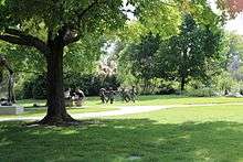
Loveland has 475 pieces of art in its public arts collection. The arts collection consists primarily of sculpture; however, the collection also includes murals and other flat work. Over 150 pieces of the city's sculpture can be found in Loveland's Benson Sculpture Garden.[23]
The Sculpture in the Park show, hosted by the Loveland High Plains Arts Council, takes place annually in August and exhibits artwork from artists from the United States and the world.
Notable people
- Wayne Allard, former U.S. Senator from Colorado
- Jeremy Bloom, Olympic skier; former wide receiver and punt returner at the University of Colorado; drafted by the Philadelphia Eagles in 2006
- Jeff Byers, offensive guard for University of Southern California and the NFL's Carolina Panthers
- Alexi Grewal, Olympic gold medal winning cyclist
- Meredith Hodges, equine trainer and author
- Kyle Howard, actor
- Collin Klein, former starting quarterback for Kansas State University and Heisman Trophy finalist
- Jeff Lucas, writer/broadcaster
- Don Marostica, Colorado Director of Economic Development
- Marilyn Martinez, comic
- Scot McCloughan, former general manager of the Washington Redskins
- James Niehues, panoramic illustrator famous for his ski area trail maps
See also
- Loveland Chamber of Commerce
- Outline of Colorado
- State of Colorado
- Colorado cities and towns
- Colorado municipalities
- Colorado counties
- Colorado metropolitan areas
- Front Range Urban Corridor
- North Central Colorado Urban Area
- Fort Collins-Loveland, CO Metropolitan Statistical Area
- Colorado cities and towns
- Medical Center of the Rockies
References
- "Active Colorado Municipalities". Colorado, Department of Local Affairs. Archived from the original on 2009-12-12. Retrieved 2007-09-01.
- "Colorado Municipal Incorporations". Colorado, Department of Personnel & Administration, Colorado State Archives. 2004-12-01. Retrieved 2007-09-02.
- "2016 U.S. Gazetteer Files". United States Census Bureau. Retrieved Jul 25, 2017.
- "US Board on Geographic Names". United States Geological Survey. 2007-10-25. Retrieved 2008-01-31.
- "U.S. Census website". United States Census Bureau. Retrieved 2015-02-11.
- "Population and Housing Unit Estimates". Retrieved May 21, 2020.
- "ZIP Code Lookup". United States Postal Service. Archived from the original (JavaScript/HTML) on 2010-11-22. Retrieved 2007-11-15.
- "Geographic Identifiers: 2010 Census Summary File 1 (G001), Loveland city, Colorado". American FactFinder. U.S. Census Bureau. Archived from the original on February 13, 2020. Retrieved September 11, 2019.
- "US Gazetteer files: 2010, 2000, and 1990". United States Census Bureau. 2011-02-12. Retrieved 2011-04-23.
- McKee Medial Center
- The Promenade Shops at Centerra
- Paul T. Hellmann (February 14, 2006). Historical Gazetteer of the United States. Routledge. p. 1942. ISBN 1-135-94858-5.
- From the Grave: A Roadside Guide to Colorado's Pioneer Cemeteries. Caxton Press. p. 217. ISBN 978-0-87004-565-3.
- Gannett, Henry (1905). The Origin of Certain Place Names in the United States. U.S. Government Printing Office. p. 191.
- http://www.cityofloveland.org/about
- Family member - dear friend
- Weather.com—. Retrieved 31 July 2010.
- "Census of Population and Housing". Census.gov. Retrieved June 4, 2015.
- "Home page for city council". City of Loveland. Archived from the original on April 7, 2015. Retrieved April 7, 2015.
- "City of Loveland City Council". Retrieved 8 April 2015.
- http://www.cityofloveland.org/index.aspx?page=250
External links
| Wikimedia Commons has media related to Loveland, Colorado. |
| Wikivoyage has a travel guide for Loveland, Colorado. |
- Official website
- CDOT map of the City of Loveland
- COLT — City of Loveland Transit
- Loveland Chamber of Commerce
- Loveland Reporter-Herald
- Visit Loveland
Municipalities and communities of Larimer County, Colorado, United States | ||
|---|---|---|
| Cities | 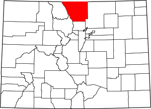 Map of Colorado highlighting Larimer County | |
| Towns | ||
| CDPs | ||
| Unincorporated communities | ||
| Ghost towns | ||
| Footnotes | ‡This populated place also has portions in an adjacent county or counties | |

| Authority control |
|
|---|