Hoehne, Colorado
Hoehne is an unincorporated community and census-designated place (CDP) in Las Animas County, Colorado, United States. As of the 2010 census, it had a population of 111.[2] Hoehne has a post office with the ZIP Code 81046.[3]
Hoehne, Colorado | |
|---|---|
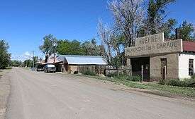 County Road 40.6 in Hoehne | |
 Location in Las Animas County, Colorado | |
 Hoehne Location in the United States | |
| Coordinates: 37°16′52″N 104°22′49″W | |
| Country | |
| State | |
| County | Las Animas[1] |
| Area | |
| • Total | 3.11 sq mi (8.05 km2) |
| • Land | 3.11 sq mi (8.05 km2) |
| • Water | 0.0 sq mi (0.0 km2) |
| Elevation | 5,740 ft (1,750 m) |
| Population (2010) | |
| • Total | 111 |
| • Density | 36/sq mi (13.8/km2) |
| [2] | |
| Time zone | UTC-7 (MST) |
| • Summer (DST) | UTC-6 (MDT) |
| ZIP code[3] | 81046 |
| Area code(s) | 719 |
| FIPS code | 08-36940 |
History
Hoehne was founded by German immigrant William Hoehne in 1859. He is credited with founding the Hoehne Ditch Company and introducing the first mill and threshing machine into the area.[4] William Hoehne farmed 1,000 acres (400 ha), planting strawberries, apples, and cherries. Hoehne is still a farming community, but the focus has shifted from fruits to alfalfa and grass hay.
The population of Hoehne today is slightly more than 100 people. But during its heyday, the town boasted a hotel, a train depot called "Hoehnes", a blacksmith, a Catholic church, and several stores. The train depot was retired in 1967 and was moved twice - the second time to its current location in Texas Creek, where it was restored to its original condition.[5] The Hoehnes train depot sign is still visible today at the original depot location.
Hoehne is located near the Santa Fe Trail, and a historical marker is located approximately one mile north of the town on County Road 42.0.
Geography
Hoehne is located in west-central Las Animas County at 37°16′52″N 104°22′49″W (37.281156,-104.380245), on high ground north of the Purgatoire River. It is 11 miles (18 km) northeast of Trinidad, the county seat. According to the U.S. Census Bureau, the Hoehne CDP has an area of 3.1 square miles (8.0 km2), all of it land.[2]
See also
- Outline of Colorado
- State of Colorado
- Colorado cities and towns
- Colorado census designated places
- Colorado counties
- Colorado cities and towns
References
- "US Board on Geographic Names". United States Geological Survey. 2007-10-25. Retrieved 2008-01-31.
- "Geographic Identifiers: 2010 Census Summary File 1 (G001), Hoehne CDP, Colorado". American FactFinder. U.S. Census Bureau. Archived from the original on February 13, 2020. Retrieved September 17, 2019.
- "ZIP Code Lookup". United States Postal Service. December 28, 2006. Archived from the original (JavaScript/HTML) on November 23, 2010. Retrieved December 28, 2006.
- MacArthur, Mildred Sherwood. A History of the German element in the state of Colorado. Cornell University, 1914, p.24.
- Werkema, Evan. "Santa Fe Surviving Depots: Colorado". Last revised October 4, 2004.
- "Census of Population and Housing". Census.gov. Retrieved June 4, 2016.
Municipalities and communities of Las Animas County, Colorado, United States | ||
|---|---|---|
| City | 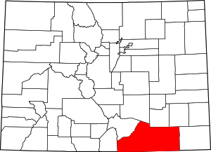 Map of Colorado highlighting Las Animas County | |
| Towns | ||
| CDPs | ||
| Unincorporated communities | ||
| Ghost towns | ||