Metro Iloilo–Guimaras
| Metropolitan Iloilo–Guimaras Kaulohan nga Iloilo–Guimaras Kalakhang Iloilo–Guimaras | ||
|---|---|---|
| Metropolitan area | ||
| ||
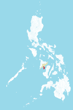 Map of Metro Iloilo–Guimaras (in red) including the province of Iloilo highlighted in light orange. | ||
| Coordinates: 10°43′N 122°34′E / 10.72°N 122.57°ECoordinates: 10°43′N 122°34′E / 10.72°N 122.57°E | ||
| Country | Philippines | |
| Region | Western Visayas (Region VI) | |
| Province | Iloilo and Guimaras | |
| Area | ||
| • Total | 1,105.53 km2 (426.85 sq mi) | |
| Population (2015 census)[1] | ||
| • Total | 946,146 | |
| • Density | 860/km2 (2,200/sq mi) | |
| Time zone | UTC+8 (PST) | |
| Languages | Hiligaynon, Kinaray-a, Filipino, English | |
| Website |
www | |
The Iloilo–Guimaras Metropolitan Area or Metro Iloilo–Guimaras (MIG) (Hiligaynon: Kaulohan nga Iloilo–Guimaras; Filipino: Kalakhang Iloilo–Guimaras) is a metropolitan area encompassing the highly urbanized city of Iloilo City, the Regional Agro-Industrial Center of Pavia, the towns of Oton, Leganes, Santa Barbara, Cabatuan and San Miguel and the neighboring island province of Guimaras with its five municipalities of Jordan, Buenavista, Nueva Valencia, San Lorenzo and Sibunag.
Ranked number sixth in terms of population among the twelve metropolitan areas in the Philippines and it ranked fifth in terms of land area.
Metro Iloilo - Guimaras is the only officially recognized metropolitan area in Western Visayas as per Presidential Executive Order No. 559 duly signed by President Gloria Macapagal Arroyo on August 28, 2006.
Cities and municipalities
It comprises one highly urbanized city and six municipalities in Iloilo Province and five municipalities in Guimaras Province.[2]
| City | Population (2015)[1] | Area (km²) | Pop. density (per km2) | Income Class |
|---|---|---|---|---|
| Iloilo City | 447,992 | 78.34 | 5,719 | 1st Class; Highly Urbanized |
| Oton | 89,115 | 86.44 | 1,031 | 1st Class |
| Pavia | 55,603 | 27.15 | 2,048 | 2nd Class |
| Leganes | 32,480 | 32.20 | 1,009 | 4th Class |
| Santa Barbara | 60,215 | 131.96 | 456 | 1st Class |
| Cabatuan | 58,442 | 112.90 | 518 | 2nd Class |
| San Miguel | 27,686 | 31.97 | 866 | 4th Class |
| Jordan | 36,096 | 126.11 | 286 | 3rd Class |
| Buenavista | 50,437 | 128.26 | 393 | 2nd Class |
| Nueva Valencia | 39,810 | 137.12 | 290 | 3rd Class |
| San Lorenzo | 26,112 | 93.04 | 281 | 5th Class |
| Sibunag | 22,158 | 120.04 | 185 | 5th Class |
| Total | 946,146 | 1,105.53 | 856 |
Infrastructure developments
Roads
The Sen. Benigno S. Aquino Jr. Avenue, Mc Arthur Drive, Cong. Narciso Monfort Boulevard, Gen. Luna Street, CJ Ramon Avancena Street, E. Lopez Street, Pres. Corazon C. Aquino Avenue, Iznart Street and Mulle Loney Drive are Metro Iloilo's major roads. The Sen. Benigno S. Aquino Jr. Avenue was renovated and widened into an 8-lane road with bike lane and service road. It connects Iloilo City, Pavia, Sta. Barbara and the Iloilo International Airport. There are two vehicular overpasses along General Luna Street, one at Infante Avenue and the other in front of the University of San Agustin and a planned new overpass at the crossroad of Sen. Benigno S. Aquino Jr. Avenue and President Corazon C. Aquino Avenue will soon be constructed.
Airport
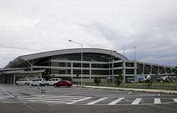
Iloilo International Airport (Iloilo Airport) is the airport serving the general area of Iloilo City, the capital city of the province of Iloilo and the regional center of the Western Visayas region in the Philippines. It opened its doors to commercial traffic on June 14, 2007 after a decade of planning and construction, replacing Mandurriao Airport in Iloilo City proper which had been in service for over seventy years. As a result, the new airport inherited its IATA and ICAO airport codes, as well as its position as the fourth-busiest airport in the Philippines, from its predecessor. In addition to being the first airport in both Western Visayas and the island of Panay to be built to international standards, it is considered one of four international airports in the Visayas with international flights to Hong Kong and Singapore.
The new Iloilo International Airport is located in Cabatuan;[3] specifically in Barangay Tabucan, Barangay Gaub, Barangay Duyan-Duyan and Barangay Manguna, all in Cabatuan. The airport can be reached either from the Cabatuan access roads (Barangay Tabucan and Barangay Tiring, Cabatuan) or from the Pavia-Santa Barbara-Cabatuan (Barangay Duyan-Duyan, Cabatuan) access road.[3] The airport complex consists of a single runway, various administrative and maintenance buildings, waste sorting and water treatment facilities, a power generating station, a cargo terminal and a main passenger terminal. Its location on the Tomas Confesor Highway, a major highway transversing the island, makes the airport accessible from all parts of Iloilo and Panay by road, while its proximity to the currently defunct Panay Railways network could potentially link the airport to the rest of Panay by rail.
Seaport
The Port of Iloilo is the port serving the general area of Iloilo and the rest of Panay Island and Guimaras Island.
There are 5 seaports in Metro Iloilo, these are the Iloilo Ferry Port and Terminal Complex, Iloilo River Port and Terminal Complex, Iloilo Domestic Port and Terminal Complex, Dumangas Ro - Ro Port and Terminal Complex and The Iloilo Commercial Port Complex which is located on 20.8 hectares of reclaimed land. It has facilities that include 11,400 sq. meters of open space for operations, supplemented by a backup area of 97,000 sq. meters, a crane, rails of 348 lineal meters, roll-on/roll-off support, a freight station, and a 720 sq. meter passenger shed. The port complex is ideal for ships plying international routes having a berth length of 400 meters, a width of 26.26 meters and a berthing depth of 10.50 meters.
There are a number of shipping companies that use the Port of Iloilo, among them, the Aboitiz Shipping Company, Amigo Shipping Company, New Panay Shipping Company, Negros Navigation Company, Sulpicio Lines, William Lines, and Trans-Asia Shipping Lines. Fast ferries serve Iloilo-Bacolod routes eight times daily. Negros Navigation and Superferry dock to the city where it serves routes going to Manila, Bacolod, Cebu, Zamboanga and Cagayan de Oro City.
Fishing Port
The only fishing port complex in the Visayas, the Iloilo Fish Port Complex is located at the mouth of the Batiano River on a reclaimed 20.5 hectare land.
Transport Terminal
Iloilo City boast of 5 integrated transport terminals, these are the Northern Iloilo Integrated Jeepney and Bus Terminal in Tagbac, Jaro. The Central Line Jeepney and Bus Terminal in Ungka, Jaro. The Upland Jeepney and Bus Terminal in Mandurriao. The Souther Coast Jeepney and Bus Terminal in Mohon, Arevalo and the North Coastal Jeepney and Bus Terminal in Ingore, Lapaz.
References
- 1 2 Census of Population (2015). Highlights of the Philippine Population 2015 Census of Population. PSA. Retrieved 20 June 2016.
- ↑ "Member Municipalities of Metro Iloilo–Guimaras". MIGEDC: Metro-Iloilo–Guimaras Economic Development Council. Retrieved 2009-09-07.
- 1 2 "Iloilo International Airport". IloiloAirport.com.
External links
| Current metro areas | |
|---|---|
| Proposed existing metro areas | |