Makato, Aklan
| Makato | |
|---|---|
| Municipality | |
| Municipality of Makato | |
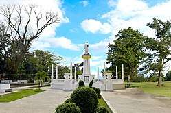 Rizal Monument at the Public Plaza | |
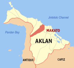 Map of Aklan with Makato highlighted | |
.svg.png) Makato Location within the Philippines | |
| Coordinates: 11°42′N 122°17′E / 11.7°N 122.28°ECoordinates: 11°42′N 122°17′E / 11.7°N 122.28°E | |
| Country |
|
| Region | Western Visayas (Region VI) |
| Province | Aklan |
| Barangays | 18 (see Barangays) |
| Government [1] | |
| • Type | Sangguniang Bayan |
| • Mayor | Abencio Torres |
| • Electorate | 17,999 voters (2016) |
| Area [2] | |
| • Total | 64.60 km2 (24.94 sq mi) |
| Population (2015 census)[3] | |
| • Total | 27,262 |
| • Density | 420/km2 (1,100/sq mi) |
| Time zone | UTC+8 (PST) |
| ZIP code | 5611 |
| PSGC | 060411000 |
| IDD : area code | +63 (0)36 |
| Climate type | Tropical climate |
| Income class | 4th municipal income class |
| Revenue (₱) | 72,442,221.30 (2016) |
| Native languages |
Aklan language Tagalog |
| Website |
www |
Makato, officially the Municipality of Makato, (Aklanon: Banwa it Makato; Hiligaynon: Banwa sang Makato; Filipino: Bayan ng Makato), is a 4th class municipality in the province of Aklan, Philippines. According to the 2015 census, it has a population of 27,262 people.[3]
In 1948, the arrabal of Tangalan, comprising the barrios of Tondog, Jawili, Dumatad, Afga, Baybay, Dapdap, Pudyot, Tagas, Tamalagon, Panayakan, Vivo, Lanipga, Napatag and Tamoko, was separated from Makato to form the municipality of Tangalan.[4]
Geography
Makato is located at 11°42′N 122°17′E / 11.7°N 122.28°E. It is 8 kilometres (5.0 mi) from Kalibo, the provincial capital.
According to the Philippine Statistics Authority, the municipality has a land area of 64.60 square kilometres (24.94 sq mi) [2] constituting 3.55% of the 1,821.42-square-kilometre- (703.25 sq mi) total area of Aklan.
Barangays
Makato is politically subdivided into 18 barangays.[5]
| PSGC | Barangay | Population | ±% p.a. | |||
|---|---|---|---|---|---|---|
| 2015[3] | 2010[6] | |||||
| 060411001 | Agbalogo | 4.1% | 1,127 | 990 | 2.50% | |
| 060411002 | Aglucay | 2.0% | 557 | 521 | 1.28% | |
| 060411003 | Alibagon | 2.4% | 641 | 543 | 3.21% | |
| 060411004 | Bagong Barrio | 1.8% | 487 | 429 | 2.44% | |
| 060411005 | Baybay | 7.6% | 2,077 | 1,916 | 1.55% | |
| 060411006 | Cabatanga | 4.6% | 1,246 | 1,144 | 1.64% | |
| 060411007 | Cajilo | 5.3% | 1,446 | 1,294 | 2.14% | |
| 060411008 | Calangcang | 6.3% | 1,715 | 1,701 | 0.16% | |
| 060411009 | Calimbajan | 7.6% | 2,068 | 1,855 | 2.09% | |
| 060411010 | Castillo | 3.5% | 956 | 791 | 3.67% | |
| 060411011 | Cayangwan | 7.8% | 2,125 | 2,058 | 0.61% | |
| 060411012 | Dumga | 8.0% | 2,170 | 2,107 | 0.56% | |
| 060411013 | Libang | 5.1% | 1,401 | 1,561 | −2.04% | |
| 060411014 | Mantiguib | 7.0% | 1,921 | 1,778 | 1.48% | |
| 060411015 | Poblacion | 12.1% | 3,288 | 3,172 | 0.69% | |
| 060411016 | Tibiawan | 3.2% | 869 | 785 | 1.95% | |
| 060411017 | Tina | 4.5% | 1,223 | 1,094 | 2.15% | |
| 060411018 | Tugas | 7.1% | 1,945 | 1,722 | 2.35% | |
| Total | 27,262 | 25,461 | 1.31% | |||
Demographics
| Population census of Makato | ||
|---|---|---|
| Year | Pop. | ±% p.a. |
| 1903 | 5,289 | — |
| 1918 | 11,661 | +5.41% |
| 1939 | 15,526 | +1.37% |
| 1948 | 9,939 | −4.84% |
| 1960 | 11,951 | +1.55% |
| 1970 | 13,287 | +1.06% |
| 1975 | 14,972 | +2.42% |
| 1980 | 16,732 | +2.25% |
| 1990 | 19,230 | +1.40% |
| 1995 | 21,955 | +2.51% |
| 2000 | 22,777 | +0.79% |
| 2007 | 25,043 | +1.32% |
| 2010 | 25,461 | +0.60% |
| 2015 | 27,262 | +1.31% |
| Source: Philippine Statistics Authority[3][6][7][8] | ||
In the 2015 census, Makato had a population of 27,262.[3] The population density was 420 inhabitants per square kilometre (1,100/sq mi).
Infrastructure
The Aklan Sports Complex (Opened in 2010) was located here at Makato, where the 2010 Western Visayas Regional Athletic Association (WVRAA) Meet takes place.[9]
References
- ↑ "Municipality". Quezon City, Philippines: Department of the Interior and Local Government. Retrieved 31 May 2013.
- 1 2 "Province: Aklan". PSGC Interactive. Quezon City, Philippines: Philippine Statistics Authority. Retrieved 12 November 2016.
- 1 2 3 4 5 Census of Population (2015). "Region VI (Western Visayas)". Total Population by Province, City, Municipality and Barangay. PSA. Retrieved 20 June 2016.
- ↑ "Republic Act No. 285 - An Act Creating the Municipality of Tangalan in the Province of Capiz". Chan Robles Virtual Law Library. 16 June 1948. Archived from the original on 26 September 2013. Retrieved 21 October 2016.
- ↑ "Municipal: Makato, Aklan". PSGC Interactive. Quezon City, Philippines: Philippine Statistics Authority. Retrieved 8 January 2016.
- 1 2 Census of Population and Housing (2010). "Region VI (Western Visayas)". Total Population by Province, City, Municipality and Barangay. NSO. Retrieved 29 June 2016.
- ↑ Censuses of Population (1903–2007). "Region VI (Western Visayas)". Table 1. Population Enumerated in Various Censuses by Province/Highly Urbanized City: 1903 to 2007. NSO.
- ↑ "Province of Aklan". Municipality Population Data. Local Water Utilities Administration Research Division. Retrieved 17 December 2016.
- ↑ "100315-R6-WVRAA4". Philippine Information Agency. July 9, 2018.
Places adjacent to Makato, Aklan | |
|---|---|
Kalibo (capital) | |
| Municipalities | |