Maayon
| Maayon | |
|---|---|
| Municipality | |
| Municipality of Ma-ayon | |
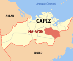 Map of Capiz with Maayon highlighted | |
.svg.png) Maayon Location within the Philippines | |
| Coordinates: 11°23′N 122°47′E / 11.38°N 122.78°ECoordinates: 11°23′N 122°47′E / 11.38°N 122.78°E | |
| Country |
|
| Region | Western Visayas (Region VI) |
| Province | Capiz |
| District | 1st district of Capiz |
| Barangays | 32 (see Barangays) |
| Government [1] | |
| • Type | Sangguniang Bayan |
| • Mayor | Wilfredo E. Borres Sr. |
| • Electorate | 22,964 voters (2016) |
| Area [2] | |
| • Total | 142.32 km2 (54.95 sq mi) |
| Population (2015 census)[3] | |
| • Total | 38,416 |
| • Density | 270/km2 (700/sq mi) |
| Time zone | UTC+8 (PST) |
| ZIP code | 5809 |
| PSGC | 061907000 |
| IDD : area code | +63 (0)36 |
| Climate type | Tropical climate |
| Income class | 3rd municipal income class |
| Revenue (₱) | 95,760,674.33 (2016) |
| Native languages |
Capiznon Hiligaynon Tagalog |
| Website |
www |
Maayon, officially the Municipality of Ma-ayon, is a 3rd class municipality in the province of Capiz, Philippines. According to the 2015 census, it has a population of 38,416 people.[3]
Sometimes spelled Ma-ayon, it is 32 kilometres (20 mi) from Roxas City.
Barangays
Maayon is politically subdivided into 32 barangays. [2]
- Aglimocon
- Alasaging
- Alayunan
- Balighot
- Batabat
- Bongbongan
- Cabungahan
- Canapian
- Carataya
- Duluan
- East Villaflores
- Fernandez
- Guinbi-alan
- Indayagan
- Jebaca
- Maalan
- Manayupit
- New Guia
- Quevedo (Ngalan)
- Old Guia
- Palaguian
- Parallan
- Piña
- Poblacion Ilawod
- Poblacion Ilaya
- Poblacion Tabuc
- Quinabonglan
- Quinat-uyan
- Salgan
- Tapulang
- Tuburan
- West Villaflores
Demographics
| Population census of Maayon | ||
|---|---|---|
| Year | Pop. | ±% p.a. |
| 1903 | 4,007 | — |
| 1960 | 16,386 | +2.50% |
| 1970 | 20,229 | +2.13% |
| 1975 | 23,075 | +2.68% |
| 1980 | 25,715 | +2.19% |
| 1990 | 29,808 | +1.49% |
| 1995 | 30,333 | +0.33% |
| 2000 | 32,700 | +1.62% |
| 2007 | 35,448 | +1.12% |
| 2010 | 36,430 | +1.00% |
| 2015 | 38,416 | +1.02% |
| Source: Philippine Statistics Authority[3][4][5][6] | ||
In the 2015 census, the population of Maayon was 38,416 people,[3] with a density of 270 inhabitants per square kilometre or 700 inhabitants per square mile.
References
- ↑ "Municipality". Quezon City, Philippines: Department of the Interior and Local Government. Retrieved 31 May 2013.
- 1 2 "Province: Capiz". PSGC Interactive. Quezon City, Philippines: Philippine Statistics Authority. Retrieved 12 November 2016.
- 1 2 3 4 Census of Population (2015). "Region VI (Western Visayas)". Total Population by Province, City, Municipality and Barangay. PSA. Retrieved 20 June 2016.
- ↑ Census of Population and Housing (2010). "Region VI (Western Visayas)". Total Population by Province, City, Municipality and Barangay. NSO. Retrieved 29 June 2016.
- ↑ Censuses of Population (1903–2007). "Region VI (Western Visayas)". Table 1. Population Enumerated in Various Censuses by Province/Highly Urbanized City: 1903 to 2007. NSO.
- ↑ "Province of Capiz". Municipality Population Data. Local Water Utilities Administration Research Division. Retrieved 17 December 2016.
External links
Places adjacent to Maayon | ||||||||||
|---|---|---|---|---|---|---|---|---|---|---|
| ||||||||||
Roxas (capital) | |
| Municipalities | |
| Component city | |
This article is issued from
Wikipedia.
The text is licensed under Creative Commons - Attribution - Sharealike.
Additional terms may apply for the media files.