Banga, Aklan
| Banga | ||
|---|---|---|
| Municipality | ||
| Municipality of Banga | ||
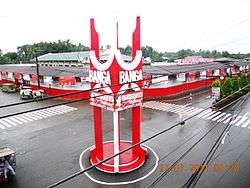 Downtown, with the rotunda and public market | ||
| ||
|
Motto(s): "Magbueoligan Kita" ("We Work Together") | ||
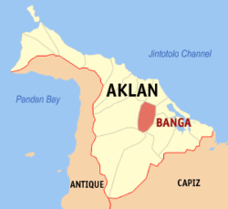 Map of Aklan with Banga highlighted | ||
.svg.png) Banga Location within the Philippines | ||
| Coordinates: 11°38′N 122°20′E / 11.63°N 122.33°ECoordinates: 11°38′N 122°20′E / 11.63°N 122.33°E | ||
| Country |
| |
| Region | Western Visayas (Region VI) | |
| Province | Aklan | |
| District | Lone district | |
| Founded | 1 January 1912 | |
| Barangays | 30 (see Barangays) | |
| Government [1] | ||
| • Type | Sangguniang Bayan | |
| • Mayor | Erlinda M. Maming | |
| • Electorate | 25,513 voters (2016) | |
| Area [2] | ||
| • Total | 84.53 km2 (32.64 sq mi) | |
| Population (2015 census)[3] | ||
| • Total | 39,505 | |
| • Density | 470/km2 (1,200/sq mi) | |
| Demonym(s) | Banganhon | |
| Time zone | UTC+8 (PST) | |
| ZIP code | 5601 | |
| PSGC | 060403000 | |
| IDD : area code | +63 (0)36 | |
| Climate type | Tropical climate | |
| Income class | 3rd municipal income class | |
| Revenue (₱) | 95,815,966.13 (2016) | |
| Native languages |
Aklan language Capiznon Tagalog | |
| Website |
elgu | |

Banga, officially the Municipality of Banga, (Aklanon: Banwa it Banga; Hiligaynon: Banwa sang Banga; Filipino: Bayan ng Banga), is a 3rd class municipality in the province of Aklan, Philippines. According to the 2015 census, it has a population of 39,505 people.[3]
Banga is the site of the Aklan State University.
Geography
Banga is located at 11°38′N 122°20′E / 11.63°N 122.33°E. It is 9 kilometres (5.6 mi) from Kalibo, the provincial capital.
According to the Philippine Statistics Authority, the municipality has a land area of 84.53 square kilometres (32.64 sq mi) [2] constituting 4.64% of the 1,821.42-square-kilometre- (703.25 sq mi) total area of Aklan.
Barangays
Banga is politically subdivided into 30 barangays.[4]
| PSGC | Barangay | Population | ±% p.a. | |||
|---|---|---|---|---|---|---|
| 2015[3] | 2010[5] | |||||
| 060403001 | Agbanawan | 3.9% | 1,524 | 1,458 | 0.85% | |
| 060403002 | Bacan | 4.3% | 1,703 | 1,637 | 0.76% | |
| 060403003 | Badiangan | 4.4% | 1,747 | 1,644 | 1.16% | |
| 060403004 | Cerrudo | 3.8% | 1,485 | 1,237 | 3.54% | |
| 060403005 | Cupang | 1.9% | 740 | 736 | 0.10% | |
| 060403006 | Daguitan | 1.2% | 459 | 477 | −0.73% | |
| 060403007 | Daja Norte | 3.4% | 1,340 | 1,563 | −2.89% | |
| 060403008 | Daja Sur | 1.3% | 512 | 602 | −3.04% | |
| 060403009 | Dingle | 1.8% | 698 | 723 | −0.67% | |
| 060403010 | Jumarap | 4.6% | 1,835 | 1,744 | 0.97% | |
| 060403011 | Lapnag | 1.6% | 627 | 594 | 1.03% | |
| 060403012 | Libas | 4.3% | 1,717 | 1,662 | 0.62% | |
| 060403013 | Linabuan Sur | 9.5% | 3,756 | 3,455 | 1.60% | |
| 060403014 | Mambog | 4.6% | 1,803 | 1,596 | 2.35% | |
| 060403015 | Mangan | 3.9% | 1,542 | 1,632 | −1.07% | |
| 060403016 | Muguing | 1.9% | 764 | 695 | 1.82% | |
| 060403017 | Pagsanghan | 4.9% | 1,917 | 1,735 | 1.92% | |
| 060403018 | Palale | 1.7% | 678 | 599 | 2.39% | |
| 060403019 | Poblacion | 5.1% | 1,997 | 2,469 | −3.96% | |
| 060403020 | Polo | 2.4% | 955 | 1,240 | −4.85% | |
| 060403021 | Polocate | 4.3% | 1,707 | 1,638 | 0.79% | |
| 060403022 | San Isidro | 0.8% | 320 | 305 | 0.92% | |
| 060403023 | Sibalew | 2.5% | 989 | 940 | 0.97% | |
| 060403024 | Sigcay | 2.6% | 1,012 | 974 | 0.73% | |
| 060403025 | Taba-ao | 2.9% | 1,164 | 1,196 | −0.52% | |
| 060403026 | Tabayon | 4.5% | 1,777 | 1,454 | 3.89% | |
| 060403027 | Tinapuay | 1.2% | 457 | 381 | 3.52% | |
| 060403028 | Torralba | 4.8% | 1,890 | 1,550 | 3.85% | |
| 060403029 | Ugsod | 4.0% | 1,566 | 1,426 | 1.80% | |
| 060403030 | Venturanza | 2.1% | 824 | 701 | 3.13% | |
| Total | 39,505 | 38,063 | 0.71% | |||
Demographics
| Population census of Banga | ||
|---|---|---|
| Year | Pop. | ±% p.a. |
| 1903 | 9,830 | — |
| 1918 | 11,432 | +1.01% |
| 1939 | 14,693 | +1.20% |
| 1948 | 17,977 | +2.27% |
| 1960 | 18,582 | +0.28% |
| 1970 | 21,560 | +1.50% |
| 1975 | 22,462 | +0.83% |
| 1980 | 25,034 | +2.19% |
| 1990 | 28,651 | +1.36% |
| 1995 | 30,071 | +0.91% |
| 2000 | 32,128 | +1.43% |
| 2007 | 34,276 | +0.90% |
| 2010 | 38,063 | +3.89% |
| 2015 | 39,505 | +0.71% |
| Source: Philippine Statistics Authority[3] [5] [6] [7] | ||
In the 2015 census, Banga had a population of 39,505.[3] The population density was 470 inhabitants per square kilometre (1,200/sq mi).
Government
Former heads of government
The following headed the town from the American Period until the present under two different titles. On 18 March 1945, after the landing of the American Liberation Forces and Philippine Commonwealth troops in Panay, the Philippine Civil Affairs Unit appointed Dr. Boanerjes Venturanza as the first Municipal Mayor.[8]
Municipal presidents
|
Mayors
|
Attractions
At the religious sanctuary of Manduyog Hill, an annual pilgrimage is conducted on Good Friday. Devotees practise the 14 Stations of the Cross, pray the rosary, and light candles at each stop while climbing towards the peak where a 40m cross, sometimes lighted, is visible from due north to Kalibo and the nearby sea.
References
- ↑ "Municipality". Quezon City, Philippines: Department of the Interior and Local Government. Retrieved 31 May 2013.
- 1 2 "Province: Aklan". PSGC Interactive. Quezon City, Philippines: Philippine Statistics Authority. Retrieved 12 November 2016.
- 1 2 3 4 5 Census of Population (2015). "Region VI (Western Visayas)". Total Population by Province, City, Municipality and Barangay. PSA. Retrieved 20 June 2016.
- ↑ "Municipal: Banga, Aklan". PSGC Interactive. Quezon City, Philippines: Philippine Statistics Authority. Retrieved 8 January 2016.
- 1 2 Census of Population and Housing (2010). "Region VI (Western Visayas)". Total Population by Province, City, Municipality and Barangay. NSO. Retrieved 29 June 2016.
- ↑ Censuses of Population (1903–2007). "Region VI (Western Visayas)". Table 1. Population Enumerated in Various Censuses by Province/Highly Urbanized City: 1903 to 2007. NSO.
- ↑ "Province of Aklan". Municipality Population Data. Local Water Utilities Administration Research Division. Retrieved 17 December 2016.
- ↑ Recoter, Remelyn. "A Brief History of Banga". BANGA's 1000. Archived from the original on 20 October 2016. Retrieved 20 October 2016.
External links
| Wikimedia Commons has media related to Banga, Aklan. |
- A Brief History of Banga on BANGA's 1000
- Historical Events that Took Place During the Term of the Governadorcillos on Angelfire