San Joaquin, Iloilo
| San Joaquin | |
|---|---|
| Municipality | |
| Municipality of San Joaquin | |
 San Joaquin Church | |
 Map of Iloilo with San Joaquin highlighted | |
.svg.png) San Joaquin Location within the Philippines | |
| Coordinates: 10°36′N 122°05′E / 10.6°N 122.08°ECoordinates: 10°36′N 122°05′E / 10.6°N 122.08°E | |
| Country |
|
| Region | Western Visayas (Region VI) |
| Province | Iloilo |
| District | 1st district of Iloilo |
| Barangays | 85 (see Barangays) |
| Government [1] | |
| • Type | Sangguniang Bayan |
| • Mayor | Ninfa S. Garin |
| • Electorate | 29,381 voters (2016) |
| Area [2] | |
| • Total | 234.84 km2 (90.67 sq mi) |
| Population (2015 census)[3] | |
| • Total | 51,892 |
| • Density | 220/km2 (570/sq mi) |
| Time zone | UTC+8 (PST) |
| ZIP code | 5024 |
| PSGC | 063040000 |
| IDD : area code | +63 (0)33 |
| Climate type | Tropical climate |
| Income class | 2nd municipal income class |
| Revenue (₱) | 143,220,253.74 (2016) |
| Native languages |
Kinaray-a language Hiligaynon Ati Tagalog |
| Website |
www |
San Joaquin, officially the Municipality of San Joaquin, (Kinaray-a: Banwa kang San Joaquin; Hiligaynon: Banwa sang San Joaquin; Filipino: Bayan ng San Joaquin), is a 2nd class municipality in the province of Iloilo, Philippines. According to the 2015 census, it has a population of 51,892 people.[3]
Geography
San Joaquin is located in the southern tip of Iloilo Province. One of the rivers that traverse the town is the Siwaragan River with Barangay Siwaragan and Bucaya situated in its mouth. It is the southernmost municipality in the province and is 53 kilometres (33 mi)[4] from the provincial capital, Iloilo City, and is 44 kilometres (27 mi) from San Jose de Buenavista, the capital of Antique.
Barangays
San Joaquin is subdivided into 85 barangays.
- Amboyu-an
- Andres Bonifacio
- Antalon
- Bad-as
- Bagumbayan
- Balabago
- Baybay
- Bayunan, also known as Panday Ora
- Bolbogan
- Bulho
- Bucaya
- Cadluman
- Cadoldolan
- Camia
- Camaba-an
- Cata-an
- Crossing Dapuyan
- Cubay
- Cumarascas
- Dacdacanan
- Danawan
- Doldol
- Dongoc
- Escalantera, also known as Dawis
- Ginot-an
- Huna
- Igaratong
- Igbaje
- Igbangcal
- Igbinangon
- Igburi
- Igcabutong
- Igcadlum
- Igcaphang
- Igcaratong
- Igcondao
- Igcores
- Igdagmay
- Igdomingding
- Iglilico
- Igpayong
- Jawod
- Langca
- Languanan
- Lawigan
- Lomboy
- Lopez Vito, also known as San Pedro
- Mabini Norte
- Mabini Sur
- Manhara
- Maninila
- Masagud
- Matambog
- Mayunoc
- Montinola
- Nagquirisan
- Nadsadan
- Nagsipit
- New Gumawan
- Panatan
- Pitogo
- Purok 1 (Poblacion)
- Purok 2 (Poblacion)
- Purok 3 (Poblacion)
- Purok 4 (Poblacion)
- Purok 5 (Poblacion)
- Qui-anan
- Roma
- San Luis
- San Mateo Norte
- San Mateo Sur
- Santiago
- Sinogbuhan
- Siwaragan
- Lomboyan, also known as Santa Ana
- Santa Rita
- Talagutac
- Tapikan
- Taslan
- Tiglawa
- Tiolas
- To-og
- Torocadan
- Ulay
- Bonga
- Guibongan Bayunan
Demographics
| Population census of San Joaquin | ||
|---|---|---|
| Year | Pop. | ±% p.a. |
| 1903 | 14,333 | — |
| 1918 | 17,834 | +1.47% |
| 1939 | 23,779 | +1.38% |
| 1948 | 22,255 | −0.73% |
| 1960 | 24,655 | +0.86% |
| 1970 | 29,610 | +1.85% |
| 1975 | 32,352 | +1.79% |
| 1980 | 34,525 | +1.31% |
| 1990 | 39,958 | +1.47% |
| 1995 | 44,191 | +1.90% |
| 2000 | 47,826 | +1.71% |
| 2007 | 50,102 | +0.64% |
| 2010 | 51,645 | +1.11% |
| 2015 | 51,892 | +0.09% |
| Source: Philippine Statistics Authority[3][5][6][7] | ||
In the 2015 census, the population of San Joaquin, Iloilo, was 51,892 people,[3] with a density of 220 inhabitants per square kilometre or 570 inhabitants per square mile.
Kinaray-a is the main language of San Joaquin. Hiligaynon is spoken as a secondary language and is also understood by the residents.
Landmarks
San Joaquin Church
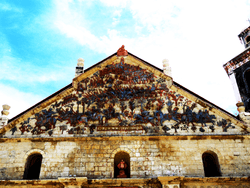
The main church in town, a Roman Catholic parish was constructed in 1859 and completed in 1869 by Spanish friar Tomas Santaren, of the Augustinian Order.[4] The church is unique among those in the Philippines for its large pediment featuring a military scene, the Spanish victory over the Moors in the Battle of Tetuan.[4][8] The National Museum of the Philippines listed the church as a National Cultural Treasure.[4][9]
San Joaquin Cemetery

The San Joaquin Cemetery is located along the main highway in San Joaquin Town. The construction of San Joaquin Cemetery was commenced by Fray Mariano Vamba, the last Augustinian parish priest of the town in 1892. A statue of Jesus with his arms outstretched stands on top of a baroque style gate, and on each side of Christ, two columns with angelic figures are poised as guards. In addition, sculpted heads of two cherubs and a skull representing death marks the entrance of the cemetery. Twenty stone steps after entering the gate and you will be greeted by the Baroque designed mortuary chapel standing on the center.[4]
Culture
The Bayluhay Festival, celebrated every third week of January, reflects the town’s unique mixture of races and cultures. Historical and religious themes, mostly anchored from the Barter of Panay, such as efforts with the preservation of rituals, are reflected through the dances presented in the festivity. Accentuated every annual municipal fiesta is the “Pasungay” or bull fight. During this affair, the best bulls from the different barangays are pitted against each other by weight category in a “bull derby”.[4]
Tourism
The Talisayan Beach Resort is a privately owned beach resort located in the Poblacion. The Cata-an Cove and Tobog Beach Resort in Barangay Cata-an, about 10 kilometers from the Poblacion, is a place perfect for scuba diving and weekend outings.
Garin Farm, a 15 hectare privately owned farm resort in Purok 2, Poblacion which showcases agriculture,leisure and pilgrimage theme. Practical and intelligent farming are imparted to the visitors through the agricultural techniques and innovative technologies applied in the demo farm. The resort leisure amenities include a swimming pool, a 5,000 sq.m man-made lagoon located on a hilltop, with fishes and lilies which offers fishing, boating and kayaking, and a 300 meters zip- line which goes over the lagoon and through the trees. On the top of the hill sits the 101 Feet Divine Mercy Cross, which can be accessed by a 456 step stairway. Along the stairway are life-size and lifelike statues depicting the Creation, Noah’s Ark, Ten Commandments, and the 9 Major Events of the Life of Jesus Christ.
Education
The town has 11 high schools. 2 of which are located in Poblacion.
- Don Felix Serra National High School (Mother School)(Poblacion)
- San Joaquin School of Fisheries (Poblacion)
- Tiolas National High School
- Lawigan National High School
- Valverde National High School
- Escalantera National High School
- Sinogbuhan National High School
- Bad-as National High School
- Ginot-an National High School
- Pitogo National High School
- Don Felix Serra National High School Lomboyan Extension
References
- ↑ "Municipality". Quezon City, Philippines: Department of the Interior and Local Government. Retrieved 31 May 2013.
- ↑ "Province: Iloilo". PSGC Interactive. Quezon City, Philippines: Philippine Statistics Authority. Retrieved 12 November 2016.
- 1 2 3 4 Census of Population (2015). "Region VI (Western Visayas)". Total Population by Province, City, Municipality and Barangay. PSA. Retrieved 20 June 2016.
- 1 2 3 4 5 6 "San Joaquin". Garin Farm. Retrieved 20 August 2012.
- ↑ Census of Population and Housing (2010). "Region VI (Western Visayas)". Total Population by Province, City, Municipality and Barangay. NSO. Retrieved 29 June 2016.
- ↑ Censuses of Population (1903–2007). "Region VI (Western Visayas)". Table 1. Population Enumerated in Various Censuses by Province/Highly Urbanized City: 1903 to 2007. NSO.
- ↑ "Province of Iloilo". Municipality Population Data. Local Water Utilities Administration Research Division. Retrieved 17 December 2016.
- ↑ "San Joaquin Church: A Cultural Gem of the Philippines". exploreiloilo.com. Retrieved 20 August 2012.
- ↑ aseavoy.tumblr.com http://aseavoy.weebly.com/blog/peaceful-tranquil-serene-going-through-history-with-reverence. Retrieved 20 September 2017. Missing or empty
|title=(help)
External links
| Wikimedia Commons has media related to San Joaquin, Iloilo. |
- San Joaquin on Philippine Standard Geographic Code
- Philippine Census Information
- San Joaquin on Local Governance Performance Management System

Places adjacent to San Joaquin, Iloilo | |
|---|---|
Iloilo (capital) | |
| Municipalities |
|
| Component city | |
| Highly urbanized city |
|