Bugasong
| Bugasong | |
|---|---|
| Municipality | |
| Municipality of Bugasong | |
 Bugasong seascape | |
 Map of Antique with Bugasong highlighted | |
.svg.png) Bugasong Location within the Philippines | |
| Coordinates: 11°03′N 122°04′E / 11.05°N 122.07°ECoordinates: 11°03′N 122°04′E / 11.05°N 122.07°E | |
| Country |
|
| Region | Western Visayas (Region VI) |
| Province | Antique |
| District | Lone district |
| Founded | 1591 |
| Barangays | 27 (see Barangays) |
| Government [1] | |
| • Type | Sangguniang Bayan |
| • Mayor | John Lloyd M. Pacete |
| • Electorate | 20,056 voters (2016) |
| Area [2] | |
| • Total | 203.71 km2 (78.65 sq mi) |
| Highest elevation (Mount Baloy) | 1,909 m (6,263 ft) |
| Population (2015 census)[3] | |
| • Total | 33,642 |
| • Density | 170/km2 (430/sq mi) |
| Demonym(s) | Bugasongnon |
| Time zone | UTC+8 (PST) |
| ZIP code | 5704 |
| PSGC | 060604000 |
| IDD : area code | +63 (0)36 |
| Climate type | Tropical climate |
| Income class | 3rd municipal income class |
| Revenue (₱) | 103,707,312.47 (2016) |
| Native languages |
Kinaray-a language Tagalog |
| Website |
elgu |
Bugasong, officially the Municipality of Bugasong, (Kinaray-a: Banwa kang Bugasong; Hiligaynon: Banwa sang Bugasong; Filipino: Bayan ng Bugasong), is a 3rd class municipality in the province of Antique, Philippines. According to the 2015 census, it has a population of 33,642 people.[3]
History
Long before the coming of the Spanish colonizers in the island of Panay, the town of Bugasong, (then a "balangay") forerunner of the Spanish influenced pronunciation "Barangay") was already a thriving settlement. It was settled by the early Malayans, who immigrated from Borneo sometime in the 13th century. Its aborigines-were the Atis or Negritos, the original settlers of the island of Panay. The early immigrants settled along the coast and established their own society, founded a government patterned after their government in Borneo. They established farming, fishing, raising of cattle and livestocks. Trade with neighboring islands was already a thriving business, notwithstanding that they have also trade relations among the Indo-Chinese traders. They traded their farm products; like rice, sugar, mongo, corn and livestocks while the Chinese traders brought along various kinds of clothings, silk, chinawares, jades and other merchandises.
The early barangay settlement was located between the present Paliwan river and Lumanggab brook which is still known as Jinalinan (meaning the place they have left) and transferred their settlement to another place, now the poblacion of Bugasong. The early settlers were Muslims, for their forebears were indoctrinated by the religion of Islam in the 13th century by Arab missionaries and traders who introduced it. Legend has it that the island of Panay- then called the confederation of Madyaas, whose ranking Chieftain was Datu Sumakwel- was purchased from the Ati Chief Marikudo for one gold sadok (salakot in Pilipino) by Datu Sumakwel and companions, and also one gold necklace for the vanity of datu Sumakwel's wife Maniwantiwan. The Atis then moved to the interior mountains of Panay. After the consummation of the sale, Chieftain Datu Sumakwel divided the island into three districts; namely: Irong-irong (Iloilo), Hantic (Antique) and Aklan which still carries that name. They settled along the coastal plains around the island and established their government. Laws were instituted, and famous among them was the Code of Kalantiaw. The early settlers were industrious. The laws promulgated by Datu Kalantiaw was the bible of the various barangays around the island and it became the forerunner of many later laws enacted by the people.
In the early days, people were peaceful, cooperative, prosperous and thought that the Spaniards were descendants of God. They were awed by the long cassocks of the friars and the soldier's uniforms. They began to trust them and many of them were indoctrinated into the Christian religion by the friars. Little by little, the friars succeeded in subjugating the people. The people were baptized and many of them have Hispanized their names and surnames, without even knowing what significance their name means.
The first Roman Catholic Church was founded in 1726 and constructed in 1727 with Friar Bias Urbano as its first parish priest. He was a missionary. The subjugation of the people were really attributable to those priests' for theirs was the confidence and trust of the people whereby the Spanish authorities were able to found and establish their government. The first Cabeza de Barangay (head of the town) was appointed upon the recommendation and, of course, the influence of the friars. In 1743, the first Cabeza de Barangay was "Sr. Don" Pedro Jauod. Thus was the town established. It will be noticed, that although most of the people's names and surnames were Hispanized, there still remains the original surnames up to the present time. Like the surnames Magbanua, Magwad, Panaguiton, Managuit, Magdayao, Bangcaya, Paghari-on, Magdato, Maguidgad, Bantolo, Magluyan, Balajediong, Lumugda, Siladan, Tano, Ala, Panlibuton, and many others.
In the beginning, the office of the Cabeza de Barangay was served by its Cabeza for a year. It began in 1743 up to 1863 or for a period of 120 years until the term Cabeza de Barangay was abolished and changed to Capitan Municipal. In 1863, Sr. Don Miguel Legaspi was appointed First Capitan Municipal. His tenure of office was for two years.
The name of the town "Bugason" was its official name from its founding by the Spaniards ,in 1727, and was in use up to the early American regime. It is believed that it was in 1904 during the incumbency of Don Simon Barcelo, the town's third municipal president, that the letter "g" was added. As early as 1910, the name Bugasong was already in use.
During the early days of the American regime, the term of office of the first municipal president was only for one year. From 1902 to 1912, they held office for two years until the passage of the Jones Law in 1916 where it provided for a three-year term of office. The first municipal president during the American regime ,Nas Don Mariano Kabayao. After him, Don Santiago Laureano was elected. The election was by the choice of the councilors and the principales (usually the illustrious heads of families in the poblacion). In 1916, the first municipal president elected was Fernando Soils (he died in 1930), who also was the first re-elected municipal president since 1901. In 1937, the last municipal president was Mr. Santiago Nietes. In January 1, 1938, under the charter of the Commonwealth of the Philippines, Jose S. Zamora was elected its first town mayor. In 1948, Candido Arangote was elected first municipal mayor under the Republic of the Philippines. He served in an appointive capacity after the second world war until the grant of the Philippine Independence in July 4, 1946. Thus was ended the ten year transition period of the Tyding-McDuffie Law, granting the Philippines its Commonwealth status.
In the early days of the American occupation in 1901, there were established schools, it began with grade one to grade four and it was only in the poblacion that the school was opened. Few took advantage of studying. Those who earlier took advantage of schooling became the nucleus of the first Filipino teachers, they were appointed to teach while learning in the process. Very few men and women took advantage of schooling which was benevolently offered by the Americans. One of the First teachers was Antonio Lagasca (who later became Justice of the Peace and Member of the Antique Provincial Board), Fernando Soils, Irene Kabayao, Guillermo Yson, Caridad Pacete and m~ny others. Sometime in 1910 many of those who belonged to the poorer families, sent their children to school with the children of the rich and illustrious families. The humane treatment of the American school administrators gave encouragements to the poorer classes to send their children and acquire education. The schooling to the higher grades- which was from grade VI to high school was usually offered in the provincial capital of Antique. Many also made the sacrifices by going to school at San Jose by hiking. Those who can afford, went horseback riding as was the vogue of the day. Vehicular transportation was still unknown in those days. Some may travel by boat. Provisions were sometimes carried by servants and for those cannot afford, they carry their own provisions themselves. These sacrifices paid dividends because many of those who graduated became teachers, professionals in their line of endeavor.
In 1918 during the presidency of Fernando Soils, his Vice-President, Geronimo Militante, who was acting at the time, succeeded in opening the grade six and seven. This gave opportunities to the poorer segment of the town that many of them took advantage of acquiring education. Complete elementary education was offered and many of those who finished became teachers. The old school site was then on the site of the present municipal building, north of Porvenir St., while other classes were conducted in the old municipal building, between Porvenir and Antonio Ma. Regidor Sts., fronting the municipal plaza, which now houses the Office of the Sangguniang Bayan. Some of the classes were in the houses of the prominent men, lik~ the residence of Mr. Sixto Pechayco in Pojo and Martin EscaSo in Ilaya.
The present school site west of the Roman Catholic Church and convent was claimed as church property by Rev. Jose Geraldez and his successor rev. Richard Knight. They opposed the claim of the municipal government headed by Fernando Soils. Due to the opposition of the church, Soils was forced to bring the case to the Court of First Instance to determine the ownership of that strip of land. Eventually, Soils with the help of witnesses, convinced the Court that the property belongs to the municipality. In 1925 during the presidency of the late Gregorio Vicente, and through the efforts of the late Governor Enrique Salvani, there was appropriated from the
National Government funds for the construction of the new Elementary School building of semi�permanent structure. Vicente did not live to see the school finished and it was during Guillermo Yson's term that the school was finished. At the time Gov. Enrique Salvani was very influential with Governor General Leonard Wood that he was able to succeed in getting more funds for Antique and Bugasong was one of its beneficiaries. The partial asphalting of the town proper and the construction of the local water works system were projects that were constructed during Yson's term of office. The Rizal monument was also constructed out of the civic-minded endeavor of the ladies of the time. Salvacion M. Soils, who became the President of the Woman's Club, was responsible for the collection of funds for the construction of the Rizal monument.
Sanitary conditions were introduced with the development of the school system. Toilets and suitable comfort rooms were provided in the school and most of the prominent families were sold to the idea of clean living. Potable water was available and epidemics which was then rampant in the 20s and 30s were stamped out. During those days, houses of even the illustrious families were by the "Pig System" (meaning they have comfort rooms whose escreta goes to the pigs roaming below it). It took quite a time for the sanitary authorities to influence those families to construct better toilets.
After the second world war in 1945, came the opening of rural high schools in most of big towns. BugaSong being one of these towns, opened its rural high school in what is now the present site of the Antique Vocational School. Although there were many misgivings, through the energetic efforts of some of its sons, Jose T. Bayog who became the first principal of the rural high school, the Central Antique High School was inaugurated in 1946. The PTA president, Jose B. Barcelo of the Bugasong Elementary School, was instrumental in securing bamboo materials and contributions of whatever kind just to make the school a reality. The school site was purchased from different owners and one of those who notably donated his land for the school site were the late Don Vicerite Laureano and Pastor Moscoso. Many contributed in money and voluntary donations that the school site was finally paid. It has a wide area of more that 8 hectares which was then Sitio Oroyan, east of Ylaya district. Many of the products of the old Central Antique High School are now prominent members of the community, it produced lawyers, doctors, engineers, teachers pharmacists, dentists and what have you. Some are now enjoying lucrative jobs in the National Government in Manila and other provinces.
The Central Antique High School was centrally located in the province of Antique. Before the year 1955, Congressman Tobias Fornier, a prominent member of Congress (he was Chairman, Committee on Appropriations, a powerful committee in Congress), proposed to the then Mayor Candido Arangote that the Central Antique High School shall he converted into the Antique School of Arts and Trades. Mayor Arangote and the members of the Municipal Council (with the exception of the writer who was also a member of the council) voted not to accept the offer of conversion. He reasoned that the name of Congressman Emigdio Nietes who contributed a lot in the construction of the Central Antique High School, will be lost if they accepted the office of Congressman Fornier. The offer for the construction of the Antique School of Arts and Trades was made to Sibalom, where it now stands- monument to the late Congressman Fornier.
In 1957 Congressman Tobias Fornier again offered the conversion of the Central Antique High School into a national vocational school. At first the Mayor and Council were reluctant, but after the first fiasco and sensing that the people have been tired of their antics, reluctantly accepted the offer. In the latter part of 1957 the school was converted and appropriations for the new school buildings were made.
Geography
Bugasong is located at 11°03′N 122°04′E / 11.05°N 122.07°E. It is 43 kilometres (27 mi) from the provincial capital, San Jose de Buenavista.
According to the Philippine Statistics Authority, the municipality has a land area of 203.71 square kilometres (78.65 sq mi) [2] constituting 7.46% of the 2,729.17-square-kilometre- (1,053.74 sq mi) total area of Antique.
Barangays
Bugasong is politically subdivided into 27 barangays.[4] Ilaures and Cubay Sur were sitios converted into barrios in 1957 and 1959, respectively.[5][6]
| PSGC | Barangay | Population | ±% p.a. | |||
|---|---|---|---|---|---|---|
| 2015[3] | 2010[7] | |||||
| 060604001 | Anilawan | 0.7% | 223 | 213 | 0.88% | |
| 060604002 | Arangote | 1.5% | 510 | 442 | 2.76% | |
| 060604003 | Bagtason | 5.3% | 1,786 | 1,779 | 0.07% | |
| 060604004 | Camangahan | 3.4% | 1,139 | 1,124 | 0.25% | |
| 060604018 | Centro Ilawod (Poblacion) | 6.0% | 2,020 | 1,934 | 0.83% | |
| 060604019 | Centro Ilaya (Poblacion) | 6.5% | 2,190 | 2,086 | 0.93% | |
| 060604020 | Centro Pojo (Poblacion) | 6.7% | 2,259 | 2,147 | 0.97% | |
| 060604005 | Cubay North | 5.4% | 1,813 | 1,635 | 1.99% | |
| 060604006 | Cubay South | 4.0% | 1,330 | 1,272 | 0.85% | |
| 060604009 | Guija | 3.4% | 1,140 | 1,078 | 1.07% | |
| 060604010 | Igbalangao | 5.3% | 1,773 | 1,754 | 0.21% | |
| 060604011 | Igsoro | 4.1% | 1,368 | 1,261 | 1.56% | |
| 060604012 | Ilaures | 4.1% | 1,391 | 1,361 | 0.42% | |
| 060604013 | Jinalinan | 3.1% | 1,053 | 955 | 1.88% | |
| 060604014 | Lacayon | 3.9% | 1,307 | 1,148 | 2.50% | |
| 060604015 | Maray | 1.4% | 468 | 398 | 3.13% | |
| 060604016 | Paliwan | 3.9% | 1,303 | 1,227 | 1.15% | |
| 060604017 | Pangalcagan | 6.1% | 2,053 | 1,805 | 2.48% | |
| 060604021 | Sabang East | 2.5% | 835 | 783 | 1.23% | |
| 060604022 | Sabang West | 2.4% | 801 | 689 | 2.91% | |
| 060604023 | Tagudtud North | 3.3% | 1,102 | 1,771 | −8.64% | |
| 060604024 | Tagudtud South | 3.1% | 1,044 | 944 | 1.94% | |
| 060604025 | Talisay | 2.9% | 982 | 953 | 0.57% | |
| 060604026 | Tica | 1.6% | 540 | 521 | 0.68% | |
| 060604027 | Tono-an | 2.2% | 745 | 671 | 2.01% | |
| 060604028 | Yapu | 1.6% | 551 | 527 | 0.85% | |
| 060604029 | Zaragoza | 5.7% | 1,916 | 1,786 | 1.35% | |
| Total | 33,642 | 32,264 | 0.80% | |||
Demographics
| Population census of Bugasong | ||
|---|---|---|
| Year | Pop. | ±% p.a. |
| 1903 | 11,101 | — |
| 1918 | 10,924 | −0.11% |
| 1939 | 14,863 | +1.48% |
| 1948 | 15,642 | +0.57% |
| 1960 | 16,635 | +0.51% |
| 1970 | 17,697 | +0.62% |
| 1975 | 17,988 | +0.33% |
| 1980 | 21,619 | +3.74% |
| 1990 | 24,537 | +1.27% |
| 1995 | 26,721 | +1.61% |
| 2000 | 28,294 | +1.23% |
| 2007 | 30,394 | +0.99% |
| 2010 | 32,264 | +2.20% |
| 2015 | 33,642 | +0.80% |
| Source: Philippine Statistics Authority[3] [7] [8] [9] | ||
In the 2015 census, Bugasong had a population of 33,642.[3] The population density was 170 inhabitants per square kilometre (440/sq mi).
Bugasongnons speak Kinaray-a as their main dialect while Hiligaynon is used as their secondary dialect.
Government
The current mayor of the town is John Lloyd Pacete with Bernard Pesayco as vice mayor. The town council is composed of ten members, eight are elected at large, while two are elected after the barangay elections. The current town council members are:
- Casimira de la Cruz
- Aida Uy Kimpang
- Gerardo Antoy
- Susan Escote
- Geraldine Pesayco
- Roberto Fruto
- Cyril Pesayco
- Renante Dava
- Krizel Joy Panaguiton (SK Municipal Federation President)
- Norma Sayon (Liga ng mga Barangay)
Tourism
The town celebrates its annual town fiesta every 18 January in honor of Santo Niño (the Holy Child). The local town festival, the Bugas Sa Lusong, is integrated with this celebration, with its opening salvo sometime between 10 and 12 January. The highlight of the celebration is the high mass on 18 January, usually celebrated by the diocesan bishop and visiting priests.
The patadyong, a colorful native fabric, is a well-known product made by the locals in barangay Bagtason.
The Estaca Hills historically served as the town's watch tower. Currently, it is a destination for hiking. From the top, one can see the entirety of Bugasong.
Schools
The town is the location of the only Dominican school in the province of Antique, Saint Joseph Academy, which was established on 1957. The school is run by the Dominican Sisters of the Most Holy Rosary of the Philippines. Notable alumni include former Deputy Ombudsman for the Visayas Atty. Pelagio Apostol and then National Artist Edsel Moscoso.
Other schools in the town include: Antique Vocational School, at the town proper; Northern Bugasong National School at barangay Cubay North; Southern Bugasong National School at barangay Igbalangao and Eastern Bugasong National High School (formerly Northern Bugasong National High School-Annex) at barangay Pangalcagan.
Gallery
 The summer heat in 2010 dried up the Cangaranan River
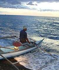 A local fisherman in Bugasong is set to hurdle the waves
 The historical Estaka hill
 The shores of Ilaures
 Saint Joseph Academy, the only Dominican school in Antique
References
- ↑ "Municipality". Quezon City, Philippines: Department of the Interior and Local Government. Retrieved 31 May 2013.
- 1 2 "Province: Antique". PSGC Interactive. Quezon City, Philippines: Philippine Statistics Authority. Retrieved 12 November 2016.
- 1 2 3 4 5 Census of Population (2015). "Region VI (Western Visayas)". Total Population by Province, City, Municipality and Barangay. PSA. Retrieved 20 June 2016.
- ↑ "Municipal: Bugasong". PSGC Interactive. Quezon City, Philippines: Philippine Statistics Authority. Retrieved 8 January 2016.
- ↑ "Republic Act No. 1743 - An Act Creating the Barrio of Ilaures in the Municipality of Bugasong, Province of Antique". Chan Robles Virtual Law Library. 21 June 1957. Archived from the original on 27 September 2013. Retrieved 30 October 2016.
- ↑ "Republic Act No. 2133; An Act Creating the Barrio of Cubay Sur in the Municipality of Bugasong, Province of Antique". The Corpus Juris. 7 April 1959. Archived from the original on 30 October 2016. Retrieved 30 October 2016.
- 1 2 Census of Population and Housing (2010). "Region VI (Western Visayas)". Total Population by Province, City, Municipality and Barangay. NSO. Retrieved 29 June 2016.
- ↑ Censuses of Population (1903–2007). "Region VI (Western Visayas)". Table 1. Population Enumerated in Various Censuses by Province/Highly Urbanized City: 1903 to 2007. NSO.
- ↑ "Province of Antique". Municipality Population Data. Local Water Utilities Administration Research Division. Retrieved 17 December 2016.
External links
| Wikimedia Commons has media related to Bugasong. |
Places adjacent to Bugasong | ||||||||||
|---|---|---|---|---|---|---|---|---|---|---|
| ||||||||||