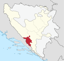
West Herzegovina Canton
| West Herzegovina Canton Županija Zapadnohercegovačka | |
|---|---|
 Coat of arms
| |
 | |
| Status | Canton of the Federation of Bosnia and Herzegovina |
| Capital and largest city | Široki Brijeg |
| Official languages | Croatian and Bosnian |
| Ethnic groups (2013[1]) |
98.76% Croats 0.76% Bosniaks 0.48% others |
| Demonym | West Herzegovinian |
| Government | Parliamentary system |
• Prime Minister | Zdenko Ćosić |
| Legislature | Assembly of West Herzegovina Canton |
| Canton of the Federation of Bosnia and Herzegovina | |
• Establishment | 12 June 1996 |
| Area | |
• Total | 1,362 km2 (526 sq mi) |
| Population | |
• 2013 census | 94,898 |
• Density | 71.87/km2 (186.1/sq mi) |
| GDP (nominal) | 2013 estimate |
• Total | BAM 487.211 million |
• Per capita | BAM 4976.97 |
| Currency | BAM |
| Time zone | UTC+1 (CET) |
| UTC+2 (CEST) | |
| Date format | dd-mm-yyyy |
| Driving side | right |
|
Website vladazzh | |
The West Herzegovina Canton (Bosnian: Zapadnohercegovački kanton, Croatian: Županija Zapadnohercegovačka) is one of the cantons of the Federation of Bosnia and Herzegovina. The West Herzegovina Canton is in the Herzegovina region in the southwest of Bosnia and Herzegovina. Its seat of government is in Široki Brijeg, while other municipalities within the Canton are Grude, Ljubuški and Posušje. It has 94,898 inhabitants, of whom more than 98% are ethnic Croats.
History
The majority of the present-day West Herzegovina Canton was part of Zachlumia, the medieval South Slavic principality. In the 15th century it become part of the Duchy of Saint Sava under Stjepan Vukčić Kosača, who proclaimed himself the herzog (duke), thus giving the name for the whole region - Herzegovina. The Ottomans conquered Herzegovina in 1483, when the territory of the West Herzegovina Canton become part of the Sanjak of Herzegovina. In 1833 the Sanjak of Herzegovina become more autonomous under Ali-paša Rizvanbegović, who became pasha of the Herzegovina Eyalet, however, after his death, Herzegovina once again become a sanjak. In 1878 the whole territory was occupied and later in 1908 annexed by the Austria-Hungary, who held it until 1918. During that time, the territory of the West Herzegovina Canton was part of the District of Mostar in the Condominium of Bosnia and Herzegovina.
After the collapse of the Austria-Hungary and after the creation of the Kingdom of Serbs, Croats and Slovenes, the territory of the West Herzegovina Canton remained part of the District of Mostar. However, with creation of banovinas in 1929, the territory become part of the Littoral Banovina, and in 1939 it was incorporated in the Banovina of Croatia, where it de iure remained until 1943.
During the World War II, the territory of the West Herzegovina Canton become part of the Independent State of Croatia, a Nazi-affiliated puppet state created in April 1941. Administratively, it was part of the County of Hum, having Mostar as its capital. The puppet state collapsed in May 1945.
The Yugoslav Partisans formed the People's Republic of Bosnia and Herzegovina (later renamed to Socialist Republic), as a federal unit of Yugoslavia, of which the territory of the West Herzegovina Canton become part as well. However, in the process of the collapse of the communist regime, ethnic Croats formed the Croatian Community of Herzeg-Bosnia, which encompassed all Croat-majority municipalities in Bosnia and Herzegovina, including those of the West Herzegovina Canton.
During the course of the Bosnian War, the Croatian Community of Herzeg-Bosnia was later proclaimed a republic in 1993. The following year, in 1994, it become part of the Croat-Bosniak Federation of Bosnia and Herzegovina, which led to the formation of ten cantons in June 1996, including the West Herzegovina Canton.
Geography
West Herzegovina Canton is located in the Herzegovina region of south west Bosnia and Herzegovina. It has Čvrsnica mountain to the north, Croatia to the west and south, and the Herzegovina-Neretva Canton to the east. The area of the Canton is 1,363 km²[2] (526 sq miles).
The canton has three rivers: Lištica, Trebižat and Ričina, and the Blidinje Lake. Its highest peak is Pločno on the Čvrsnica mountain, 2,228 metres.[2]
Politics and government
Assembly
The Assembly of the West Herzegovina Canton (Croatian: Skupština Županije Zapadnohercegovačke) is the legislature of the West Herzegovina Canton, serving as the unicameral representative body of the citizens of the West Herzegovina Canton. It has 23 representatives elected directly at the Bosnian general election. The representatives have a four-year term. The Assembly enacts the local Constitution, laws and other regulations and elects the Government.
Government
The Government of the West Herzegovina Canton (Croatian: Vlada Županije Zapadnohercegovačke) is led by the Prime Minister who has one deputy and it consists of seven ministries. The ministries have different seats, with each municipality having two ministries, while the capital Široki Brijeg serves as the seat of the Prime Minister.
| Position | Portfolio | Seat | Officeholder | Party | |
|---|---|---|---|---|---|
| Prime Minister | Široki Brijeg | Zdenko Ćosić | HDZ BiH | ||
| Deputy Prime Minister | Finance | Ljubuški | Toni Kraljević | HDZ BiH | |
| Minister | Internal Affairs | Ljubuški | Zdravko Boras | HDZ BiH | |
| Minister | Justice and Administration | Široki Brijeg | Anita Markić | HDZ BiH | |
| Minister | Economy | Posušje | Dario Sesar | HDZ BiH | |
| Minister | Urban Development, Construction and Environment | Posušje | Miroslav Ramljak | HDZ BiH | |
| Minister | Education, Science, Culture and Sports | Široki Brijeg | Ružica Mikulić | HDZ BiH | |
| Minister | Healthcare, Labor and Social Welfare | Grude | Stjepan Bogut | HDZ BiH | |
| Minister | Veterans | Grude | Mladen Begić | HDZ BiH | |
Flag and coat of arms
The flag and coat of arms of the canton were the same as the flag and coat of arms of the former Croatian Republic of Herzeg-Bosnia. Together with Canton 10, West Herzegovina also used the former Croatian Republic of Herzeg-Bosnia's flag and coat of arms. However, these symbols were deemed unconstitutional by the Federation Constitutional Court, because "it only represented one group".[3]
Defying the court's ruling, and contrary to Canton 10, the West Herzegovina canton continues using these symbols, and the coat of arms is used at official institutions.
Economy
According to the data of the Federal Institute for Development Programming, the West Herzegovina Canton had the nominal GDP of 487.211 million BAM, the 7th largest in the Federation of Bosnia and Herzegovina, before the Canton 10, the Bosnian Podrinje Canton Goražde and the Posavina Canton. It generated 2.90% of the total GDP of the Federation of Bosnia and Herzegovina. The West Herzegovina Canton has 5th largest GDP per capita, amounting to 5,973 BAM, while the average in the Federation of Bosnia and Herzegovina is 7,188 BAM.[4]
| GDP of the West Herzegovina Canton 2007–2013 (mil. KM) | ||||||||||||
| 2007 | 2008 | 2009 | 2010 | 2011 | 2012 | 2013 | ||||||
|---|---|---|---|---|---|---|---|---|---|---|---|---|
| 398.322 | 437.314 | 442.805 | 446.177 | 462.491 | 474.716 | 487.211 | ||||||
| Participation in total FBiH economy | ||||||||||||
| 2.90% | 2.90% | 2.92% | 2.90% | 2.90% | 2.90% | 2.90% | ||||||
| Unemployment in the West Herzegovina Canton 2007–2013 (mil. KM) | ||||||||||||
| 2007 | 2008 | 2009 | 2010 | 2011 | 2012 | 2013 | ||||||
|---|---|---|---|---|---|---|---|---|---|---|---|---|
| 43.5% | 39.9% | 39.0% | 36.1% | 36.4% | 37.2% | 39.3% | ||||||
| Average in the FBiH | ||||||||||||
| 47.0% | 44.0% | 45.4% | 45.4% | 45.7% | 46.8% | 47.4% | ||||||
This region, before the war, was one of the poorest regions in BiH. Today it is one of the richest.[5][6] Despite the canton's small size in area, its agricultural sector is important. In the canton, 30,000 ha (120 sq miles) is used for agriculture; 84,000 ha (320 sq miles) is forest. Around 6,000 ha of arable land is below 100 metres in altitude. The Canton has a strong potential for the production of vegetables, fruit and wine, as well as meat and milk processing plants.[6]
Infrastructure
The West Herzegovina Canton has a central location in Herzegovina, and as such has favorable traffic characteristics. The future route of the motorway of the E73 corridor, where there is also a connection with the A1 motorway from Dubrovnik to Zagreb, which means the entire West Herzegovina Canton in encircled by two EU corridors, the E73 and the E65. The crossroad of these corridors is in the hinterland of Ploče port, making the Canton of West Herzegovina the "portal of the South East Europe".[7]
Demographics
| Municipality | Nationality | Total | |||||||
|---|---|---|---|---|---|---|---|---|---|
Croats |
% |
Bosniaks |
% |
Serbs |
% |
Other |
% | ||
| Ljubuški | 26,127 | 92.19 | 1,592 | 5.62 | 65 | 0.23 | 556 | 1.96 | 28,340 |
| Široki Brijeg | 26,864 | 98.91 | 9 | 0.03 | 148 | 0.54 | 139 | 0.51 | 27,160 |
| Posušje | 16,963 | 99.00 | 6 | 0.04 | 9 | 0.05 | 156 | 0.91 | 17,134 |
| Grude | 16,210 | 99.10 | 4 | 0.02 | 9 | 0.06 | 135 | 0.35 | 16,358 |
| Canton | 86,164 | 96.82 | 1,611 | 1.81 | 231 | 0.26 | 986 | 1.11 | 88,992 |
2013 Census
| Municipality | Nationality | Total | |||||
|---|---|---|---|---|---|---|---|
Bosniaks |
% |
Croats |
% |
Serbs |
% | ||
| ZAPADNOHERCEGOVAČKA ŽUPANIJA | 702 | 0.73 | 93,783 | 98.82 | 55 | 0.05 | 94,898 |
Page text.[8]
Official holidays
According to local laws, the official holidays (non-working days) in the county are:
- January 1 – New Year
- January 6 – Epiphany
- May 1 – Labour Day
- May 30 – Pan-Croatian statehood day
- August 15 – Assumption of Mary
- November 1 – All Saints' Day
- November 2 – All Souls' Day
- November 18 – the foundation of Herzeg-Bosnia
- December 25 and 26 – Christmas Day and St Stephen's Day
See also
References
Notes
- ↑ Sarajevo, juni 2016. CENZUS OF POPULATION, HOUSEHOLDS AND DWELLINGS IN BOSNIA AND HERZEGOVINA, 2013 FINAL RESULTS (PDF). BHAS. Retrieved 30 June 2016.
- 1 2 "Općenito o Županiji" (in Croatian). Government of the West Herzegovina Canton. Retrieved 16 August 2012.
- ↑ "U-11/97". Archived from the original on 19 April 2008. Retrieved 2009-06-08.
- ↑ FZZPR 2014, p. 5.
- ↑ "Bakula: Nemamo izbora - smanjit ćemo plaće". Poskok.info. Retrieved 29 December 2016.
- 1 2 "Poljoprivreda". Government of the West Herzegovina Canton. Retrieved 28 August 2012.
- ↑ REDAH 2010, p. 30.
- ↑ Link text, additional text.
Books
- Group of authors (2010). Studija razvoja poslovnih zona u Zapadnohercegovačkoj županiji (in Croatian). Mostar: REDAH.