Herzegovina-Neretva Canton
| Herzegovina-Neretva Canton Hercegovačko-neretvanski kantonHercegovačko-neretvanska županija | |
|---|---|
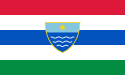 Flag
 Coat of arms
| |
 | |
| Status | Canton of the Federation of Bosnia and Herzegovina |
| Capital and largest city | Mostar |
| Official languages | Bosnian, Croatian, Serbian |
| Ethnic groups (2013[1]) | 53.29% Croats41.44% Bosniaks2.90% Serbs2.37% others |
| Demonym | Herzegovnian-Neretvanian |
| Government | Parliamentary system |
• Prime Minister | Nevenko Herceg |
| Legislature | Assembly of the Herzegovina-Neretva County |
| Canton of the Federation of Bosnia and Herzegovina | |
• Establishment | 12 June 1996 |
| Area | |
• Total | 4,401 km2 (1,699 sq mi) |
| Population | |
• 2013 census | 222,007 |
• Density | 53.69/km2 (139.1/sq mi) |
| GDP (nominal) | 2013 estimate |
• Total | BAM 1,184.630 |
• Per capita | BAM 5013.71 |
| Currency | BAM |
| Time zone | UTC+1 (CET) |
| UTC+2 (CEST) | |
| Date format | dd-mm-yyyy |
| Driving side | right |
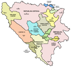
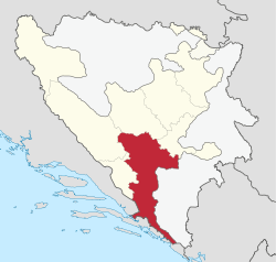
The Herzegovina-Neretva Canton (Croatian: Hercegovačko-neretvanska županija;[2] Bosnian: Hercegovačko-neretvanski kanton[3]) is one of 10 cantons of the Federation of Bosnia and Herzegovina in Bosnia and Herzegovina.
The canton mainly comprises the Neretva river valley area and parts of Herzegovina west of Mostar, its administrative center.
Municipalities
The canton is split into the municipalities of Čapljina, Čitluk, Jablanica, Konjic, Mostar, Neum, Prozor-Rama, Ravno and Stolac.
Geography and features
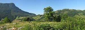
The canton is the only canton in Bosnia and Herzegovina with access to the sea via the municipality of Neum. Neum is a town of 2,000 citizens (1991 census) and the area around the city is rich with historical and archeological remains of the Illyrians, a people who lived in the Balkans for many thousands of years.
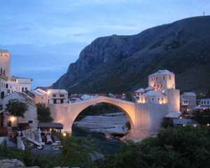
The largest city in the canton and the fifth largest city in the country is Mostar. Mostar is located on the banks of the Neretva river and is divided between Croats and Bosniaks. Mostar is known for its old bridge, Stari Most, which was constructed by the area's Ottoman rulers, who also brought Islam to the region. Bosnian Croat forces bombed and destroyed the bridge on November 8, 1993. Upon its destruction it had stood for 427 years and had become a symbol of a shared cultural heritage and "peaceful" co-existence. The bridge was reconstructed in the summer of 2004. The opening ceremony was attended by several foreign delegates including Stjepan Mesić, the President of Croatia.
Other notable cities in this canton are Čapljina, Konjic, Jablanica and Međugorje, the most significant Marian shrine in the region. Jablanica and Konjic are notable for battles which took place there during World War II and there is a large museum in Jablanica dedicated to these battles.
The Neretva river runs through the cities of Konjic, Jablanica, Mostar and Čapljina before it flows through Croatia and into the Adriatic Sea. There are large lakes in the canton such as the Jablanica lake located around the city Jablanica. The southern most municipality in the canton is the Neum municipality which borders the Adriatic sea and the eastern most municipality is the Ravno municipality along the border with Croatia.
Demographics
Of the ten cantons comprising the Federation of Bosnia Herzegovina, Herzegovina-Neretva Canton is one of two cantons, the other being the Central Bosnia Canton, nearly equally populated by Bosniaks and Croats. In such cantons there are special legislative procedures for the protection of the constituent ethnic groups.
Croats form a majority in the municipalities of Čapljina, Čitluk, Neum, Prozor-Rama, and Ravno. Bosniaks form an absolute majority in the municipalities of Jablanica and Konjic, and a relative majority in Stolac and Mostar according to the 1991 census.
2013 Census
| Municipality | Nationality | Total | |||||
|---|---|---|---|---|---|---|---|
Bosniaks |
% |
Croats |
% |
Serbs |
% | ||
| Čapljina | 4,541 | 17.36 | 20,538 | 78.51 | 714 | 2.72 | 26,157 |
| Čitluk | 29 | 0.15 | 17,900 | 98.67 | 18 | 0.09 | 18,140 |
| Jablanica | 9,045 | 89.45 | 726 | 7.18 | 63 | 0.62 | 10,111 |
| Konjic | 22,486 | 89.41 | 1,553 | 6.17 | 355 | 1.41 | 25,148 |
| Mostar | 46,752 | 44.19 | 51,216 | 48.40 | 4,421 | 4.17 | 105,797 |
| Neum | 63 | 01.35 | 4,543 | 97.63 | 21 | 0.45 | 4,653 |
| Prozor-Rama | 3,525 | 24.69 | 10,702 | 74.94 | 3 | 0.02 | 14,280 |
| Ravno | 20 | 0.62 | 2,633 | 81.79 | 558 | 17.33 | 3,219 |
| Stolac | 5,544 | 38.22 | 8,486 | 58.51 | 279 | 1.92 | 14,502 |
| Canton | 92,005 | 41.44 | 118,297 | 53.28 | 6,432 | 2.89 | 222,007 |
Page text.[4]
See also
References
- ↑ Sarajevo, juni 2016. CENZUS OF POPULATION, HOUSEHOLDS AND DWELLINGS IN BOSNIA AND HERZEGOVINA, 2013 FINAL RESULTS (PDF). BHAS. Retrieved 30 June 2016.
- ↑ The Constitution of the Herzegovina-Neretva Canton (Croatian)
- ↑ The Constitution of the Herzegovina-Neretva Canton (Bosnian)
- ↑ Link text, additional text.