Brčko
| Brčko Брчко | |
|---|---|
| Town and municipality | |
.jpg) Brčko | |
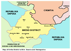
 Brčko Location within Bosnia and Herzegovina | |
| Coordinates: 44°52′N 18°49′E / 44.87°N 18.81°E | |
| Country |
|
| District | Brčko District |
| Government | |
| • Mayor | Siniša Milić (SNSD) |
| • President of the District Assembly | Esed Kadrić (SDA) |
| • International Supervisor (Suspended) | Bruce G. Berton |
| Area | |
| • Town and municipality | 402 km2 (155 sq mi) |
| Elevation | 92 m (302 ft) |
| Population (2013 census)[1] | |
| • Town and municipality | 83,516 |
| • Density | 210/km2 (540/sq mi) |
| • Urban | 43,007 |
| Postcode | 76100 |
| Area code(s) | +387 049 |
| Website | Official website |
Brčko (pronounced [br̩̂tʃkoː]) is a town, municipality and the administrative seat of Brčko District in northern Bosnia and Herzegovina. It lies on the banks of Sava river across from Croatia. As of 2013, it has a population of 83,516 inhabitants.
It is the only existent entirely self-governing free city in Europe.[2]
Name
Its name is very likely linked to the Breuci, an Illyrian tribe inhabiting the area in antiquity.
Geography
The city is located on the country's northern border, across the Sava River from Gunja in Croatia.
Brčko is the seat of the Brčko District, an independent unit of local self-government created on the territory of Bosnia and Herzegovina following an arbitration process. The local administration was formerly supervised by an international supervisory regime headed by Principal Deputy High Representative who is also ex officio the Brčko International Supervisor. This international supervision was frozen since 23 May 2012.[3]
History
Brčko was a geographic point of contention in 1996 when the U.S.-led Implementation Force (IFOR) built Camp McGovern on the outskirts of the city. Camp McGovern under the overwatch of 3-5 CAV 1/BDE/1AR Division (US) commanded by LTC Anthony Cucculo was constructed from a war torn farming cooperative structure in the Zone of Separation (ZOS) for the purpose of establishing peacekeeping operations. The mission was to separate the forming warring factions. The ZOS was one kilometer wide of no man's land, where special permission was required for Serbian or Bosnian forces to enter. Various checkpoints and observation points (OP's) were established to control the separation.
Although Brčko was a focal point for tension in the late 1990s, considerable progress in multi-ethnic integration in Brčko has since occurred including integration of secondary schooling. Reconstruction efforts and the Property Law Implementation Plan have improved the situation regarding property and return. Today, Brčko has returned to a strategic transshipment point along the Sava River. The population of Brčko has not returned to its pre-war ethnic mix of Bosniacs, Serbs, and Croats. Brčko sits at the east-west apex of Republika Srpska, the ethnic Serb portion of Bosnia & Herzegovina, and as such is critical to the RS for its economic future.
Brčko was the strategic component of Dayton Peace Accords which could not be negotiated. After several weeks of intensive negotiation, the issue of Brčko was to be decided by international arbitration. Brčko Arbitration ruled in May 1997 that Brčko would be a special district managed by an ambassadorial representative from the international community. The first Ambassador to Brčko was an American with support staff from the UK, Sweden, Denmark & France.
The first international organization to open office in Brčko at that time was the Organization for Security and Cooperation in Europe (OSCE) headed by Randolph Hampton.
Following PIC meeting on 23 May 2012, it was decided to suspend, not terminate, the mandate of Brčko International Supervisor. Brčko Arbitral Tribunal, together with the suspended Brčko Supervision, will still continue to exist.[3]
Demographics
| Historical population | ||
|---|---|---|
| Year | Pop. | ±% p.a. |
| 1948 | 49,969 | — |
| 1953 | 65,078 | +5.43% |
| 1971 | 74,771 | +0.77% |
| 1981 | 82,768 | +1.02% |
| 1991 | 87,627 | +0.57% |
| 2013 | 83,516 | −0.22% |
According to 2013 census the Brčko district had 83,516 inhabitants
Ethnic groups
The ethnic composition of Brčko:[4]
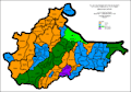 Ethnic structure of Brčko by settlements 1961
 Ethnic structure of Brčko by settlements 1971
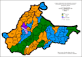 Ethnic structure of Brčko by settlements 1981
 Ethnic structure of Brčko by settlements 1991
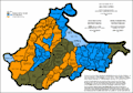 Ethnic structure of Brčko by settlements 2013
- 2013
| Village/Town | Nationality | Total | |||||
|---|---|---|---|---|---|---|---|
Bosniaks |
% |
Croats |
% |
Serbs |
% | ||
| Brčko Town | 17,489 | 44.40 | 1,457 | 03.65 | 19,420 | 49.30 | 39,893 |
Page text.[5]
Transport
Rail
A railway station is near the city centre on the line from Vinkovci to Tuzla. However, no passenger trains operate to Brčko. The closest operating railway station is in Gunja, Croatia; just on the other side of the border.
Sport
Brčko has three football clubs (FK Jedinstvo Brčko, FK Lokomotiva Brčko and the youngest club FK Ilićka 01). They all play in the Second League of Republika Srpska.
Features
Brčko has the largest port in Bosnia, on the Sava river. It is also home to an economics faculty and to a rather important theatre festival;
Gallery
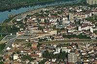 Panorama of Brčko
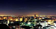 Brčko at night
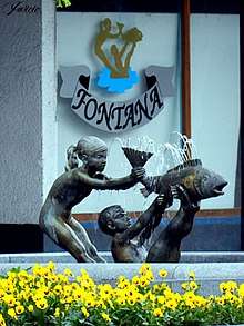 Fountain - the symbol of town
Twin towns — sister cities
Brčko is twinned with:
|
Famous residents
- Edo Maajka, rapper
- Lepa Brena, singer
- Edvin Kanka Ćudić, human rights defender
- Mladen Petrić, Croatian footballer
- Vesna Pisarović, singer
- Anil Dervisevic, Denver-errea volleyball club owner, Coach of woman's volleyball National Team of "Bosnia & Herzegovina"
- Dženana Šehanović, pianist
- Anton Maglica, Croatian footballer
- Jasmin Imamović, politician
- Nataša Vojnović, Serbian fashion model
- Mato Tadić, judge
- Brankica Mihajlović, Serbian volleyball player, silver medalist at the 2016 Summer Olympics
- Ines Janković, Serbian fashion designer
- Nikola Kovać, Professional Counter Strike Global Offensive player
See also
References
- ↑ "World Gazetteer: Bosnia and Herzegovina - largest cities (per geographical entity)". World-gazetteer.com. Archived from the original on 2006-03-16.
- ↑ Welcome to Brčko, Europe’s only free city and a law unto itself.
- 1 2 "Press Conference Following the Meeting of the Steering Board of the Peace implementation Council". Ohr.int. 2012-05-23. Retrieved 2013-11-23.
- ↑ "CENZUS OF POPULATION, HOUSEHOLDS AND DWELLINGS IN BOSNIA AND HERZEGOVINA, 2013 :: POPIS STANOVNIŠTVA, DOMAĆINSTAVA I STANOVA U BOSNI I HERCEGOVINI, 2013" (PDF). popis2013.ba. Agency for Statistics of Bosnia and Herzegovina :: Agencija za statistiku Bosne i Hercegovine. Retrieved 29 November 2016.
- ↑ Link text, additional text.
- ↑ "Koliko znamo o bratskim gradovima Brčkog? Prvi dio - Samsun". Portal Brčko. Retrieved June 26, 2015.
- ↑ "Koliko znamo o bratskim gradovima Brčkog? Drugi dio - St. Luis". Portal Brčko. Retrieved June 26, 2015.
- ↑ "Koliko znamo o bratskim gradovima Brčkog? Treći dio - Smederevska Palanka". Portal Brčko. Retrieved June 26, 2015.
| Wikimedia Commons has media related to Brčko. |
External links
- Brcko Government web site
- Ekonomski fakultet u Brčkom
- Brčanski Informativni portal
- Evropski univerzitet u Brčkom
- HIT Brčko
- Trka
Coordinates: 44°52′N 18°49′E / 44.87°N 18.81°E