Canton 10
| Canton 10 Herceg-Bosanska županija[1] | |
|---|---|
 | |
| Status | Canton of the Federation of Bosnia and Herzegovina |
| Capital |
Livno (executive) Tomislavgrad (legislative) |
| Largest city | Livno |
| Official languages | Serbian, Bosnian, Croatian |
| Ethnic groups (2013) |
76.79% Croats 12.96% Serbs 9.55% Bosniaks |
| Government | Parliamentary system |
• Prime Minister | Ivan Jozić |
| Legislature | Assembly of the Herzeg-Bosnia County |
| Canton of the Federation of Bosnia and Herzegovina | |
• Establishment | 12 June 1996 |
| Area | |
• Total | 4,934.1 km2 (1,905.1 sq mi) |
| Population | |
• 2013 census | 84,127 |
• Density | 17/km2 (44.0/sq mi) |
| GDP (nominal) | 2013 estimate |
• Total | BAM 420.009 million |
• Per capita | BAM 4629.37 |
| Currency | BAM |
| Time zone | UTC+1 (CET) |
| UTC+2 (CEST) | |
| Date format | dd-mm-yyy |
| Driving side | right |
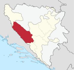
Canton 10[2], also known under disputed name Herzeg-Bosnian canton (Croatian: Hercegbosanska županija/Kanton 10; Bosnian: Kanton 10; Serbian Cyrillic: Кантон 10) is the largest of the cantons of the Federation of Bosnia and Herzegovina by size and eighth by population. It mainly covers an area of the historical and geographical region of Tropolje. The local government seat is in Livno, while the assembly is in Tomislavgrad.[3]
Name and symbols
In Croatian, the term županija (county) is used, while in Bosnian and Serbian the term is kanton/кантон. The canton is officially referred by the Federation of Bosnia and Herzegovina as Canton 10/County 10 (Kanton 10 or Županija 10).[4] The local government, however, refers to it as the Herzeg-Bosnia County (Hercegbosanska županija) and uses that name in the local constitution.[5][6] Other names used at the national level include North Herzegovina Canton/County (Sjevernohercegovački kanton, Sjevernohercegovačka županija) and Livno Canton (Livanjski kanton), after its capital.[7][8][9]
The flag and coat of arms of the canton under its constitution are the same as the flag and coat of arms of the former Croatian Republic of Herzeg-Bosnia.[10] West Herzegovina Canton also uses this flag and coat of arms. However, these symbols were deemed unconstitutional by the Federation's Constitutional Court, because "they only represented one group".[4] Defying the court's ruling, the local government continues to use these symbols, and the coat of arms is used at plates at the official institutions. Due to the name and symbols dispute, the local police have no official badges.[1]
 Disputed flag is still sometimes hoisted on all of local official institutions
 Disputed coat of arms as imprinted on old plates is still in use on most of local official institutions
Geography
The total area of the County is approximately 4,934 square kilometres (1,910 sq mi), a tenth of the surface of Bosnia-Herzegovina and c. 19% of the Federation.[11] The region is located between Dalmatia to the west, Una-Sana Canton to the north, Central Bosnia Canton to the east and West Herzegovina Canton and Herzegovina-Neretva Canton to the south and southeast.
Topography
Mountainous terrain of the region is a part of the Dinaric Alps, linked from a fold and thrust belt dating from the late Jurassic period, itself part of the Alpine orogeny, extending southeast from the southern Alps. The Dinarides form part of a chain of mountains that stretch across southern Europe and isolate Pannonian Basin from the Mediterranean Sea. The highest mountain of the Tropolje Dinarides is Mount Vran, located on the border of the municipalities of Tomislavgrad and Jablanica with the peak called Veliki Vran (Great Vran) at 2,074 metres (6,804 ft).
| Highest mountains of Tropolje | |||
|---|---|---|---|
| Mountain | Peak | Elevation | Coordinates |
| Vran | Veliki Vran | 2,074 m (6,804 ft) | 43°40′4.8″N 17°30′18″E / 43.668000°N 17.50500°E |
| Vran | Mali Vis | 2,014 m (6,608 ft) | 43°40′41.34″N 17°29′57.08″E / 43.6781500°N 17.4991889°E |
| Cincar | Cincar | 2,006 m (6,581 ft) | 43°54′08″N 17°03′46″E / 43.90222°N 17.06278°E |
| Vran | Crno Brdo | 1,966 m (6,450 ft) | 43°40′52.96″N 17°29′37.3″E / 43.6813778°N 17.493694°E |
| Vran | Mali Vran | 1,961 m (6,434 ft) | 43°39′8.8″N 17°17′27″E / 43.652444°N 17.29083°E |
| Vran | Bijela Glava | 1,949 m (6,394 ft) | 43°39′34″N 17°29′56″E / 43.65944°N 17.49889°E |
| Vitorog | Veliki Vitorog | 1,907 m (6,257 ft) | 44°7′12″N 17°2′45″E / 44.12000°N 17.04583°E |
| Golija | Veliki Vrh | 1,886 m (6,188 ft) | 43°59′12″N 16°47′21″E / 43.98667°N 16.78917°E |
| Vran | Priorac | 1,881 m (6,171 ft) | 43°39′37″N 17°28′27″E / 43.66028°N 17.47417°E |
| Šator | Veliki Šator | 1,872 m (6,142 ft) | 44°9′26″N 13°35′23″E / 44.15722°N 13.58972°E |
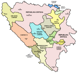
Political subdivisions
.png)
Canton 10 includes 6 municipalities: Drvar, Bosansko Grahovo, Glamoč, Kupres, Livno and Tomislavgrad.
| Coat of arms | Municipality | Population [12] | Area (km2)[12] |
|---|---|---|---|
| Bosansko Grahovo | 3,091 | 780.0 | |
| Drvar | 7,506 | 1030.0 | |
| Glamoč | 4,038 | 1033.6 | |
| Kupres | 5,573 | 569.8 | |
| Livno | 37,487 | 994.0 | |
| Tomislavgrad | 33,032 | 967.4 |
Governance
The canton is governed by the Government of Canton 10 (Croatian: Vlada Hercegbosanske županije; Bosnian: Vlada Kantona 10; Serbian Cyrillic: Влада Кантона 10). The current government is a coalition of 2 parties led by Croatian Democratic Union. President of the government is Branko Ivković.[13]
Cantonal Assembly

The Cantonal Assembly (Croatian: Županijska skupština, Bosnian and Serbian: Kantonalna skupština/Кантонална скупштина) is the parliament of the Canton 10. It consists of 25 representatives elected by proportional representation for four-year terms of office.
| Political party | Assembly members | |||||||||
|---|---|---|---|---|---|---|---|---|---|---|
| 2002 | 2006 | 2010 | 2014 | currently | ||||||
| Croatian Democratic Union (HDZ) | 13 | 5 | 9 | 9 | 9 / 25 | |||||
| Alliance of Independent Social Democrats (SNSD) | 3 | 5 | 3 | 3 | 3 / 25 | |||||
| Croatian Democratic Union 1990 (HDZ 1990) | - | 6 | 4 | 4 | 2 / 25 | |||||
| Croatian Independent List (HNL) | - | - | - | 2 | 2 / 25 | |||||
| People's Party For Work And Betterment (NSRzB) | 2 | 1 | 3 | 2 | 2 / 25 | |||||
| Party of Democratic Action (SDA) | 2 | 2 | 2 | 2 | 2 / 25 | |||||
| Croatian Party of Rights (HSP) | 1 | 4 | 3 | 1 | 1 / 25 | |||||
| HSS of Stjepan Radić | - | - | - | 1 | 1 / 25 | |||||
| Social Democratic Party (SDP BiH) | 1 | 1 | 1 | 1 | 1 / 25 | |||||
| independent | - | - | - | - | 2 / 25 | |||||
| Sources:[14][15][16] | ||||||||||
Demographics
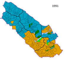

According to the 1991 census, 115.682 people inhabited the canton. Croats comprised 51.5%, Serbs comprised 35.7% and Bosnian Muslims comprised 10.4% of the population. Croats overwhelmingly lived in the southeastern part of the canton (Livno, Kupres, Tomislavgrad), while Serbs lived in northwestern (Grahovo, Glamoč, Drvar). There was a significant population migration during the war (1992–95). In 1992, Serb forces captured Kupres and the surrounding area, pushing away most of the non-Serb population. Croats returned at the end of 1994, after their forces have retaken Kupres. After Croat forces captured Grahovo, Glamoč and Drvar in the summer and fall of 1995, most of the Serb population fled. Refugee Croats from other parts of Bosnia and Herzegovina (fleeing Serb or Bosniak forces) settled in the abandoned area previously inhabited by the Serbs. After the war, under UN and peace implementation forces' pressure, Serb refugees returned to their homes.
In 2013, Canton's population included 76.79% Croats, 12.96% Serbs and 9.55% Bosniaks. Canton 10 had the largest share of ethnic Serbs in the Federation of Bosnia and Herzegovina. However, their number has steadily decreased since the war.
1991 Census
| Municipality | Nationality | Total | |||||||
|---|---|---|---|---|---|---|---|---|---|
Croats |
% |
Serbs |
% |
Bosniaks |
% |
Other |
% | ||
| Livno | 29,324 | 72.22 | 3,913 | 9.63 | 5,793 | 14.26 | 1,570 | 3.87 | 40,600 |
| Tomislavgrad | 25,976 | 86.56 | 576 | 1.91 | 3,148 | 10.49 | 309 | 1.02 | 30,009 |
| Glamoč | 184 | 1.46 | 9,951 | 79.02 | 2,257 | 17.92 | 201 | 1.58 | 12,593 |
| Kupres | 3,812 | 43.19 | 4,081 | 46.23 | 802 | 9.08 | 131 | 1.47 | 8,826 |
| Bosansko Grahovo | 226 | 2.71 | 7,888 | 94.91 | 12 | 0.14 | 185 | 2.22 | 8,311 |
| Drvar | 31 | 0.20 | 14,846 | 96.76 | 29 | 0.18 | 437 | 2.86 | 15,343 |
| Canton | 59,553 | 51.48 | 41,255 | 35.66 | 12,041 | 10.41 | 2,833 | 2.45 | 115,682 |
2013 Census
| Municipality | Nationality | Total | |||||||
|---|---|---|---|---|---|---|---|---|---|
Croats |
% |
Serbs |
% |
Bosniaks |
% |
Other |
% | ||
| Livno | 29,273 | 85.76 | 438 | 1.28 | 4,047 | 11.85 | 216 | 0.63 | 34,133 |
| Tomislavgrad | 29,006 | 91.81 | 22 | 0.06 | 2,467 | 7.80 | 30 | 0.09 | 31,592 |
| Glamoč | 906 | 23.47 | 1,679 | 43.49 | 1,251 | 32.40 | 13 | 0.33 | 3,860 |
| Kupres | 4,474 | 88.47 | 318 | 6.28 | 255 | 5.04 | 5 | 0.09 | 5,057 |
| Bosansko Grahovo | 393 | 16.04 | 2,028 | 82.80 | 6 | 0.24 | 10 | 0.40 | 2,449 |
| Drvar | 552 | 7.08 | 6,420 | 91.24 | 11 | 0.15 | 24 | 0.34 | 7,036 |
| Canton | 64,604 | 76.79 | 10,905 | 12.96 | 8,037 | 9.55 | 298 | 0.35 | 84,127 |
Economy
_Touristic_Map.png)
The canton has significant natural resources, with large reserves of coal and timber, as well as hydro & wind power. Due to economic reasons (insufficient county revenues compared to expenses) unification with West Herzegovina County has been proposed.[17][18]
See also
References
- 1 2 "Naslovna - Ministarstvo unutranjih poslova Kantona 10". mupk10livno.com (in Croatian and Bosnian). Ministarstvo unutranjih poslova K10. Retrieved 19 July 2018.
- ↑ "Ustav Hercegbosanske županije" (PDF) (in Croatian). Government of the Herzeg-Bosnia County. 23 December 1996. Retrieved 28 July 2012.
- ↑ www.skupstinahbz.com. "Skupština Hercegbosanske županije". www.skupstinahbz.com. Retrieved 6 April 2018.
- 1 2 "U-11/97". Archived from the original on 2008-04-19. Retrieved 2009-06-08.
- ↑ "hbzup.com". www.hbzup.com. Retrieved 6 April 2018.
- ↑ "Vlada Hercegbosanske županije". www.vladahbz.com. Retrieved 6 April 2018.
- ↑ "Utopio se pijan plivajući u Buškom jezeru". sarajevo-x.com. Retrieved 6 April 2018.
- ↑ "mediainfo.ba - Livanjski kanton: Do 2010. godine biće izgrađene prve vjetrenjače". mediainfo.ba. Retrieved 6 April 2018.
- ↑ "24sata.info - Livanjski kanton: Ministar zdravlja Darko Horvat lomio po kafani!". 24sata.info. Retrieved 6 April 2018.
- ↑ "Ustav - Vlada Hercegbosanske županije" (PDF). Vlada Hercegbosanske županije. 12 October 2005. p. 3.
- ↑ http://www.fzs.ba/Podaci/OSNOVNE%2520INFO%252010b.htm
- 1 2 (in Bosnian)(in Croatian) "PRELIMINARY RESULTS Of the 2013 Census of Population, Households and Dwellings in Bosnia and Herzegovina" (PDF). www.bhas.ba/. Agency for Statistics of Bosnia and Herzegovina. 5 November 2013. Retrieved 28 January 2014.
- ↑ "Government of Herzeg-Bosnia County". vladahbz.com (in Croatian). Government of Canton 10. Archived from the original on 7 December 2013. Retrieved 6 March 2014.
- ↑ "Verified results of the 2010 general elections: The Cantonal Assemblies in the Federation of Bosnia and Herzegovina: Canton 10". izbori.ba. Central Election Commission of Bosnia and Herzegovina. Retrieved 30 May 2013.
- ↑ "210-Skupština kantona 10 (210-Assembly of Canton 10)". izbori.ba (in Bosnian). Central Election Commission of Bosnia and Herzegovina. Retrieved 30 May 2013.
- ↑ "Opći izbori-konačni rezultati (General elections-final results)" (PDF). izbori.ba (in Croatian). Central Election Commission of Bosnia and Herzegovina. Retrieved 30 May 2013.
- ↑ http://otvoreno.ba/vijesti/bosna-i-hercegovina/24166-ujedinjenje-upanija-poetak-spasa-hrvata-u-bih.html
- ↑ Monitor - portal za svaki dan - Offline
External links
| Wikimedia Commons has media related to Canton 10. |