Berkovići
| Berkovići Берковићи | |
|---|---|
| Village and municipality | |
 | |
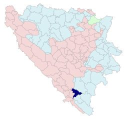 Location of Berkovići within Bosnia and Herzegovina | |
| Coordinates: 43°07′N 18°04′E / 43.117°N 18.067°ECoordinates: 43°07′N 18°04′E / 43.117°N 18.067°E | |
| Country | Bosnia and Herzegovina |
| Entity | Republika Srpska |
| Government | |
| • Mayor | Nenad Abramović (SDS) |
| Area | |
| • Total | 249.69 km2 (96.41 sq mi) |
| Population (2013 census) | |
| • Total | 2,114 |
| • Density | 8.5/km2 (22/sq mi) |
| Time zone | UTC+1 (CET) |
| • Summer (DST) | UTC+2 (CEST) |
| Area code(s) | 59 |
| Website |
www |
Berkovići (Serbian Cyrillic: Берковићи) is a village and municipality located in southern Republika Srpska, an entity of Bosnia and Herzegovina. As of 2013, it has a population of 2,114 inhabitants.
Geography
The municipality is located in the westernmost part of East Herzegovina.
History
The municipality was created in 1995, after the Bosnian War, out of the Republika Srpska-controlled portions of the pre-war municipality of Stolac (now in Federation of B&H).
Settlements
Aside from the town of Berkovići, the municipality includes the following settlements:
Berkovići also contains parts of the following settlements:
- Barane
- Burmazi
- Do
- Hodovo
- Hrgud
Demographic
According to 2013 census results, it has a population of 2,114 inhabitants.
Ethnic groups
- 2013 Census
| Municipality | Nationality | Total | |||||
|---|---|---|---|---|---|---|---|
Bosniaks |
% |
Croats |
% |
Serbs |
% | ||
| Berkovići | 159 | 7.52 | 11 | 0.52 | 1,942 | 91.86 | 2,114 |
Economy
The municipality is underdeveloped and much of the economic activity is agricultural.
See also
References
External links
| Wikimedia Commons has media related to Berkovići. |
This article is issued from
Wikipedia.
The text is licensed under Creative Commons - Attribution - Sharealike.
Additional terms may apply for the media files.