Tešanj
| Tešanj Тешањ | ||
|---|---|---|
| Town and municipality | ||
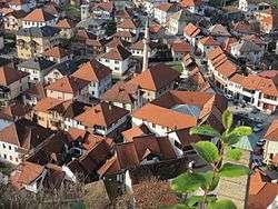 Heart of the Old town of Tešanj as seen from the castle | ||
| ||
 Location of Tešanj within Bosnia and Herzegovina. | ||
 Tešanj Location of Tešanj | ||
| Coordinates: 44°36′51.5″N 17°59′22.1″E / 44.614306°N 17.989472°E | ||
| Country | Bosnia and Herzegovina | |
| Government | ||
| • Municipality president | Suad Huskic (SDA) | |
| Area | ||
| • Total | 155,9 km2 (602 sq mi) | |
| Population (2013 census) | ||
| • Total | 43,063 | |
| • Density | 276.22/km2 (715.4/sq mi) | |
| Time zone | UTC+1 (CET) | |
| • Summer (DST) | UTC+2 (CEST) | |
| Area code(s) | +387 32 | |
| Website |
www | |

Tešanj is a town and municipality located in Zenica-Doboj Canton of the Federation of Bosnia and Herzegovina, an entity of Bosnia and Herzegovina. As of 2013, it has a population of 43,063 inhabitants. It is situated in the northern part of Bosnia and Herzegovina.
Geography
Tešanj is located at an altitude of 230 meters and developed around the river Tešanjka.
History
The present name of the city was mentioned for the first time in 1461 in a charter from King Stephen Tomašević to his uncle Radivoj. The charter stated that King Stephen Tomašević grants him, among other possessions "i na Usori grad Tešanj -- the city of Tešanj, in the Usora region".
Between the second half of the 15th century and the first half of the 16th century, the history of Tešanj was rather chaotic. Since Bosnia was considered a buffer state by the Ottomans, it changed rulers quite often, alternating between Ottoman and Hungarian occupation. Between 1463 and 1476 Tešanj was the center of the Bosnian kingdom and the residence of Duke Radivoj Kotromanić.

From 1512 (or 1520-21) on, Tešanj was under continuous rule of the Ottoman Empire. The most Ottoman influential ruler of Tešanj was the Bosnian Sandžak-bey Gazi Ferhad-bey. It was under his authority that the city rapidly developed. His most significant contribution was the Ferhadija Mosque (1563), which still stands in the old town, dating back to the 16th century. Gazi Ferhad-bey died in 1568 and was buried in the yard of the mosque. The epitaph on his tombstone was in Arabic, and is the oldest Islamic record in Tešanj.
The old Eminagić House is the oldest house in Tešanj, still standing the test of time, and is said to have been built at the end of the 17th century.
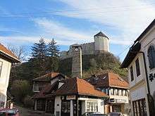
The Old Town is dominated by the well-preserved fortress, called "Gradina", that overlooks the entire city. The Upper City Center expands around the castle, rather on the bottom of this castle. Very early this castle became a center of economic and cultural life of Tešanj. This was developed along with retail and trade in Tešanj. The city center developed rapidly in the 17th and 18th century, when there were around 40 stores and trades operating.
The hour tower was built in the 17th century. Out of a total of 21 hour towers that were built throughout Bosnia and Herzegovina, this tower is one of four that are still working properly. It is 18.5 meters tall. Up until 1890 this tower showed alaturk time, but the same year Fehim-beg Smailbegović brought a new clock which showed European time. This hour clock is still working.
The grave of the poet Musa Ćazim Ćatić is located in "Obješenica" cemetery in the city center. Even though he was born in Odžak in 1880, he dedicated his whole life and work to the city Tešanj, where he died in 1915.
From 1929 to 1941, Tešanj was part of the Vrbas Banovina of the Kingdom of Yugoslavia.
Tourism
Tešanj Castle

The foundation of this fortification was started even before the Romans conquered the region. Exact dates are unknown. It was later enhanced by the Romans, Slavs and the Ottoman forces. It has been primarily a defensive fortification. Tešanj Castle is one of the most significant and biggest castles in Bosnia, with the area of some 6,296 square metres.
During the Ottoman period, the castle had a permanent army.
Demographics
| Ethnic Composition | |||||||||||||
| Year | Serb | % | Bosniaks | % | Croats | % | Yugoslavs | % | Others | % | Total | ||
|---|---|---|---|---|---|---|---|---|---|---|---|---|---|
| 1961 | 3,464 | 11.87% | 18,270 | 62.61% | 6,332 | 21.70% | 1,003 | 3.44% | 113 | 0.39% | 29,182 | ||
| 1971 | 2,692 | 7.76% | 24,208 | 69.78% | 7,603 | 21.92% | 39 | 0.11% | 151 | 0.44% | 34,693 | ||
| 1981 | 3,152 | 7.21% | 30,653 | 70.16% | 8,548 | 19.56% | 1,012 | 2.32% | 327 | 0.75% | 43,692 | ||
| 1991 | 3,078 | 6.36% | 34,938 | 72.20% | 8,952 | 18.50% | 1,038 | 2.15% | 384 | 0.79% | 48,390 | ||
| 2013 | 226 | 0.52% | 40,461 | 93.95% | 1,462 | 3.39% | 0.00 | 0.00% | 750 | 0.79% | 43,063 | ||
The town of Tešanj itself had 5,253 residents in 1981, and 6,058 in 1991. Note Muslims are Bosniaks.
Places in the municipality
Bukva, Blaževci, Bobare, Cerovac, Čaglici, Čifluk, Dobropolje, Drinčići, Džemilić Planje, Jevadžije, Jelah, Jablanica, Jelah-polje, Kalošević, Karadaglije, Koprivci, Kraševo, Lepenica, Logobare, Lončari, Ljetinić, Marin Han, Mrkotić, Miljanovci, Medakovo, Mekiš, Novo Selo, Novi Miljanovci, Oraš Planje, Piljužići, Potočani, Putešić, Raduša, Rosulje, Ripna, Šije, Tešanj, Trepče, Tešanjka, Tugovići, Vrela, Vukovo, Hrvatinovići[1]
Notable people
- Admir Ljevaković, footballer
- Ademaga Mešić, Ustaša Deputy-Leader
- Damat Ibrahim Pasha, Ottoman statesman
- Enis Bešlagić, actor
- Musa Ćazim Ćatić, poet
- Otto Lang, film producer
- Lazar Jovanović, 19th-century teacher and manuscript writer
- Jasmin Muharemović, singer
- Esad Muharemović, singer
- Edin Šaranović, footballer
- Ernad Turalić, professional billiards player
References
- ↑ Opcina Tesanj - zvanična web stranica Archived 2008-05-08 at the Wayback Machine.
External links
Municipalities of the Zenica-Doboj Canton | ||
|---|---|---|
Coordinates: 44°36′51.5″N 17°59′22.1″E / 44.614306°N 17.989472°E
| Wikimedia Commons has media related to Tešanj. |