Ključ, Una-Sana Canton
| Ključ Кључ | ||
|---|---|---|
| Town and municipality | ||
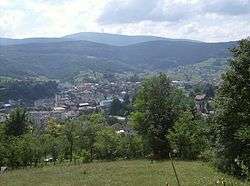 Panoramic view | ||
| ||
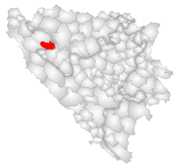 Location of Ključ within Bosnia and Herzegovina. | ||
| Country |
| |
| Entity |
| |
| Canton | Una-Sana | |
| Government | ||
| • Municipality president | Nedžad Zukanović (SDP) | |
| Area | ||
| • Total | 358 km2 (138 sq mi) | |
| Population (2013 census) | ||
| • Total | 18,714 | |
| Time zone | UTC+1 (CET) | |
| • Summer (DST) | UTC+2 (CEST) | |
| Area code(s) | +3873766XXXX | |
| Website | http://www.opcina-kljuc.ba | |

Ključ (pronounced [kʎûːtʃ]) is a town and municipality located in Una-Sana Canton of the Federation of Bosnia and Herzegovina, an entity of Bosnia and Herzegovina. The name of the town and the municipality translates to "Key" in Bosnian.
Geography
It is located a short distance south from Sanski Most. The Sana River runs through the municipality. The terrain is heavily forested.
History
Human settlements have existed in the area long before the Roman Era. The town itself is first mentioned in 1322 in the documents of ban Stjepan II Kotromanić. It was conquered by the Ottoman Empire in 1463 as the last Royal Bosnian fortress.
From 1929 to 1941, Ključ was part of the Vrbas Banovina of the Kingdom of Yugoslavia.
Kljuc was first mentioned in 1322. In 1463, during the Ottoman invasion of Bosnia, the last Bosnian king Stjepan Tomašević, took refuge in the city. His surrender and execution marked the downfall of the medieval Bosnian state.
As an area with a slight Serb majority, at the start of the war in Bosnia (1992-1995), the Ključ area was held by Bosnian Serb forces. In the summer of 1995, the Bosnian governmental forces took control over it. Most of the pre-war Serb population fled after the Dayton Peace Agreement, the town belongs to the Federation of Bosnia and Herzegovina. Today, it is estimated that about 97% of the population of Ključ are Bosniaks.
Settlements
In 1991, the municipality of Ključ contained 61 settlements:
- Biljani Donji
- Biljani Gornji
- Budelj Gornji
- Busije
- Crkveno
- Crljeni
- Čađavica
- Donja Previja
- Donja Slatina
- Donje Ratkovo
- Donje Sokolovo
- Donji Ramići
- Donji Ribnik
- Donji Vojići
- Donji Vrbljani
- Dragoraj
- Dubočani
- Gornja Previja
- Gornja Slatina
- Gornje Ratkovo
- Gornje Sokolovo
- Gornji Ramići
- Gornji Ribnik
- Gornji Vojići
- Gornji Vrbljani
- Hadžići
- Hasići
- Hripavci
- Humići
- Jarice
- Kamičak
- Ključ
- Kopjenica
- Korjenovo
- Krasulje
- Lanište
- Ljubine
- Međeđe Brdo
- Mijačica
- Peći
- Pištanica
- Plamenice
- Prhovo
- Prisjeka Donja
- Prisjeka Gornja
- Rastoka
- Rudenice
- Sanica
- Sanica Donja
- Sanica Gornja
- Sitnica
- Sredice
- Stražice
- Treskavac
- Velagići
- Velečevo
- Velijašnica
- Velije
- Zableće
- Zavolje
- Zgon
As a result of the war, the villages of Busije, Crkveno, Čađavica, Donja Previja, Donja Slatina, Donji Ribnik, Donji Vrbljani, Dragoraj, Gornja Previja, Gornja Slatina, Gornje Sokolovo, Gornji Ribnik, Gornji Vrbljani, Rastoka, Sitnica, Sredice, Stražice, Treskavac, Velijašnica, Velije et Zableće, as well as parts of Donje Ratkovo, Donje Sokolovo, Dubočani, Gornje Ratkovo, Jarice, Ljubine et Velečevo became a part of Ribnik municipality, Republika Srpska.
Today the municipality of Ključ has 40 settlements:
- Biljani Donji
- Biljani Gornji
- Budelj Gornji
- Crljeni
- Donje Ratkovo (part)
- Donje Sokolovo (part)
- Donji Ramići
- Donji Vojići
- Dubočani (part)
- Gornje Ratkovo (part)
- Gornji Ramići
- Gornji Vojići
- Hadžići
- Hasići
- Hripavci
- Humići
- Jarice (part)
- Kamičak
- Ključ
- Kopjenica
- Korjenovo
- Krasulje
- Lanište
- Ljubine (part)
- Međeđe Brdo
- Mijačica
- Peći
- Pištanica
- Plamenice
- Prhovo
- Prisjeka Donja
- Prisjeka Gornja
- Pudin Han
- Rudenice
- Sanica
- Sanica Donja
- Sanica Gornja
- Velagići
- Velečevo (part)
- Zavolje
- Zgon
Demographics
According to the last official census in 1991, the municipality had a key 37,233 inhabitants, distributed in 61 settlements.
| Ethnic Composition (2013) | ||||||
| Serbs | 273 (1.63%) | |||||
| Bosniaks | 16,130 (96.33%) | |||||
| Croats | 30 (0.17%) | |||||
Page text.[1]
| Ethnic Composition (1991) | ||||||
| Serbs | 18,438 (49.52%) | |||||
| Bosniaks | 17,714 (47.57%) | |||||
| Croats | 336 (0.90%) | |||||
| Yugoslavs | 545 (1.46%) | |||||
| others | 200 (0.55%) | |||||
| Ethnic Composition (1971) | ||||||
| Total | 39,966 | |||||
| Serbs | 23,892 (59.78%) | |||||
| Muslims (now Bosniaks) | 15,226 (38.09%) | |||||
| Croats | 534 (1.33%) | |||||
| Yugoslavs | 131 (0.32%) | |||||
| others | 183 (0.48%) | |||||
Economy
The area is connected to other parts of Bosnia by the M-5 highway. Forestry, light industry and tourism are major components of the economy.
References
External links
| Wikimedia Commons has media related to Ključ. |
Municipalities of the Una-Sana Canton | ||
|---|---|---|