Kladanj
| Kladanj Кладањ | |
|---|---|
| Town and municipality | |
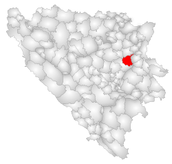 Location of Kladanj within Bosnia and Herzegovina. | |
 Kladanj Location of Kladanj | |
| Coordinates: 44°14′N 18°41′E / 44.233°N 18.683°E | |
| Country |
|
| Entity |
|
| Government | |
| • Municipality president | Jusuf Čavkunović (SDA) |
| Area | |
| • Total | 325 km2 (125 sq mi) |
| Elevation | 570 m (1,870 ft) |
| Population (=) | |
| • Total | 12,348 |
| Time zone | UTC+1 (CET) |
| • Summer (DST) | UTC+2 (CEST) |
| Area code(s) | +387 35 |
Kladanj is a town and municipality located in Tuzla Canton of the Federation of Bosnia and Herzegovina, an entity of Bosnia and Herzegovina. Kladanj is located on road from Tuzla to Sarajevo along the river Drinjača, at the base of Konjuh mountain.
History
The first mention of the town of Kladanj dates back to 1138.
The first record of Kladanj in Turkish sources is from 1469, referring to the market place Cetvrtkoviste where on Thursdays big fairs were held. In the period of Ottoman rule, Kladanj was mentioned in 1557, as a settlement (kasaba) within the Sarajevo kadiluk (territorial unit) that would further on become a kadiluk itself with Olovo as its part.[1]
Settlements
• Brateljevići • Brdijelji • Brgule • Brlošci • Buševo • Crijevčići • Dole • Gojakovići • Gojsalići • Goletići • Jelačići • Jošje • Kladanj • Konjevići • Kovačići • Krivajevići • Lupoglavo • Majdan • Mala Kula • Matijevići • Mladovo • Noćajevići • Novo Naselje - Stupari • Obrćevac • Olovci • Pauč • Pelemiši • Pepići • Plahovići • Prijanovići • Prijevor • Ravne • Rujići • Starić • Stupari - Centar • Stupari - Selo • Suljići • Tarevo • Tuholj • Velika Kula • Vranovići • Vučinići • Zagrađe
Demographics
1971
14,015 total
1991
16,070 total
- Bosniaks - 11,621
Demographic 2013 Census
| Municipality | Nationality | Total | |||||
|---|---|---|---|---|---|---|---|
Bosniaks |
% |
Croats |
% |
Serbs |
% | ||
| Kladanj | 11,997 | 97.15 | 33 | 0.26 | 107 | 0.86 | 12,348 |
Page text.[2]
Geography
The land area of the municipality is approximately 325 km2 (125 sq mi). The town is 570 meters above sea level.
Economy
The lumber industry called "Sokolina" is one of the most vital economic contributors to the municipality.
Notable people
- Sulejman Kupusović, film director
- Mirko Pejanović, member of the Presidency of the R BiH, as well as professor and dean of the Faculty of Political Sciences in Sarajevo
- Akif Šeremet, founder and secretary of the LCY[3]
- Avdaga Hasić, leader of the local militia "Avdaga's legion"[4]
- Senahid Halilović, professor of dialectology and author of "The Orthography of the Bosnian language"
References
- ↑ "Archived copy". Archived from the original on 2016-03-03. Retrieved 2009-03-30.
- ↑ Link text, additional text.
- ↑ Graovac, Dušan: "Crveni profesor Akif Šeremet", Samobor, 1982
- ↑ jugosfera (29 August 2013). "Kladanj - muška voda". Retrieved 20 April 2018 – via YouTube.
External links
| Wikimedia Commons has media related to Kladanj. |
Municipalities of the Tuzla Canton | ||
|---|---|---|
Coordinates: 44°14′N 18°41′E / 44.233°N 18.683°E
| Authority control |
|---|