Sanski Most
| Sanski Most Сански Мост | ||
|---|---|---|
| Town and municipality | ||
 | ||
| ||
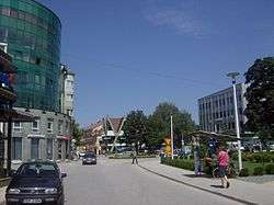
 Sanski Most Location of Sanski Most | ||
| Coordinates: 44°46′N 16°40′E / 44.767°N 16.667°ECoordinates: 44°46′N 16°40′E / 44.767°N 16.667°E | ||
| Country | Bosnia and Herzegovina | |
| Subdivisions | 75 | |
| Government | ||
| • Mayor | Faris Hasanbegović (SDA) | |
| Area | ||
| • Total | 781 km2 (302 sq mi) | |
| Population (2013 Census) | ||
| • Total | 41,475 | |
| • Density | 53.10/km2 (137.5/sq mi) | |
| Time zone | UTC+1 (CET) | |
| • Summer (DST) | UTC+2 (CEST) | |
| Area code(s) | +387 37 | |
| Website |
www | |
Sanski Most (pronounced [sâːnskiː mɔ̂ːst]) is a town and municipality located in Una-Sana Canton of the Federation of Bosnia and Herzegovina, an entity of Bosnia and Herzegovina. It is situated on the banks of Sana River in northwestern Bosnia and Herzegovina, in region of Bosanska krajina, between Prijedor and Ključ. As of 2013, it has a population of 41,475 inhabitants.
Geography
It is located on the Sana River in Bosanska Krajina, between Prijedor and Ključ. Administratively it is part of the Una-Sana Canton of the Federation of Bosnia and Herzegovina.
History
In 1878 the little town (varošica) of Sanski Most was described as Muslim by Croatian historian Vjekoslav Klaić.[1] From 1929 to 1941, Sanski Most was part of the Vrbas Banovina of the Kingdom of Yugoslavia.
During World War II it was part of the Axis Independent State of Croatia. At the beginning of May 1941 in several villages south-east of Sanski Most (Kijevo, Tramošnja, Kozica, etc.) the first armed conflict between the Ustaše and insurgent Serbs occurred. The event is known as the Đurđevdan uprising. The State Anti-fascist Council for the National Liberation of Bosnia and Herzegovina (ZAVNOBiH) held its second meeting from 30 June to 2 July 1944 in the town; it declared the equality of Muslims (Bosniaks), Serbs and Croats.
During the Bosnian War, the town was controlled by the Army of Republika Srpska (Bosnian Serbs) and remained under its control until October 1995 when the Army of Bosnia and Herzegovina took over it shortly before the end of the war.
In 1996, Serb-inhabited Oštra Luka was split from Sanski Most and ceded to the Republika Srpska entity.
Demographics
| Ethnic Composition | |||||||||||||
| Year | Serbs | % | Bosniaks | % | Croats | % | Yugoslavs | % | Others | % | Total | ||
|---|---|---|---|---|---|---|---|---|---|---|---|---|---|
| 1961 | 19,156 | 48.52% | 12,350 | 31.28% | 4,844 | 12.27% | 3,014 | 7.63% | % | 39,483 | |||
| 1971 | 30,422 | 48,98% | 24,839 | 39,99% | 6,307 | 10,15% | 195 | 0,31% | 339 | 0,57% | 62,102 | ||
| 1981 | 26,619 | 42.61% | 27,083 | 43.36% | 5,314 | 8.51% | 2,936 | 4.70% | 515 | 0,82% | 62,467 | ||
| 1991 | 25,363 | 42.05% | 28,136 | 46.65% | 4,322 | 7.16% | 1,247 | 2.06% | 1,239 | 2.08% | 60,307 | ||
| 2014 | 817 | 1.62% | 41,739 | 82.78% | 7,811 | 15.49% | n/a | n/a | 54 | 0.10% | 50,421 | ||
The size of the municipality's area more than doubled after 1961. Therefore, the population rose quite a bit.
The city of Sanski Most itself had 50,421 residents in 2014.
Economy
| Employment | Male | Female | Total | Total Population | Unemployment % |
|---|---|---|---|---|---|
| 2014 | 3,384 | 1,363 | 4,747 | 50,421 | 53.91%[2] |
Sanski Most is home to many different types of stores, and in the city center Konzum is located, part of a food chain from Croatia. There is also a store of the Tuš-chain of foodstores. There are many cafés in the city as well as many bakeries.
There are several non-governmental organisations in Sanski Most. Center for Peacebuilding, in the local language "Centar za Izgradnju Mira (CIM)" has been active in the city since 2004. The "Fenix Center", Centar Fenix provides humanitarian aid to the persons in need in the local community. The organisation "Krajiška Suza" is providing care in medical, social, psychological, cultural and existential needs of people living in and around Sanski Most.
Sport
The football club of the town is NK Podgrmeč.
Gallery
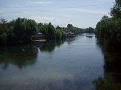 Sana river
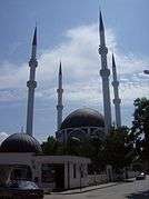 Hamzibey's mosque
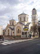 Orthodox church
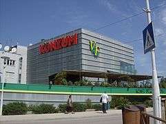 Supermarket Konzum
Notable people
- Sanjin Halimović, politician
- Milan Vukić, chess grandmaster
- Anna Ibrisagic, Swedish politician
- Enver Redžić, historian
- Kemal Malovčić, singer
- Milenko Zorić, Serbian sprint canoer, silver medalist at the 2016 Summer Olympics, World and European champion
- Vukašin Brajić, singer
See also
References
- ↑ Vjekoslav Klaić (1878). Bosna: podatci o zemljopisu i poviesti Bosne i Hercegovine. Naklad. "Matice Hrvatske". p. 192.
- ↑
External links
| Wikimedia Commons has media related to Sanski Most. |
- Official site
- http://www.sanskimost.com/
- http://www.sanski-most.info
- https://web.archive.org/web/20090106174502/http://www.sanskaognjista.org/
- Center for Peacebuilding web presence
- Krajiška Suza web presence
Municipalities of the Una-Sana Canton | ||
|---|---|---|