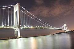
Verrazzano-Narrows Bridge
| Verrazzano-Narrows Bridge | |
|---|---|
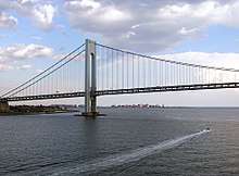
_under_the_Verrazano_Narrows_Bridge.jpg) The Verrazzano-Narrows Bridge, looking west toward Staten Island | |
| Coordinates | 40°36′23″N 74°02′44″W / 40.60639°N 74.04556°WCoordinates: 40°36′23″N 74°02′44″W / 40.60639°N 74.04556°W |
| Carries |
13 lanes of (7 lanes on upper level: 6 fixed-direction, 1 reversible HOV lane; 6 lanes on lower level) |
| Crosses | The Narrows |
| Locale | New York City (Staten Island–Brooklyn), New York, U.S. |
| Other name(s) |
Verrazano-Narrows Bridge Verrazzano Bridge Narrows Bridge |
| Maintained by | MTA Bridges and Tunnels |
| Characteristics | |
| Total length | 13,700 ft (4,176 m) |
| Width | 103 ft (31 m) |
| Height | 649.68 ft (198 m) |
| Longest span | 4,260 ft (1,298 m) |
| Clearance above |
15 ft (4.57 m) (upper level) 14.4 ft (4.39 m) (lower level) |
| Clearance below | 228 ft (69.5 m) at mean high water |
| History | |
| Designer | Othmar Ammann |
| Construction start | August 13, 1959 |
| Opened |
November 21, 1964 (upper level) June 28, 1969 (lower level) |
| Statistics | |
| Daily traffic | 202,523 (2016)[1] |
| Toll |
As of March 19, 2017: $11.52 (New York E-ZPass users outside Staten Island) $5.50 (Staten Island residents) $17.00 (all others; billed by mail) |
 Verrazzano-Narrows Bridge Location  Verrazzano-Narrows Bridge Verrazzano-Narrows Bridge (New York)  Verrazzano-Narrows Bridge Verrazzano-Narrows Bridge (the US) | |
The Verrazzano-Narrows Bridge (/vərɑːˈzɑːnoʊ/ ver-uh-ZAH-no), also referred to as the Verrazzano Bridge and formerly the Verrazano-Narrows Bridge and Narrows Bridge, is a double-decked suspension bridge that connects the New York City boroughs of Staten Island and Brooklyn and is named for Giovanni da Verrazzano. It spans the Narrows, a body of water linking the relatively enclosed Upper New York Bay with Lower New York Bay and the Atlantic Ocean. The bridge carries thirteen lanes of Interstate 278, with seven lanes on the upper level and six on the lower level. In 1524, da Verrazzano became the first documented European explorer to enter New York Harbor and the Hudson River.
Engineer David B. Steinman first proposed a bridge across the Narrows in 1927. Subsequent proposals of vehicular crossings across the Narrows were deferred over the next twenty years. A 1920s attempt to build a rail tunnel across the Narrows was aborted, as was another 1930s plan for vehicular tubes underneath the Narrows. Discussion of a tunnel resurfaced in the mid-1930s and early 1940s, but were again denied. In the late 1940s, urban planner Robert Moses championed a bridge across the Narrows as a way to connect Staten Island with the rest of the city. Various issues delayed the start of construction until 1959. The bridge opened on November 21, 1964, and a second deck beneath the existing span was opened in June 1969.
The Verrazzano-Narrows Bridge has a central span of 4,260 feet (1,298 m). It was the longest suspension bridge in the world from 1964 until it was surpassed by the Humber Bridge in the United Kingdom in 1981. The bridge has the 13th longest main span in the world, as well as the longest in the Americas. The bridge marks the gateway to New York Harbor. All ships arriving at the Port of New York and New Jersey pass underneath the bridge and must therefore be built to accommodate the clearance under it.[2]
Because of a naming error in the original construction contract, the bridge's name was originally spelled "Verrazano-Narrows Bridge" with only one "z" when it was officially named in 1960, despite the explorer's name having two "z"s.[2] In October 2018, after the bridge had been spelled incorrectly spelled for 58 years, the name of the bridge was officially corrected to "Verrazzano-Narrows Bridge".[3]
History
Early plans
A bridge across the Narrows had been proposed as early as 1927, when structural engineer David B. Steinman brought up the possibility of such a crossing.[4] At the time, Staten Island was isolated from the rest of New York City, and its only direct connection to the other four boroughs was via the Staten Island Ferry to South Ferry in Manhattan, or 39th and 69th Streets in Brooklyn.[5] In 1928, when the chambers of commerce in Brooklyn, Queens, Long Island, and Staten Island announced that the Interboro Bridge Company had proposed the future construction of the "Liberty Bridge" to United States Department of War. The bridge's towers would be 800 feet (240 m) high and it would cost $60 million in 1928 dollars.[6] In November 1929, engineers released plans for the 4,500-foot (1,400 m) Liberty Bridge spanning the Narrows,[7] with 800-foot-tall towers.[8] It was hoped that the new construction would spur development on Staten Island, along with the Outerbridge Crossing and the Bayonne Bridge, which were under construction at the time.[9]
The Liberty Bridge would carry vehicles from Bay Ridge to an as-yet-undetermined location on Staten Island.[9] On the Brooklyn side, the city planned to connect the Liberty Bridge to a "Crosstown Highway", spanning Brooklyn and Queens and connecting to the proposed Triborough Bridge in northwestern Queens. The city also envisioned a possible connection to the preexisting Manhattan Bridge, connecting Downtown Brooklyn to Lower Manhattan.[10]
A prior attempt to link Brooklyn and Staten Island, using the Staten Island Tunnel, had commenced in 1923 but was canceled two years later.[11][12] That tunnel would have extended subway service from Brooklyn to Staten Island.[13] This proposal was also revived with the announcement of the Liberty Bridge.[9][14] One of the alternative proposals had the subway tunnel going from St. George, Staten Island, to Bay Ridge, Brooklyn, before continuing to Governors Island and then Lower Manhattan.[14] Simultaneously, engineers proposed a set of vehicular tunnels from Fort Wadsworth, Staten Island, to 97th Street, Brooklyn.[15] The tubes were being planned in conjunction with the Triborough Tunnel (the modern-day Queens Midtown Tunnel), which would connect Manhattan, Brooklyn, and Queens.[16] The city appropriated $5 million for the tunnels in July 1929,[17] and the Baltimore and Ohio Railroad also pledged funding for the vehicular tunnels.[18] Planning for the vehicular tubes started that month.[16]
The Brooklyn Chamber of Commerce simultaneously considered all three projects—the bridge, the vehicular tunnels, and the subway tunnel. Community groups on both sides of the Narrows disagreed on which projects should be built first, if at all.[14] Residents of Bay Ridge opposed any plans involving a bridge because its construction would almost definitely require the demolition of part of the neighborhood.[19] Boring work for the vehicular tunnels started in November 1930. The 11,000-foot (3,400 m) twin tunnels, projected to be completed by 1937, were to connect Hylan Boulevard on Staten Island with 86th Street in Brooklyn once they were completed.[20] In January 1932, construction of these tunnels was put on hold indefinitely due to a lack of money.[21] The construction work did not go beyond an examination of shoreline on the Brooklyn side.[22]
In February 1933, the U.S. House of Representatives approved a bill authorizing the construction of a suspension bridge across the Narrows.[23] With this approval, the Interboro Bridge Company hoped to start constructing the bridge by the end of the year, thereby creating jobs for 80,000 workers.[24] Structural engineer Othmar H. Ammann, who was building the Triborough Bridge, Midtown Tunnel, and Golden Gate Bridge at the time, showed interest in designing the proposed Narrows bridge, which would be the world's longest bridge if it were built.[25] The city approved the construction of a rapid transit tunnel under the Narrows in December 1933. This tunnel was approved in conjunction with the proposed Brooklyn–Battery Tunnel connecting Red Hook with Lower Manhattan.[26]
In April 1934, the War Department announced its opposition to the Narrows Bridge's construction. The War Department's opposition to the bridge plan was based on the fact that a bridge could create a blockage during wartime, a rationale it gave for opposing a Brooklyn-Battery Bridge connecting Red Hook, Brooklyn, with Lower Manhattan.[27] The Port Authority of New York and New Jersey did not have a public position regarding the Narrows Bridge plan, other than a request that it be allowed to operate the future bridge.[28] Following the War Department's announcement that they would oppose the Narrows bridge, private interests began studying the feasibility of a tunnel under the Narrows.[22]
In 1936, the plan for a Narrows crossing was brought up again when New York City Mayor Fiorello H. La Guardia gained authorization to petition Congress for a bridge across the Narrows.[29] Under the new plan, the proposed bridge would charge tolls for motorists, and its $50 million cost would be paid off using federal bonds.[30] LaGuardia preferred a tunnel instead, and so the next year he requested the New York City Tunnel Authority to review the feasibility of such a crossing.[31] The New York City Planning Commission was amenable to constructing either a bridge or a tunnel across the Narrows, and in 1939, put forth a plan to expand New York City's highway system.[32][27] In March of the same year, as a bill for the Battery Bridge was being passed, Staten Island state legislators added a last-minute amendment to the bill, providing for a Narrows bridge.[33] The Narrows crossing was not included in the final version of the Planning Commission's plan, which was approved in 1941.[34]
In 1943, the New York City Board of Estimate allocated $50,000 toward a feasibility study of the tunnel.[35] By this time, Bay Ridge residents now opposed the tunnel plan as well, because they feared that the tunnel's construction would lower the quality of life in that neighborhood.[36] After the war ended in 1945, the Planning Commission estimated that construction of the Narrows Tunnel would cost $73.5 million.[37] However, by then, La Guardia had turned against the tunnel, saying that "it is not my time" to construct the tunnel.[37]
Plans finalized
The cancellation of plans for the Narrows tunnel brought a resurgence of proposals for a bridge across the Narrows. In September 1947, Robert Moses, the chairman of the Triborough Bridge and Tunnel Authority (TBTA), announced that the city was going to ask the War Department for permission to build a bridge across the Narrows.[38] Moses and Mayor William O'Dwyer both supported the Narrows Bridge plan, which was still being referred to as "Liberty Bridge".[39] The city submitted its request in July 1948,[40] and a commission composed of three United States Armed Forces branches was convened to solicit the public's opinions on the proposed span.[41]
U.S. Representative Donald Lawrence O'Toole, whose constituency included Bay Ridge, opposed the proposal for the bridge because he believed it would damage the character of Bay Ridge, and because the bridge might block the Narrows in case of a war.[42][43] He cited a poll showing that for every Bay Ridge resident who supported the bridge's construction, 33 more were opposed.[44] The U.S. military approved the proposal in May 1949, over the vociferous opposition of Bay Ridge residents, on the condition that construction start within five years.[45][44] By that time, plans for the 6,540-foot (1,990 m) span had been finalized, and the project only needed $78 million in financing in order to proceed. This financing was not set to be awarded until 1950, when the Battery Tunnel was completed. Preliminary plans showed the bridge as being 237 ft (72 m) above the mean high water level, enough for the 215-foot (66 m) RMS Queen Mary to pass under it.[46]
Moses and acting Port Authority Chairman Bayard F. Pope were agreeable to letting either of their respective agencies construct and operate the proposed Narrows Bridge, as long as that agency could do so efficiently. In 1954, the two agencies started conducting a joint study on the logistics of building and constructing the bridge. Because of restrictions by the TBTA's bondholders, construction could not begin until at least 1957.[47] Frederick H. Zurmuhlen, the Commissioner of Public Works, estimated that the Narrows Bridge would cost $200 million total.[48] He encouraged the TBTA to start construction on the bridge as soon as possible in order to reduce congestion on East River crossings to the north.[49] Staten Islanders viewed the project cautiously, since the Narrows Bridge would provide a connection to the rest of the city, but could also cause traffic congestion through the borough.[50] Moses had only a positive view of the bridge's proposed effects on Staten Islanders, saying that it was vital for the borough's future.[51]
In May 1954, the Army's permit for starting construction on the Narrows Bridge lapsed.[52] The Army granted a two-year extension for the start of construction.[53] In a measure passed in March 1955, the city gained control over the approval process for several tasks related to the Narrows bridge's construction, including land acquisition.[54] A little more than a month later, New York Governor W. Averell Harriman signed a $600 million spending bill authorizing the construction of the Narrows Bridge; the construction of the Throgs Neck Bridge between Queens and the Bronx; and the addition of a second level to the George Washington Bridge between Manhattan and New Jersey.[55] Later that year, it was announced that the Narrows Bridge would be part of an expansion to the Interstate Highway System.[56] Although a study on the viability of adding transit service to the Narrows Bridge was commissioned in early 1956,[57] Moses rejected the idea of adding subway tracks onto the new bridge, saying that it would be too costly.[58] In April of that year, New Jersey Governor Robert B. Meyner signed a bill that allowed the Port Authority to build the Narrows Bridge and lease it to the TBTA, who would operate the bridge.[59] The TBTA would buy the bridge from the Port Authority in 1967 as part of the agreement.[60]
On the Brooklyn side, the Narrows Bridge was originally supposed to connect to the Circumferential (Belt) Parkway, but in early 1957, Harriman vetoed a bill that stipulated that the main approach connect to the Belt Parkway.[61] By May 1957, an updated location for the Brooklyn anchorage had been agreed on. The anchorage was now to be located at Fort Lafayette, an island coastal fortification built next to Fort Hamilton at the southern tip of Bay Ridge.[62] Moses also proposed expanding Brooklyn's Gowanus Expressway and extending it to the Narrows Bridge by way of Seventh Avenue, which would require cutting through the middle of Bay Ridge. This proposal drew opposition from the community, who wanted the approach to follow the Belt Parkway along the Brooklyn shore.[63] These opponents said that the Seventh Avenue alignment would displace over 1,500 families.[64] In February 1958, the New York State Legislature approved a bill to change the Brooklyn approaches back to Belt Parkway, which was almost identical to the bill Harriman had vetoed.[65] However, the city approved the Seventh Avenue bridge approach in August 1958.[66] The next month, Mayor Robert F. Wagner Jr. said that the city was committed to building a bridge across the Narrows, but was not committed to the construction of the Seventh Avenue approach. In response, Moses wrote to Wagner that any continuing delays would cause the bridge to be canceled. The bridge's cost had now risen to $320 million.[67]
After holding a hearing for concerned Bay Ridge residents, the Board of Estimate affirmed the Narrows Bridge plan in October 1958,[64] without any objections.[68]:752 At the same time, it rejected plans for a tunnel under the Narrows, as well as a bridge or tunnel from Brooklyn directly to Jersey City, New Jersey.[64] The Board was set to vote on the Seventh Avenue approach in mid-December, but the federal government stated that it would only agree to the bridge's construction if the Seventh Avenue approach had 12 lanes, with six on each level.[69] The federal government was already paying for two highway improvements on both sides of the proposed bridge: the Clove Lakes Expressway on Staten Island, and the Gowanus Expressway in Brooklyn.[64] On December 31 of that year, the Board of Estimate voted to approve plans for the Seventh Avenue approach, having delayed that vote several times.[70]
The approval of the Seventh Avenue approach angered Bay Ridge residents since the construction of the approach would displace 7,500 people.[71] This amount of opposition was not matched in Staten Island, even though more than twice as many people were being displaced there, because the Staten Island Ferry was the only way to get between the island and the rest of the city. On the contrary, the bridge's announcement was welcomed because it sparked a rise in real-estate prices on the island.[72]:18–20 The State Legislature drafted a bill in an effort to change the approach's location to Belt Parkway.[73] However, New York Governor Nelson Rockefeller vetoed the Belt Parkway bill,[74] and in March 1959, the Board of Estimate officially condemned land along Seventh Avenue to make way for the Gowanus Expressway extension to the Narrows Bridge.[75] The only tasks remaining before the start of construction were to finalize the design of the Narrows Bridge, and to speed up the construction schedule to meet a 1964 deadline.[76] In April 1959, the bridge was officially renamed after the Italian navigator Giovanni da Verrazzano.[77] This sparked a controversy because the proposed bridge's name only had one "z" while the explorer's name had two "z"s.[78]
Construction
Surveying work for the Verrazano-Narrows Bridge began in January 1959.[72]:29 The official construction on the bridge began on August 14, 1959, with a groundbreaking ceremony on the Staten Island anchorage. Those in attendance included New Jersey Governor Meyner, New York City Mayor Wagner, and TBTA Chairman Moses. Although New York Governor Rockefeller had been invited to the event, neither he nor Assembly Speaker Joseph F. Carlino showed up.[60][72]:30 In December 1959, the TBTA was put in charge of funding and building the bridge.[79] To raise money for construction, Rockefeller signed a bill that would remove the 4% ceiling on the interest rates for the securities that the TBTA was selling to pay for the bridge. This ceiling would be lifted until June 1965. In essence, this meant that the TBTA could sell securities at much higher interest rates to raise the $320 million that was needed.[80]
The Swiss-born engineer Othmar Ammann was named as the senior partner for the project.[60] Other notable figures involved chief engineer Milton Brumer;[81][82] project engineers Herb Rothman and Frank L. Stahl;[83] design engineer Leopold Just;[84] Safety Engineer Alonzo Dickinson,[85] and engineer of construction John West Kinney.[83] Meanwhile, John "Hard Nose" Murphy supervised the span's and cables' construction.[72]:52[86]
Before starting actual work on the bridge, the TBTA destroyed the structures at the future locations of the anchorages.[60] The agency acquired 36 acres (15 ha) of the 138 acres (56 ha) within Fort Hamilton, in return for paying for a $12 million renovation of the Army installation and giving up 10.8 acres (4.4 ha) of land in Dyker Beach Park.[87] A 1,000-ton World War I monument on the Brooklyn side, within the path of the future Seventh Avenue approach, was placed atop rolling logs and shifted 370 ft (110 m).[88] The right-of-way for the Seventh Avenue approach was also being cleared, and despite initial opposition to the clearing work, all of the residents within the approach's path eventually acquiesced to moving elsewhere.[72]:24 To prevent contractors from delaying work on the expressways on either side of the bridge, Moses warned them of steep fines if the expressways were not completed by the time the bridge was finished.[89]
An anchorage was built on each side of the Narrows, with each anchorage measuring 229 ft (70 m) long by 129 ft (39 m) wide, with sixty-six large holes for the cables.[72]:54[90] Foundation work for the Verrazano-Narrows Bridge was well underway by 1960, as visitors were able to see the anchorages.[91] Then, two caissons were sunk into the channel close to either shoreline. The Staten Island side's caisson was sunk 105 ft (32 m) into the water, and necessitated the dredging of 81,000 cubic yards (62,000 m3) of sand and assorted muck.[72]:54 This caisson required 47,000 cu yd (36,000 m3) of concrete, and in March 1961, it became the first of the two caissons to be sunk.[90] The Brooklyn side's caisson required even more work, since it was 170 ft (52 m) deep, displaced 145,000 cu yd (111,000 m3) of muck, and used 83,000 cu yd (63,000 m3) of concrete.[72]:54[90] A concrete workers' strike in mid-1961 threatened the timely completion of the Staten Island anchorage, which had only been partially filled with concrete.[92] This strike lasted several months and affected many projects under the city.[93] The process of constructing the anchorages and caissons took just over two years, and it was complete by the end of 1961.[72]:54
Afterward, two separate companies constructed the modules that would make up the 693 ft-tall (211 m) suspension towers. The Staten Island tower was built by Bethlehem Steel, and the Brooklyn tower was built by the Harris Structural Company.[72]:55 The first piece of the towers, a 300-foot piece of the tower on the Staten Island side, was lifted into place in October 1961,[94] and this tower was topped out by September 1962.[95] The Brooklyn tower started construction in April 1962.[96] When the towers were fully erected, workers began the process of spinning the bridge's cables. The American Bridge Company was selected to construct the cables and deck.[72]:53 The cable-spinning process began in March 1963 and took six months, since 142,520 mi (229,360 km) of bridge cables had to be strung 104,432 times around the bridge.[97] The main cables were hung on both sides of the span, and then suspender cables were hung from the bridge's main cables.[72]:58 The main cables were fully spun by August.[98]
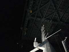
In late 1963, builders started receiving the rectangular pieces that would make up the roadway deck. The components for the sixty 40-ton slabs were first created in an assembly line in Jersey City.[99] Then, these components were combined in a Bayonne steelworks 5 mi (8 km) from the bridge site, and after the pieces of each slab were assembled, they were floated to the Narrows via barge.[100] Each piece measured 28 ft (8.5 m) high by approximately 115 ft (35 m) wide and long. These pieces of the deck were then hung from the suspender cables.[72]:94–95 The first piece of the deck was lifted onto the bridge in October 1963.[101] By early 1964, the span was nearly finished, and all that remained was to secure the various parts of the bridge.[72]:133 By this point, plans for new development on Staten Island were well underway,[102] and tourists had come to observe the construction of the Verrazano-Narrows Bridge.[103] The bridge had been scheduled to open in 1965, but as a result of the faster-than-anticipated rate of progress, the TBTA decided to open the bridge in November 1964.[104] In preparation for the Verrazano-Narrows Bridge's opening, the TBTA fully repainted the structure.[105] The construction process of the bridge had employed an average of 1,200 workers a day for five years, excluding those who had worked on the approaches; around 10,000 individuals had worked on the bridge throughout that five-year period.[68]:736
Three men died during the construction of the bridge.[72]:91 The first fatality was 58-year-old Paul Bassett, who fell off the deck and struck a tower in August 1962.[106] Irving Rubin, also 58 years old, died in July 1963 when he fell off of the bridge approach.[107][72]:91 The third worker who died was 19-year-old Gerard McKee, who fell into the water in October 1963 after slipping off the catwalk.[72]:91[108][109] After McKee's death, workers participated in a five-day strike in December 1963. The strike resulted in temporary safety nets being installed underneath the deck.[72]:98[110][111] These nets had not been provided during the four years prior to the strike.[111]
The construction of the bridge was chronicled by the writer Gay Talese in his 1964 book The Bridge: The Building of the Verrazano-Narrows Bridge. He also wrote several articles about the bridge's construction for the New York Times.[112] The book also contains several drawings by Lili Réthi and photographs by Bruce Davidson.[72]:Cover Page
Opening and early years
The Staten Island approach to the Verrazano-Narrows Bridge was the first part of the new project to be completed, and it opened in January 1964.[113] The upper deck was opened on November 21, 1964, at a cost of $320 million in 1964 dollars.[114] Politicians at all levels of the government, from Brooklyn Borough President Abe Stark to U.S. President Lyndon B. Johnson, wrote speeches paying tribute to the Verrazano-Narrows Bridge.[115] The opening ceremony was attended by over 5,000 people, including 1,500 official guests. Several dignitaries, involving the mayor, the governor, and the borough presidents of Brooklyn and Staten Island, cut the gold ribbon. They then joined a motorcade to mark the official opening of the bridge. A 35-cent toll was charged to all motorists crossing the bridge.[116][114] The Verrazano Bridge's opening was celebrated across Staten Island.[117] Moses did not invite any of the 12,000 workers to the opening,[111] so they boycotted the event and instead attended a mass in memory of the three workers who died during construction.[114]
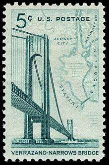
The opening was accompanied by the release of a commemorative postage stamp, which depicted a ship sailing underneath the new span.[118] The Metropolitan Transportation Authority (MTA) created a bus route across the bridge to connect Victory Boulevard in Staten Island with the Bay Ridge–95th Street subway station in Brooklyn.[119] This bus service initially saw low patronage, with only 6,000 daily passengers using the route.[120] Five days after the Verrazano-Narrows Bridge opened, the ferry from Staten Island to Bay Ridge, Brooklyn, stopped running, as it was now redundant to the new bridge.[121]
Within the first two months of the bridge's opening, 1.86 million vehicles had used the new crossing, 10% more than originally projected, and this netted the TBTA almost $1 million in toll revenue. The Goethals Bridge, which connected New Jersey to the Staten Island Expressway and the Verrazano Bridge, saw its daily average use increase by 75%, or approximately 300,000 trips total, compared to before the Narrows Bridge opened. The Holland Tunnel from New Jersey to Manhattan, and the Staten Island Ferry from Staten Island to Manhattan, both saw decreased vehicle counts after the bridge opened.[122] In summer 1965, Staten Island saw increased patronage at its beaches, facilitated by the opening of the new bridge.[123] By the time of the bridge's first anniversary, 17 million motorists had crossed the Verrazano-Narrows Bridge, paying $9 million in tolls.[124] The bridge had seen 34% more trips than planners had projected.[125] Conversely, 5.5 million fewer passengers and 700,000 fewer vehicles rode the Staten Island Ferry to Manhattan.[126]
The Verrazano Bridge was the last project designed by Ammann, who had designed many of the other major crossings into and within New York City. He died in 1965, the year after the bridge opened.[127] The Verrazano-Narrows Bridge was also the last great public works project in New York City overseen by Moses.[128] The urban planner envisioned that the Verrazano and Throgs Neck Bridges would be the final major bridges in New York City for the time being, since they would complete the city's expressway system.[129]
Additional deck and later years
Although the bridge was constructed with only one 6-lane roadway, Ammann had provided extra trusses to support a potential second roadway underneath the main deck.[130] These trusses, which were used to strengthen the bridge, were a design alteration that was added to many bridges in the aftermath of the Tacoma Narrows Bridge collapse in 1940.[72]:45 The Verrazzano-Narrows Bridge became so popular among motorists that in March 1969, the TBTA decided to erect the lower deck[131] at a cost of $22 million.[68]:1130 The Verrazzano Bridge had not been expected to carry enough traffic to necessitate a second deck until 1978, but traffic patterns over the previous five years had demonstrated the need for extra bridge capacity. By contrast, a lower deck on the George Washington Bridge, connecting New Jersey and Upper Manhattan, had not been built until thirty-one years after the bridge's 1931 opening.[132] The new six-lane deck opened on June 28, 1969.[133] Originally, the Verrazzano Bridge's Brooklyn end was also supposed to connect to the planned Cross-Brooklyn Expressway, New York State Route 878, and JFK Airport, but the Cross-Brooklyn Expressway project was canceled in 1969.[134]
On June 26, 1976, to celebrate the United States' 200th anniversary, workers placed a very large U.S. flag on the side of the Verrazzano Bridge.[135] The flag, which measured 193 by 366 ft (59 by 112 m),[136] was described in The New York Times as being the size of "a football field and a half"[135] and billed as the world's largest flag.[137] At the time, it was the largest U.S. flag ever made.[111] The flag was supposed to withstand wind speeds of 30 miles per hour (48 km/h), but it ripped apart three days later, when there was a wind speed of 16 mph (26 km/h).[137] The flag had been stuck against the bridge's suspender cables, so any slight wind would have caused the cables to make tears in the flag.[136] A second flag was created in 1980 for the July 4 celebration that year. This flag was even larger at 411 by 210 ft (125 by 64 m) (an area of 71,000 sq ft (6,600 m2)). The new flag was placed along a steel grid so that the suspender cables would not rip it apart.[136] Architectural critic Ada Louise Huxtable derided the new flag as a "simple-minded, vainglorious proposal" and asked, "Does anyone really want to spend $850,000 to upstage the Statue of Liberty?"[138][139]
The TBTA's successor, MTA Bridges and Tunnels, stopped collecting tolls for Brooklyn-bound drivers on the Verrazzano Bridge in 1986, and doubled the toll for Staten Island-bound drivers.[140] This was a result of a bill introduced by Guy V. Molinari, the U.S. Representative for Staten Island, as part of an initiative to reduce traffic that accumulated at the toll booth on Staten Island.[141] The one-way toll was initially intended to be part of a six-month pilot program,[142] but resulted in permanent changes to traffic flows on the Verrazzano Bridge. The crossing saw more Brooklyn-bound traffic and less Staten Island-bound traffic as a result.[143] This unidirectional collection remained in effect through the 21st century..[144]
Beginning in 2008, all 262 of the mercury vapor fixtures in the bridge's necklace lighting were replaced with energy-efficient light-emitting diodes. This retrofit was completed in 2009, years before LED street lights were installed in the rest of the city.[145]
The Verrazzano-Narrows Bridge's name was originally spelled with one "z". The "Verrazano" name dates to 1960 when Governor Rockefeller had signed the bill authorizing the bridge's name as such.[146] A bill to formally change the bridge's name to the variant with two "z"s was introduced by college student Robert Nash in 2016,[147] but stalled the next year,[148] as did another bill in early 2018.[149] The New York State Senate voted to change the name of the bridge in June 2018,[149] and the name change was officially signed into law that October.[3][150]
Renovation
.jpg)
In 2014, the city began a $1.5 billion reconstruction project on the bridge. At the time, it was expected to take up to 25 years.[151] The first phase, which cost $235 million and lasted until 2017, included replacing ramps, removing the divider on the upper deck, and adding a seventh lane on the upper deck, which was to be used as a high-occupancy vehicle (HOV) lane.[152] The parts for this deck were ordered from China because the parts that the MTA required were no longer manufactured in the United States.[153]
After the upper deck was replaced, parts of the lower deck are to be replaced, but this necessitates the closure of the lower deck during construction. Hence, the MTA opted to replace the upper deck first to add more capacity. The Brooklyn ramps to the bridge are also being rebuilt.[151] The upper level's new HOV lane opened in July 2017.[154] Simultaneously, the MTA dismantled the Staten Island-bound toll booths to speed up westbound traffic.[155] This work was done in advance of the reconstruction of tracks around Penn Station, which severely limited rail service into that station and created more vehicular traffic at crossings to Manhattan.[156] Long-term plans also call for the installation of a bicycle and pedestrian path on the Verrazzano-Narrows Bridge.[157]
Description
The Verrazzano-Narrows Bridge is owned by Triborough Bridge and Tunnel Authority bondholders who paid for the bridge at its construction.[158] It is operated by the TBTA's successor, MTA Bridges and Tunnels, which is an affiliate agency of the MTA.[159] The bridge carries Interstate 278, which continues onto the Staten Island Expressway to the west and the Gowanus Expressway to the northeast. The Verrazzano, in combination with the Goethals Bridge and the Staten Island Expressway, created a new way for commuters and travelers to reach Brooklyn, Long Island, and Manhattan by car from New Jersey.[160]
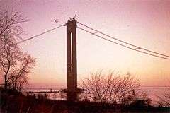
Each of the two suspension towers contains around 1 million bolts and 3 million rivets.[2] The diameters of each of the four main suspension cables is 36 in (914 mm). Each main cable is composed of 26,108 wires amounting to a total of 142,520 mi (229,364 km) in length.[2][97] Because of the height of the towers (693 ft or 211 m) and their distance from each other (4,260 ft or 1,298 m), the curvature of the Earth's surface had to be taken into account when designing the bridge. The towers are not parallel to each other, but are 1 5⁄8 in (41.275 mm) farther apart at their tops than at their bases.[68]:752[2][161] The bridge's suspension towers are the tallest structures in New York City outside of Manhattan.[111]
At the time of opening, the Verrazzano-Narrows Bridge was the longest suspension bridge in the world, with a center span of 4,260 ft (1,300 m), surpassing the length of the Golden Gate Bridge's center span by 60 ft (18 m).[72]:5 In 1981, it was surpassed by the Humber Bridge in England, which has a center span of 4,626 ft (1,410 m).[162]
Because of thermal expansion of the steel cables, the bridge roadway is 12 feet (3.66 m) lower in summer than in winter.[2][111][163] The bridge is affected by weather more than any other bridge in the city because of its size and isolated location close to the open ocean; it is occasionally closed, either partially or entirely, during strong wind and snow storms.
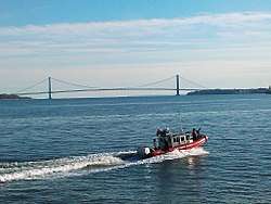
The Narrows is the only entry point for cruise ships and container ships that dock in New York City. As a result, they must be built to accommodate the clearance under the bridge. At mean high water, that clearance is 228 ft (69 m).[82] The RMS Queen Mary 2, one such vessel built to Verrazzano-Narrows Bridge specifications, was designed with a flatter funnel to pass under the bridge, and has 13 ft (3.96 m) of clearance under the bridge during high tide.[2][164]
Numerous birds nest or roost on the bridge, most notably breeding peregrine falcons.[165] The falcons nest at the top of the Verrazzano-Narrows Bridge's towers, as well as on the Throgs Neck and Marine Parkway Bridges. As the falcons are endangered, the city places bands on each bird and examines the birds' nesting sites each year. The falcons were discovered on the top of the Verrazzano Bridge in 1983, though they had started breeding there several years prior.[166][167]
Naming
Tentative names
During the planning stages, the bridge was originally named simply the "Narrows Bridge".[168] The co-naming of the bridge for Verrazzano (with two "z"s) was controversial. It was first proposed in 1951 by the Italian Historical Society of America, when the bridge was in the planning stage. After Robert Moses turned down the initial proposal, the society undertook a public relations campaign to re-establish Verrazzano's largely forgotten reputation and to promote the idea of naming the bridge for him. The society's director, John N. LaCorte, successfully lobbied several governors of states along the U.S.'s East Coast to proclaim April 17, the anniversary of Verrazzano's arrival in the harbor, as Verrazzano Day. LaCorte then approached the TBTA again, but was turned down a second time. The manager of the authority, backed by Moses, said the name was too long and that he had never heard of Verrazzano.[169] The explorer's name had previously been suggested for the George Washington Bridge, located several miles north, in 1931.[170]
The Italian Historical Society later successfully lobbied to get a bill introduced in the New York State Assembly to name the bridge for the explorer. After the introduction of the bill, the Staten Island Chamber of Commerce joined the society in promoting the name. In April 1958, Governor W. Averell Harriman announced that he would propose naming the Narrows Bridge after Verrazzano in honor of the explorer's voyage to the New York Harbor in 1524.[171] His successor, Nelson Rockefeller, put his support behind the one-"z" "Verrazano" name in April 1959, saying that it was the Americans' standard way of spelling the explorer's name.[77] According to Gay Talese, the one-"z" name was bolstered by the fact that it appeared on the bridge's first construction contracts in 1959; this incorrect spelling persisted in all subsequent references to the bridge.[148]
Although the "Verrazano" name was not finalized yet, the New York Times noted that the Staten Island Ferry boat carrying dignitaries to the bridge's August 1959 groundbreaking ceremony was named the "Verrazzano". The Times further stated that former Governor Harriman and Mayor Wagner had respectively proposed a "Verrazzano Bridge" and proclaimed a "Verrazzano Day".[78] The Staten Island Chamber of Commerce opposed the Verrazzano name altogether, saying that the proper name of the bridge should be "Staten Island Bridge" because there was also a "Brooklyn Bridge", a "Manhattan Bridge", a "Queens Bridge", and a "Bronx Bridge".[172] The Italian Historical Society was reportedly perplexed about the opposition to the "Verrazano" name.[173] In response to the Staten Island Chamber of Commerce's opposition, the TBTA offered to add a hyphen between "Verrazano" and "Narrows".[168]
Official name with one "z"
Rockefeller signed the "Verrazano" name into law in March 1960, which officially changed the name of the Narrows Bridge to "Verrazano-Narrows Bridge".[146] The naming issue did not encounter any more controversy until 1963, after the assassination of President John F. Kennedy. This prompted a series of suggestions to rename structures, monuments, and agencies across the United States after the late president.[174] A petition to rename the Verrazano Bridge for Kennedy received thousands of signatures.[175] In response, LaCorte contacted the president's brother, United States Attorney General Robert Kennedy, who told LaCorte that he would assure that the bridge would keep the "Verrazano" name.[169] Ultimately, the Verrazano-Narrows Bridge kept its name, while Idlewild Airport in Queens was renamed after Kennedy.[176]
In part due to discrimination against Italian-Americans, the bridge's official name was widely ignored by local news outlets at the time of the dedication. Some radio announcers and newspapers omitted any reference to Verrazzano, referring to the bridge as the Narrows Bridge, or the Brooklyn–Staten Island Bridge. The society continued its lobbying efforts to promote the name in the following years until the name became firmly established. Another ethnic slur for bridge was its nickname as the "Guinea Gangplank", referring to the Italian-Americans who subsequently moved from Brooklyn to Staten Island.[72]:33 The Italian Historical Society's published references to the bridge's name all contained two "z"s.[177]
Bills to change bridge's name
In June 2016, St. Francis College student Robert Nash started a petition to correctly spell Giovanni da Verrazzano's name on the bridge with two "z"s.[147][178][179][180] The petition gained support from politicians including New York State Senators Martin Golden and Andrew Lanza. The petition was also supported by actors and celebrities of Italian heritage, including Robert DeNiro, Tony Gemignani, and Joe D'Onofrio.[181] In December 2016, Senators Golden and Lanza sent letters to the Metropolitan Transportation Authority CEO Thomas F. Prendergast, in which they recommended that the bridge's name be spelled correctly. An MTA spokesperson said the agency was reviewing the letter.[181][182]
A bill to formally change the bridge's name stalled in 2017,[148] as did another bill in early 2018.[149] In mid-2018, Golden sponsored a New York State Senate bill to change the bridge's spelling to "Verrazzano" with two "z"s. On June 6 of that year, the Senate unanimously passed a bill to change the spelling of the Verrazano-Narrows Bridge, sending the measure to the New York State Assembly and the office of New York Governor Andrew Cuomo for approval. If the bill was passed, the MTA would modify nearly a hundred road signs at a cost of $350,000.[183][149] The Assembly passed the bill on June 21, sending the measure to Governor Cuomo with a minor modification. As a cost-saving measure, existing signs would retain the one-"z" spelling and would only be replaced by new signs with the double-"z" spelling when necessary.[184][150] On October 1, 2018, Governor Cuomo signed the bill into law, effectively changing the legal spelling of the bridge to the "Verrazzano-Narrows Bridge".[3][185][150]
Tolls
As of March 19, 2017, drivers traveling westbound into Staten Island pay $17.00 per car or $7.00 per motorcycle; eastbound drivers entering Brooklyn pay no toll. E-ZPass users with transponders issued by the New York E-ZPass Customer Service Center pay $11.52 per car or $5.00 per motorcycle; a five-axle truck pays $92, or $56.80 with NY E-ZPass. There is a Staten Island Resident Program that provides a discounted rate of $5.50 to registered residents of Staten Island using E-ZPass. Holders of transponders issued elsewhere get no discount. All E-ZPass users with transponders not issued by the New York E-ZPass Customer Service Center are required to pay the Toll-by-mail rates.[144] The $17 tolls for passenger cars, imposed in 2017, were higher than for most other tolled crossings in the U.S. Tolls for trucks ranged up to $132, or $79.52 with E-ZPass depending on the number of axles. As of 2017, the tolls from the Verrazzano-Narrows Bridge grossed the MTA $417 million per year, and about 85% of bridge motorists use the discounted toll rate.[186]
One-way toll
An urban legend has it that tolls were to be abolished once the bridge's construction bonds were paid off, but this has been debunked by the Staten Island Advance.[187][188] Originally, all drivers paid the same toll to cross the Verrazzano-Narrows Bridge. Staten Island residents were the only residents of New York City who had to pay a toll in order to enter their home borough, since all four of Staten Island's vehicular crossings collected tolls. This put Staten Island motorists at a financial disadvantage compared to drivers who lived in other boroughs.[189][190][186] A bill to reduce the tolls for Staten Islanders was introduced in the New York City Council in 1975.[189] Governor Mario Cuomo, the father of future Governor Andrew Cuomo, signed another law to give Staten Island residents discounted tolls in 1983, after years of petitioning and opposition from his two predecessors.[190]
From its opening until 1986, the toll was collected in both directions. In 1985, U.S. Representative Guy V. Molinari co-sponsored a bill that would require the MTA to collect the Verrazzano-Narrows Bridge's toll in the Staten Island-bound direction only. This came after Staten Island residents had complained about pollution from idling vehicles.[141] In December of that year, the United States House of Representatives passed a bill that prohibited the MTA from collecting tolls from Brooklyn-bound vehicles,[191] under penalty of a loss of highway funding.[143] Accordingly, in March 1986, the MTA started a pilot program where it charged a $3.50 toll for Staten Island-bound vehicles rather than charging a $1.75 toll in both directions.[140][192] The pilot program was extended to six months, but it was controversial due to the dubious benefits involved.[142] The new toll plan not only caused a drop in revenues,[193] but also caused congestion in Manhattan and Brooklyn[194] and air pollution in Manhattan. Canal Street in Lower Manhattan, which connected to the Holland Tunnel to New Jersey, saw the most severe congestion, as drivers would go through New Jersey and use the Bayonne Bridge to pay a cheaper toll to enter Staten Island.[195] Fatal accidents involving pedestrians in Lower Manhattan also increased greatly as a result.[196]
In 1987, the MTA supported removing the one-way toll because it reduced MTA revenues by $7 million a year.[197] At that point, Cuomo proposed reinstating an eastbound toll for trucks.[198] In 1990, it was noted that about 455,000 more eastbound vehicles per year were using the bridge's eastbound lanes compared to before the toll reconfiguration, but that this was heavily outweighed by the 1.5 million fewer westbound vehicles per year.[143] Residents of Manhattan and Brooklyn wanted the tolls changed so that either eastbound vehicles only, or both directions, would be tolled.[199]
E-ZPass was introduced at the Verrazzano-Narrows Bridge in late 1995.[200][201] Its introduction helped to reduce traffic congestion at the tollbooths; in March 1997, it was found that drivers with E-ZPass were able to pass through the westbound tollbooths within 30 seconds, compared to 15 minutes for rivers paying with tokens or cash.[202] In February 1998, the MTA discontinued the sale of toll tokens on the Verrazzano-Narrows Bridge, except to Staten Island residents purchasing them in bulk.[203]
Tollbooth removals
Despite not collecting tolls in the eastbound direction since 1986, the MTA did not do anything with the unused booths for a quarter-century.[204] In 2010, eight of the eleven Brooklyn-bound toll booths were removed as part of the first phase of a project to improve traffic flow at the toll plaza.[205][204] Two years later, the last of the eastbound tollbooths was removed.[206][207] Tolls are still collected only in the Staten Island-bound direction, and congestion within Lower Manhattan persists due to the bridge's one-way westbound toll.[144][186]
Open-road cashless tolling began on July 8, 2017.[155] The westbound tollbooths were also dismantled, and drivers were no longer able to pay cash at the bridge. Instead, there are cameras mounted onto new overhead gantries near where the booths were located.[208][209] Drivers without E-ZPass will have a picture of their license plate taken, and the toll will be mailed to them. For E-ZPass users, sensors will detect their transponders wirelessly.[208][209]
Bridge usage
In 2015, an average of 202,523 vehicles used the Verrazzano-Narrows Bridge daily in both directions. As of 2015, the Verrazzano-Narrows Bridge carries more traffic than the Outerbridge Crossing, the Bayonne Bridge, and the Goethals Bridge. These three bridges, which connect Staten Island with New Jersey, were used by a combined 168,984 vehicles in both directions.[1]
In 2011, advocacy group Transportation for America rated the Verrazzano-Narrows Bridge as New York's most dangerous, because of the combination of deterioration and the amount of people who cross it per day.[210] The MTA responded that the Verrazzano-Narrows Bridge, which was both the newest large bridge and the longest bridge in the state, was structurally sound, and that the bridge had passed its most recent inspection. The MTA attributed Transportation for America's results to a "misinterpretation of inspection records".[211]
Signs at both ends of the Verrazzano-Narrows Bridge forbid photography and video taping while on the bridge. These signs were installed after the September 11, 2001, attacks, when the MTA started confiscating film from individuals who were caught filming MTA crossings. However, the ban had been in place long before the attacks in order to prevent people from taking close-up pictures of the bridge.[212]
Public transportation
Three local bus routes operated by MTA Regional Bus Operations use the Verrazzano-Narrows Bridge: the S53 local route, the S79 Select Bus Service route, and the S93 limited-stop route. The bridge also carries 19 express bus routes that connect Staten Island with Manhattan and are also operated by New York City Transit. They are the SIM1, SIM1C, SIM2, SIM3, SIM3C, SIM4, SIM4C, SIM4X, SIM5, SIM6, SIM7, SIM9, SIM10, SIM15, SIM31, SIM32, SIM33, SIM34, and SIM35.[213]
Subway tracks were proposed for the bridge early in the planning process,[57] but Moses rejected them, ostensibly over cost concerns.[58] Other bridges proposed and built by Moses, including the Triborough Bridge, Henry Hudson Bridge, Bronx-Whitestone Bridge, and Throgs Neck Bridge, also lack provisions for subway tracks. According to biographer Robert Caro, Moses purposely excluded any provisions for mass transit on his bridges in order to promote private transportation.[214]
Pedestrian and bicycle prohibition
The Verrazzano-Narrows Bridge was not built with a pedestrian walkway because it was seen as too expensive, and because planners believed the lack of a walkway would help prevent possible suicide jumps.[215] Non-motorized transportation is limited to using the bridge during the New York City Marathon and Five Boro Bike Tour.[216][217] In 1976, the Verrazzano-Narrows Bridge was designated as the starting point of the New York City Marathon. The 1976 marathon was the first year in the marathon's six-year history that the New York City Marathon course went outside Manhattan.[218] Since then, the marathon has started at the Verrazzano Bridge's Staten Island end every year.[219] The Verrazzano-Narrows Bridge is not open to pedestrians or bikers outside of the marathon and the bike tour.[216]
The lack of a walkway did not stop suicides completely, since by 1975, four people had died after jumping off the bridge.[220] The number of suicides has increased over time, despite efforts at deterrence. A sign that says "Life Is Worth Living" is located on the Staten Island approach. In 2008, the MTA also installed six suicide hotlines on the bridge.[221]
There have been calls for a walkway or bike lane on the Verrazzano-Narrows Bridge since its opening, when several people protested over the lack of bike lanes at the bridge's opening ceremony.[222] In 1977, as a temporary solution, the city modified three buses to fit 12 bikes and 20 passengers each, then operated these buses on a new "S7 Verrazano Bridge" route.[223] In 1993, the New York City Department of City Planning called for a footpath across the bridge as part of their Greenway Plan for New York City.[224] The next year, the city sought a $100,000 federal grant to fund a feasibility study into a Verrazzano Bridge pedestrian and bike path.[225] In 1997, the DCP released its study, which found that two footpaths running between the suspender ropes along the upper level, separated for pedestrian and cyclist use, would cost a minimum of $26.5 million.[226][227] The MTA at the time expressed concern about the "safety and liability inherent in any strategy that introduces pedestrian and bicycle access" to the bridge.[226]
Local residents on both side of the bridge started advocating for the construction of a walkway or bikeway on the Verrazzano-Narrows Bridge in 2002. Dave Lutz, the director of the Neighborhood Open Space Coalition nonprofit, stated that after the September 11 attacks, Staten Islanders walked home along the bridge's roadway.[228] Mayor Michael Bloomberg promised to look into the possibility in October 2003.[229]
The Harbor Ring Committee was formed in 2011 to advocate for the completion of the Harbor Ring route, which would create a 50-mile (80 km) around New York Harbor, including a footpath across the Verrazzano.[227] In spring 2013 the committee began an online petition that generated more than 2,500 signatures, as well as an organizational sign-on letter with the support of 16 regional and local advocacy and planning organizations.[230] That year, the MTA announced that it would include conduct a three-year feasibility study for installing a pathway on the Verrazzano-Narrows Bridge.[227][231] The MTA considered plans for a bike lane in 2015, during the reconstruction of the Verrazzano-Narrows Bridge.[157]
References
- 1 2 "New York City Bridge Traffic Volumes" (PDF). New York City Department of Transportation. 2016. p. 11. Retrieved March 16, 2018.
- 1 2 3 4 5 6 7 Adler, Herry (November 2014). "The History of the Verrazano-Narrows Bridge, 50 Years After Its Construction". Smithsonian magazine. Smithsonian Institution. Retrieved November 21, 2014.
- 1 2 3 Campanile, Carl. "Cuomo Finally Fixes a 50-Year-Old Typo". Retrieved October 1, 2018.
- ↑ "ASKS SUBURBAN AID IN REGIONAL PLAN; Committee Urges Cooperation in Furthering Important Public Improvements. WANT COUNTIES TO HELP Transit, Bridges, Skyscrapers and Financing Among the Subjects Discussed". The New York Times. June 7, 1927. ISSN 0362-4331. Retrieved March 14, 2018.
- ↑ "The Future Staten Island". Brooklyn Daily Eagle. September 28, 1924. p. 65. Retrieved September 19, 2017 – via Newspapers.com.
- ↑ "OFFER TO SPAN NARROWS; Four Ccmmerce Chambers Would Later Give Bridge to City". The New York Times. May 2, 1928. ISSN 0362-4331. Retrieved March 13, 2018.
- ↑ "Span of 4,500 Feet in Narrows Bridge; Proposed $60,000,000 Bridge Over Narrows". The New York Times. November 17, 1929. ISSN 0362-4331. Retrieved March 13, 2018.
- ↑ "TOWERS OF BRIDGE TO RISE 800 FEET; D.B. Steinman, Engineer, Tells Steel Institute of Huge Harbor Span Planned Here. CHIMES AT EACH PINNACLE Liberty Bridge Beacons to Shine at Night From Height Greater Than Woolworth Building. Pledge Support to Hoover". The New York Times. November 14, 1929. ISSN 0362-4331. Retrieved March 13, 2018.
- 1 2 3 "SAYS BRIDGES BOOM REALTY IN RICHMOND; Many Industrial Firms Are Seeking Staten Island Sites, Says Real Estate Operator.NEW SPANS HELP VALUESGreat Commercial Centre in FiveYears Is Predicted--HoldingsSought Near Plaza Site". The New York Times. January 1, 1928. ISSN 0362-4331. Retrieved March 13, 2018.
- ↑ "Crosstown Highway Brooklyn Hope to Avert Great Industrial Crisis; Key to Traffic Congestion Relief". Brooklyn Daily Eagle. January 20, 1929. p. 51. Retrieved March 14, 2018 – via Brooklyn Public Library; newspapers.com.
- ↑ Pitanza, Marc (2015). Staten Island Rapid Transit Images of Rail. Arcadia Publishing. ISBN 978-1-4671-2338-9.
- ↑ Young, James C. (May 10, 1925). "Staten Island Waits for Narrows Tunnel" (PDF). The New York Times. Retrieved June 27, 2015.
- ↑ Raskin, Joseph B. (November 1, 2013), The Routes Not Taken: A Trip Through New York City's Unbuilt Subway System, Fordham University Press, ISBN 978-0-8232-5369-2
- 1 2 3 "Tube Projects to be Scanned by Chamber of Commerce Body". Brooklyn Daily Eagle. November 27, 1931. p. 41. Retrieved March 14, 2018 – via Brooklyn Public Library; newspapers.com.
- ↑ "NARROWS TUBE COST PUT AT $78,000,000; Engineers Favor Vehicle Tunnel From 97th St., Brooklyn, to Fort Wadsworth. PROJECT TO TAKE 5 YEARS Twin Tubes to Go 4,700 Feet Under Water--Accessible to Principal Highways. PLAN COMES UP THURSDAY Estimate Board Likely to Make an Additional Appropriation for Preliminary Expenses. Reject Bay Ridge Location. 4,700 Feet Under Water". The New York Times. June 11, 1929. ISSN 0362-4331. Retrieved March 13, 2018.
- 1 2 "WORK IS STARTED ON PLANS FOR TUBES; Board of Transportation Takes Charge and City Will Seek Law to Give It Authority. BILL TO GO TO LEGISLATURE Plant and Structures Bureau Has Jurisdiction, but Already Is Burdened, Walker Believes. Board Experienced With Tunnels. Work Assigned to Engineers". The New York Times. July 27, 1929. ISSN 0362-4331. Retrieved March 13, 2018.
- ↑ "CITY VOTES $5,000,000 ASSURING MIDTOWN AND NARROWS TUBES; Estimate Board Appropriates Funds to Begin Preliminary Work at Once. BRIDGE ADVOCATES LOSE Plea to Substitute Span for Triborough Tunnel at 38th Street Is Defeated. WALKER FIGHTS ANY DELAY Representatives of 160 Civic Groups Speak in Support of Traffic Relief Projects". The New York Times. July 26, 1929. ISSN 0362-4331. Retrieved March 13, 2018.
- ↑ "B.&O. WILL AID CITY ON NARROWS TUNNEL; Willard Offers Cooperation of Railroad at Meeting With Delaney. PLANS NEARLY COMPLETED Engineers Will Be Ready to Go Ahead With Construction When Legislature Acts. WALKER FORESEES BOOM Predicts Tube Will Bring Period of Great Development to Richmond. Plans About Completed. Walker Foresees Richmond Boom". The New York Times. August 1, 1929. ISSN 0362-4331. Retrieved March 13, 2018.
- ↑ "Civic Center Fights Span at Narrows". Brooklyn Daily Eagle. June 22, 1932. p. 33. Retrieved March 14, 2018 – via Brooklyn Public Library; newspapers.com.
- ↑ "THE NARROWS TUNNEL IS A VAST PROJECT; Engineers Are Making Borings for the Tube To Join Staten Island and Brooklyn The Ventilation Problem. Two Methods Probable". The New York Times. November 23, 1930. ISSN 0362-4331. Retrieved March 13, 2018.
- ↑ "Economy Plan Hits Bay Ridge Improvements". Brooklyn Daily Eagle. January 22, 1932. p. 37. Retrieved March 14, 2018 – via Brooklyn Public Library; newspapers.com.
- 1 2 "Private Group Studying Plans for Vehicular and Transit Narrows Tunnel". Brooklyn Daily Eagle. May 11, 1934. p. 41. Retrieved March 14, 2018 – via Brooklyn Public Library; newspapers.com.
- ↑ "Approves Bill for Narrows Span". The New York Times. February 14, 1933. ISSN 0362-4331. Retrieved March 13, 2018.
- ↑ "EXPECT WORK SOON ON NARROWS SPAN; Backers of Brooklyn-Staten Island Bridge Encouraged by Congressional Action. TO BE WORLD'S LARGEST Vehicular Link Designed to Have 800 Feet Towers -- Jobs Seen for 40,000 Men". The New York Times. February 15, 1933. ISSN 0362-4331. Retrieved March 13, 2018.
- ↑ Keating, Isabelle (June 10, 1934). "Master Bridge Builder Runs 3 Jobs at Once". Brooklyn Daily Eagle. p. 6. Retrieved March 14, 2018 – via Brooklyn Public Library; newspapers.com.
- ↑ "$92,669,000 WORKS APPROVED BY CITY; Board Sanctions Narrows and Manhattan-Brooklyn Tubes and Water Tunnel. FEDERAL AID IS SOUGHT Protests by Controller and Engineer Ignored in Action on Program. $92,669,000 WORKS APPROVED BY CITY". The New York Times. December 27, 1933. ISSN 0362-4331. Retrieved March 13, 2018.
- 1 2 "PLANS FOR TUNNEL AT BATTERY RUSHED; Agencies Move to Ask Funds as Soon as Federal Lending Facilities Are Ready LEGAL PROBLEM STUDIED Effect of Rejection of Bridge an Authority Questioned-- Highways Discussed". The New York Times. July 20, 1939. ISSN 0362-4331. Retrieved March 13, 2018.
- ↑ "War Department Opposed to Bridge over Narrows; Port Authority Neutral". Brooklyn Daily Eagle. May 9, 1934. p. 33. Retrieved March 14, 2018 – via Brooklyn Public Library; newspapers.com.
- ↑ "MAYOR WILL URGE NARROWS BRIDGE; Estimate Board Authorizes Reopening of the Project With War Department". The New York Times. April 18, 1936. ISSN 0362-4331. Retrieved March 13, 2018.
- ↑ "Mayor Launches Fresh Drive for Toll Bridge Across Narrows". Brooklyn Daily Eagle. January 28, 1936. p. 41. Retrieved March 14, 2018 – via Brooklyn Public Library; newspapers.com.
- ↑ "MAYOR URGES TUBE TO STATEN ISLAND; Asks Tunnel Authority to Study Such a Link to City's Arterial Road System". The New York Times. February 9, 1937. ISSN 0362-4331. Retrieved March 13, 2018.
- ↑ "HIGHWAY NETWORK FOR CITY IS MAPPED; Master Plan to Supplement and Coordinate the Present Routes Ready for Hearing MANHATTAN TO BE CIRCLED Crosstown Connections From River to River Proposed to Link Spans and Tunnels". The New York Times. June 20, 1939. ISSN 0362-4331. Retrieved March 13, 2018.
- ↑ "Battery Span Bill Moves to Vote in Albany". Brooklyn Daily Eagle. March 3, 1939. p. 8. Retrieved March 14, 2018 – via Brooklyn Public Library; newspapers.com.
- ↑ "MASTER ROAD PLAN FOR CITY MODIFIED; Planning Board Approves Its $600,000,000 Program as It Has Been Revised FOUR PROJECTS OMITTED Major Express Highway Works in Brooklyn Dropped as a Result of Criticisms". The New York Times. January 23, 1941. ISSN 0362-4331. Retrieved March 13, 2018.
- ↑ "$50,000 PLANS APPROVED; Fund for Narrows Tunnel Study Is Authorized by Board". The New York Times. April 16, 1943. ISSN 0362-4331. Retrieved March 14, 2018.
- ↑ "Bay Ridge Aroused by Narrows Tube O.K." Brooklyn Daily Eagle. March 22, 1943. pp. 1, 2. Retrieved March 14, 2018 – via Brooklyn Public Library; newspapers.com.
- 1 2 "NARROWS TUNNEL OPPOSED BY MAYOR; He Agrees It Is Coming but Not in My Time' or That of Immediate Successor's A BLOW TO STATEN ISLAND Ferry Company Head Praises Stand, Saying He Can Give Adequate Service". The New York Times. August 1, 1945. ISSN 0362-4331. Retrieved March 14, 2018.
- ↑ Pierce, Bert (September 24, 1947). "CITY PLANS TO BUILD SPAN AT NARROWS; Moses Says He Expects Early Approval of Bridge Project by War Department CITY PLANS TO BUILD SPAN AT NARROWS". The New York Times. ISSN 0362-4331. Retrieved March 14, 2018.
- ↑ "Mayor, Moses Plead for S.I. Bridge". Brooklyn Daily Eagle. October 26, 1948. p. 3. Retrieved March 14, 2018 – via Brooklyn Public Library; newspapers.com.
- ↑ Crowell, Paul (July 19, 1948). "Tunnel Authority Asks Army For Narrows Bridge Permit; PROPOSED NARROWS BRIDGE BETWEEN STATEN ISLAND AND BROOKLYN Army Permit for Narrows Bridge Applied for by Tunnel Authority". The New York Times. ISSN 0362-4331. Retrieved March 14, 2018.
- ↑ "APPROVAL SOUGHT FOR NARROWS SPAN; Army-Navy Air Force Board to Get Petition Jan. 12 for Staten Island Bridge". The New York Times. December 8, 1948. ISSN 0362-4331. Retrieved March 14, 2018.
- ↑ "REALTY FRAUD SEEN IN NARROWS BRIDGE; O'Toole Says Proposed Span Would Lead to City's 'Greatest Swindle in History'". The New York Times. 1949. ISSN 0362-4331. Retrieved March 14, 2018.
- ↑ "O'Toole Urges U.S. Ban Bridge over Narrows". Brooklyn Daily Eagle. July 19, 1948. pp. 1, 3. Retrieved March 14, 2018 – via Brooklyn Public Library; newspapers.com.
- 1 2 "Bay Ridgeites Battle Army Okay on Span". Brooklyn Daily Eagle. May 25, 1949. pp. 1, 2. Retrieved March 14, 2018 – via Brooklyn Public Library; newspapers.com.
- ↑ "Army Approves Narrows Bridge, World's Longest Suspension Span; ARMY BACKS SPAN OVER THE NARROWS". The New York Times. May 25, 1949. ISSN 0362-4331. Retrieved March 14, 2018.
- ↑ "NARROWS CROSSING SEEN 4 YEARS AWAY; Financing of Bridge to Wait Until Finish of the Battery Tunnel, Set for 1950 BOND ISSUE IS PLANNED 6,540 - Foot Span Connecting Staten Island and Brooklyn Will Cost $78,000,000". The New York Times. May 26, 1949. ISSN 0362-4331. Retrieved March 14, 2018.
- ↑ "Narrows Bridge Cited in Traffic Plans". Brooklyn Daily Eagle. February 15, 1954. pp. 1, 3. Retrieved March 14, 2018 – via Brooklyn Public Library; newspapers.com.
- ↑ "FOR NARROWS BRIDGE; Zurmuhlen Sees Construction Within Next 8 Years". The New York Times. November 19, 1954. ISSN 0362-4331. Retrieved March 14, 2018.
- ↑ Noonan, Dan (February 11, 1954). "Call for Work on Narrows Bridge". Brooklyn Daily Eagle. p. 4. Retrieved March 14, 2018 – via Brooklyn Public Library; newspapers.com.
- ↑ Ingraham, Joseph C. (1955). "Rural Staten Island Views Span To Brooklyn as a Mixed Blessing". The New York Times. ISSN 0362-4331. Retrieved March 14, 2018.
- ↑ Schumach, Murray (April 14, 1957). "NARROWS BRIDGE HELD A VITAL LINK; Moses Warns Staten Island Its Future Depends Greatly on Span to Brooklyn Warns on Island's Future". The New York Times. ISSN 0362-4331. Retrieved March 14, 2018.
- ↑ "NARROWS BRIDGE UP TO ARMY AGAIN; Triborough Board's Request for Two-Year Extension of Permit May Revive Dispute". The New York Times. May 1, 1954. ISSN 0362-4331. Retrieved March 14, 2018.
- ↑ "i BRIDGE PERMIT EXTENDED; Army Sets May, 1956, for Start of The Narrows Span". The New York Times. July 8, 1954. ISSN 0362-4331. Retrieved March 14, 2018.
- ↑ Bennett, Charles G. (March 30, 1955). "City Wins Control of Plan For Bridge Over Narrows; CITY WINS DISPUTE ON NARROWS SPAN". The New York Times. ISSN 0362-4331. Retrieved March 14, 2018.
- ↑ "CITY ARTERY BILLS SIGNED IN ALBANY; ' Package' Would Allow Start of Work on $600,000,000 Construction Program". The New York Times. May 1, 1955. ISSN 0362-4331. Retrieved March 14, 2018.
- ↑ "U. S. BUREAU LISTS INTERSTATE ROADS; Routes for Highway System in and Around 102 Urban Areas Are Approved". The New York Times. September 29, 1955. ISSN 0362-4331. Retrieved March 14, 2018.
- 1 2 "Engineers Obtained for Transit Study". The New York Times. March 14, 1956. ISSN 0362-4331. Retrieved March 14, 2018.
- 1 2 Ingraham, Joseph C. (April 9, 1956). "MOSES BARS TRAIN ON NARROWS SPAN; Mocks Idea of Transit Link From Kings to Staten Island as Absurdly Expensive STUDY AGENCY ASSAILED Its Efforts Viewed as Doomed --Brooklyn Sports Center Plan Called Too Costly Commission Efforts Discounted". The New York Times. ISSN 0362-4331. Retrieved March 14, 2018.
- ↑ "Meyner Signs Bill on Narrows Bridge". The New York Times. April 4, 1956. ISSN 0362-4331. Retrieved March 14, 2018.
- 1 2 3 4 Ingraham, Joseph C. (August 14, 1959). "BRIDGE IS STARTED ACROSS NARROWS; Ground Is Broken on Staten Island for $320,000,000 Link With Brooklyn Bridge Across Narrows Started With Ceremony on Staten Island". The New York Times. ISSN 0362-4331. Retrieved March 14, 2018.
- ↑ Crowell, Paul (May 18, 1957). "DELAY IS SOUGHT ON NARROWS PLAN; Bay Ridge Residents Call for Putting Off Approval Till All Links Are Proposed Harriman Veto Deplored". The New York Times. ISSN 0362-4331. Retrieved March 14, 2018.
- ↑ "Moses and Army Agree On Narrows Span Site". The New York Times. May 1, 1957. ISSN 0362-4331. Retrieved March 14, 2018.
- ↑ Bennett, Charles G. (June 20, 1957). "SPAN APPROACHES APPROVED BY CITY; Narrows and Throgs Neck Routes Are Advanced by Planning Commission MOSES' PLAN REBUFFED Fourth Ave. Curve Is Deleted in Brooklyn--Alternate Ideas to Be Studied Argue Against Curve Final Action Taken". The New York Times. ISSN 0362-4331. Retrieved March 14, 2018.
- 1 2 3 4 "CITY BARS CHANGE IN NARROWS PLAN; Rejects Liberty Bridge or Tunnel as Substitutes -No Action on Approach CITY BARS CHANGE IN NARROWS PLAN". The New York Times. October 21, 1958. ISSN 0362-4331. Retrieved March 14, 2018.
- ↑ Egan, Leo (February 19, 1958). "ASSEMBLY VOTES NARROWS CHANGE; Route Shift Bill Is Same as One Vetoed in '57 -- G.O.P. Expects It to Aid Party". The New York Times. ISSN 0362-4331. Retrieved March 14, 2018.
- ↑ Bennett, Charles G. (August 14, 1958). "APPROACH IS FIXED TO NARROWS SPAN; Plan Board Rejects Urgent Bay Ridge Objections to the 7th Ave. Brooklyn Route". The New York Times. ISSN 0362-4331. Retrieved March 14, 2018.
- ↑ "NARROWS BRIDGE BACKED BY MAYOR; He Supports Moses on City Commitment -- Suit Seeks to Bar Hearing Friday". The New York Times. September 23, 1958. ISSN 0362-4331. Retrieved March 14, 2018.
- 1 2 3 4 Caro, R.A. (1974). The Power Broker: Robert Moses and the Fall of New York. A Borzoi book. Knopf. ISBN 978-0-394-48076-3. Retrieved March 16, 2018.
- ↑ "U. S. ASKS 12 LANES ON BRIDGE ACCESS; Estimate Board Defers Vote in Impasse on Brooklyn End of Narrows Span". The New York Times. December 23, 1958. ISSN 0362-4331. Retrieved March 14, 2018.
- ↑ Bennett, Charles G. (December 31, 1958). "NARROWS BRIDGE APPROVED BY CITY; JOB TO BE SPEEDED; Estimate Board Votes 20-2 for 7th Ave. Approach to $320,000,000 Span CASHMORE IS DEFEATED Bay Ridge Groups Plead for Delay -- Project Scheduled for Completion in '64 NARROWS BRIDGE APPROVED BY CITY". The New York Times. ISSN 0362-4331. Retrieved March 14, 2018.
- ↑ Talese, Gay (January 1, 1959). "BAY RIDGE SEETHES OVER BRIDGE PLAN; Housewife and Dentist Chafe Over Approval by City of Staten Island Span 7,500 TO BE UPROOTED Most in Way of 7th Avenue Approach Uncertain on Where They Will Go". The New York Times. ISSN 0362-4331. Retrieved March 14, 2018.
- 1 2 3 4 5 6 7 8 9 10 11 12 13 14 15 16 17 18 19 20 21 22 Talese, Gay (1964). The Bridge: The Building of the Verrazano–Narrows Bridge. New York City: Harper & Row. ISBN 9781620409114. LCCN 64-7832.
- ↑ "BAY RIDGE ROUTE FOR BRIDGE UPSET; Narrows Span Approach on 7th Ave. Is Switched to Parkway by Legislature". The New York Times. March 19, 1959. ISSN 0362-4331. Retrieved March 14, 2018.
- ↑ Weaver, Warren, Jr. (April 11, 1959). "GOVERNOR BACKS 7TH AVENUE ROUTE TO NARROWS SPAN; He Vetoes Shore Parkway Approach to Bridge as Costly and Long GOVERNOR BACKS 7TH AVENUE ROUTE". The New York Times. ISSN 0362-4331. Retrieved March 14, 2018.
- ↑ Bennett, Charles G. (March 26, 1959). "7TH AVE. AFFIRMED AS NARROWS LINK; Over Angry Protests of Bay Ridge Dwellers, City Board Votes to Condemn Land MOSES VICTORY IS SEEN State Bill to Change Route to Span Is Expected to Be Vetoed by Governor". The New York Times. ISSN 0362-4331. Retrieved March 14, 2018.
- ↑ Bennett, Charles G. (April 11, 1959). "DESIGN IS SPEEDED ON NARROWS SPAN; Bridge, to Be Completed 1964, Expected to Spur Staten Island Growth". The New York Times. ISSN 0362-4331. Retrieved March 14, 2018.
- 1 2 "GOVERNOR BACKS 'VERRAZANO' SPAN; Favors Naming of Narrows Bridge for the Explorer -- Italian Honored Here". The New York Times. April 18, 1959. ISSN 0362-4331. Retrieved March 14, 2018.
- 1 2 "Z'S SPELL TROUBLE FOR BRIDGE NAME; Officials Go to Staten Island on Verrazzano Boat for a One-Z Affair". The New York Times. August 14, 1959. ISSN 0362-4331. Retrieved March 14, 2018.
- ↑ "MOSES TAKES OVER NARROWS BRIDGE; Triborough Agency Regains Financing Control From the Port Authority". The New York Times. December 12, 1959. ISSN 0362-4331. Retrieved March 14, 2018.
- ↑ "GOVERNOR SIGNS BRIDGE BOND BILL; Measure Lifts 4% Limit on Securities Sold to Speed Work on Narrows Span". The New York Times. April 16, 1960. ISSN 0362-4331. Retrieved March 14, 2018.
- ↑ Ravo, Nick (August 10, 1999). "Milton Brumer, 97, Engineer For Famed New York Bridges". The New York Times. ISSN 0362-4331. Retrieved March 14, 2018.
- 1 2 Adams, Arthur G. (1996). The Hudson River Guidebook. Fordham Univ Press. p. 45. ISBN 978-0-82321-679-6.
- 1 2 Kinney, John W.; Rothman, Herbert; Stahl, Frank; , (1966). "Verrazano-Narrow [sic] Bridge: Fabrication and Construction". Journal of the Construction Division. 92 (2).
- ↑ McG Thomas, Robert, Jr. (March 7, 1999). "Leopold H. Just, 95, Is Dead; Designer of New York Bridges". The New York Times. ISSN 0362-4331. Retrieved March 14, 2018.
- ↑ Popular Science. Bonnier Corporation. November 1963. p. 74. Retrieved March 16, 2018.
- ↑ Talese, Gay (August 25, 1964). "Tough Bridge Builder Nears End of a Tough Job". The New York Times. ISSN 0362-4331. Retrieved March 15, 2018.
- ↑ Chatfield, James (April 1, 1960). "Fort Hamilton Facelift Is Free To Taxpayer, As TBTA Pays Bill" (PDF). New York World-Telegram. p. 1. Retrieved March 14, 2018 – via Fultonhistory.com.
- ↑ Maiorana, Ronald (1961). "1,000-Ton Obelisk to Be Moved 370 Feet on Rollers in Brooklyn". The New York Times. ISSN 0362-4331. Retrieved March 15, 2018.
- ↑ "Road Builders to Face Penalties For Delays at Narrows Bridge". The New York Times. November 10, 1962. ISSN 0362-4331. Retrieved March 15, 2018.
- 1 2 3 "FOOTING IS SUNK FOR BAY BRIDGE; Concrete Foundation Put In Off S.I. for One Tower -- Brooklyn Work Pushed". The New York Times. March 16, 1961. ISSN 0362-4331. Retrieved March 15, 2018.
- ↑ Ingraham, Joseph C. (August 6, 1960). "WORK IN NARROWS NOW A CITY SIGHT; Waterborne Travelers Can Inspect Foundation Work for Mammoth Bridge". The New York Times. ISSN 0362-4331. Retrieved March 15, 2018.
- ↑ "WASHOUT FEARED AT SITE OF BRIDGE; Lack of Concrete Threatens Narrows Construction". The New York Times. August 18, 1961. ISSN 0362-4331. Retrieved March 15, 2018.
- ↑ Katz, Ralph (July 11, 1961). "PACT CUTS TIE-UP IN CONSTRUCTION; 800 Drivers End Walkout -- 1,200 Continue Strike". The New York Times. ISSN 0362-4331. Retrieved March 15, 2018.
- ↑ "First Major Steel Section Placed For Verrazano -- Narrows Bridge; Moses Gives Signal to Put 47-Ton Piece on Pedestal Off Staten Island Shore". The New York Times. October 11, 1961. ISSN 0362-4331. Retrieved March 15, 2018.
- ↑ "Tower Topped Out on Narrows Bridge". The New York Times. September 18, 1962. ISSN 0362-4331. Retrieved March 15, 2018.
- ↑ "Tower in Brooklyn for Bridge Is Begun". The New York Times. April 10, 1962. ISSN 0362-4331. Retrieved March 15, 2018.
- 1 2 "Spinning of Cables Begins on N.Y.'s Narrows Span". The New York Times. March 8, 1963. ISSN 0362-4331. Retrieved March 15, 2018.
- Griffin, J. Frank (March 15, 1963). "Moses Says Bridge Ahead Of Marks; Start of 6-Month Cable Spinning Operation". Brooklyn Home-Reporter. pp. 6, 7 – via Fultonhistory.com.
- ↑ "Cable Spinning Completed For the Verrazano Bridge". The New York Times. August 29, 1963. ISSN 0362-4331. Retrieved March 15, 2018.
- ↑ Stengren, Bernard (September 20, 1963). "BRIDGE IS SHAPED ON ASSEMBLY LINE; 400-Ton Verrazano Units Fashioned in Jersey Yard 145 Men in Assembly Line". The New York Times. ISSN 0362-4331. Retrieved March 15, 2018.
- ↑ Talese, Gay (January 23, 1964). "Bridge Delights 'seaside Supers'". The New York Times. ISSN 0362-4331. Retrieved March 15, 2018.
- ↑ Stengren, Bernard (October 26, 1963). "First Overwater Steel Segment Is Hoisted to Narrows Bridge". The New York Times. ISSN 0362-4331. Retrieved March 15, 2018.
- ↑ Knowles, Clayton (November 20, 1963). "S.I. PLANNING NOW FOR GREAT INFLUX; Maniscalco Tells of Efforts to Keep City From Giving 'Too Much Too Late' BRIDGE TO OPEN IN 1964 Island Population Expected to Double by 1975 Funds Needed to Fight Pollution Battle Not New Funds Endangered S.I.PLANNING NOW FOR GREAT INFLUX". The New York Times. ISSN 0362-4331. Retrieved March 15, 2018.
- ↑ Stengren, Bernard (April 6, 1963). "Verrazano Bridge, the City's Newest Landmark; Graces Harbor With a Stately, Deceptive Fragility; Spinning of Wire Cables Draws Tourists to the Narrows Bridge Thin 7,205-Foot Steel Strands Strung From Brooklyn to Staten Island in 15 -Hour-a-Day Project". The New York Times. ISSN 0362-4331. Retrieved March 15, 2018.
- ↑ "Narrows Bridge Is Due to Open A head of Schedule in November". The New York Times. March 28, 1964. ISSN 0362-4331. Retrieved March 15, 2018.
- ↑ Talese, Gay (October 24, 1964). "Verrazano Bridge Getting Coat of Gray for Opening". The New York Times. ISSN 0362-4331. Retrieved March 16, 2018.
- ↑ "Man Killed at Narrows Span". The New York Times. August 25, 1962. ISSN 0362-4331. Retrieved March 14, 2018.
- ↑ "Bridge Claims 2nd Victim, Worker Dies In 80-Ft.Fall" (PDF). Brooklyn Home-Reporter. July 19, 1963. p. 3. Retrieved March 14, 2018 – via Fultonhistory.com.
- ↑ Rasenberger, Jim (2004). High Steel: the Daring Men Who Built the World's Greatest Skyline. New York, NY: HarperCollins. p. 270. ISBN 0-06-000434-7.
- ↑ "Bridge Worker Falls to Death". The New York Times. October 10, 1963. ISSN 0362-4331. Retrieved March 15, 2018.
- ↑ Arnold, Martin (December 7, 1963). "BRIDGE MEN TO GET NETS ON NARROWS; 300 Will Return to Job on Monday After Walkout on Safety Measures PLATFORMS ALSO WON Workers Can Stand on Them to 'Splice' 400-Ton Steel Sections of Roadway Sought Safety Nets The Faithful Remain". The New York Times. ISSN 0362-4331. Retrieved March 15, 2018.
- 1 2 3 4 5 6 Caplan, David (October 29, 2015). "Secrets of the Verrazano Bridge". am New York. Retrieved March 17, 2018.
- ↑ Berger, Joseph (July 1, 2014). "Gay Talese Reminisces About Verrazano Construction". The New York Times. ISSN 0362-4331. Retrieved March 14, 2018.
- ↑ "Verrazano Link Will Open on S.i." The New York Times. January 27, 1964. ISSN 0362-4331. Retrieved March 15, 2018.
- 1 2 3 Talese, Gay (November 22, 1964). "Verrazano Bridge Opened to Traffic". The New York Times. ISSN 0362-4331. Retrieved March 16, 2018.
- ↑ "Notables Salute the New Queen" (PDF). New York World-Telegram. November 21, 1964. p. 2. Retrieved March 14, 2018 – via Fultonhistory.com.
- ↑ Fertig, Beth (November 21, 2004). "Verrazano Bridge Turns 40". WNYC. Archived from the original on June 7, 2011. Retrieved July 2, 2011.
- ↑ "Opening Is Hailed at Many Parties". The New York Times. November 22, 1964. ISSN 0362-4331. Retrieved March 16, 2018.
- ↑ "New Verrazano Bridge Stamp Unveiled at a Democratic Rally". The New York Times. October 23, 1964. ISSN 0362-4331. Retrieved March 16, 2018.
- ↑ "Bus Service Set for New Bridge". The New York Times. November 8, 1964. ISSN 0362-4331. Retrieved March 16, 2018.
- ↑ "Transit Authority Cuts Bus Service On Narrows Span". The New York Times. January 7, 1965. Retrieved March 16, 2018.
- ↑ Dougherty, Philip H. (November 26, 1964). "BROOKLYN FERRY ENTERS OBLIVION". The New York Times. Retrieved March 16, 2018.
- ↑ Ingraham, Joseph C. (January 8, 1965). "Verrazano-Narrows Bridge Traffic Runs 10% Above Forecasts; 1,860,000 Vehicles Have Paid Nearly $1 Million Tolls". The New York Times. Retrieved March 16, 2018.
- ↑ Schanberg, Sydney H. (July 29, 1965). "Over the Bridge They Go to Staten Island's Beaches". The New York Times. Retrieved March 16, 2018.
- ↑ Gerard, Patterson (November 20, 1965). "Verrazano Bridge Collects $9 Million in First Year" (PDF). New York World-Telegram. p. 3. Retrieved March 14, 2018 – via Fultonhistory.com.
- ↑ Ingraham, Joseph C. (November 21, 1965). "NARROWS BRIDGE A YEAR OLD TODAY; Traffic Is 34% Higher Than Builders Had Predicted". The New York Times. Retrieved March 16, 2018.
- ↑ "Verrazano Bridge Cuts Into S.I. Ferry Revenue". The New York Times. April 28, 1966. ISSN 0362-4331. Retrieved March 16, 2018.
- ↑ "OTHMAR AMMANN, ENGINEER, IS DEAD; Designed Verrazano Bridge and Triborough Span". The New York Times. September 24, 1965. Retrieved March 16, 2018.
- ↑ Barron, Ann Marie (November 13, 2014). "Robert Moses: Master planner saw Verrazano-Narrows Bridge as crucial link for commerce". SILive.com. Retrieved March 16, 2018.
- ↑ "MOSES SEES CLOSE OF BIG-BRIDGE ERA; Narrows and Throgs Neck to Be Last Here, He Says MOSES SEES CLOSE OF BIG-BRIDGE ERA". The New York Times. June 24, 1957. ISSN 0362-4331. Retrieved March 14, 2018.
- ↑ Associated Press (February 5, 1963). "Work Rushed On Bridge to Staten Island" (PDF). Yonkers Herald Statesman. p. 3. Retrieved March 14, 2018 – via Fultonhistory.com.
- ↑ Ingraham, Joseph C. (March 31, 1969). "Narrows Bridge to Get 2d Deck in Mid-June". The New York Times. ISSN 0362-4331. Retrieved March 16, 2018.
- ↑ Schumach, Murray (June 29, 1969). "2d Level of Verrazano Bridge Opens 11 Years Ahead of Plan". The New York Times. ISSN 0362-4331. Retrieved March 17, 2018.
- ↑ Schumach, Murray (June 29, 1969). "2d Level of Verrazano Bridge Opens 11 Years Ahead of Plan". The New York Times. Retrieved March 16, 2018.
- ↑ Carroll, Maurice (July 17, 1969). "Mayor Drops Plans For Express Roads Across 2 Boroughs; Mayor Abandons Plans for Expressways Across Brooklyn and Lower Manhattan". The New York Times. ISSN 0362-4331. Retrieved March 17, 2018.
- 1 2 Burks, Edward C. (June 26, 1976). "Big‐Flag Story Unfurls On Verrazano Bridge". The New York Times. ISSN 0362-4331. Retrieved March 17, 2018.
- 1 2 3 Perez, Miguel (February 3, 1980). "This time, Old Glory won't be seeing stars". New York Daily News. p. 334. Retrieved October 9, 2018 – via Newspapers.com.
- 1 2 "Bridge Flag Falls Victim To the Wind". The New York Times. June 29, 1976. ISSN 0362-4331. Retrieved March 17, 2018.
- ↑ "Flag flap turns critics red". The Star-Gazette. Elmira, NY. March 18, 1980. p. 13. Retrieved October 9, 2018 – via Newspapers.com.
- ↑ Huxtable, A.L. (2010). On Architecture: Collected Reflections on a Century of Change. Bloomsbury Publishing. p. 423. ISBN 978-0-8027-7760-7. Retrieved October 9, 2018.
- 1 2 Anderson, Susan Heller; Dunlap, David W. (March 21, 1986). "NEW YORK DAY BY DAY; One-Way Tolls In Effect on Verrazano". The New York Times. Retrieved February 14, 2018.
- 1 2 Oreskes, Michael (September 13, 1985). "AMID THE BIG ISSUES OF THE DAY, TOLLS ON VERRAZANO". The New York Times. Retrieved February 14, 2018.
- 1 2 Boorstin, Robert O. (September 20, 1986). "ONE-WAY BRIDGE TOLL EXPERIMENT ENDS TODAY, BUT NOT CONTROVERSY". The New York Times. Retrieved February 14, 2018.
- 1 2 3 Gold, Allan R. (May 10, 1990). "S.I.'s Relief Called Brooklyn's Headache". The New York Times. Retrieved February 14, 2018.
- 1 2 3 "2017 Toll Information". MTA Bridges & Tunnels. Retrieved March 16, 2017.
- ↑ "Verrazano–Narrows Bridge LED Necklace Lights Add "Green" Sparkle to New York Harbor Entrance" (Press release). MTA Bridges & Tunnels. October 29, 2009. Retrieved February 21, 2010.
- 1 2 "Verrazano It Is, in Bridge's Name; Governor Signs Disputed Designation Into Law". The New York Times. March 10, 1960. Retrieved February 25, 2010.
- 1 2 Associated Press (June 2016). "Robert Nash, a 21-year-old Brooklyn college student, has started an online petition to add the other Z to North America's longest suspension bridge". Crainsnewyork.com. Crain Communications. Retrieved June 8, 2016.
- 1 2 3 "Verrazano Bridge spelling fix could cost taxpayers millions". New York Post. June 7, 2018. Retrieved June 7, 2018.
- 1 2 3 4 Associated Press (June 7, 2018). "Bill Would Add Another 'Z' to NYC's Verrazano Bridge". NBC New York. Retrieved June 7, 2018.
- 1 2 3 "Verrazzano Bridge finally gets its long lost 'z'". am New York. September 1, 2018. Retrieved October 2, 2018.
- 1 2 Barone, Vincent (October 15, 2015). "Decades of construction being planned for Verrazano-Narrows Bridge". SILive.com. Retrieved March 27, 2016.
- ↑ Katinas, Paula (March 26, 2016). "Verrazano Bridge repair work brings lane closure until 2017". Brooklyn Daily Eagle. Retrieved March 27, 2016.
- ↑ Adams Otis, Ginger (July 1, 2013). "MTA outsources $235M Verrazano revamp". NY Daily News. Retrieved March 16, 2018.
- ↑ Rizzi, Nicholas (June 22, 2017). "Cuomo Plan to Speed Up Verrazano Traffic Makes Traffic Worse, Oddo Says". DNAinfo New York. Archived from the original on March 17, 2018. Retrieved March 16, 2018.
- 1 2 "Drivers Have a New Way of Paying Verrazano Bridge Tolls". Spectrum News NY1 | New York City. July 8, 2017. Retrieved February 16, 2018.
- ↑ Goldman, Henry (June 12, 2017). "New York Speeds Up Road Projects Ahead of Penn Station Work". Bloomberg.com. Retrieved March 16, 2018.
- 1 2 Rivoli, Dan (October 6, 2015). "Bike lanes eyed in fixup of Verrazano Bridge". NY Daily News. Retrieved March 17, 2018.
- ↑ Journal: Proceedings of the American Society of Civil Engineers. American Society of Civil Engineers. 1966. p. 4. Retrieved March 18, 2018.
- ↑ "MTA Bridges and Tunnels Introduction". Metropolitan Transportation Authority. December 31, 2016. Retrieved March 18, 2018.
- ↑ "New York Bypass". The New York Times. November 15, 1964. ISSN 0362-4331. Retrieved March 16, 2018.
- ↑ "Verrazano-Narrows Bridge". MTA Bridges & Tunnels. Retrieved February 21, 2010.
- ↑ Haitch, Richard (December 26, 1982). "FOLLOW-UP ON THE NEWS; Bridge to Nowhere". The New York Times. Retrieved March 17, 2018.
- ↑ Guide to Civil Engineering Projects In and Around New York City (2nd ed.). Metropolitan Section, American Society of Civil Engineers. 2009. pp. 36–37.
- ↑ Barron, James (April 18, 2004). "This Ship Is So Big, The Verrazano Cringes". The New York Times. Retrieved March 18, 2018.
- ↑ "10 Peregrine Falcons Are Banded and Doing Well in Their Nesting Boxes". MTA. Retrieved November 4, 2016.
- ↑ "Verrazano bridge is home to adorable baby falcons". New York Post. May 1, 2016. Retrieved March 18, 2018.
- ↑ Grynbaum, Michael M. (June 8, 2010). "CITY ROOM; 2 New Tenants Move In Atop the Verrazano Bridge". The New York Times. Retrieved March 18, 2018.
- 1 2 "Hyphen Is Added as Compromise In Name of Span to Staten Island". The New York Times. August 7, 1959. ISSN 0362-4331. Retrieved March 14, 2018.
- 1 2 "Verrazzano-Narrows Bridge". Italian Historical Society of America. Retrieved July 2, 2011.
- ↑ "WOULD NAME NEW SPAN VERRAZANO BRIDGE; Newark Man Says Navigator Was First Man to Cross Bay of New York but Historians Doubt". The New York Times. February 9, 1931. ISSN 0362-4331. Retrieved June 8, 2018.
- ↑ "VERRAZZANO GETS HIS DAY AND HIS 'Z'; Harriman Concedes Italian Spelling in Ceremonies Honoring-Explorer". The New York Times. April 17, 1958. ISSN 0362-4331. Retrieved March 14, 2018.
- ↑ "NAME PROTESTED ON NARROWS SPAN; Chamber Tells Governor It Should Not Be Verrazano but Staten Island Bridge". The New York Times. August 3, 1959. ISSN 0362-4331. Retrieved March 14, 2018.
- ↑ "Name of Verrazano Pushed for Bridge". The New York Times. September 27, 1959. ISSN 0362-4331. Retrieved March 14, 2018.
- ↑ Benjamin, Philip (November 28, 1963). "Drives Under Way for Kennedy Memorials; Proposals Are Made to Rename Many Public Works Funds Also Set Up to Help the Widow of Policeman Urges Special Commission School to Honor Memory". The New York Times. ISSN 0362-4331. Retrieved March 15, 2018.
- ↑ Otey, Charles F. (December 13, 1963). "Petitions Keep Coming In" (PDF). Brooklyn Home-Reporter. p. 3. Retrieved March 14, 2018 – via Fultonhistory.com.
- ↑ Bennett, Charles G. (December 5, 1963). "Mayor for Naming Idlewild 'Kennedy'; KENNEDY AIRPORT BACKED BY MAYOR Already a Memorial Approved by O'Dwyer Airport Opened in 1948 Memorial Building Planned". The New York Times. ISSN 0362-4331. Retrieved March 15, 2018.
- ↑ Lynch, Dennis (June 10, 2016). "To the letter! Petition to add second Z to Verrazano bridge". Brooklyn Daily. Retrieved June 8, 2018.
- ↑ Cavallier, Andrea (June 2016). "New Yorkers want spelling of Verrazano-Narrows Bridge fixed". pix11.com. WPIX. Retrieved June 30, 2016.
- ↑ Dobnik, Verena (June 2016). "New Petition Aims to Fix Misspelling of NYC's Verrazano Bridge". nbcnewyork.com. NBC. Retrieved June 8, 2016.
- ↑ Lore, Diane (June 2016). "Mamma mia! Brooklyn man seeks to add second "Z" to Verrazano Bridge". silive.com. Staten Island Advance. Retrieved June 7, 2016.
- 1 2 Shapiro, Rachel (December 2016). "Lanza to MTA: Correctly spell Verrazzano on future signs". Silive.com. Staten Island Advance. Retrieved December 13, 2016.
- ↑ Jaeger, Max (December 2016). "Zed-letter day! Pols back Verrazano-Narrows name fix". Brooklynpaper.com. The Brooklyn Paper. Retrieved December 12, 2016.
- ↑ "How Do You Solve a Problem Like the Verrazano? With an Extra Z". The New York Times. June 7, 2018. Retrieved June 7, 2018.
- ↑ Bascome, Erik (June 21, 2018). "Verrazano-Narrows Bridge spelling fix poised to become law". SILive.com. Retrieved August 3, 2018.
- ↑ Rivoli, Dan (October 1, 2018). "Verrazzano Bridge finally gets name corrected, decades later". New York Daily News. Retrieved October 2, 2018.
- 1 2 3 Hu, Winnie (April 9, 2018). "'Outrageous' $17 Toll to Cross the Verrazano Vexes Drivers". The New York Times. Retrieved April 21, 2018.
- ↑ Yee, Vivian (November 21, 2014). "As Verrazano Bridge Turns 50, a Myth About Its Tolls Persists". The New York Times. Retrieved November 21, 2014.
- ↑ Calzolari, Anne Marie (February 21, 2009). "Urban legend about Verrazano Bridge debunked: You still gotta pay". The Staten Island Advance. Retrieved November 21, 2014.
- 1 2 "Arculeo Proposes Toll Reduction At Bridge" (PDF). Brooklyn Home-Reporter. October 10, 1975. p. 9. Retrieved March 14, 2018 – via Fultonhistory.com.
- 1 2 Barbanel, Josh (June 23, 1983). "NEW LAW GIVES S.I. DRIVERS A 25c DISCOUNT ON VERRAZANO". The New York Times. Retrieved March 17, 2018.
- ↑ Oreskes, Michael (December 24, 1985). "For Verrazano, One-Way Tolls". The New York Times. ISSN 0362-4331. Retrieved February 14, 2018.
- ↑ "Verrazano–Narrows Toll Plaza Improvement" (Press release). MTA Bridges & Tunnels. January 26, 2010. Retrieved February 21, 2010.
- ↑ Brooke, James (April 27, 1986). "ONE-WAY VERRAZANO TOLL IS CUTTING REVENUES". The New York Times. Retrieved February 14, 2018.
- ↑ Brooke, James (March 29, 1986). "NEW TOLLS JAM STREETS DOWNTOWN". The New York Times. Retrieved February 14, 2018.
- ↑ Boorstin, Robert O. (April 2, 1987). "POLLUTION RISE TIED TO ONE-WAY TOLL". The New York Times. Retrieved February 14, 2018.
- ↑ Lambert, Bruce (September 12, 1993). "NEIGHBORHOOD REPORT: LOWER MANHATTAN; Around Holland Tunnel, a Deadly Jam". The New York Times. Retrieved April 14, 2018.
- ↑ French, Howard W. (November 21, 1987). "M.T.A. Urges End to One-Way Toll on Verrazano". The New York Times. Retrieved February 14, 2018.
- ↑ Barron, James (March 4, 1988). "Cuomo Asks Return of 2-Way Toll For Trucks on Verrazano Bridge". The New York Times. Retrieved March 17, 2018.
- ↑ Lueck, Thomas J. (June 15, 1993). "Bridge Toll Divides City Of New York". The New York Times. Retrieved April 14, 2018.
- ↑ Rather, John (September 1, 1995). "Commuters Work to Head Off Fare Rise". The New York Times. Retrieved October 9, 2018.
- ↑ Boylan, Kate (September 8, 1995). "New E-ZPass tags take effect". The Journal-News. White Plains, NY. p. 27. Retrieved October 9, 2018 – via Newspapers.com.
- ↑ Gross, Jane (March 25, 1997). "Electronic Tolls Are Catching On, And Commuters Are Catching Up". The New York Times. Retrieved October 9, 2018.
- ↑ Chen, David W. (February 3, 1998). "The Sale of Tokens Ends At 6 Tunnels and Bridges". The New York Times. Retrieved October 9, 2018.
- 1 2 Grynbaum, Michael M. (April 20, 2010). "Days Numbered for Staten Island's Phantom Tollbooths". The New York Times. Retrieved March 18, 2018.
- ↑ "New Traffic Pattern at Brooklyn-bound Verrazano Toll Plaza Begins Wed., June 2nd – Removal of Last Two Unused Toll Booths Will Complete This Phase of Construction Work" (Press release). MTA Bridges & Tunnels. May 28, 2010. Retrieved August 25, 2011.
- ↑ Michael Sedon/Staten Island Advance. "Booths unused since 1986 finally removed from Staten Island's Verrazano Bridge toll plaza". SILive.com. Retrieved May 25, 2014.
- ↑ "MTA | Press Release | Bridges & Tunnels | Verrazano-Narrows Toll Plaza Improvement Project Moves To Next Stage Along Narrows Road South". Mta.info. February 17, 2012. Retrieved May 25, 2014.
- 1 2 Siff, Andrew (October 5, 2016). "Automatic Tolls to Replace Gates at 9 NYC Spans: Cuomo". NBC New York. Retrieved December 25, 2016.
- 1 2 WABC (December 21, 2016). "MTA rolls out cashless toll schedule for bridges, tunnels". ABC7 New York. Retrieved December 25, 2016.
- ↑ "Verrazano called NY's most dangerous bridge". Crain's New York Business. March 30, 2011. Retrieved November 20, 2011.
- ↑ Cole, Marine (March 31, 2011). "MTA refutes claim on Verrazano Bridge". Crain's New York Business. Crain Communications Inc. Retrieved September 14, 2014.
- ↑ Blair, Jayson (September 15, 2002). "Ideas & Trends; Words of Warning: Don't Shoot". The New York Times. ISSN 0362-4331. Retrieved March 17, 2018.
- ↑ "Staten Island Bus Map" (PDF). Metropolitan Transportation Authority. August 2018. Retrieved August 18, 2018.
- ↑ Nonko, Emily (July 1, 2017). "New York City's subway crisis started with Robert Moses". Curbed NY. Retrieved October 1, 2018.
- ↑ "No Pedestrian Walks Provided for Bridge". The New York Times. November 21, 1964. ISSN 0362-4331. Retrieved March 16, 2018.
- 1 2 Weir, Richard (May 30, 1999). "NEIGHBORHOOD REPORT: NEW YORK ON LINE; Bike Friendly Bridges". The New York Times. Retrieved March 18, 2018.
- ↑ "Verrazano Bridge". Transportation Alternatives. Retrieved July 2, 2011.
- ↑ "City Marathon, Oct. 24, Will Span 5 Boroughs". The New York Times. June 22, 1976. ISSN 0362-4331. Retrieved March 17, 2018.
- ↑ "After 10 NYC Marathons, Bridge Boss is Running Home". ESPN.com. Associated Press. November 3, 2006. Retrieved February 27, 2010.
- ↑ Perlmutter, Emanuel (February 10, 1975). "Crash Foils a Cabby In Bid to Halt Suicide". The New York Times. ISSN 0362-4331. Retrieved March 17, 2018.
- ↑ Sedon, Michael (April 22, 2013). "Verrazano-Narrows Bridge suicides are a scourge that resists solution". SILive.com. Retrieved March 17, 2018.
- ↑ "100,000 Cars Cross Verrazano Bridge In First 24 Hours". The New York Times. November 23, 1964. ISSN 0362-4331. Retrieved March 17, 2018.
- ↑ Raphael, Kitty (June 24, 1977). "Begin Bike-Bus Service Across Verazzano Bridge" (PDF). Brooklyn Home-Reporter. p. 5. Retrieved March 14, 2018 – via Fultonhistory.com.
- ↑ "A Greenway Plan for New York City". New York City Department of City Planning. Archived from the original on December 3, 2013. Retrieved November 27, 2013.
- ↑ Holloway, Lynette (January 16, 1994). "NEIGHBORHOOD REPORT: SOURTHER BROOKLYN; Bike Lanes on the Verrazano?". The New York Times. Retrieved March 17, 2018.
- 1 2 "Verrazano – Pedestrian/Bicycle Access: Planning Design Feasibility" (PDF). New York City Department of City Planning. Retrieved November 27, 2013.
- 1 2 3 Chaban, Matt A. V. (October 16, 2014). "Pedestrian Lane Sought for Verrazano-Narrows Bridge". The New York Times. ISSN 0362-4331. Retrieved March 17, 2018.
- ↑ O'Grady, Jim (February 24, 2002). "NEIGHBORHOOD REPORT: VERRAZANO-NARROWS BRIDGE; A Crisis Gives Birth to an Inspiration for a Bridge". The New York Times. Retrieved March 18, 2018.
- ↑ Tobol, Sarah (June 29, 2007). "Long-Denied Verrazano Bridge Walkway Plan Picks Up Steam". Brooklyn Daily Eagle. Retrieved February 21, 2010.
- ↑ "The Harbor Ring Committee". The Harbor Ring Committee. Retrieved November 27, 2013.
- ↑ "Movement Underway To Put Pedestrian Walkway On Verrazano Bridge". CBS New York. October 17, 2014. Retrieved March 17, 2018.
Further reading
- Soule, Gardner (June 1955). "Biggest Bridge to Span Busiest Harbor". Popular Science: 90–93, 264, 268.
External links
| Wikimedia Commons has media related to Verrazzano-Narrows Bridge. |
- Official website
- Verrazano-Narrows Bridge on bridge-info.org
- Verrazano-Narrows Bridge at Structurae
- U.S. Geological Survey Geographic Names Information System: Verrazzano-Narrows Bridge
- Historic American Engineering Record (HAER) No. NY-303, "Verrazano-Narrows Bridge, Spanning Narrows between Fort Hamilton (Brooklyn) & Staten Island, Brooklyn, Kings County, NY", 35 photos, 3 photo caption pages
| ||||||||