Grand Street and Grand Avenue
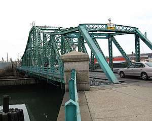 The Grand Street Bridge over the Newtown Creek, as seen from Brooklyn side | |
| Owner | City of New York |
|---|---|
| Maintained by | NYCDOT |
| Length |
4.4 mi[1] (7.1 km) 1.7 mi (2.74 km) as Grand Street 2.9 mi (4.67 km) as Grand Avenue additional 3.8 mi (6.12 km) as Broadway[2] |
| Location | Brooklyn, Queens |
| Postal code | 11211, 11206, 11378, 11373 |
| Nearest metro station |
Grand Street Grand Avenue–Newtown |
| West end | Rodney Street in Williamsburg |
| Major junctions |
|
| East end |
|
Grand Street and Grand Avenue are the respective names of a street which runs through the boroughs of Brooklyn and Queens, New York City, United States. Originating in Williamsburg, Brooklyn, Grand Street runs roughly northeast until crossing Newtown Creek into Queens, whereupon Grand Street becomes Grand Avenue, continuing through Maspeth where it is a main shopping street, until reaching its northern end at Queens Boulevard in Elmhurst.
The thoroughfare continues north and west beyond Queens Boulevard as Broadway until terminating on the bank of the East River in western Queens (in Astoria/Long Island City).
Transportation
Grand Avenue and Grand Street is served by the Q54, Q58 and Q59 buses, all operated by MTA New York City Bus. Broadway is served by the Q53 SBS and Q104 buses, both operated by MTA Bus. The Grand Street (L train) subway station serves the corner of Grand Street and Bushwick Avenue, while the Grand Avenue – Newtown (E, M, and R trains) subway station is located at Grand Avenue and Queens Boulevard. The IND Queens Boulevard Line continues from the Grand Avenue-Newtown station up Broadway until the Steinway Street station. The Broadway (N and W trains) subway station is located at Broadway and 31st Street.
History
When Williamsburg was an independent town (and, later, city), Grand Street was its first main east-west commercial street which acted as a dividing line between the Northside of town and the Southside of town. Street numbering originated here with North 1st Street, North 2nd Street (now Metropolitan Avenue) and so on running parallel to Grand to the north and South 1st Street, South 2nd Street and so on progressing to the south. Its initial segments from the East River were first named Washington Street and then Dunham Street.[3] It was extended to the southeast to Roebling Street in 1812 and to the then village line between Rodney and Keap Streets in 1830.[3] Soon after, the street was extended to Union Avenue in the new third ward of Williamsburg and bent on an angle to the east in order to pass through the property of several prominent land owners.[3] Grand Street was opened from Bushwick Avenue to Metropolitan Avenue in 1858.
In the 19th century, before the construction of the Williamsburg Bridge, the Grand Street Ferry connected Grand Street, Brooklyn to Grand Street, Manhattan. The Grand Street Line was a streetcar line along the road. Two Long Island Rail Road stations existed along the street in both boroughs. Grand Street (LIRR Evergreen station) along the Evergreen Branch near Willamsburg from 1868 to 1885, and Grand Street (LIRR Main Line station), a station in Elmhurst along Main Line that also served the Rockaway Beach Branch from 1913 to 1925.
At some point between the construction of the Williamsburg Bridge and 1913 (it appears on a 1913 map of Brooklyn[4]), Grand Street was connected to the bridge plaza from the elbow bend near Union Avenue by the Grand Street Extension (now named Borinquen Place) and this became the main flow for car traffic. In 1950, Grand Street was severed by the BQE between Marcy Avenue and Rodney Street.
Grand Street Bridge
| Grand Street Bridge | |||||||||||||||||||||||||||||||
|---|---|---|---|---|---|---|---|---|---|---|---|---|---|---|---|---|---|---|---|---|---|---|---|---|---|---|---|---|---|---|---|
| Coordinates | 40°42′59″N 73°55′22″W / 40.716495°N 73.922748°WCoordinates: 40°42′59″N 73°55′22″W / 40.716495°N 73.922748°W | ||||||||||||||||||||||||||||||
| Carries | Grand Street and Grand Avenue | ||||||||||||||||||||||||||||||
| Crosses | Newtown Creek | ||||||||||||||||||||||||||||||
| Locale | Brooklyn and Queens, New York City | ||||||||||||||||||||||||||||||
| Maintained by | New York City Department of Transportation | ||||||||||||||||||||||||||||||
| Followed by | |||||||||||||||||||||||||||||||
| |||||||||||||||||||||||||||||||
Grand Street and Grand Avenue are connected via a swing bridge over Newtown Creek, known as the Grand Street Bridge[6] Construction began in August 1900 [8] and was planned to be completed in October 1901, but the bridge did not open until December 1902.[9] A later report found the delay was caused by the contractor hired to build the bridge being incompetent, forcing the City to finish the project.[9] The current bridge is the third on the site. The first two, both made of wood, were built in 1875 and 1890.[10]
In popular culture
The street is referenced in songs and books from many local artists, including Tom Waits and Kathleen Brennan ("I Don't Wanna Grow Up", popularized by the Ramones) and Matt & Kim (the title of their album Grand, as well as in the lyrics of their songs "Cameras" and "Daylight").
References
- ↑ Google (January 9, 2017). "Grand Street and Grand Avenue" (Map). Google Maps. Google. Retrieved January 9, 2017.
- ↑ Google (January 10, 2017). "Broadway" (Map). Google Maps. Google. Retrieved January 10, 2017.
- 1 2 3 Brooklyn Genealogy. http://www.bklyn-genealogy-info.com/Town/Eastern/G.html
- ↑ Brooklyn Genealogy. http://www.bklyn-genealogy-info.com/Map/Maps.Main.html
- ↑ "New York City Bridge Traffic Volumes" (PDF). New York City Department of Transportation. 2016. p. 9. Retrieved March 16, 2018.
- 1 2 "Movable Bridges over Newtown Creek and its Tributaries". NYC DOT Bridges. New York City Dept. of Transportation. Retrieved October 9, 2013.
- ↑ New York City Bridge Traffic Volumes 2010 (PDF). New York City Dept. of Transportation. 2012. p. 9.
- ↑ "Work Begun on New Bridge". Brooklyn Daily Eagle. August 27, 1900. Archived from the original on October 29, 2013. Retrieved October 24, 2013.
- 1 2 City Club of New York (1903). Mayor Low's Administration in New York. City Club of New York. p. 133.
- ↑ Waxman, Mitch (July 15, 2013). "Peculiar Erudition". Newtown Pentacle. Retrieved October 9, 2013.
External Links
Route map: