Macombs Dam Bridge
| Macombs Dam Bridge | |
|---|---|
 View from the south showing the swing span at left and the camelback span at right | |
| Coordinates | 40°49′41″N 73°56′02″W / 40.82806°N 73.93389°WCoordinates: 40°49′41″N 73°56′02″W / 40.82806°N 73.93389°W |
| Carries | Four lanes of Jerome Avenue |
| Crosses | Harlem River and Metro-North |
| Locale |
Manhattan and the Bronx, New York City |
| Owner | City of New York |
| Maintained by | NYCDOT[1] |
| Preceded by | High Bridge |
| Followed by | 145th Street Bridge |
| Characteristics | |
| Design | swing[1] and camelback bridge |
| Total length | 2,540 feet (774.19 m)[1] |
| Longest span | 408 feet (124.36 m)[1] |
| History | |
| Construction cost | $181 million[1] (rehabilitation) |
| Opened | May 1, 1895[1] |
| Statistics | |
| Daily traffic | 38,183 (2016)[2] |
The Macombs Dam Bridge (/məˈkuːmz/ mə-KOOMZ) spans the Harlem River in New York City, connecting the boroughs of Manhattan and the Bronx near Yankee Stadium. It is the third-oldest bridge in New York City[3] and, along with the 155th Street Viaduct, was designated a New York City Landmark in January 1992. The bridge is operated and maintained by the New York City Department of Transportation (NYCDOT).
History and description
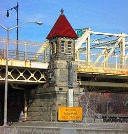
The bridge is located 3.2 miles (5.1 km) from the mouth of the Harlem River. It consists of a swing bridge over the Harlem River decorated with four finials and with stone end piers with shelter houses, and a camelback span over the railroad tracks on the Bronx side. The main swing span is 408 feet (124 m) long and provides two shipping channels with 150 feet (46 m) of horizontal clearance. When closed the bridge provides 25 feet (7.6 m) of vertical clearance. The bridge's total length is 2,540 feet (770 m).
The current bridge is the most recent of several bridges in the area, the first of which – along with the since-demolished lock-and-dam system – opened in 1814. The wooden Central Bridge followed in 1861, to be replaced by the current bridge, which was also called the Central Bridge;[3] a plaque bearing this name still can be seen on the swing span. However the name never stuck. The old name of Macombs Dam Bridge remained in popular use, and the was officially renamed with its original moniker in 1902.[4][5]
Construction began in 1890 and was completed in 1895[3] at a total cost of $1.3 million. The bridge, which was designed by consulting engineer Alfred Pancoast Boller,[6] opened on May 1, 1895.[5] The New York City Department of Transportation, which operates and maintains the bridge, began a $145 million renovation in 1999 and completed it in 2004.[7]
It has four lanes for vehicular traffic and a sidewalk on each side for pedestrians.[4][5]
At the western end of the bridge is a long steel viaduct[3] leading to the intersection of 155th Street and Adam Clayton Powell, Jr. Boulevard (Seventh Avenue), both of which end at the bridge. At the eastern end, a steel approach road leads to Jerome Avenue, which extends north into the Bronx and Westchester County.
Immediately to the north of the bridge was the Putnam Bridge over which the now-demolished 9th Avenue El reached the Bronx and the IRT Jerome Avenue Line. The bridge was demolished in 1960 due to this section of the 9th Avenue El's ceasing operation in 1958.
For 2011, the New York City Department of Transportation reported an average daily traffic volume in both directions of 44,311, with a peak of 55,609 in 1957.[8]
Public transportation
The Macombs Dam Bridge carries the Bx6 and Bx6 SBS bus routes operated by MTA New York City Transit. The route's average weekday ridership is 21,973.[9]
See also
References
Notes
- 1 2 3 4 5 6 Michael R. Bloomberg, City of New York (January 23, 2004). "New York City's Harlem River Bridges: The Reauthorization of the Transportation Equity Act for the 21st Century" (PDF). Retrieved December 2, 2017.
- ↑ "New York City Bridge Traffic Volumes" (PDF). New York City Department of Transportation. 2016. p. 9. Retrieved March 16, 2018.
- 1 2 3 4 New York City Landmarks Preservation Commission; Dolkart, Andrew S.; Postal, Matthew A. (2009), Postal, Matthew A., ed., Guide to New York City Landmarks (4th ed.), New York: John Wiley & Sons, ISBN 978-0-470-28963-1 , pp. 204-205
- 1 2 "Macomb's Dam Bridge". bridgesnyc. 2010. Retrieved 2014-01-17.
- 1 2 3 "N.Y.C. Department of Transportation - Infrastructure - Harlem River Bridges". nyc.gov. New York City Department of Transportation. Retrieved 12 January 2016.
- ↑ White, Norval; Willensky, Elliot & Leadon, Fran (2010), AIA Guide to New York City (5th ed.), New York: Oxford University Press, ISBN 9780195383867 , p. 547
- ↑ "Macombs Dam Bridge - Historic Overview". nycroads.com. NYCRoads.com. Retrieved 7 March 2018.
- ↑ New York City Department of Transportation (March 2010). "2008 New York City Bridge Traffic Volumes" (PDF). p. 74. Retrieved 2010-06-27.
- ↑ "Average Weekday NYC Transit Bus Ridership". MTA New York City Transit. 2012. Retrieved 2012-07-04.
External links
| Wikimedia Commons has media related to Macombs Dam Bridge. |
- Official website
- Historic American Engineering Record (HAER) No. NY-269, "Macombs Dam Bridge, Spanning Harlem River Between 155th Street Viaduct, Jerome Avenue, & East 162nd Street, Bronx, Bronx County, NY", 80 photos, 27 data pages, 11 photo caption pages
- Macombs Dam Bridge at Structurae
- NYC roads.com
- Modjeski Construction
- Picture of Putnam Bridge, the now-demolished el bridge that was north of Macombs Dam Bridge
- Side view of above bridge
- Aerial view of Polo Grounds, Yankee Stadium, Putnam Bridge and Macombs Dam Bridge
Crossings of the Harlem River | ||||
|---|---|---|---|---|
| ||||