Mill Basin, Brooklyn
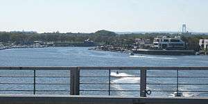
Mill Basin is a peninsular residential neighborhood in New York City in the southern portion of the borough of Brooklyn lying along Jamaica Bay and bounded to the north by Avenue U, and to the east, south, and west by the Mill Basin/Mill Island Inlet. The area is part of Brooklyn Community Board 18.[1]
Mill Basin was originally an island named Mill Island, which was located in Jamaica Bay. It was first settled in the 17th century and a mill was built on the island. Mill Island was developed as an industrial district starting in the 1890s and continued through the 1960s, though a lack of railroad connections hindered the area's further growth. Mill Basin was then developed as a residential area in the 1950s, as was much of southeast Brooklyn. However, some of the former industrial buildings remain.
Mill Basin contains some of the most opulent houses in New York City, as well as the Kings Plaza shopping mall. The modern neighborhood also contains a subsection called Old Mill Basin, located on mainland Brooklyn. The waterway surrounding the neighborhood to the east, south, and west is also called Mill Basin.
Geography
Originally, Mill Basin was an island in Jamaica Bay off the coast of Canarsie, called "Mill Island". Most of the island was sea-level meadows, but a very small portion of the island was arable uplands.[2]:10–11 The original geography of the area was vastly different from the modern geography.[2]:37 A bulkhead was built along the shore in the late 1890s. It was later connected to the uplands of nearby Bergen Beach. This created a continuous embankment between Mill Basin and Paerdegat Basin, which was later used for the construction of Belt Parkway.[3]:77 Most of the earliest filling operations along Mill Island were conducted by private entities, although the city government later took over filling operations.[2]:73
Some parts of Mill Basin remained a wetland until the late 20th century.[4][5][6] A stream formerly ran where Avenue U is today, dividing Mill Island from the mainland.[4] Maps show that Mill Island was connected to the mainland by 1926.[2]:40–41 However, modern city maps still allude to "Mill Island". The New York Times described the neighborhood as a "mitten-shaped peninsula" enclosed to the south, west, and east by the eponymous waterway.[7]
History
Early settlement
The local Lenape Native Americans originally inhabited the area. They referred to the surrounding area, including Mill and Barren Islands, as "Equendito" or "Equindito", a name that probably means "Broken Lands".[8]:257 In 1624, the Dutch Republic incorporated much of the current New York City area into the colony of New Netherland.[2]:4 In 1636, as the Dutch was expanding outward from present-day Manhattan, Dutch settlers founded the town of Achtervelt (later Amersfoort, then Flatlands) and purchased 15,000 acres (6,100 ha) around Jamaica Bay. Amersfoort was centered around the present-day intersection of Flatbush Avenue and Flatlands Avenue.[2]:9 Canarsie Indian leaders had signed three land agreements with Dutch settlers between 1636 and 1667, handing ownership of much of their historic land, including Mill Island, to the Dutch.[2]:7 Mill Island, as well as the nearby Barren Island, was sold to John Tilton Jr. and Samuel Spicer in 1664.[9][6] At one point in the 1660s or 1670s, a settler named Elbert Elbertse leased Mill Island, along with Bergen and Barren Islands.[2]:11
The land was owned from 1675 by Jans Martense Schenck,[2]:12[4] who built a house on the land.[10][2]:22 It is believed to be one of the oldest houses in New York City.[11] Schenck also built a pier so he could load and unload cargo to or from the Netherlands.[10] A tide mill had been built on the land by that time,[5][6] but the exact date of the mill's construction is not known; sources give varying dates between 1660 and 1675.[2]:12 It is said that one of Schenck's relatives, a ship captain named Hendrick, formed an alliance with the pirate William Kidd and allowed Kidd to bury treasure on Mill Island.[4]
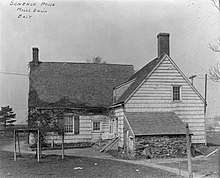
When Schenck died in 1689, his son Martin received ownership of the estate.[12][2]:14 The mill was later inherited by Nicholas Schenck.[2]:14 In 1784, the property was sold to Joris Martense of Flatbush. Martense also received "66 acres [27 ha] of uplands, 6 acres [2.4 ha] of woodlands, and a parcel of salt-meadows" in the transaction, as was noted in a 1909 book.[11]:19 By 1794, John Schenck was renting the property from Joris's widow. At the time, the mill was called "the mill of Martensen".[2]:14
The property, which included the mill, farm, and house, was later conveyed to Susan Caton, the daughter of Joris Martense.[11]:20 Caton named Robert L. Crooke as the trustee for Caton's daughter, Margaret Crooke, who was married to General Philip S. Crooke.[11]:20 In 1818, Margaret Crooke inherited the land. After this conveyance, the mill was called "Crooke's Mill".[2]:14 General Crooke was the trustee for the Crooke children, and upon Margaret's death, had the power to pass the property down to their children.[11]:20 In 1870, after Margaret died, General Crooke conveyed the property to Robert, who gave the property back in 1873. For the next thirty years, there would be a dozen more land conveyances, and by 1906, Robert Crooke ended up owning the property again.[11]:21
The name "Mill Island" is believed to have been used starting in the late 19th century. Before then, settlers called it "the mill" because of the gristmill there.[2]:12
Industrial development
As late as 1890, the area retained its rural character, and the only structures on the island were a house and "three stable" buildings.[2]:37 Until the early twentieth century, the chief resources were the abundant crabs, oysters, and clams in Jamaica Bay.[6] However, in 1890, Robert Crooke built a lead-smelting plant on Mill Island.[8] The Crooke Smelting Company was bought out by the National Lead Company, and Robert sold the remainder of the land to the firm of McNulty and Fitzgerald, which erected bulkheads and filled in the marshes.[2]:37[6] By 1906, Mill Island reportedly received 4,000 tons of ore annually. The island's factories had a combined annual output of 3,800 tons of metals whose aggregate value was $1,250,000. Boats delivered and received shipments using nearby waterways.[2]:37
Robert Crook sold the former mill to Florence C. Smith on January 12, 1906. The next day, Smith deeded it to the real estate company Flatbush East, who transferred the land's ownership to Flatbush Improvement Company on December 31 of the same year.[11]:21 The Flatbush Improvement Company brought marshland and engaged the firm of Atlantic, Gulf and Pacific to dredge creeks and fill in meadows.[2]:37 After the filling project was completed, the parcel had an area of 332 acres (1.34 km2) and was fit for industrial development.[3]:68 As compensation, Atlantic, Gulf and Pacific acquired ownership of the eastern portion of Mill Island,[2]:37 which comprised about 800 acres (320 ha) of land. Atlantic, Gulf and Pacific built factories and worker housing on its half of the island, and in 1916, began laying sidewalks and utilities. The expanded island attracted companies such as National Lead, Gulf Refining, and other leading firms engaged in heavy industry, which were operating plants along the Mill Island shoreline.[13] Additionally, construction of an extension of Flatbush Avenue to the Rockaway Inlet started in 1913.[2]:37
In 1910, developers began dredging ports within Jamaica Bay in an effort to develop a seaport district there.[14] Work on dredging a 500-foot-wide (150 m), 18-foot-deep (5.5 m) main ship channel started in 1912 and was completed the next year, but lawsuits delayed progress until the 1920s. The channel ran along the western and northern shores of Jamaica Bay[2]:73 The first improvements to Mill Island itself started in 1915, when a wooden pier was installed along Flatbush Avenue.[15] In 1916, 12,000 feet (3,700 m) of shoreline along Mill Island was incorporated into the proposed port. At the time, a 2-mile-long (3.2 km), 50-foot-wide (15 m) channel was to be excavated within Mill Basin, the waterway.[16] This new channel would allow a proposed extension of the Flatbush Avenue Streetcar from Avenue N to the Mill Basin shoreline.[13] A contract to dredge the Mill Basin channel, along the southern and western sides of the island, was awarded in 1917.[15] Mill Basin would eventually be 1,000 feet (300 m) wide and 15 feet (4.6 m) deep.[2]:73 Work on the main ship channel restarted in 1923. After the entire main channel was dredged to 500 feet wide by 18 feet deep, it was re-dredged to 1,000 feet wide by 30 feet (9.1 m) deep. This project was completed by the late 1930s, eliminating many small islands in the bay and causing the expansion of another island, Canarsie Pol.[2]:73 The eastern branch of Mill Basin had been created by the 1930s.[2]:73
In 1918, the city allowed several large piers to be constructed within the bay, though only one was built.[2]:72 The pier, which was built in order to receive landfill for the other proposed piers, stretched 1 mile (1.6 km) northeast of Barren Island, south of Mill Island, and was 700 feet (210 m) wide.[2]:77–79 A total of six such piers were planned for this area.[17] In June of that year, a 447-foot-long (136 m) municipally owned pier was opened at Mill Basin. At the time, there were proposals to fill in 8,000 acres (3,200 ha) between Mill and Barren Islands so 14 more piers could be built.[18] By 1919, Atlantic, Gulf and Pacific was building three large dry docks on Mill Island. It was also constructing seven barges for the United States Navy. The fill for the docks came from as far away as Europe. As of that year, Mill Island was the site of at least six manufacturing and commercial concerns.[2]:37 One observer attributed the presence of several of these factories to the proposed improvements at Jamaica Bay.[19] A contract for building concrete piers was awarded in 1921 and completed the next year.[15] In 1925, the Flatbush Avenue extension to Rockaway Inlet opened,[20] providing an additional 2,700 feet (820 m) of dock facilities and a strip of land for a road across the marshes.[2]:37 However, construction of the actual docks did not start until 1927.[21] During the late 1920s and 1930s, the New York City Department of Docks rented the docks to a number of small industrial firms.[2]:38
The development of the proposed docklands at Jamaica Bay spurred large increases in property values in Mill Basin, since the docklands was expected to gain a connection to the Long Island Rail Road.[15] Planners wanted to create a spur of the Bay Ridge Branch south to Flatlands, with two branches to Canarsie and Mill Basin.[2]:71 A connection to Staten Island would be built via the planned Staten Island Tunnel, which would in turn allow freight to be delivered and shipped to the rest of the continental United States.[17] The Port Authority of New York and New Jersey offered to build the new railroad link for $2 million and lease it to the city.[22] However, Mill Basin's further development was hindered when plans for rail service to the rest of Brooklyn went unrealized.[2]:38[5] Industrial activity continued through the 1960s.[5]
In 1927, United States Secretary of Commerce Herbert Hoover's "Fact-Finding Committee on Suitable Airport Facilities for the New York Metropolitan District" suggested Southeast Brooklyn as a possible site for a new municipal airport in New York City.[23] The New York City Chamber of Commerce approved the 800-acre (320 ha) site in September of that year.[24] Originally, real-estate developers suggested that 300 acres (120 ha) in Mill Basin could be used for the new airport, which would allow the airfield to open before the end of 1928.[25] Ultimately, New York City's aeronautical engineer Clarence Chamberlin selected nearby Barren Island as the site for the new airport, which later became Floyd Bennett Field.[26][27]
Belt Parkway was built through the neighborhood in the 1930s, and it opened in 1940.[28] A drawbridge over Mill Basin was approved in 1939[29] and completed the next year (see § Mill Basin Drawbridge).[30]
Residential development
Old Mill Basin was developed north of the Mill Basin peninsula from the 1920s to the 1940s.[4] However, the 1939 WPA Guide to New York City mentions that the area comprising present-day Mill Basin and Bergen Beach was the residence of "pathetic communities of squatters, who live in makeshift houses, and eke out a living by fishing and scouring the near-by city dumps for odd necessities". At the time, the southern shore was still marshland.[31] Residential development on the peninsula began after World War II, when Atlantic, Gulf and Pacific sold a large plot of land to the firm of Flatbush Park Homes. The land was bounded to the north by Avenue U, to the east by East 68th Street and East Mill Basin/Mill Island, to the south by Basset Avenue, and to the west by Strickland Avenue and Mill Avenue.[5] Over 100 brick bungalows were built in the late 1940s and early 1950s, many of which were later replaced by large, custom-built, detached one-family houses on lots measuring 50 by 100 feet (15 by 30 m). The Crooke-Schenck House, which stood at East 63rd Street, was dismantled in 1952 and later reassembled as a museum exhibit at the Brooklyn Museum.[4] Starting in the 1950s, a series of suburban waterfront communities were being rapidly developed in Southeast Brooklyn, including in present-day Bergen Beach, Canarsie, and Mill Basin.[32] In 1956, builders announced the construction of 1,500 homes on the Mill Basin peninsula.[33] However, as late as the 1960s, parts of the area were still a swamp.[4][5][6]
During the 1950s, private developers laid their own streets while constructing houses in the neighborhood, resulting in the creation of a patchwork of private roads.[34] Some of these streets were poorly maintained: a newspaper article from 1954 described houses that flooded after heavy rains because there were no sewage pipes.[35] In 1963, the city government asked the developers to fix these streets, which were already breaking down. The city argued that these streets would remain private roads until the streets were upgraded to city standards, but the developers took the opposite argument, saying that the streets were not up to city standards because they were private roads.[36] After a controversy over the paving of the streets, the city ultimately dropped their requests for builders to pave these streets, instead forwarding the matter to the New York City Department of Highways. The New York City Department of Buildings agreed not to grant any certificates of occupancy to any new building unless the street in front of it was paved.[37] In 1964, a federal judge signed an order that transferred these private streets to city ownership, allowing the city to pave these streets.[38]
The area gained residential popularity by the end of the 1960s.[39] By 1963, a new 69th Precinct building for the New York City Police Department, as well as the South Shore High School in Canarsie, were being constructed to accommodate the growing population.[32] Due to a large number of new residents moving in, temporary classrooms were built on the playground of P.S. 236.[4] A training school for sailors was also constructed in Mill Basin.[40] The neighborhood had some of the most expensive houses in Brooklyn by 1972.[41]
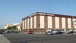
Several controversies arose during the development of Mill Basin as a residential neighborhood. In 1954, the city "indefinitely" postponed the construction of a garbage incinerator that had been planned for the area.[42] Another controversy in 1966 surrounded a "boatel", or motel with boating docks, that had been planned for the site of a marsh south of the Mill Basin waterway.[43] The boatel site, which was located at the intersection of Belt Parkway and Flatbush Avenue, was supposed to contain a shopping mall with docks for up to 300 boats.[44] Residents continued to oppose plans for the shopping center since it would have been located on a wildlife sanctuary.[45] Plans for the shopping mall were scrapped the next year after the city denied a rezoning plan for Mill Basin that would have allowed the shopping mall's construction.[46] Another shopping mall, Kings Plaza, had been dedicated in 1968 at a site further north, on Avenue U.[47]
Community
Mill Basin is characterized as a suburban community with a nearly-360-degree shoreline. It is adjoined by a waterway of the same name to the south and west. As a result of the large shoreline, many residents own boats.[7]
The neighborhood has evolved to include some of New York City's most opulent houses.[5][6] Most of the housing stock was developed starting in the late 20th century, and many waterfront houses include docks, water views, or high ceilings. Prices of houses often range in the millions.[48] As of 2017, the price of an unrenovated house on a 40-by-100-foot (12 by 30 m) lot along a main street starts at about $850,000. Housing prices rose based on the width of the lot, extent of renovations, and proximity to the water: the cheapest waterfront house is $1.6 million.[7] A few houses also had elevators inside them, and several residences have features such as six-car garages and all-glass facades.[4] One of the residences, a compound with a 14,000-square-foot (1,300 m2) main building and a 7,800-square-foot (720 m2) guesthouse, was put for sale at $30 million in 2013. At the time, it was the most expensive residence ever listed for sale in Brooklyn.[7]
In Georgetown, north of Mill Basin, there are two-family brick townhouses with overhanging balconies and awnings.[5] Old Mill Basin, to the northeast, mostly has detached frame houses. It is defined as the portion of the neighborhood north of Avenue U.[7] In Mill Island, the peninsular part of Mill Basin, houses are more expensive than in the rest of the neighborhood; by contrast, the cheapest houses are on the northwest corner.[48] The former Mill Island and Old Mill Basin are divided by Avenue U, at the Mill Basin waterway's innermost reaches.[7]
Some lead factories, built in the 20th century by Dutch businessmen, still remain standing, but many are derelict. Commercial activities, mainly family-owned shops and restaurants, are located mainly along Strickland Avenue and Avenue U.[48] The Kings Plaza shopping mall, located on a 23-acre (9.3 ha) plot at Avenue U and Flatbush Avenue,[47] is the largest indoor shopping center in Brooklyn.[49] The neighborhood also contains Mill Plaza Mall, a strip mall at the northwest corner of Mill and Strickland Avenues.[7]
Demographics
From the 1950s through the 1980s, the area was mainly Italian, but the predominant communities today are Russians and Israelis.[6] By the end of the 20th century, the vast majority of Mill Basin residents were white, as were most residents of adjacent neighborhoods such as Bergen Beach and Marine Park. The 1990 United States Census counted 10 African-Americans living in Mill Basin; by the 2000 United States Census, there were 26 black residents.[50] However, by 2011, the number of black residents in Southeast Brooklyn had risen 241%, the steepest such increase of any area in the city. As of that year, the African American population in these neighborhoods represented 10.9% of the total population.[51]
Based on data from the 2010 United States Census, the combined population of Georgetown, Marine Park, Bergen Beach, and Mill Basin was 45,231, an increase of 2,291 (5.3%) from the 42,940 counted in 2000. Covering an area of 1,662.88 acres (672.94 ha), the neighborhood had a population density of 27.2 inhabitants per acre (17,400/sq mi; 6,700/km2).[52]
As of the 2010 Census, the racial makeup of Southeast Brooklyn was 73.8% (33,399) White, 10.9% (4,952) African American, 0.1% (47) Native American, 5.6% (2,521) Asian, 0.0% (7) Pacific Islander, 0.3% (144) from other races, and 1.3% (578) from two or more races. Hispanic or Latino of any race were 7.9% (3,583) of the population.[53]
Police and crime
Mill Basin is patrolled by the NYPD's 63rd Precinct, located at 1844 Brooklyn Avenue in Flatlands. The precinct also covers Bergen Beach, Marine Park, and part of Flatlands.[54] As of 2017, the 63rd Precinct reported 3 murders (3 in 2001), 12 rapes (17 in 2001), 114 robberies (265 in 2001), 146 felonious assaults (161 in 2001), 97 burglaries (339 in 2001), 516 grand larcenies (536 in 2001), and 65 grand larceny auto (497 in 2001).[55]
Recreation
There are several parks in Mill Basin.[4] The only park on the peninsula proper is Lindower Park, a 6.7-acre (2.7 ha) park at the southwest corner of Mill and Strickland Avenues, is named after Alex Lindower, a lawyer and community activist who lived in Mill Basin. The city bought the land in 1959 and made it into a public park in 1963, the year before Lindower died. It contains baseball fields, basketball and handball courts, and a children's playground.[56]
There are two smaller parks in Old Mill Basin. The James Marshall Power Playground, located at Avenue N and Utica Avenue, is a frequent gathering point for softball teams.[4] The Monsignor Crawford Athletic Field, located on Avenue U between East 58th and East 60th Streets, contains two baseball fields. It is named after Monsignor Thomas J. Crawford, the first pastor of the Mary Queen of Heaven Church, located four blocks north of the ballfields.[57]
The bowler Lou Seda purchased the Gil Hodges Lanes, a bowling alley in Mill Basin, in 2009. It was fully refurbished into Strike 10 Lanes, a new bowling alley.[58] As of 2012 it was one of six bowling alleys in Brooklyn, although one alley was slated to close in 2014.[59]
Education
The New York City Department of Education operates several schools in the neighborhood. They include P.S. 312,[60] P.S. 236,[61] and P.S. 203,[62] all of which have historically ranked among the top public schools in the city.[4][7]
Brooklyn Public Library operates the Mill Basin Library at 2385 Ralph Avenue, near Avenue N. The Mill Basin Library first opened in 1940, and it has been located in its current building since 1975.[63]
Transportation
Mill Basin is served by the B3, B41, B47, B100, and BM1 bus routes, operated by MTA Regional Bus Operations.[64] There are no New York City Subway stations in the neighborhood; the closest stop is Kings Highway in Midwood, along the B and Q trains.[7] BM1 express bus service to Manhattan started in 1973,[65] mainly as a result of the area's isolation from the subway.[66]
Mill Basin Bridge
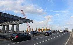
The original Mill Basin Bridge is a double leaf trunnion bascule bridge supporting the Belt Parkway over Mill Basin. Each leaf formerly carried six lanes of traffic, three in each direction, but as of 2017, only the eastbound lanes use the drawbridge.[67] There was a sidewalk on each side of the leaf; the eastern or downstream one, the only one still extant, is part of the Shore Parkway Greenway.[68] Construction of the span was approved in 1939,[29] and the bridge was opened in 1940. It is the only drawbridge on the Belt Parkway.[30] The New York City Department of Transportation renovated the Belt Parkway Bridge over Mill Basin in late 2006 because of severe deterioration, but began planning for a replacement span.[69]
In 2013, the city proposed a 60-foot (18 m)-high fixed bridge to replace the aging span. The new bridge will also feature shoulders and wider lanes, which the drawbridge was not built with.[70] The new bridge started construction in 2015, with an expected completion date of 2021, four years after its original completion date of 2017.[71] The westbound lanes were shifted to the newer bridge in August 2017.[67]
References
- ↑ Brooklyn Community Boards, New York City. Accessed December 31, 2007.
- 1 2 3 4 5 6 7 8 9 10 11 12 13 14 15 16 17 18 19 20 21 22 23 24 25 26 27 28 29 30 31 32 33 Black, Frederick R. (1981). "JAMAICA BAY: A HISTORY" (PDF). United States Department of the Interior, National Park Service.
- 1 2 Bailey, Rosalie Fellows (1938). Pre-revolutionary Dutch houses and families in Northern New Jersey and Southern New York. Retrieved January 16, 2018 – via HathiTrust.
- 1 2 3 4 5 6 7 8 9 10 11 12 Radomsky, Rosalie R. (March 17, 1991). "If You're Thinking of Living in: Mill Basin". The New York Times. Retrieved January 18, 2018.
- 1 2 3 4 5 6 7 8 Hughes, C. J. (May 1, 2009). "Mill's Long Gone, but the Basin's Still Full". The New York Times. Retrieved November 1, 2015.
- 1 2 3 4 5 6 7 8 Sheftell, Jason (May 13, 2008). "Brooklyn neighborhood has Park Avenue beat". NY Daily News. Retrieved November 1, 2015.
- 1 2 3 4 5 6 7 8 9 Lasky, Julie (June 2, 2017). "Mill Basin, Brooklyn: House-Proud, but Not Too Accessible". The New York Times. Retrieved January 18, 2018.
- 1 2 Seitz, Sharon; Miller, Stuart (2011). The Other Islands of New York City: A History and Guide (Third Edition). Countryman Press. ISBN 978-1-58157-886-7.
- ↑ Ross, Peter (1902). A History of Long Island, Vol. 1. Jazzybee Verlag. p. 37. ISBN 9783849679248.
- 1 2 Eberlein, H.D. (1928). Manor Houses and Historic Homes of Long Island and Staten Island. Empire State historical publications series. J. B. Lippincott Company. p. 257. Retrieved January 20, 2018.
- 1 2 3 4 5 6 7 Ditmas, C.A. (1909). Historic Homesteads of Kings County ... Genealogy & local history. The Compiler. Retrieved January 20, 2018.
- ↑ "Brooklyn Museum". Brooklyn Museum. July 13, 2007. Retrieved January 20, 2018.
- 1 2 "MILL BASIN DEVELOPMENT.; Great Tract Available for Factory and Home Improvement" (PDF). The New York Times. February 20, 1916. Retrieved January 21, 2018.
- ↑ "Marine Park Highlights". New York City Department of Parks & Recreation. June 17, 2003. Retrieved January 6, 2018.
- 1 2 3 4 Wilhelm, Carl (October 2, 1927). "Urge Sale of $200,000,000 of "Made Land" Along New Jamaica Bay Channels as Means to Get City Funds for New Transit Solution". Brooklyn Daily Eagle. p. 77. Retrieved January 22, 2018 – via Brooklyn Public Library; newspapers.com.
- ↑ "DEVELOPMENT OF CITY'S GREAT HARBOR, JAMAICA BAY, TO BE PUSHED BY OWNERS OF LARGE WATERFRONT TRACT" (PDF). The Sun. February 27, 1916. p. 4. Retrieved January 14, 2018 – via Fultonhistory.com.
- 1 2 "JAMAICA BAY WORLD HARBOR; Six 1,000-Foot Piers to Be Installed as a Beginning" (PDF). The New York Times. July 31, 1921. Retrieved January 22, 2018.
- ↑ "MAYOR OPENS CITY'S JAMAICA BAY PIER; Other Officials Take Part In Dedication of Mill Basin as a Port. DANIELS'S LETTER BY AIR Lieut. Kilgore Drops Secretary's Message of Congratulation into the Water, but It Is Rescued" (PDF). The New York Times. June 2, 1918. Retrieved January 21, 2018.
- ↑ "JAMAICA BAY IMPROVEMENT.; Big Manufacturing Firms Establish Plants on Mill Basin" (PDF). The New York Times. April 15, 1917. Retrieved January 21, 2018.
- ↑ "ROCKAWAY FERRY OPENED BY HYLAN; Other City Officials Also Mark Start of Line From Barren Island to Riis Park. ONE FERRYBOAT STRANDED Laden With Women and Children, It Is Held on Sand Bar for Half an Hour" (PDF). The New York Times. October 18, 1925. Retrieved January 7, 2018.
- ↑ "WOULD SPEED WORK ON MILL BASIN PIER; Brooklyn Commerce Chamber Says It Will Open Jamaica Bay to Seagoing Vessels" (PDF). The New York Times. November 27, 1927. Retrieved January 21, 2018.
- ↑ "PROJECTS BIG PORT ABOUT JAMAICA BAY; The Port Authority Offers to Construct $2,000,000 Rail Link to Develop Area. WOULD LEASE IT TO CITY Five-Mile Line Connecting With the Long Island Would Permit 150 Miles of New Piers. Letter Describes Project. PROJECTS BIG PORT ABOUT JAMAICA BAY" (PDF). The New York Times. November 27, 1929. Retrieved January 22, 2018.
- ↑ "Long Island Sites for Airports Recommended". Brooklyn Daily Eagle. December 31, 1927. p. 5. Retrieved December 20, 2017 – via Brooklyn Public Library; newspapers.com.
- ↑ "SITE FOR BROOKLYN AIRPORT; Chamber of Commerce Suggests 800 Acres Off Flatbush Avenue" (PDF). The New York Times. September 21, 1927. Retrieved January 22, 2018.
- ↑ "WANT MILL BASIN FOR AIRPORT SITE; Brooklyn Realty Board Says 300 Acres Are Available for Immediate Use. LAND IS OWNED BY CITY Week on Project Could Be Started With Approval by Board of Estimate" (PDF). The New York Times. January 22, 1928. Retrieved January 21, 2018.
- ↑ "Airport Catches Chamberlin's Eye" (PDF). New York Evening Post. June 3, 1928. p. 2. Retrieved December 15, 2017 – via Fultonhistory.com.
- ↑ "FLOYD BENNETT FIELD GROWS FROM SAND WASTE; Municipal Airport Will Have Facilities for Both Land And Water Planes--Other Fields Rank High Battle With Sand. Two Concrete Runways. To House Services" (PDF). The New York Times. July 20, 1930. ISSN 0362-4331. Retrieved January 8, 2018.
- ↑ "CITY EXTENDS HIGHWAY SYSTEM; New Belt Parkway, Which Starts in Brooklyn and Runs Around Outskirts of That Borough and Queens, Opens Saturday Some Links to Come To Manhattan Bridge A Legal Delay Across Long Island BELT PARKWAY READY TO OPEN" (PDF). The New York Times. June 23, 1940. Retrieved January 22, 2018.
- 1 2 "BROOKLYN SPAN APPROVED; War Department Sanctions Bridge Across Mill Basin" (PDF). The New York Times. April 19, 1939. Retrieved January 22, 2018.
- 1 2 Warerkar, Tanay; Blau, Reuven (September 17, 2013). "Brooklyn's bridges are crumbling!". NY Daily News. Retrieved January 22, 2018.
- ↑ Federal Writers' Project (1939). New York City: Vol 1, New York City Guide. US History Publishers. p. 502. ISBN 978-1-60354-055-1.
- 1 2 "A'SUBURB' GROWS IN MARSHES HERE; Bergen Beach, Mill Basin and Canarsie Sections of Brooklyn Transformed LAND COST IS UP 1,500% Difficulties of Rapid Growth Largely Overcome, but Transit Is a Problem Growth Spectacular Rocker Replaced A 'SUBURB' GROWS IN MARSHES HERE" (PDF). The New York Times. November 28, 1963. ISSN 0362-4331. Retrieved January 17, 2018.
- ↑ "MILL BASIN TRACT TO BE HOME SITE; 1,500-Unit Flatbush Colony to Be Almost Surrounded by Jamaica Bay" (PDF). The New York Times. 1956-06-24. ISSN 0362-4331. Retrieved 2018-01-24.
- ↑ "City In Bid To Take Over Control Of Mill Basin Roads" (PDF). New York & Brooklyn Daily. November 18, 1963. p. 8. Retrieved January 14, 2018 – via Fultonhistory.com.
- ↑ "Venice Has Nothing on Mill Basin After A Downpour". Brooklyn Daily Eagle. August 11, 1954. p. 20. Retrieved January 22, 2018 – via Brooklyn Public Library; newspapers.com.
- ↑ "New Paving Asked in Mill Basin Area" (PDF). The New York Times. September 24, 1963. ISSN 0362-4331. Retrieved January 22, 2018.
- ↑ "MILL BASIN FIGHT DROPPED BY CITY; Department of Highways to Pave Instead of Builders No Objection Offered Agreement Not Binding" (PDF). The New York Times. November 16, 1963. ISSN 0362-4331. Retrieved January 22, 2018.
- ↑ "City Set to Pave Mill Basin Roads". The New York Times. September 2, 1964. ISSN 0362-4331. Retrieved January 22, 2018.
- ↑ "BROOKLYN'S SHORE HAS LUXURY HOMES; Houses Around Mill Basin Follow Styling Trends of Towns In Suburbs TWO COLONIES OPENED Raised Ranch and 2-Story Designs Are in Demand Within City Limits Two New Home Colonies Offer Luxury Features of Suburbs The Brooklyn Waterfront Is Becoming the Scene of Suburban Colonies" (PDF). The New York Times. 1960-07-31. ISSN 0362-4331. Retrieved 2018-01-24.
- ↑ "UNION WILL BUILD SEAMAN'S SCHOOL; Seafarers Project to Rise in Mill Basin Section Aid to Minorities Cited" (PDF). The New York Times. 1963-09-29. ISSN 0362-4331. Retrieved 2018-01-24.
- ↑ "Single - Family Houses Rare in Brooklyn" (PDF). The New York Times. 1972-03-05. ISSN 0362-4331. Retrieved 2018-01-24.
- ↑ "Mill Basin Residents Heartened as Garbage Project Is Postponed". Brooklyn Daily Eagle. May 28, 1954. p. 4. Retrieved December 20, 2017 – via Brooklyn Public Library; newspapers.com.
- ↑ Phillips, McCandlish (April 2, 1966). "Brooklyn Debates Marsh Future: Birds or Boats?; City Proposes a Commercial Center on the Mill Basin 'Who Needs It?' Residents Ask, Preferring Wetland" (PDF). The New York Times. Retrieved January 22, 2018.
- ↑ "LINDSAY ORDERS MARINA INQUIRY; Fraiman to Examine Data on $12-Million Project" (PDF). The New York Times. February 15, 1966. Retrieved January 22, 2018.
- ↑ "Proposed Shopping Center in Mill Basin Marshland Is Opposed by Residents" (PDF). The New York Times. November 23, 1969. Retrieved January 22, 2018.
- ↑ "City Planning Unit Bars Mill Basin Development". The New York Times. September 24, 1970. Retrieved January 22, 2018.
- 1 2 "Shopping Plaza and Marina Are Dedicated in Brooklyn" (PDF). The New York Times. July 9, 1968. Retrieved May 20, 2017.
- 1 2 3 Lefkowitz, Melanie (June 23, 2012). "Mill Basin, Home to Boat Slips in Backyards". WSJ. Retrieved November 1, 2015.
- ↑ William B. Helmreich (October 4, 2016). The Brooklyn Nobody Knows: An Urban Walking Guide. Princeton University Press. pp. 267–268. ISBN 978-0-691-16682-7.
- ↑ Friedman, Andrew (June 3, 2001). "NEIGHBORHOOD REPORT: SOUTHEAST BROOKLYN; Drops of Diversity in a Quiet Area". The New York Times. Retrieved January 15, 2018.
- ↑ Musumeci, Natalie; Durkin, Erin (September 22, 2011). "Black pop. growing in south Bk". NY Daily News. Retrieved January 15, 2018.
- ↑ Table PL-P5 NTA: Total Population and Persons Per Acre - New York City Neighborhood Tabulation Areas*, 2010, Population Division - New York City Department of City Planning, February 2012. Accessed June 16, 2016.
- ↑ Table PL-P3A NTA: Total Population by Mutually Exclusive Race and Hispanic Origin - New York City Neighborhood Tabulation Areas*, 2010, Population Division - New York City Department of City Planning, March 29, 2011. Accessed June 14, 2016.
- ↑ "NYPD – 63rd Precinct". www.nyc.gov. Retrieved October 3, 2016.
- ↑ "CompStat 63rd Precinct" (PDF). New York City Police Department. Retrieved January 19, 2018.
- ↑ "Lindower Park Highlights : NYC Parks". New York City Department of Parks & Recreation. Retrieved January 20, 2018.
- ↑ "Monsignor Crawford Field Highlights : NYC Parks". New York City Department of Parks & Recreation. June 10, 1911. Retrieved January 20, 2018.
- ↑ "Beloved Brooklyn bowling alley faces closure". New York Post. September 10, 2012. Retrieved January 20, 2018.
- ↑ "Bowling In Brooklyn". The Brooklyn Home Reporter. September 12, 2012. Retrieved January 20, 2018.
- ↑ "Welcome to P.S. 312's Website - P.S. 312 Bergen Beach - K312". New York City Department of Education. June 26, 2017. Retrieved January 18, 2018.
- ↑ "Welcome to P.S. 236 - P.S. 236 Mill Basin - K236". New York City Department of Education. November 9, 2017. Retrieved January 18, 2018.
- ↑ "Welcome - P.S. 203 Floyd Bennett School - K203". New York City Department of Education. November 1, 2017. Retrieved January 18, 2018.
- ↑ "History". Brooklyn Public Library. November 7, 2016. Retrieved January 23, 2018.
- ↑ "Brooklyn Bus Map" (PDF). Metropolitan Transportation Authority. November 2017. Retrieved April 24, 2018.
- ↑ "Metropolitan Briefs". The New York Times. 1972-07-09. ISSN 0362-4331. Retrieved 2018-01-24.
- ↑ Burks, Edward C. (1976-09-19). "Express‐Bus Runs Rapidly Expanding". The New York Times. ISSN 0362-4331. Retrieved 2018-01-24.
- 1 2 Cuba, Julianne (2017-09-01). "New Mill Basin Bridge lanes open". Brooklyn Daily. Retrieved 2018-09-25.
- ↑ New York City Department of Transportation: Mill Basin Bridge Archived December 23, 2007, at the Wayback Machine., accessed June 14, 2006
- ↑ Friedman, Neil S. (March 23, 2006). "Is Mill Basin Span A Bridge In Troubled Water?". Canarsie Courier. Retrieved January 18, 2018.
- ↑ Mixson, Colin (March 1, 2013). "Drawbridge up for good". Brooklyn Daily. Retrieved November 1, 2015.
- ↑ Cuba, Julianne (August 26, 2016). "Building bridges: Delayed Belt Parkway spans are back on track". Brooklyn Daily. Retrieved April 2, 2017.
Coordinates: 40°36′36″N 73°54′40″W / 40.61000°N 73.91111°W