Broadway Bridge (Manhattan)
| Broadway Bridge | |
|---|---|
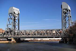 From the west | |
| Coordinates | 40°52′25″N 73°54′40″W / 40.87361°N 73.91111°WCoordinates: 40°52′25″N 73°54′40″W / 40.87361°N 73.91111°W |
| Carries |
6 lanes of 3 tracks of IRT Broadway–Seventh Avenue Line ( |
| Crosses | Harlem River Ship Canal |
| Locale | Manhattan and the Bronx, in New York City |
| Maintained by | New York City Department of Transportation |
| Characteristics | |
| Design | Double-decked Vertical lift bridge |
| Total length | 1,300 feet |
| Longest span | 560 feet |
| Clearance above |
15 feet (lower deck) 20.8 feet (upper deck) |
| Clearance below |
136 feet (41 m) (raised) 24 feet (7.3 m) (lowered) |
| History | |
| Opened | July 1, 1962 |
| Statistics | |
| Daily traffic | 36,027 (2016)[1] |
The Broadway Bridge in New York City crosses the Harlem River Ship Canal between Inwood on Manhattan Island and Marble Hill, also originally part of the island, but separated from it by the ship canal; it is still part of the borough of Manhattan. The bridge is named because it carries Broadway, which is designated as US 9 here. The bridge also carries the IRT Broadway–Seventh Avenue Line (1 train) above the road.
History
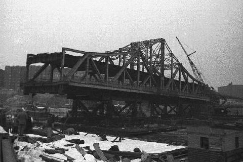
Before the Harlem River was rerouted, the bridge in the area was named Kings Bridge, crossing the river on the border between Marble Hill and the Bronx. The Boston Post Road and Albany Post Road crossed this bridge. A later bridge, opened on January 1, 1895, spanned the canal. A total of three bridges spanned the canal at this location. The 1895 bridge, a steam-powered swinging bridge, accommodated only highway and pedestrian traffic. It was replaced in 1905 by a bridge that could accommodate for the extension of the IRT subway line into the Bronx. The 1905 Broadway Bridge was also a swinging bridge, but a second deck was added to allow for subway traffic on the upper deck, and pedestrian and highway traffic on the lower deck.[2] The 1905 iteration of the Broadway Bridge, that was being replaced by a new double-level structure,[3] was reused to create the University Heights Bridge. In June 1906, the old bridge was floated down the river and placed on a newly constructed center pier. After all the approaches and other construction were completed, the new University Heights Bridge opened to traffic on January 8, 1908.[4]
The present Broadway Bridge (opened on July 1, 1962) has a navigable channel 304 feet (93 m) wide providing 136 feet (41 m) of vertical clearance when the bridge is in the open position. In the down position, the bridge provides 24 feet (7.3 m) of vertical clearance.
Traffic
In 2010, the New York City Department of Transportation, which operates and maintains the bridge, reported an average daily traffic volume in both directions of 37,292. The peak ADT over the Broadway Bridge was 42,555 vehicles in 1990.[5]
Public transportation
The Broadway Bridge carries the New York City Subway's 1 train. As such, when the bridge is open, 1 trains terminate at 215th Street. Shuttle buses provide service to Van Cortlandt Park-242nd Street. Immediately to the north of the bridge along this line is the Marble Hill–225th Street station.[6]
The bridge also carries the Bx7 and Bx20 local bus routes operated by MTA New York City Transit, and the BxM1 express bus route operated by the MTA Bus Company.[7]
See also

References
Notes
- ↑ "New York City Bridge Traffic Volumes" (PDF). New York City Department of Transportation. 2016. p. 9. Retrieved March 16, 2018.
- ↑ "2012 NYC DOT Bridges and Tunnels Annual Condition Report" (PDF). NYC Department of Transportation. Retrieved December 2, 2013.
- ↑ new double-level structure
- ↑ "West 207th Street/University Heights Bridge Over Harlem River". New York City Department of Transportation. Retrieved May 26, 2006.
- ↑ "New York City Bridge Traffic Volumes 2010" (PDF). NYC Department of Transportation. Retrieved December 2, 2013.
- ↑ "Subway Map" (PDF). Metropolitan Transportation Authority. January 18, 2018. Retrieved January 18, 2018.
- ↑ "Bronx Bus Map" (PDF). Metropolitan Transportation Authority. September 2017. Retrieved April 24, 2018.
External links
| Wikimedia Commons has media related to Broadway Bridge (Manhattan). |
- NYCRoads.com: Broadway Bridge Historic Overview
- Broadway Bridge Over Harlem River
- NYC Bridge Wiki:Broadway Bridge Bike and pedestrian access.
- Broadway Bridge at Structurae
- Replacement of the Broadway Bridge Images; 1961 or 1962 (William Palter)
Crossings of the Harlem River | ||||
|---|---|---|---|---|
| ||||