Walloomsac River
The Walloomsac River (/ˈwɑːluːmsæk,
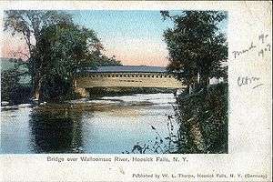
Bridges
The river is crossed by the following roads / railroads via bridges.
Vermont
- Walloomsac Brook

- The Roaring Branch

- North Branch Street - the bridge there is known locally as the Brooklyn Bridge
- Park Street

- Railroad bridge between US Route 7 and Benmont Avenue
- Walloomsac River
- Benmont Avenue
- Hunt Street foot bridge (washed away in flood waters related to Hurricane Irene in August 2011)
- Silk Road via the Silk Covered Bridge
- Murphy Road via two bridges at Paper Mill Village including the Paper Mill Village Covered Bridge
- River Road via the Burt Henry Covered Bridge
New York
- Cottrell Road in two places
- Caretakers Road
- Factory Hill Road

- Railroad bridges in three places
Tributaries
Traveling upstream from the confluence with the Hoosic River, the following tributaries feed the Walloomsac:
- Little White Creek
- Paran Creek
- Walloomsac River (original path through downtown Bennington, name ends at confluence of Roaring Brook and South Stream):
- Roaring Brook
- Barney Brook
- South Stream
- Jewett Brook
- Roaring Branch (of South Stream)
- Roaring Branch of the Walloomsac River (so named on maps from US 7 to VT 9, locally this name continues to Bolles Brook)
- Furnace Brook
- Stratton Brook
- Basin Brook
- Walloomsac Brook (so named on maps from VT 9 to confluence of Bolles Brook and City Stream)
- Bolles Brook
- Bickford Hollow Brook
- Hell Hollow Brook
- City Stream
- Stamford Stream
- Bolles Brook
- Furnace Brook
See also
References
- ↑ Aboriginal place names of New York, By William Martin Beauchamp, page 185
- ↑ U.S. Geological Survey. National Hydrography Dataset high-resolution flowline data. The National Map, accessed October 3, 2011
- 1 2 1898 topographical map of Bennington, VT
- 1 2 1954 topographical map of Bennington, VT
- ↑ Molly Stark Byway, Bennington, History In The Making
External links
- USGS water flow statistics near North Bennington
- NOAA Advanced Hydrologic Prediction Service, Walloomsac River
Coordinates: 42°56′06″N 73°15′57″W / 42.935124°N 73.265762°W