Blooming Grove, New York
| Blooming Grove, New York | |
|---|---|
| Town | |
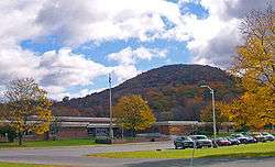 Round Hill from New York State Route 208 in 2006 | |
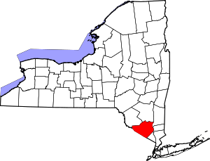
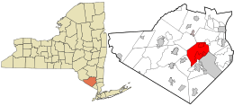 Location in Orange County and the state of New York. | |
 Blooming Grove, New York Location within the state of New York | |
| Coordinates: 41°26′N 74°10′W / 41.433°N 74.167°W | |
| Country | United States |
| State | New York |
| County | Orange |
| Government | |
| • Type | Town Council |
| • Town Supervisor | Robert C. Jeroloman |
| • Town Council |
Members' List
|
| Area[1] | |
| • Total | 35.35 sq mi (91.56 km2) |
| • Land | 34.74 sq mi (89.97 km2) |
| • Water | 0.62 sq mi (1.60 km2) |
| Elevation | 374 ft (114 m) |
| Population (2010) | |
| • Total | 18,028 |
| • Estimate (2016)[2] | 17,676 |
| • Density | 508.87/sq mi (196.47/km2) |
| Time zone | UTC-5 (Eastern (EST)) |
| • Summer (DST) | UTC-4 (EDT) |
| ZIP code | 10914 |
| Area code(s) | 845 |
| FIPS code | 36-07003 |
| GNIS feature ID | 0978739 |
Blooming Grove is a town in Orange County, New York. The population was 18,028 at the 2010 census.
The Town of Blooming Grove is in the central part of the county, located southwest of Newburgh.
History
Vincent Mathews was likely the earliest settler who purchased the Rip Van Dam Patent in 1721, built a grist mill and named his settlement "Mathewsfield."[3] He is the father of David Mathews, a Loyalist who was Mayor of New York during the American Revolutionary War, and Fletcher Mathews, also a Loyalist and alleged abettor to schemes against the newly forming republic.
The Town of Blooming Grove was formed from the Town of Cornwall in 1799. In 1830, the Town of Hamptonburgh was established from part of Blooming Grove. Another part of Blooming Grove was taken to form the Town of Chester in 1845.
The Brotherhood Winery in Washingtonville is the oldest continuously operating winery in the United States, having been established in 1839.
As of July 2006, legislation has been passed in order to incorporate a southern portion of the town into a separate community known as South Blooming Grove. This legislative action has led to the creation of a new community in Orange County for the first time since the late 1970s. On July 14, 2006, the state of New York incorporated the hamlet of South Blooming Grove into a village. This hamlet is now known as the "Village of South Blooming Grove."
Geography
According to the United States Census Bureau, the town has a total area of 35.3 square miles (91 km2), of which, 34.8 square miles (90 km2) of it is land and 0.5 square miles (1.3 km2) of it (1.42%) is water.
Combined New York State Route 17- U.S. Route 6 pass through the south of Blooming Grove.
Demographics
| Historical population | |||
|---|---|---|---|
| Census | Pop. | %± | |
| 1820 | 2,219 | — | |
| 1830 | 2,099 | −5.4% | |
| 1840 | 2,396 | 14.1% | |
| 1850 | 2,184 | −8.8% | |
| 1860 | 2,248 | 2.9% | |
| 1870 | 2,502 | 11.3% | |
| 1880 | 2,444 | −2.3% | |
| 1890 | 2,236 | −8.5% | |
| 1900 | 2,188 | −2.1% | |
| 1910 | 2,110 | −3.6% | |
| 1920 | 1,881 | −10.9% | |
| 1930 | 1,922 | 2.2% | |
| 1940 | 2,312 | 20.3% | |
| 1950 | 2,410 | 4.2% | |
| 1960 | 3,777 | 56.7% | |
| 1970 | 8,813 | 133.3% | |
| 1980 | 12,339 | 40.0% | |
| 1990 | 16,673 | 35.1% | |
| 2000 | 17,351 | 4.1% | |
| 2010 | 18,028 | 3.9% | |
| Est. 2016 | 17,676 | [2] | −2.0% |
| U.S. Decennial Census[4] | |||
As of the census of 2010,[5] there were 18,028 people, 6,284 households, and 4,750 families residing in the town. The population density was 510.7 people per square mile (197/km²). There were 6,954 housing units at an average density of 197 per square mile (76/km²). The racial makeup of the town was 84.5% White, 6.2% African American, 0.5% Native American, 2.2% Asian, 0.02% Pacific Islander, 3.8% from other races, and 2.6% from two or more races. Hispanic or Latino of any race were 15% of the population.
Of the town's 6,284 households, 39.5% contained children under the age of 18, 62% were married couples living together, 9.1% had a female householder with no husband present, and 24.4% were non-families. Nearly 20% of households had only one member and 6.4% of households consisted only of someone 65 years of age or older. The average household size was 2.86 and the average family size was 3.33.
Blooming Grove's population was spread out with 25.3% under the age of 18 and 11.6% who were 65 years of age or older. The median age was 40.8 years. The population was 49.3% male and 50.7% female.
According to the 2013 American Community Survey,[5] the median income for a household in the town was $89,327, and the median income for a family was $100,142. Full-time, year-round male workers had a median income of $65,685 versus $50,835 for females. The per capita income for the town was $34,472. About 3.2% of families and 6.2% of the population were below the poverty line, including 8.8% of those under age 18 and 2.8% of those age 65 or over.
For people 5 years of age and older, an estimated 83.7% spoke only English, 12.1% could speak Spanish and 21.9% spoke English less than "very well." An estimated 93.4% of people aged five years and older were born in the United States while 1.8% are not citizens. The most common ancestry groups were overwhelmingly estimated to be Irish, Italian, German and "American."[6]
Communities and locations within the Town of Blooming Grove
| Wikimedia Commons has media related to Blooming Grove, New York. |
- Beaver Dam Lake – A lake partly inside the northeast corner of Blooming Grove.
- Beaverdam Lake – A hamlet that is also located in the Town of New Windsor.
- Blooming Grove – The hamlet of Blooming Grove, located on NY-94, south of Washingtonville.
- Bull Mine – A hamlet in the south part of town on NY-208.
- Craigville – A hamlet south of Blooming Grove village on NY-94.
- Mountain Lodge Park – A former summer community located on Schunemunk Mountain.
- Oxford – A hamlet in the south part of town by NY-17.
- Salisbury Mills – A hamlet by the east town line on NY-94. The hamlet is also located in the Town of Cornwall.
- Schunnemunk Mountain – The highest mountain in the county is at the east town line.
- South Blooming Grove – The Village of South Blooming Grove.
- Tomahawk Lake – A lake by the west boundary of the town.
- Washingtonville – The Village of Washingtonville is located at the junction of state highways NY-94 and NY-208.
References
- ↑ "2016 U.S. Gazetteer Files". United States Census Bureau. Retrieved Jul 5, 2017.
- 1 2 "Population and Housing Unit Estimates". Retrieved June 9, 2017.
- ↑ Headley, Russell, editor. The History of Orange County, New York, 1908
- ↑ "Census of Population and Housing". Census.gov. Archived from the original on May 12, 2015. Retrieved June 4, 2015.
- 1 2 . United States Census Bureau https://web.archive.org/web/20141129082905/http://factfinder.census.gov/faces/tableservices/jsf/pages/productview.xhtml?src=CF. Archived from the original on 29 November 2014. Retrieved 24 April 2015. Missing or empty
|title=(help) - ↑ "SELECTED SOCIAL CHARACTERISTICS IN THE UNITED STATES - 2009-2013 American Community Survey 5-Year Estimates". United States Census Bureau. Archived from the original on 29 November 2014. Retrieved 24 April 2015.
External links
Coordinates: 41°26′N 74°10′W / 41.433°N 74.167°W