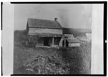
Catskill (town), New York
| Catskill, New York | |
|---|---|
| Town | |
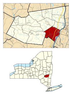 Location in Greene County and the state of New York. | |
| Coordinates: 42°13′16″N 73°51′59″W / 42.22111°N 73.86639°WCoordinates: 42°13′16″N 73°51′59″W / 42.22111°N 73.86639°W | |
| Country | United States |
| State | New York |
| County | Greene |
| Government | |
| • Type | Town Council |
| • Town Supervisor | Doreen Davis |
| • Town Council |
Members
|
| Area[1] | |
| • Total | 64.17 sq mi (166.19 km2) |
| • Land | 60.44 sq mi (156.54 km2) |
| • Water | 3.73 sq mi (9.65 km2) |
| Population (2010)[2] | |
| • Total | 6,670 |
| • Estimate (2016)[3] | 11,365 |
| • Density | 188.04/sq mi (72.60/km2) |
| Time zone | UTC-5 (Eastern (EST)) |
| • Summer (DST) | UTC-4 (EDT) |
| FIPS code | 36-039-13013 |
| Website |
www |
Catskill is a town in the southeast part of Greene County, New York, United States. The population was 11,775 at the 2010 census.[4] The western part of the town is in the Catskill Park. The town contains a village, also called Catskill. The village of Catskill has a well-defined Main Street. There is a public boat launch on the Hudson River called Dutchman's Landing.
History
The area of the town was purchased from the natives for some trinkets in 1678, and settlement followed. The town was established March 7, 1788, as part of Albany County. When Greene County was formed on March 25, 1800, Catskill became part of the new county.[5] The town was increased by an addition from the town of Woodstock in 1800, but was later decreased upon the formation of the towns of Cairo (1803) and Athens (1815).
Notable people
- Sybil Ludington, Revolutionary War Hero
- Jedediah Berry, author raised in Catskill
- James Bogardus, inventor, architect, pioneer of American cast-iron architecture, for which he took out a patent (1850)
- Mickey Brantley, outfielder for the Seattle Mariners who later went on to be a coach for the Toronto Blue Jays and New York Mets; born and raised in Catskill
- Robert Charels (Robert Smith), blues singer who has recorded three albums nationally (including the Duke Robillard-produced Metropolitan Blue); born and raised in Catskill
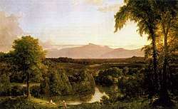
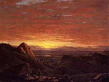
- Frederic Edwin Church, American landscape painter
- Thomas Cole, founder of the Hudson River School of painting, lived in Catskill from 1827 until his death in 1848. Cole was a member of Saint Luke's Episcopal Church in Catskill, and designed the present church building; a stained-glass window there honors the Cole family. His house at Cedar Grove is open to the public.
- Cus D'Amato, boxing manager who formed a gym in Catskill where he trained future heavyweight champion Mike Tyson
- Edward W. Dwight, Wisconsin politician born in Catskill
- John Hill, New Jersey politician born in Catskill
- Tom Judson, Broadway actor and composer
- George W. Lay (1798–1860), U.S. congressman
- Hugh Malone, Alaska state legislator, born in Catskill
- Charles Palmetier, Wisconsin state senator, born in Catskill
- Jaap Penraat, Dutch resistance fighter during World War II
- Robert Seaman, millionaire entrepreneur, born in Catskill
- Jeremy Transue, Alpine skier
- Mike Tyson, champion heavyweight boxer; moved to Catskill from Brooklyn in 1980, trained at local gym[6]
- Abraham Van Vechten, New York State Attorney General, born in Catskill
Geography
According to the United States Census Bureau, the town has a total area of 64.2 square miles (166.2 km²), of which 60.5 square miles (156.8 km²) is land and 3.7 square miles (9.5 km², or 5.69%) is water.
The east town line is defined by the Hudson River, forming the border of Columbia County. The south town line is the border of Ulster County.
The New York State Thruway (Interstate 87) and U.S. Route 9W pass through the town.
On July 23, 2003, an F2 tornado ripped across the town. The worst of the damage occurred at the Kiskatom flats. The tornado crossed over New York Route 32 and went past the Friar Tuck Inn, causing two mobile homes to flip over.
Demographics
| Historical population | |||
|---|---|---|---|
| Census | Pop. | %± | |
| Est. 2016 | 11,365 | [3] | |
| U.S. Decennial Census[7] | |||
As of the census[8] of 2000, there were 11,849 people, 4,780 households, and 3,035 families residing in the town. The population density was 195.8 people per square mile (75.6/km²). There were 5,700 housing units at an average density of 94.2 per square mile (36.4/km²). The racial makeup of the town was 89.84% White, 6.03% Black or African American, 0.32% Native American, 0.61% Asian, 0.02% Pacific Islander, 0.86% from other races, and 2.32% from two or more races. Hispanic or Latino of any race were 4.03% of the population.
There were 4,780 households out of which 28.4% had children under the age of 18 living with them, 45.5% were married couples living together, 13.3% had a female householder with no husband present, and 36.5% were non-families. 29.7% of all households were made up of individuals and 12.1% had someone living alone who was 65 years of age or older. The average household size was 2.38 and the average family size was 2.94.
In the town, the population was spread out with 23.5% under the age of 18, 7.1% from 18 to 24, 27.3% from 25 to 44, 24.2% from 45 to 64, and 17.9% who were 65 years of age or older. The median age was 40 years. For every 100 females, there were 90.7 males. For every 100 females age 18 and over, there were 88.6 males.
The median income for a household in the town was $33,531, and the median income for a family was $42,807. Males had a median income of $33,832 versus $25,058 for females. The per capita income for the town was $18,563. About 11.2% of families and 14.9% of the population were below the poverty line, including 21.4% of those under age 18 and 9.7% of those age 65 or over.
Communities and locations in the town
- Alsen – A hamlet in the southeast part of the town on Route 9W.
- Cairo Junction – A hamlet in the northwest part of the town.
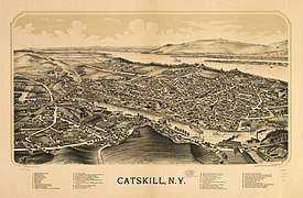
- Catskill – A village that is the primary settlement in the town, located in the northeast on both sides of Catskill Creek.
- Cauterskill – A hamlet west of Catskill village.
- Hamburg – A hamlet north of Catskill village on the Hudson River.
- High Falls – A hamlet by the south town line.
- Jefferson Heights – A hamlet and census-designated place northwest of Catskill village.
- Kiskatom – A hamlet southwest of Catskill village.
- Lawrenceville – A hamlet in the western part of the town.
- Leeds – A hamlet and census-designated place by the north town line.
- Palenville – A hamlet and census-designated place in the southwest corner of the town.
- Smith's Landing – A hamlet south of Alsen on Route 9W.
References
- ↑ "2016 U.S. Gazetteer Files". United States Census Bureau. Retrieved Jul 5, 2017.
- ↑ "American FactFinder". United States Census Bureau. Retrieved 2011-05-14.
- 1 2 "Population and Housing Unit Estimates". Retrieved June 9, 2017.
- ↑ "Geographic Identifiers: 2010 Demographic Profile Data (G001): Catskill town, Greene County, New York". American Factfinder. U.S. Census Bureau. Retrieved December 29, 2016.
- ↑ "RootsWeb.com Home Page". www.rootsweb.ancestry.com. Retrieved 23 March 2018.
- ↑ Mehta, Seema (July 6, 1997). "In Catskill, They Knew Mike Tyson At The Start". The Seattle Times (from Associated Press). Retrieved 26 December 2017.
- ↑ "Census of Population and Housing". Census.gov. Retrieved June 4, 2016.
- ↑ "American FactFinder". United States Census Bureau. Archived from the original on 2013-09-11. Retrieved 2008-01-31.
External links
| Wikimedia Commons has media related to Catskill, New York. |
- Town of Catskill official website
- Cedar Grove – Thomas Cole Historic site

Municipalities and communities of Greene County, New York, United States | ||
|---|---|---|
| Towns | 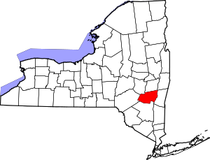 | |
| Villages | ||
| CDPs | ||
| Other hamlets | ||