Henry Hudson Bridge
| Henry Hudson Bridge | |
|---|---|
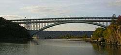
 View from Inwood Hill Park | |
| Coordinates | 40°52′40″N 73°55′18″W / 40.877861°N 73.921777°WCoordinates: 40°52′40″N 73°55′18″W / 40.877861°N 73.921777°W |
| Carries |
7 lanes (3 upper, 4 lower) of |
| Crosses | Spuyten Duyvil Creek |
| Locale | Spuyten Duyvil, Bronx and Inwood, Manhattan, New York City |
| Official name | Henry Hudson Bridge |
| Maintained by | MTA Bridges and Tunnels |
| Characteristics | |
| Design | Double-decker arch bridge |
| Total length | 2,208 ft (673 m) |
| Width |
3 lanes (upper deck) 4 lanes (lower deck) |
| Longest span | 841 ft (256 m) |
| Clearance above | 12 ft (4 m) |
| Clearance below | 143 ft (44 m) |
| History | |
| Designer | David B. Steinman |
| Opened | December 12, 1936 |
| Statistics | |
| Daily traffic | 62,648 (2016)[1] |
| Toll | As of March 19, 2017, $6.00 (tolls by mail); $2.64 (New York E-ZPass) |
 Henry Hudson Bridge Location in New York City  Henry Hudson Bridge Henry Hudson Bridge (New York)  Henry Hudson Bridge Henry Hudson Bridge (the US) | |
The Henry Hudson Bridge is a steel arch toll bridge in New York City across the Spuyten Duyvil Creek. It connects Spuyten Duyvil in the Bronx with Inwood in Manhattan to the south, via the Henry Hudson Parkway (NY 9A). On the Manhattan side, the parkway goes into Inwood Hill Park. Commercial vehicles are not permitted on this bridge, since commercial vehicles are not allowed on the parkway in general.
Design

The bridge was designed by David B. Steinman, drawing upon his 1911 Ph.D. thesis in civil engineering at Columbia University.[2][3] Named to commemorate the voyage of Henry Hudson on the Half Moon, which anchored near the site in 1609,[4][5] it was the longest plate girder arch and fixed arch bridge in the world when it opened in 1936.[4]
The bridge has two roadway levels carrying an aggregate of seven traffic lanes and a pedestrian walkway and spans Spuyten Duyvil Creek just east of where the tidal strait meets the Hudson River.[6] The bridge is part of the Henry Hudson Parkway designated as New York State Route 9A. To its west, at five feet above water level, is the Spuyten Duyvil Bridge, which is used by Amtrak trains heading to Albany, New York and other points north. The Spuyten Duyvil Metro-North station is located under the Henry Hudson Bridge on the Bronx side.
History
A bridge at this location was proposed as early as 1906, but Spuyten Duyvil residents and other civic groups opposed the bridge, arguing that it would destroy the virgin forest of Inwood Hill Park and bring traffic congestion to the communities on the Bronx side of the river. Meanwhile, Robert Moses preferred the route along the Hudson River because he was able to receive the land to build the Henry Hudson Parkway at no cost and use federal labor to construct the parkway.[7][8] The construction of the bridge helped open the Riverdale neighborhood to development.[9]
The original single-deck structure was built for the Henry Hudson Parkway Authority by the American Bridge Company at a cost of $4,949,000 and opened to traffic on December 12, 1936.[4][10] The upper level of the bridge was designed to be added at a later date and opened to traffic on May 7, 1938.[11] The second deck was added an additional cost of approximately $2,000,000, after increasing toll revenues enabled its construction.[7]
The bridge is owned by the City of New York and operated by the MTA Bridges and Tunnels, an affiliate agency of the Metropolitan Transportation Authority. A rehabilitation project commenced in 2000 and was carried out by Steinman, Boynton, Gronquist and Birdsall, a successor firm of Robinson & Steinman, the firm that originally designed and engineered the bridge.
Tolls
As of March 19, 2017, drivers pay $6.00 per car and $3.50 per motorcycle for tolls by mail. E‑ZPass users with transponders issued by the New York E‑ZPass pay $2.64 per car and $1.80 per motorcycle. All other E-ZPass users with transponders issued outside of the NY Customer Service Center (except the Port Authority of New York and New Jersey E-Z Pass) pay Toll-by-mail rates.[12]
In January 2010, the MTA announced that it planned to implement a pilot program on the Henry Hudson Bridge to phase out toll booths and use open road tolling. On January 20, 2011, this toll pilot project got underway.[13][14][15] Drivers without E-ZPass are sent a bill in the mail. The new tolling system was implemented on November 10, 2012, and has since been implemented on all nine MTA crossings.[16]
On November 20, 2016, the tollbooths were dismantled, as drivers were no longer able to pay cash at the bridge. Instead, there are cameras mounted onto new overhead gantries near where the booths were located.[17][18] Drivers without E-ZPass have a picture of their license plate taken, and a bill for the toll is mailed to them. For E-ZPass users, sensors detect their transponders wirelessly.[17][18]
References
Notes
- ↑ "New York City Bridge Traffic Volumes" (PDF). New York City Department of Transportation. 2016. p. 11. Retrieved March 16, 2018.
- ↑ Weingardt, Richard (2005). Engineering Legends: Great American Civil Engineers: 32 Profiles of Inspiration and Achievement. Reston, VA: American Society of Civil Engineers. p. 68. ISBN 0-7844-0801-7.
- ↑ Reier, Sharon (2000). The Bridges of New York. Mineola, NY: Dover Publications. pp. 132–134. ISBN 0-486-41230-X.
- 1 2 3 "Henry Hudson Bridge". MTA Bridges and Tunnels. Archived from the original on July 23, 2011. Retrieved March 6, 2010.
- ↑ McNamara, John (1984). History in Asphalt: The Origin of Bronx Street and Place Names. Bronx, NY: Bronx County Historical Society. p. 104. ISBN 0-941980-16-2.
- ↑ Sheraton, Mimi (April 2, 1999). "Seven Strolls In the Sky". The New York Times. Retrieved March 6, 2010.
- 1 2 Gray, Christopher (August 10, 2003). "Henry Hudson Bridge; A Controversial '36 Span Through Dreamy Isolation". The New York Times. Retrieved March 6, 2010.
- ↑ "For A Henry Hudson Bridge; Board of Estimate Will Approve $2,000,000 To-day to Build It". The New York Times. April 6, 1906. Retrieved March 6, 2010.
- ↑ Garb, Margaret (March 1, 1998). "If You're Thinking of Living In Riverdale, the Bronx; A Community Jealous of Its Open Space". The New York Times. Retrieved March 6, 2010.
- ↑ "The New Parkways". The New York Times. December 12, 1936. Retrieved February 21, 2010.
- ↑ "Henry Hudson Span Opens Upper Level". The New York Times. May 8, 1938. Retrieved February 21, 2010.
- ↑ "2017 Toll Information". MTA Bridges & Tunnels. Retrieved March 16, 2017.
- ↑ Mancini, John (January 20, 2011). "Henry Hudson Span Goes "Gateless" - NY1". NY1. Archived from the original on July 14, 2014. Retrieved July 13, 2014.
- ↑ "Henry Hudson Bridge Toll Pilot". MTA YouTube website. January 20, 2011. Retrieved January 20, 2011.
- ↑ "MTA | news | Gate Free E-ZPass on the Henry Hudson Reducing Travel Time". MTA.info. February 22, 2011. Retrieved July 13, 2014.
- ↑ "Cashless tolls at the Henry Hudson Bridge". MTA Bridges and Tunnels. Retrieved October 3, 2012.
- 1 2 Siff, Andrew (October 5, 2016). "Automatic Tolls to Replace Gates at 9 NYC Spans: Cuomo". NBC New York. Retrieved December 25, 2016.
- 1 2 WABC (December 21, 2016). "MTA rolls out cashless toll schedule for bridges, tunnels". ABC7 New York. Retrieved December 25, 2016.
Further reading
- New York Times: "For Crossing Built Long Ago, No End to the Repairs" December 12, 2011
External links

- NYC Roads entry
- Henry Hudson Bridge at Structurae
Crossings of the Harlem River | ||||
|---|---|---|---|---|
| ||||