Triborough Bridge
Route map:
| Robert F. Kennedy Bridge (Triborough Bridge) | |
|---|---|
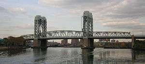
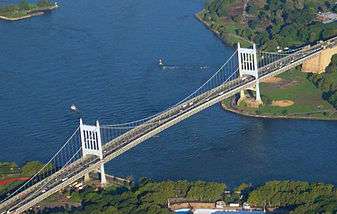 Aerial view of the Queens–Wards Island span of the Triborough Bridge, over the East River; Queens is in the foreground | |
| Coordinates | 40°46′50″N 73°55′38″W / 40.780488°N 73.927168°W |
| Carries |
8 lanes of 6 lanes of NY 900G (Manhattan span) |
| Crosses | East River, Harlem River and Bronx Kill |
| Locale | New York City, United States |
| Official name | Robert F. Kennedy Bridge |
| Other name(s) | Triborough Bridge, RFK Triborough Bridge, Triboro Bridge, RFK Bridge |
| Maintained by | MTA Bridges and Tunnels |
| Characteristics | |
| Design | Suspension bridge, lift bridge, truss bridge |
| Total length |
2,780 feet (850 m) (Queens span) 770 feet (230 m) (Manhattan span) 1,600 feet (490 m) (Bronx span) |
| Width | 98 feet (30 m) (Queens span) |
| Longest span |
1,380 feet (420 m) (Queens span) 310 feet (94 m) (Manhattan span) 383 feet (117 m) (Bronx span) |
| Clearance above |
14 feet 6 inches (4.42 m) (Queens / Bronx spans) 13 feet 10 inches (4.22 m) (Manhattan span) |
| Clearance below |
143 feet (44 m) (Queens span) 135 feet (41 m) (Manhattan span when raised) 55 feet (17 m) (Bronx span) |
| History | |
| Opened | July 11, 1936 |
| Statistics | |
| Daily traffic |
95,552 (Queens–Manhattan and Bronx–Manhattan, 2016)[1] 83,053 (Queens–Bronx, 2016)[1] |
| Toll | As of March 19, 2017, $8.50 (Tolls By Mail and non-New York E-ZPass); $5.76 (New York E-ZPass) |
 Robert F. Kennedy Bridge (Triborough Bridge) Point where the three spans meet | |
The Triborough Bridge, known officially as the Robert F. Kennedy Bridge since 2008, and sometimes referred to as the RFK Triborough Bridge or RFK Bridge, is a complex of three separate bridges and their connecting viaducts or elevated expressways[2] in New York City. The complex of bridges and elevated roads serves to connect three boroughs, Manhattan, Queens, and the Bronx. The viaducts were built on Randalls and Wards Islands, previously two islands which are now joined as one by landfill.
The bridge complex, which carries Interstate 278 and unmarked New York State Route 900G, connects with the FDR Drive and the Harlem River Drive in Manhattan, the Bruckner Expressway and the Major Deegan Expressway in the Bronx, and the Grand Central Parkway and Astoria Boulevard in Queens.
The three bridges of the Triborough Bridge complex are:[2]
- The Harlem River vertical-lift bridge, the largest in the world, which connects Manhattan to Randalls Island
- The Bronx Kill truss bridge, which connects Randalls Island to the Bronx
- The suspension bridge over Hell Gate (a strait of the East River), which connects Wards Island to Astoria in Queens
These three bridges are connected by an elevated highway viaduct across Randalls and Wards Islands and 14 miles (23 km) of support roads.[2][3] Also part of the complex is a grade-separated T-interchange on Randalls Island, which sorted out traffic in a way that ensured that drivers paid a toll at only one bank of toll booths.[4] The toll booths have since been removed since all tolls are collected electronically at the approaches to each bridge.
The bridge complex was designed by chief engineer Othmar H. Ammann and architect Aymar Embury II,[5] and has been called the "biggest traffic machine ever built".[4] The American Society of Civil Engineers designated the Triborough Bridge Project as a National Historic Civil Engineering Landmark in 1986.[6]
The bridge is owned and operated by MTA Bridges and Tunnels, a division of the Metropolitan Transportation Authority.
History
Planning and construction
Plans for connecting Manhattan, Queens and the Bronx were first announced by Edward A. Byrne, chief engineer of the New York City Department of Plant and Structures, in 1916.[7] While such a bridge complex's construction had long been recommended by local officials, the project failed to receive funding until 1925, when the city appropriated money for surveys, test borings and structural plans.[3]

Construction began on October 25, 1929 – Black Friday – and soon the Triborough project's outlook began to look bleak. Chief engineer Othmar Ammann, who had collapsed the original design's two-deck roadway into one, requiring lighter towers, and thus, lighter piers, saving $10 million on the towers alone, was enlisted again to help guide the project, but the combination of Tammany Hall graft, the stock market crash, and the Great Depression which followed it, brought the project to a virtual halt,[8] as investors shied away from purchasing the municipal bonds needed to fund it.[5] By the spring of 1932, the project was moribund.[9]
The project was resurrected by Robert Moses, who pushed the state legislature to create the Triborough Bridge Authority (TBA) to fund, build and operate it. Moses was confronted by a situation where the city had not planned any of the necessary approaches to the structure, or even bought up the property that would clearly be needed to build those roads, property which they could have gotten at bargain prices early on.[8] Moses solved this problem in typical fashion by proposing new roads and parkways to feed into the bridge, which would connect it to the existing ones he had already built. The complex of roads included the Grand Central Parkway and Astoria Boulevard in Queens, an extension to the East River Drive (now the FDR Drive) in Manhattan, and Whitlock Avenue and Eastern Boulevard in the Bronx.[4]
While reformers embraced Moses' plans, state and city officials were overwhelmed by their scale, and slow to move to provide financing for the vast system.[8] Moses leveraged his leadership of the Authority – after he wrenched control of it away from Tammany – as well as the state and city positions he also held, to start the project up again, with construction resuming in November 1933.[9] Eventually, funding would come from the city and from the Federal government under New Deal programs such as the Public Works Administration (PWA), the latter of which involved complex political infighting between Moses, PWA Administrator Harold L. Ickes, President Franklin Delano Roosevelt and New York City Mayor Fiorello H. LaGuardia, over which Moses almost lost his job.[10] The other major source of funding was from interest-bearing bonds issued by the Triborough Bridge Authority itself, and not by the city. These bonds were secured by future toll revenue.[11][12]
The scale of the Triborough Bridge project, including its approaches, was such that hundreds of large apartment buildings were demolished to make way for it. The structure used concrete from factories "from Maine to the Mississippi", and steel from 50 mills in Pennsylvania. To make the formwork for pouring the concrete, a forest's worth of trees on the Pacific Coast was cut down.[4] Robert Caro, the biographer of Moses, said about it:
Triborough was not a bridge so much as a traffic machine, the largest ever built. The amount of human energy expended in its construction gives some idea of its immensity: more than five thousand men would be working at the site, and these men would only be putting into place the materials furnished by the labor of many times five thousand men; before the Triborough Bridge was completed, its construction would have generated more than 31,000,000-man hours of work in 134 cities in twenty states.[4]
The completed structure, described by The New York Times as a "Y-shaped sky highway", was dedicated on July 11, 1936, at ceremonies held on the central span which were attended by President Roosevelt, Mayor La Guardia, New York State Governor Herbert H. Lehman, Public Works Administrator Ickes, Postmaster General James A. Farley and Moses, who acted as master of ceremonies.[13][3][14] Due to the previous conflicts between himself and Moses, the attendance of Roosevelt was not certain until the last minute. The ceremonies were broadcast via a nationwide radio connection.[14]
The total cost of the bridge, the largest PWA project in the East, was more than $60 million (equivalent to $1058.13 million in 2017) – one of the largest public works projects of the Great Depression, more expensive than the Hoover Dam.[15][3][14] Of this, $16 million came from the city and $9 million directly from the PWA, which also purchased $35 million worth of TBA bonds, which were eventually bought back and resold to the public.[9] In the first year of the bridge's operation it generated $2.72 million (equivalent to $46.30 million in 2017) – produced by 9.65 million vehicles.[5]
A by-product of the Triborough project was the creation of parks and playgrounds in the lands underneath the bridges and approaches on Wards and Randalls Island (see Randall's Island Park), in Astoria, and in Manhattan.[9]
Recent events
Motorists were first able to pay with E‑ZPass in lanes for automatic coin machines at the Randalls Island toll plazas on August 21, 1996.[16]
At some point in the past, a sign on the bridge informed travelers, "In event of attack, drive off bridge," New York Times columnist William Safire wrote in 2008. The "somewhat macabre sign", he wrote, must have "drawn a wry smile from millions of motorists."[17]
On November 19, 2008, the Triborough Bridge was officially renamed after Robert F. Kennedy at the request of the Kennedy family.[18] Forty years had passed since the New York United States Senator and former U.S. Attorney General had been assassinated during a 1968 presidential bid.[19][20][21] Traffic and news reports have come to commonly refer to the bridge as the "RFK Triborough Bridge" and at times simply the "Triborough Bridge" to avoid confusion among residents long accustomed to its original name.[22]
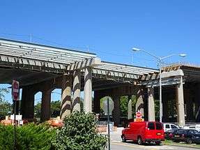
In 2015, the MTA started two reconstruction projects on different parts of the bridge[23] as part of a $1 billion, 15-year program to renovate the bridge complex.[24] The MTA commenced construction on a $213 million rehabilitation of the 1930s-era toll plaza between the Queens and Bronx spans, which included a rebuilding of the roadway and the supporting structure underneath. The new tollbooth structure is to be completed in 2019.[23] In addition, a ramp from the Manhattan span to the northbound Harlem River Drive was being built for $68.3 million, with the ramp to be finished by December 2017. [23] Cashless tolling, a program that eliminates toll gates and allows drivers to maintain highway speeds across the span, was implemented on June 15, 2017. Tolls are either collected electronically by EZ Pass transponder or by mail using data collected by license plate readers. [23]
Usage
The toll revenues from the Triborough Bridge pay for a portion of the public transit subsidy for the New York City Transit Authority and the commuter railroads.[25] The bridge had annual average daily traffic of 164,116 in 2014. For that year, the bridge saw annual toll-paying traffic rise by 2.9% to 59.9 million, generating $393.6 million in revenue at an average toll of $6.57.[26]
The bridge has sidewalks in all three legs where the TBTA officially requires bicyclists to walk their bicycles across[27] due to safety concerns.[28] However, the signs stating this requirement have been usually ignored by bicyclists,[29] while the New York City Government has recommended that the TBTA should reassess this kind of bicycling ban.[30] Stairs on the 2 km (1.2 mi) Queens leg impede handicapped access. The Queens stairway along the southern side was demolished at the beginning of the 21st century, thus isolating that walkway, but the ramp of the Wards Island end of the walkway along the northern side was improved in 2007. The two sidewalks of the Bronx span are connected to only one ramp at the Randalls Island end.
Tolls
As of March 19, 2017, drivers pay $8.50 per car or $3.50 per motorcycle for tolls by mail. E‑ZPass users with transponders issued by the New York E‑ZPass Customer Service Center pay $5.76 per car or $2.51 per motorcycle. All E-ZPass users with transponders not issued by the New York E-ZPass CSC will be required to pay Toll-by-mail rates.[31]
Open-road cashless tolling began on June 15, 2017.[32] The tollbooths were dismantled, and drivers are no longer able to pay cash at the bridge. Instead, there are cameras mounted onto new overhead gantries near where the booths were formerly located.[33][34] Drivers without E-ZPass will have a picture of their license plate taken, and the toll will be mailed to them. For E-ZPass users, sensors will detect their transponders wirelessly.[33][34]
Public transportation
The Triborough Bridge carries the M35, M60 SBS, and X80 bus routes operated by MTA New York City Transit, and nine express bus routes operated by the MTA Bus Company: BxM1, BxM2, BxM6, BxM7, BxM8, BxM9, BxM10, BxM11, and BxM18.[35]
In the 1920s, New York's Transit Commission considered extending the BMT Astoria Line along the same route the Triborough now follows. The proposal would have created a crosstown subway line along 125th Street.[36]


Statistics
East River suspension bridge (I-278)
- Span crosses the East River at the Hell Gate between Queens and Wards Island
- Connects to Grand Central Parkway and Brooklyn–Queens Expressway
- Length of main span: 1,380 feet (421 m)
- Length of each side span: 700 feet (213 m)
- Length, anchorage to anchorage: 2,780 feet (847 m)[3]
- Width of bridge: 98 feet (30 m)
- Height of towers above mean high water: 315 feet (96 m)
- Clearance at center above mean high water: 143 feet (44 m)
- Number of traffic lanes: 8 lanes
- Number of sidewalks: 1
Harlem River lift bridge (NY 900G)
- Span crosses the Harlem River between Manhattan and Randalls Island
- Connects to Harlem River Drive, FDR Drive, and 125th Street
- Length of main lift-truss span: 310 feet (94 m)
- Length of each side truss span: 195 feet (59 m)
- Length, anchorage to anchorage: 700 feet (213 m)[3]
- Height of towers: 210 feet (64 m)
- Clearance of lift span above mean high water: 55 feet (17 m)
- Clearance of lift span in raised position: 135 feet (41 m)
- Number of traffic lanes: 6 lanes
- Number of sidewalks: 2 (1 on each side)
Bronx Kill crossing (I-278)
- Span crosses the Bronx Kill between The Bronx and Randalls Island
- Connects to Major Deegan Expressway and Bruckner Expressway
- Length of main truss span: 383 feet (117 m)
- Length of approach truss span: 1,217 feet (371 m)[3]
- Length, anchorage to anchorage: 1,600 feet (488 m)
- Clearance of truss span above mean high water: 55 feet (17 m)
- Number of traffic lanes: 8 lanes
- Number of sidewalks: 2 (1 on each side)
See also

- List of bridges documented by the Historic American Engineering Record in New York
- National Register of Historic Places listings in New York County, New York
- National Register of Historic Places listings in Queens County, New York
- National Register of Historic Places listings in Bronx County, New York
- List of reference routes in New York
References
Notes
- 1 2 "New York City Bridge Traffic Volumes" (PDF). New York City Department of Transportation. 2016. p. 11. Retrieved March 16, 2018.
- 1 2 3 "Robert F. Kennedy Bridge". Metropolitan Transportation Authority. Retrieved November 3, 2015.
The Robert F. Kennedy Bridge (formerly the Triborough Bridge), the authority's flagship facility, opened in 1936. It is actually three bridges, a viaduct, and 14 miles of approach roads connecting Manhattan, Queens, and the Bronx.
- 1 2 3 4 5 6 7 See:
- "Triboro Plaza Highlights : NYC Parks". New York City Department of Parks & Recreation. Retrieved November 3, 2015.
- "Triborough Bridge Playground B Highlights : NYC Parks". New York City Department of Parks & Recreation. Retrieved November 3, 2015.
- 1 2 3 4 5 Caro (1974), pp.386–95
- 1 2 3 Shanor, Rebecca Read. "Robert F. Kennedy Memorial Bridge [Triborough Bridge]" in Jackson, Kenneth T., ed. (2010), The Encyclopedia of New York City (2nd ed.), New Haven: Yale University Press, ISBN 978-0-300-11465-2 , p.1110
- ↑ "Triborough Bridge Project". ASCE Metropolitan Section. Retrieved November 12, 2016.
- ↑ "Triboro Plaza". New York City Department of Parks & Recreation. Retrieved February 25, 2010.
- 1 2 3 Caro (1974), pp.340–44
- 1 2 3 4 Federal Writers' Project (1939), New York City Guide, New York: Random House, ISBN 0-403-02921-X (Reprinted by Scholarly Press, 1976; often referred to as WPA Guide to New York City), pp.392–94
- ↑ Caro (1974), pp.426–40
- ↑ Caro (1974), p.345
- ↑ The bonds not only helped to finance the project, but also assured that the Authority would be self-perpetuating and immune from legislative oversight, as the Authority's contractual obligations to the bond-holders were paramount and could not, according to the Authority's legal theory, be altered by legislative action. They also assured that the Triborough would never be toll free. Caro (1974), pp.1119–22
- ↑ Staff. (July 12, 1936) "Great Link is Acclaimed; People Demanding Such Up-to-Date Projects, Roosevelt Says", The New York Times. Accessed November 3, 2015
- 1 2 3 Caro (1974), pp.440–43
- ↑ Roberts, Sam (July 11, 2006). "Reappraising a Landmark Bridge, and the Visionary Behind It". The New York Times. Retrieved February 25, 2010.
- ↑ Purdy, Matthew (August 22, 1996). "Drivers Give Passing Grade To E-Z Pass In Major Test". The New York Times. Retrieved February 25, 2010.
- ↑ Safire, William (July 13, 2008). "On Language: Dead End". The New York Times. Retrieved December 4, 2008.
- ↑ Gershman, Jacob (January 8, 2008). "Enduring Wish May Come True in RFK Bridge". The New York Sun. Retrieved January 9, 2008.
- ↑ Associated Press (January 8, 2008). "Triborough Bridge may be renamed for Robert F. Kennedy". New York Daily News. Retrieved January 9, 2008.
- ↑ Metropolitan Transportation Authority (November 21, 2008). "Triborough Bridge Renamed Robert F. Kennedy Bridge" (Press release). Retrieved December 4, 2008.
- ↑ Chan, Sewell (November 19, 2008). "The Triborough Is Officially the R.F.K. Bridge". The New York Times. Retrieved December 4, 2008.
- ↑ de Kretser, Leela (May 6, 2010). "U-Haul Abandoned on R.F.K.-Triborough Bridge". DNAinfo. Archived from the original on March 6, 2012. Retrieved December 5, 2011.
- 1 2 3 4 "MTA | news | Two Capital Improvement Projects At Flagship Robert F. Kennedy Bridge Underway". www.mta.info. Retrieved December 28, 2016.
- ↑ "RFK Bridge Gets $1 B Capital Improvement, Project To Take 15 Years; GAHS 75th Anniversary Photo Exhibit". Queens Gazette. July 6, 2011. Retrieved December 28, 2016.
- ↑ Steinhauer, Jennifer (February 13, 1994). "F.Y.I." The New York Times. Retrieved February 25, 2010.
- ↑ "Appendix E: History and Projection of Traffic, Toll Revenues and Expenses and Review of Physical Conditions of the Facilities of Triborough Bridge and Tunnel Authority", Stantec for the Triborough Bridge and Tunnel Authority, April 30, 2015. Accessed November 5, 2015.
- ↑ MTA Bridges & Tunnels (October 1, 2003). "Rules and Regulations Governing the Use of the Triborough Bridge and Tunnel Authority Facilities" (PDF). Section 1022.1(e). Retrieved February 20, 2010.
- ↑ "MTA Bike & Ride". Metropolitan Transportation Authority. Retrieved February 20, 2010.
- ↑ "New York City Bicycle Master Plan" (PDF). New York City Department of City Planning. May 1997. p. 16. Retrieved February 20, 2010.
- ↑ "New York City Bicycle Master Plan" (PDF). New York City Department of City Planning. May 1997. p. 57. Retrieved February 20, 2010.
- ↑ "2017 Toll Information". MTA Bridges & Tunnels. Retrieved March 16, 2017.
- ↑ "Cashless Tolls Arrive on RFK Triboro Bridge". Spectrum News NY1 | New York City. June 15, 2017. Retrieved February 16, 2018.
- 1 2 Siff, Andrew (October 5, 2016). "Automatic Tolls to Replace Gates at 9 NYC Spans: Cuomo". NBC New York. Retrieved December 25, 2016.
- 1 2 WABC (December 21, 2016). "MTA rolls out cashless toll schedule for bridges, tunnels". ABC7 New York. Retrieved December 25, 2016.
- ↑
- "Queens Bus Map" (PDF). Metropolitan Transportation Authority. December 2017. Retrieved April 24, 2018.
- "Manhattan Bus Map" (PDF). Metropolitan Transportation Authority. December 2017. Retrieved April 24, 2018.
- ↑ "New subways: proposed additions to rapid transit system to cost $218,000,000 ..." MOA website (University of Michigan)
Bibliography
- Caro, Robert (1974). The Power Broker. New York: Vintage Books. ISBN 0-394-72024-5.
External links
| Wikimedia Commons has media related to Triborough Bridge. |
- Official website
- Triborough Bridge historic overview at nycroads.com
- Historic American Engineering Record (HAER) No. NY-301, "Triborough Bridge, Passing through Queens, Manhattan & the Bronx, Queens, Queens County, NY", 28 photos, 3 photo caption pages
- Triborough Bridge at Structurae
- Triborough Bridge Harlem River Lift Span at Structurae
Crossings of the East River | ||||
|---|---|---|---|---|
| ||||