Salisbury Center Bridge
| Salisbury Center Bridge | |
|---|---|
| Coordinates | 43°08′28″N 74°47′17″W / 43.141°N 74.788°WCoordinates: 43°08′28″N 74°47′17″W / 43.141°N 74.788°W |
| Crosses | Spruce Creek |
|
Salisbury Center Covered Bridge | |
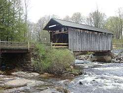 Salisbury Covered Bridge, May 2008 | |
  | |
| Location | Fairview Rd. over Spruce Creek, Salisbury, Herkimer County, New York |
|---|---|
| Coordinates | 43°8′26.97″N 74°47′16.83″W / 43.1408250°N 74.7880083°WCoordinates: 43°8′26.97″N 74°47′16.83″W / 43.1408250°N 74.7880083°W |
| Built | 1875 |
| Architect | Theodore Burr and Alvah Hopson |
| NRHP reference # | 72000848 |
| Added to NRHP | June 19, 1972 [1] |
Salisbury Center Bridge is the only covered bridge in Herkimer County, New York State. It was built in 1875, and is a wood frame Burr Truss bridge measuring 42 feet (13 metres) long and 16 feet (5 metres) wide. The bridge has vertical board siding and is topped by a gable roof.[2]:4 The wooden bridge is one of 29 covered bridges in New York State.
It was added to the National Register of Historic Places in 1972.[1]
References
- 1 2 National Park Service (2007-01-23). "National Register Information System". National Register of Historic Places. National Park Service.
- ↑ "Cultural Resource Information System (CRIS)" (Searchable database). New York State Office of Parks, Recreation and Historic Preservation. Retrieved 2015-11-01. Note: This includes T. Robins Brown (February 1972). "National Register of Historic Places Registration Form: Salisbury Center Bridge" (PDF). Retrieved 2015-11-01. and Accompanying photographs
External links
- Salisbury Center Bridge, at New York State Covered Bridge Society
- Salisbury Center Bridge, at Covered Bridges of the Northeast USA
| Topics |   | |
|---|---|---|
| Lists by county |
| |
| Lists by city | ||
| Other lists | ||
| ||
This article is issued from
Wikipedia.
The text is licensed under Creative Commons - Attribution - Sharealike.
Additional terms may apply for the media files.