Goethals Bridge
| Goethals Bridge | |
|---|---|
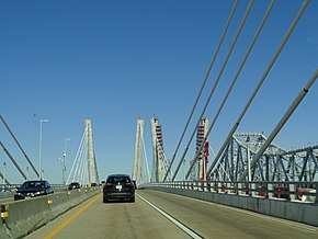 Traveling west over the new eastbound span in 2017, with the westbound span under construction at near right and the original span at far right | |
| Coordinates | 40°38′09″N 74°11′49″W / 40.6358°N 74.1969°WCoordinates: 40°38′09″N 74°11′49″W / 40.6358°N 74.1969°W |
| Carries |
6 lanes of |
| Crosses | Arthur Kill |
| Locale | Elizabeth, New Jersey and Howland Hook, Staten Island, New York, United States |
| Maintained by | Port Authority of New York and New Jersey |
| ID number | 3800072 |
| Characteristics | |
| Design |
Cantilever bridge (Original) dual-span cable-stayed twin bridge (New span) |
| Total length | 7,109 ft (2,167 m)[1] |
| Width | 62 ft (19 m)[1] |
| Longest span | 672 ft (205 m)[1] |
| Clearance above | 14 ft (4.3 m) |
| Clearance below | 140 ft (43 m)[1] |
| History | |
| Opened |
June 29, 1928 (original span) June 10, 2017 (new eastbound span) May 21, 2018 (new westbound span) |
| Closed | June 9, 2017 (original span) |
| Statistics | |
| Daily traffic | 82,852 (2016)[2] |
| Toll |
(Eastbound only) As of December 6, 2015:
|
 Goethals Bridge Location in New Jersey and New York  Goethals Bridge Goethals Bridge (New York City)  Goethals Bridge Goethals Bridge (New York)  Goethals Bridge Goethals Bridge (the US) | |
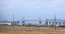
The Goethals Bridge (/ˈɡɒθəlz/ GOTH-əlz) is the name of a pair of cable-stayed bridge spans connecting Elizabeth, New Jersey, to Staten Island, New York, in the United States. The spans cross a strait known as Arthur Kill, and replace a cantilever bridge span built in 1929. The bridge is operated by the Port Authority of New York and New Jersey (PANYNJ).
The original cantilever span was one of the first structures built by the PANYNJ. The New Jersey side is about 2.5 miles (4 km) south of Newark Liberty International Airport. The bridge was grandfathered into Interstate 278, and named for Major General George Washington Goethals, who supervised construction of the Panama Canal and was the first consulting engineer of the PANYNJ.
In 2013, two new cable-stayed crossings, running parallel to the old cantilever bridge and replacing it, were approved. The new eastbound span opened on June 10, 2017, at which time the original span was closed. The new westbound span was opened on May 21, 2018. The old cantilever span was dismantled in January 2018.
Original bridge
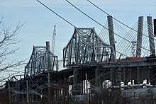
A steel truss cantilever design by John Alexander Low Waddell, who also designed the Outerbridge Crossing, the original Goethals was 672 ft (205 m) long central span, 7,109 feet (2,168 m) long in total, 62 feet (19 m) wide, had a clearance of 135 feet (41.1 m) and had four lanes for traffic.[3] The Port Authority had $3 million of state money and raised $14 million in bonds to build the Goethals Bridge and the Outerbridge Crossing; the Goethals bridge construction began on September 1, 1925 and cost $7.2 million (equivalent to $80,222,000 in 2016). It and the Outerbridge Crossing opened on June 29, 1928.[4]
The original Goethals Bridge replaced three ferries and is the immediate neighbor of the Arthur Kill Rail Bridge. Its unusual[3] mid-span height was a requirement of the New Jersey ports. The bridge was named for Major General George Washington Goethals, who supervised construction of the Panama Canal and was the first consulting engineer of the PANYNJ.[5]
Connecting onto the New Jersey Turnpike, it serves as one of the main routes for traffic between New Jersey and Brooklyn via the Staten Island Expressway and the Verrazano-Narrows Bridge. The original Goethals Bridge did not recoup its construction costs until the Verrazano-Narrows Bridge was completed in 1964, facilitating regional through-traffic across Staten Island to Brooklyn. The same was true of the Outerbridge Crossing. The total traffic in 2002 was 15.68 million vehicles.
The original Goethals Bridge had two 10-foot-wide (3.0 m) lanes in each direction, which did not meet the 12-foot (3.7 m) requirement of modern highway design standards. The bridge also had no shoulders for emergency access, or pedestrian walkways or bike paths. Its replacement bridge (twin, cable-stayed structures) was designed to address these deficiencies. An initial study in 1997 concluded that the optimal solution would be a parallel span. However, a more recent study suggested that the original span had only 10 years of life left, even with the recent deck rehabilitation, and that the optimal solution was an entirely new span. The choosing of the full replacement option was followed by the submittal of several design alternatives, alongside a "no build" option. The new bridge design, upon the completion of the westbound span, also include additional lanes of traffic, high-speed E-ZPass lanes, and a reconstruction and widening of Interstate 278 from exit 4 in New York (NY 440 South) to NJ 439 in New Jersey. The span was demolished starting in January 2018, after the opening of the replacement bridges.[6]
New bridge
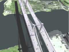
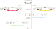
The initial alternatives put forth in summer 2006 included the option of twin three-lane replacement bridges north and south of the original alignment, which was completely eliminated; and twin three-lane replacement bridges (one south, and one along the original alignment), with the latter being built after the demolition of the original bridge, which was refined to be a single-span bridge instead of twin bridges. The reason for the dropping of twin-bridge alternatives in fall 2007 was a request by the FAA to decrease the height of the bridge's towers to prevent interference with flights into and out of Newark Liberty International Airport. Public open houses were held in Staten Island and Elizabeth, and the Draft Environmental Impact Statement (DEIS) was issued. Formal public hearings on the DEIS were held in July 2009.[7]
All alternatives proposed that the bridge be single level, cable-stayed, double spans, separated by towers with a height of 135 feet (41 m) above the high-water mark of the Arthur Kill shipping channel. Each deck would have three 12 ft (3.7 m) lanes with a 12 ft (3.7 m) outer shoulder and 5 ft (1.5 m) inner shoulder and the northern deck would feature a 10 ft (3.0 m) pedestrian walkway. In addition, permanent access roads would be built under the bridge on land for maintenance, security, and construction purposes.[8] Lastly, space would be left in between the two bridges to accommodate potential mass-transit services.[9][10]
For mass transit, studies indicated that a bus-only lane was not economically viable but that a high-occupancy vehicle lane open to buses as well as high-occupancy autos would be appropriate during rush hours if traffic supported it. Provision for rail transit was rejected; however, planners decided that whatever alternative was constructed, the design and structural integrity should ideally be able to be retrofitted for such at a later date. The suggestion for a freight rail connection was dismissed as uneconomic.
Also as part of the construction, improvements to approaches and nearby interchanges are being made. These include the New Jersey Turnpike exit 13 toll plaza (and perhaps the entire interchange), the Staten Island toll plaza, and the Interstate 278/NY 440 interchange. In addition, while separate from the bridge replacement project, the New Jersey Department of Transportation may construct full movements at the Interstate 278/U.S. Route 1/9 junction to coincide with the bridge's replacement.[11]
The new bridge was officially approved for preliminary funding by the Port Authority on April 24, 2013 and officially broke ground in May 2014.[12] The old bridge was closed on June 9, 2017, with eastbound traffic using the new eastbound bridge starting on June 10[13] and westbound traffic opening the next day.[14] Initially, the new eastbound span carried 2 lanes of traffic in each direction, with each lane 11 feet wide until the new westbound span is complete. Once completed, the new westbound span would restore pedestrian and bicycle access.[15][10] Westbound traffic was shifted from the new eastbound span to the newly opened westbound span on May 21, 2018.[16][17] The bikeway and pedestrian walkway was set to open by summer 2018.[18]
Tolls
As of December 6, 2015, the cash tolls going from New Jersey to New York are $15 for cars and motorcycles; there is no toll for passenger vehicles going from New York to New Jersey. E-ZPass users are charged $10.50 for cars and $9.50 for motorcycles during off-peak hours and $12.50 for cars and $11.50 for motorcycles during peak hours.[19]
Tolls are collected at a tollbooth on the New York side. Originally, tolls were collected in both directions. In August 1970, the toll was abolished for westbound drivers, and at the same time, eastbound drivers saw their tolls doubled. The tolls of eleven other New York–New Jersey and Hudson River crossings along a 130-mile (210 km) stretch, from the Outerbridge Crossing in the south to the Rip Van Winkle Bridge in the north, were also changed to eastbound-only at that time.[20]
In popular culture
The original Goethals Bridge was featured in the opening credits of The Sopranos.
See also


- List of bridges documented by the Historic American Engineering Record in New Jersey
- List of bridges documented by the Historic American Engineering Record in New York
References
- 1 2 3 4 "Facts & Info - Goethals Bridge". Port Authority of New York & New Jersey. Retrieved February 27, 2010.
- ↑ "New York City Bridge Traffic Volumes" (PDF). New York City Department of Transportation. 2016. p. 11. Retrieved March 16, 2018.
- 1 2 Jackson, Kenneith T.; New York Historical Society (1995). The Encyclopedia of New York City. New Haven: Yale University Press. p. 471. ISBN 0300055366.
- ↑ "Two Bridges Open Over Arthur Kill. Traffic Between Staten Island and New Jersey Begins at 5 A.M. Without Ceremony. New Bus Service Starts. Borough President Lynch Will Ask Legal Action to Bar It as Bad for Business". The New York Times. June 30, 1928. p. 35. Retrieved February 27, 2010.
- ↑ "Happy Bridge Birthday". Staten Island Advance. June 27, 2008. Retrieved September 16, 2010.
The Goethals Bridge, which links Elizabeth, N.J., with Mariners Harbor across the Arthur Kill, was named in memory of Major General George Washington Goethals. Goethals was the builder of the Panama Canal, and served as the first consulting engineer of the Port Authority.
- ↑ "Time-lapse video shows dismantling of local bridge". WABC-TV. January 20, 2018. Retrieved June 13, 2018.
- ↑ "Draft EIS Published". Archived from the original on December 7, 2012. Retrieved December 4, 2012.
- ↑ "Refinement of Alternatives for EIS Analysis" (PDF). Retrieved December 4, 2012.
- ↑ "Goethals Bridge Replacement". Retrieved December 4, 2012.
- 1 2 Lore, Diane C. (June 10, 2017). "5 facts you need to know about the new Goethals Bridge". Staten Island Advance. Retrieved October 5, 2017.
- ↑ "Goethals Bridge Interchange Ramps – "Missing Links"". The Port Authority of New York and New Jersey: Bridges and Tunnels. The Port Authority of New York and New Jersey. Retrieved April 27, 2017.
- ↑ "An interactive map of planned developments in the next decade". Retrieved June 12, 2018.
- ↑ Fugallo, Nick (June 11, 2017). "First span of new Goethals Bridge opens". New York Post. Retrieved June 12, 2017.
- ↑ Porpora, Tracey (June 11, 2017). "Goethals Bridge now open in both directions". SILive.com. Retrieved June 12, 2017.
- ↑ "Bridges and Tunnels". Retrieved December 4, 2012.
- ↑ Grunlund, Maura (2018-05-21). "First a.m. rush hour for new Goethals Bridge to New Jersey". SILive.com. Retrieved 2018-05-21.
- ↑ "New Goethals Bridge Westbound Span Now Open". CBS New York. May 21, 2018. Retrieved May 21, 2018.
- ↑ Bascome, Erik (May 21, 2018). "Goethals Bridge walkway/bikeway to open by end of summer". SILive.com. Retrieved May 21, 2018.
- ↑ "New Toll Fare Rates for the Bridges & Tunnels Effective December 6, 2015 at 3:00 AM". Port Authority of New York & New Jersey. Retrieved November 23, 2015.
- ↑ Moran, Nancy (August 13, 1970). "One‐Way Tolls Confusing Some Drivers". The New York Times. Retrieved April 9, 2018.
External links
| Wikimedia Commons has media related to Goethals Bridge. |
- Goethals Bridge
- Goethals Bridge Replacement
- Historic American Engineering Record (HAER) No. NY-305, "Goethals Bridge"
- Goethals Bridge at Structurae
Bridges of the Arthur Kill | ||||
|---|---|---|---|---|
| ||||