Thoiry, Ain
| Thoiry | ||
|---|---|---|
| Commune | ||
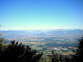 Thoiry in the foreground, with Geneva, Annemasse and the Alps in the background | ||
| ||
 Thoiry Location within Auvergne-Rhône-Alpes region  Thoiry | ||
| Coordinates: 46°14′14″N 5°58′50″E / 46.2372°N 5.9806°ECoordinates: 46°14′14″N 5°58′50″E / 46.2372°N 5.9806°E | ||
| Country | France | |
| Region | Auvergne-Rhône-Alpes | |
| Department | Ain | |
| Arrondissement | Gex | |
| Canton | Thoiry | |
| Intercommunality | Pays de Gex | |
| Government | ||
| • Mayor (2014–2020) | Muriel Bénier | |
| Area1 | 28.93 km2 (11.17 sq mi) | |
| Population (2012)2 | 5,733 | |
| • Density | 200/km2 (510/sq mi) | |
| Time zone | UTC+1 (CET) | |
| • Summer (DST) | UTC+2 (CEST) | |
| INSEE/Postal code | 01419 /01710 | |
| Elevation | 400–1,704 m (1,312–5,591 ft) | |
|
1 French Land Register data, which excludes lakes, ponds, glaciers > 1 km2 (0.386 sq mi or 247 acres) and river estuaries. 2 Population without double counting: residents of multiple communes (e.g., students and military personnel) only counted once. | ||
_mod%C3%A8rne.svg.png)
Thoiry is a commune in the Ain department in eastern France.
The little village was the scene of the September 1926 meeting between Aristide Briand of France and Gustav Stresemann of Germany. During the meeting the two discussed proposals for finally settling the various claims from the First World War, and their common interest in the then-fashionable paneuropean ideas. Ultimately, however, the meeting came to be a missed chance on the road to European integration, as neither statesman could carry domestic opinion with them on these issues.
Population
| Historical population | ||
|---|---|---|
| Year | Pop. | ±% |
| 1793 | 1,114 | — |
| 1800 | 1,178 | +5.7% |
| 1806 | 1,101 | −6.5% |
| 1821 | 1,183 | +7.4% |
| 1831 | 1,290 | +9.0% |
| 1836 | 1,435 | +11.2% |
| 1841 | 1,443 | +0.6% |
| 1846 | 1,499 | +3.9% |
| 1851 | 1,408 | −6.1% |
| 1856 | 1,423 | +1.1% |
| 1861 | 1,460 | +2.6% |
| 1866 | 1,423 | −2.5% |
| 1872 | 1,393 | −2.1% |
| 1876 | 1,356 | −2.7% |
| 1881 | 1,319 | −2.7% |
| 1886 | 1,295 | −1.8% |
| 1891 | 1,349 | +4.2% |
| 1896 | 1,356 | +0.5% |
| 1901 | 1,290 | −4.9% |
| 1906 | 1,280 | −0.8% |
| 1911 | 1,202 | −6.1% |
| 1921 | 1,013 | −15.7% |
| 1926 | 1,076 | +6.2% |
| 1931 | 1,063 | −1.2% |
| 1936 | 1,077 | +1.3% |
| 1946 | 987 | −8.4% |
| 1954 | 1,091 | +10.5% |
| 1962 | 1,130 | +3.6% |
| 1968 | 1,438 | +27.3% |
| 1975 | 1,859 | +29.3% |
| 1982 | 2,112 | +13.6% |
| 1990 | 3,015 | +42.8% |
| 1999 | 4,063 | +34.8% |
| 2008 | 4,938 | +21.5% |
| 2012 | 5,733 | +16.1% |
See also
References
| Wikimedia Commons has media related to Thoiry, Ain. |
This article is issued from
Wikipedia.
The text is licensed under Creative Commons - Attribution - Sharealike.
Additional terms may apply for the media files.