Mapun
| Mapun | |
|---|---|
| Municipality | |
| Municipality of Mapun | |
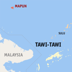 Map of Tawi-Tawi with Mapun highlighted | |
.svg.png) Mapun Location within the Philippines | |
| Coordinates: 7°00′N 118°30′E / 7°N 118.5°ECoordinates: 7°00′N 118°30′E / 7°N 118.5°E | |
| Country |
|
| Region | Autonomous Region in Muslim Mindanao (ARMM) |
| Province | Tawi-Tawi |
| District | Lone District |
| Barangays | 15 (see Barangays) |
| Government [1] | |
| • Type | Sangguniang Bayan |
| • Mayor | Kennedy Muksin |
| • Electorate | 15,250 voters (2016) |
| Area [2] | |
| • Total | 181.29 km2 (70.00 sq mi) |
| Population (2015 census)[3] | |
| • Total | 26,597 |
| • Density | 150/km2 (380/sq mi) |
| Time zone | UTC+8 (PST) |
| ZIP code | 7508 |
| PSGC | 157003000 |
| IDD : area code | +63 (0)68 |
| Climate type | Tropical climate |
| Income class | 4th municipal income class |
| Revenue (₱) | 78,110,586.46 (2016) |
| Native languages |
Sama language Tagalog |
Mapun, officially the Municipality of Mapun, is a 4th class municipality in the province of Tawi-Tawi, Philippines. According to the 2015 census, it has a population of 26,597 people.[3]
It is formerly known as Cagayan de Tawi-Tawi and prior to that as Cagayan de Sulu.
Mapun is an island municipality in the Sulu Sea[4] on the south-western extreme of the Philippines, located very close to Sabah, Malaysia. The people inhabiting the island are known as Jama Mapun or "people of Mapun". Their dialect is Pullun Mapun, which means "Mapun dialect".
Due to an administrative error in the Treaty of Paris, while the remainder of the Philippines was ceded to the United States, Sibutu and Cagayan de Sulu were retained under Spanish Sovereignty until they were formally ceded to the United States upon the ratification of the Treaty of Washington on March 23, 1901.
Barangays
Mapun is politically subdivided into 15 barangays.
- Boki
- Duhul Batu
- Guppah
- Iruk-Iruk
- Kompang
- Liyubud (Poblacion)
- Lubbak Parang
- Lupa Pula
- Mahalu
- Pawan
- Sapah
- Sikub
- Tabulian
- Tanduan
- Umus Mataha
Demographics
| Population census of Mapun | ||
|---|---|---|
| Year | Pop. | ±% p.a. |
| 1903 | 2,000 | — |
| 1918 | 6,090 | +7.71% |
| 1939 | 6,851 | +0.56% |
| 1948 | 8,824 | +2.85% |
| 1960 | 10,789 | +1.69% |
| 1970 | 12,577 | +1.54% |
| 1975 | 15,892 | +4.80% |
| 1980 | 19,607 | +4.29% |
| 1990 | 19,372 | −0.12% |
| 1995 | 20,716 | +1.26% |
| 2000 | 22,011 | +1.31% |
| 2007 | 29,801 | +4.27% |
| 2010 | 24,168 | −7.34% |
| 2015 | 26,597 | +1.84% |
| Source: Philippine Statistics Authority[3][5][6][7] | ||
Education
- Elementary
- Lupa Pula Pilot School (formerly Lupa Pula Central School) - elementary pupils are primarily from Lupa Pula, Liyubud, and Mahalu.
- Mahalu Elementary School
- Duhul Batu Elementary School
- Sikub Elementary School
- Tabulian Elementary School
- Sapah Elementary School
- Boki Elementary School
- Kompang Elementary School
- Tanduan Elementary School
- Pawan Elementary School
- Guppah Elementary School
- Iruk-Iruk Elementary School
- Umus Mataha Elementary School
- Lubbak Parang Elementary School
- Imam Saat Elementary School
- Secondary
- Notre Dame of Cagayan (NDC) - a private school located in the border of Barangay Lupa Pula and Barangay Mahalu.
- Mindanao State University (MSU) - a public school located in Mahalu
- Tawi-Tawi Academy (TTA) - a private school located in Barangay Guppah
- Tertiary
Mindanao State University Extension - a public school and the only college institution in Mapun. MSU-Extension offers two-year courses.
Majority of those who graduate from high school pursue their studies in other places, most notably Zamboanga City, Palawan, and Bongao.
Mapun Day
Mapun Foundation Day is celebrated by the Jama Mapun every September 5. This week-long celebration starts on September 1, with a parade and then a short program held in Lupa Pula Central School. Various competitions are held during Mapun Day, which includes singing competitions (in English, Tagalog, and Pullun Mapun), dance showdowns (modern dance, folk dance, pangalay, which is a native dance, and lunsay, which is a dance performed during weddings), Azaan competition, Tarasul iban Daman (Mapun's version of declamation and oration), and Leleng, to name a few. Each Barangay has their own representatives in the various events. However, the most popular is the "Budjang Mapun", which is a beauty contest. Each barangay has its own contestant in this event. The winner of the search for "Budjang Mapun" is usually sent to Bongao as Mapun's representative in Budjang Tawi-Tawi, a similar beauty search held in Bongao every Province Day. Every municipality in Tawi-Tawi has its own contestant.
Local legend
According to local legend the Berbalang is indigenous to a small village in the interior of the Island.
See also
References
- ↑ "Municipality". Quezon City, Philippines: Department of the Interior and Local Government. Retrieved 31 May 2013.
- ↑ "Province: Tawi-tawi". PSGC Interactive. Quezon City, Philippines: Philippine Statistics Authority. Retrieved 12 November 2016.
- 1 2 3 Census of Population (2015). "ARMM – Autonomous Region in Muslim Mindanao". Total Population by Province, City, Municipality and Barangay. PSA. Retrieved 20 June 2016.
- ↑ C.Michael Hogan. 2011. Sulu Sea. Encyclopedia of Earth. Eds. P.Saundry & C.J.Cleveland. Washington DC
- ↑ Census of Population and Housing (2010). "ARMM – Autonomous Region in Muslim Mindanao". Total Population by Province, City, Municipality and Barangay. NSO. Retrieved 29 June 2016.
- ↑ Censuses of Population (1903–2007). "ARMM – Autonomous Region in Muslim Mindanao". Table 1. Population Enumerated in Various Censuses by Province/Highly Urbanized City: 1903 to 2007. NSO.
- ↑ "Province of Tawi‑tawi". Municipality Population Data. Local Water Utilities Administration Research Division. Retrieved 17 December 2016.
External links
Bongao (capital) | |
| Municipalities | |