Panampangan Island
 Panampangan Island | |
.svg.png) Panampangan Island Location within the Philippines | |
| Geography | |
|---|---|
| Coordinates | 5°3′42″N 120°4′24″E / 5.06167°N 120.07333°ECoordinates: 5°3′42″N 120°4′24″E / 5.06167°N 120.07333°E[1] |
| Archipelago | Sulu Archipelago |
| Adjacent bodies of water | Celebes Sea |
| Area | 0.1 km2 (0.039 sq mi)[2] |
| Administration | |
| Region | Autonomous Region in Muslim Mindanao |
| Province | Tawi-Tawi |
| Municipality | Sapa-Sapa |
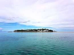
Panampangan Island is an island in the municipality of Sapa-Sapa, Tawi-Tawi. With an area of 0.1 square kilometres (0.039 sq mi)[2]. It is located inside Basibuli Shoal[1], to which its sandbar extends to 3,128.37 metres (10,263.7 ft).[2] It is considered as the longest sandbar in the Philippines[3][1] and is characterized with fine white sand beach[4] in the Sulu Archipelago.
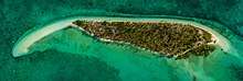
Aerial Map View of Panampangan Island
See also
References
- 1 2 3 Malicdem, Ervin (28 June 2017). "Panampangan Island as the longest sandbar of the Philippines". Schadow1 Expeditions: 4. doi:10.13140/RG.2.2.10426.49604. Retrieved 5 November 2017.
- 1 2 3 Malicdem, Ervin (28 June 2017). "Panampangan Island, the Beach and the Longest Sandbar in the Philippines". Schadow1 Expeditions. Retrieved 15 September 2017.
- ↑ Malicdem, Ervin (12 July 2017). "10 Longest Sandbars in the Philippines". Schadow1 Expeditions. Retrieved 15 September 2017.
- ↑ De Jesus, Diovanie (6 August 2016). "Diving into the Pristine Blue Waters of Tawi-Tawi". GMA News Online. Retrieved 15 September 2017.
External links
| Wikimedia Commons has media related to Panampangan Island. |
This article is issued from
Wikipedia.
The text is licensed under Creative Commons - Attribution - Sharealike.
Additional terms may apply for the media files.