State College, Pennsylvania
| State College Borough of State College | |
|---|---|
|
Borough home rule municipality | |
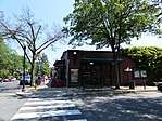 _near_White_Course_Drive_in_State_College%2C_Pennsylvania.jpg) _near_Allen_Street_in_State_College%2C_Pennsylvania.jpg) _(Pennsylvania_Route_26)_near_Locust_Lane_in_State_College%2C_Pennsylvania.jpg) Images from top to bottom, left to right (1) Downtown, (2) Campus building spanning across Atherton Street at White Course, (3) Beaver Avenue near Allen Street, (4) "Beaver Canyon" on Beaver Avenue | |
| Nickname(s): Lion Country | |
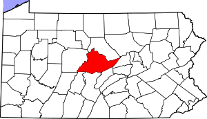
 Location of State College in Centre County, Pennsylvania. | |
 State College Location in Pennsylvania and the United States  State College State College (the US) | |
| Coordinates: 40°47′29″N 77°51′31″W / 40.79139°N 77.85861°WCoordinates: 40°47′29″N 77°51′31″W / 40.79139°N 77.85861°W | |
| Country | United States |
| State | Pennsylvania |
| County | Centre |
| Incorporated | August 29, 1896 |
| Government | |
| • Mayor | Don Hahn |
| Area[1] | |
| • Borough home rule municipality | 4.56 sq mi (11.80 km2) |
| • Land | 4.56 sq mi (11.80 km2) |
| • Water | 0.00 sq mi (0.00 km2) |
| Elevation | 1,154 ft (352 m) |
| Population (2010)[2] | |
| • Borough home rule municipality | 42,034 |
| • Estimate (2016)[3] | 41,992 |
| • Density | 9,216.86/sq mi (3,558.34/km2) |
| • Urban | 87,454 (US: 335th) |
| • Metro |
MSA:158,742 (US: 257th) CSA: 236,577 (US: 124th) |
| Time zone | UTC−5 (EST) |
| • Summer (DST) | UTC−4 (EDT) |
| Zip | 16801, 16802, 16803, 16804, 16805 |
| Area code | 814 |
| FIPS code | 42-73808 |
| School district | State College Area School District |
| Website | Borough of State College |
State College is a home rule municipality in Centre County in the Commonwealth of Pennsylvania. It is the largest designated borough in Pennsylvania.[4] It is the principal borough of the six municipalities that make up the State College area, the largest settlement in Centre County and one of the principal cities of the greater State College-DuBois Combined Statistical Area with a combined population of 236,577 as of the 2010 United States Census. In the 2010 census, the borough population was 42,034 with approximately 105,000 living in the borough plus the surrounding townships often referred to locally as the "Centre Region." Many of these Centre Region communities also carry a "State College, PA" address although are not part of the borough of State College.[4]
State College is a college town, dominated economically and demographically by the presence of the University Park campus of the Pennsylvania State University (Penn State). Lion Country is another used term to refer to the State College area, the term also includes the borough and the townships of College, Harris, Patton, and Ferguson.
In 2013, State College was ranked as the third-safest metropolitan area in the United States by the CQ Press.[5]
History

State College evolved from a village to a town in order to serve the needs of the Pennsylvania State College, founded as the Farmers' High School of Pennsylvania in 1855. State College was incorporated as a borough on August 29, 1896, and has grown with the college, which was renamed The Pennsylvania State University in 1953.
In 1973 State College adopted a home rule charter which took effect in 1976;[6] since then, it has not been governed by the state's Borough Code, although it retains "Borough of State College" as its official name.
The university has a post office address of University Park, Pennsylvania. When Penn State changed its name from College to University in 1953, its president, Milton S. Eisenhower, sought to persuade the town to change its name as well.[7] A referendum failed to yield a majority for any of the choices for a new name, and so the town remains State College. After this, Penn State requested a new name for its on-campus post office in the HUB-Robeson Center from the U.S. Post Office Department. The post office, which has since moved across an alley to the McAllister Building, is the official home of ZIP code 16802 (University Park).
Geography
Location
State College is situated at an elevation of approximately 1,200 feet (370 m) above sea level.[8] According to the United States Census Bureau, the borough has a total area of 4.5 square miles (12 km2), all of it land. It is surrounded by large tracts of farmland, and an expanse of Appalachian Mountain ranges and forests. Nittany Mountain is part of Pennsylvania's geologic ridge-and-valley province of the Appalachian Mountains.[9] It is (approximately) the geographic center of Pennsylvania, and as a result, Penn State University was founded in State College.
Climate
State College has a humid continental climate (Köppen Dfa). Temperatures average 27.2 °F (−2.7 °C) in January and 72.1 °F (22.3 °C) in July. Annual precipitation averages 39.8 inches (101 cm), with 45.9 inches (117 cm) of annual snowfall on average.[10] With a period of record dating back to 1893, the lowest temperature recorded was −20 °F (−29 °C) on February 10, 1899 and the highest was 102 °F (39 °C) on July 17, 1988, and July 9, 1936.
| Climate data for State College, Pennsylvania (1981–2010 normals) | |||||||||||||
|---|---|---|---|---|---|---|---|---|---|---|---|---|---|
| Month | Jan | Feb | Mar | Apr | May | Jun | Jul | Aug | Sep | Oct | Nov | Dec | Year |
| Record high °F (°C) | 71 (22) |
73 (23) |
86 (30) |
94 (34) |
93 (34) |
96 (36) |
102 (39) |
101 (38) |
98 (37) |
90 (32) |
81 (27) |
71 (22) |
102 (39) |
| Average high °F (°C) | 34.2 (1.2) |
37.5 (3.1) |
46.4 (8) |
59.8 (15.4) |
69.7 (20.9) |
77.9 (25.5) |
81.6 (27.6) |
80.2 (26.8) |
72.3 (22.4) |
61.2 (16.2) |
49.8 (9.9) |
38.1 (3.4) |
59.1 (15.1) |
| Average low °F (°C) | 20.2 (−6.6) |
21.7 (−5.7) |
28.2 (−2.1) |
39.3 (4.1) |
49.3 (9.6) |
58.7 (14.8) |
62.6 (17) |
61.0 (16.1) |
53.1 (11.7) |
42.1 (5.6) |
33.9 (1.1) |
24.8 (−4) |
41.2 (5.1) |
| Record low °F (°C) | −18 (−28) |
−20 (−29) |
−9 (−23) |
1 (−17) |
27 (−3) |
30 (−1) |
40 (4) |
30 (−1) |
28 (−2) |
16 (−9) |
1 (−17) |
−13 (−25) |
−20 (−29) |
| Average precipitation inches (mm) | 2.74 (69.6) |
2.53 (64.3) |
3.41 (86.6) |
3.20 (81.3) |
3.45 (87.6) |
4.10 (104.1) |
3.52 (89.4) |
3.84 (97.5) |
3.65 (92.7) |
3.09 (78.5) |
3.35 (85.1) |
2.88 (73.2) |
39.77 (1,010.2) |
| Average snowfall inches (cm) | 12.7 (32.3) |
11.0 (27.9) |
10.2 (25.9) |
1.4 (3.6) |
0 (0) |
0 (0) |
0 (0) |
0 (0) |
0 (0) |
.3 (0.8) |
2.2 (5.6) |
7.7 (19.6) |
45.6 (115.8) |
| Average precipitation days (≥ 0.01 in) | 12.8 | 11.2 | 11.8 | 13.1 | 14.0 | 12.5 | 11.9 | 10.6 | 10.6 | 11.1 | 11.5 | 12.8 | 143.8 |
| Average snowy days (≥ 0.1 in) | 8.4 | 7.2 | 4.5 | 1.5 | 0 | 0 | 0 | 0 | 0 | .2 | 1.8 | 6.2 | 29.8 |
| Source: NOAA (extremes 1896–present),[11] | |||||||||||||
Demographics
| Historical population | |||
|---|---|---|---|
| Census | Pop. | %± | |
| 1900 | 851 | — | |
| 1910 | 1,425 | 67.5% | |
| 1920 | 2,405 | 68.8% | |
| 1930 | 4,450 | 85.0% | |
| 1940 | 6,226 | 39.9% | |
| 1950 | 17,227 | 176.7% | |
| 1960 | 22,409 | 30.1% | |
| 1970 | 32,833 | 46.5% | |
| 1980 | 36,130 | 10.0% | |
| 1990 | 38,923 | 7.7% | |
| 2000 | 38,420 | −1.3% | |
| 2010 | 42,034 | 9.4% | |
| Est. 2016 | 41,992 | [3] | −0.1% |
| Sources:[12][13][14][15] | |||
According to the 2010 census,[15] there are 42,034 people, 12,610 households, and 3,069 families residing in the borough. The population density was 9,258.6 people per square mile (3,574.3/km²). There were 13,007 housing units at an average density of 2,865.0 per square mile (1,106.0/km²). The racial makeup of the borough was 83.2% White, 3.8% Black or African American, 0.2% Native American, 9.8% Asian, 1.0% Other, and 2.0% from two or more races. 3.9% of the population were of Hispanic or Latino ancestry. 22,681 or 54.0% of borough residents were males and 19,353 or 46.0% were females.
A 2014 estimate had the racial makeup of the borough as 78.9% Non-Hispanic White, 5.6% Black or African American, 0.5% Native American and Alaska Native, 11.5% Asian, 0.1% Native Hawaiian and other Pacific Islander, 0.8% Some other race, and 2.2% two or more races. 4.4% were Hispanic or Latino (of any race).[16]
Of the 12,610 households, 9.1% had children under the age of 18 living with them, 18.2% were married couples living together, 3.8% had a female householder with no husband present, 2.4% had a male householder with no wife present, and 75.6% were non-families. 33.6% of all households were made up of individuals and 5.1% had someone living alone who was 65 years of age or older. The average household size was 2.30 and the average family size was 2.71.
The age distribution of the borough, overwhelmingly influenced by its student population, was 5.1% under the age of 18, 70.6% from 18 to 24, 13.1% from 25 to 44, 6.5% from 45 to 64, and 4.7% who were 65 years of age or older. The median age was 22 years.
The median income for a household in the borough was $23,513, and the median income for a family was $58,953. The per capita income for the borough was $13,336. 46.9% of the population and 9.8% of families are below the poverty line. Out of the total population, 10.6% of those under the age of 18 and 2.2% of those 65 and older are living below the poverty line. However, traditional measures of income and poverty can be very misleading when applied to a community like State College which is dominated by students.
The population of the State College Metropolitan Statistical Area was 153,990 in the 2010 U.S. census.
Economy
Pennsylvania State University is the largest single employer in the region, employing over 26,000 full- and part-time workers in 2015. In addition to higher education, other industries in the area include health care, retail, hospitality services, construction, and government.[17]
| # | Employer | # of employees |
|---|---|---|
| 1 | Pennsylvania State University | 26,353 |
| 2 | Mount Nittany Medical Center | 2,289 |
| 3 | Government of Pennsylvania | 1,697 |
| 4 | State College Area School District | 1,203 |
| 5 | Walmart | 723 |
| 6 | Glenn O. Hawbaker Inc. (construction) | 700 |
| 7 | Weis Markets | 656 |
| 8 | Centre County Government | 597 |
| 9 | Geisinger Medical Group | 545 |
| 10 | HRI Inc. (asphalt contractor) | 490 |
Other notable employers include the Federal Government (448 employees), YMCA (437 employees), Wegmans (420 employees), AccuWeather (370 employees), McDonald's (298 employees), Minitab (279 employees), Giant Food Stores (251 employees), Sheetz (237 employees), Raytheon (228 employees), Darden Restaurants (200 employees), Penn State Hershey Medical Group (190 employees), State College Borough Government (189 employees) and Centre Area Transportation Authority (178 employees).[17]
Arts and culture
Events
The Central Pennsylvania Festival of the Arts,[18] usually referred to as "Arts Fest", is held downtown every July. The five-day festival features artists from around the country and draws more than 125,000 visitors.[19] Streets are closed off and lined with booths where people can buy paintings, pottery, jewelry, and other hand-made goods. There are also numerous musical performances and plays to take in, and food vendors selling everything from funnel cakes to Indian cuisine.
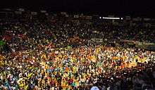
The Penn State IFC/Panhellenic Dance Marathon, commonly referred to as THON, is a 46-hour Dance Marathon that takes place every February on the University Park campus with the purpose of raising money for the Four Diamonds Foundation.[20] A number of events throughout the year pave the way to February's THON weekend.
Blue-White Football Weekend occurs in April and includes a carnival, fireworks, food vendors, the student entertainment stage, live music, a parade, and more.[21] On game day, an autograph session with the football student-athletes is held in Beaver Stadium, prior to kickoff of the Blue-White football intrasquad scrimmage game.
Some of the other popular annual events in the area include "First Night State College", a New Year's Eve celebration with carved ice sculptures and musical performances that takes place in downtown State College and "Central PA 4th Fest", a day-long event which includes Fourth of July fireworks, crafts, food vendors and entertainers.
On Saturday February 4, 2017, State College became a Guinness World Record holder. Light Up State College organized 5,226 lighted ice luminaries that were displayed across South Allen Street in downtown State College. This is the most ice luminaries in any one location to date. The previous record was held by Vuollerim, Sweden, with 2,652 ice luminaries.
Sports
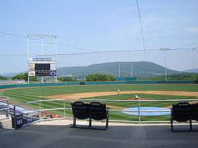
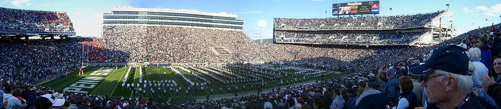
State College is most known for Penn State Nittany Lions football which draws over 100,000 fans to Beaver Stadium on home games.[22] The borough itself is home to the State College Spikes, a minor league baseball team. The team is part of the New York–Penn League and has played in Medlar Field at Lubrano Park, also home to Penn State baseball, since 2006.
| Sport | League | Club | Founded | Venue | League championships | Championship years |
|---|---|---|---|---|---|---|
| Baseball | NYPL | State College Spikes | 2006 | Medlar Field at Lubrano Park | 2 | 2014, 2016 |
| Basketball | NCAA | Penn State Nittany Lions Men's Basketball | 1897 | Bryce Jordan Center | 0 | N/A |
| Basketball | NCAA | Penn State Lady Lion's Women's Basketball | 1965 | Bryce Jordan Center | 0 | N/A |
| Football | NCAA | Penn State Nittany Lions football | 1887 | Beaver Stadium | 2 | 1982, 1986 |
| Ice Hockey | NCAA | Penn State Nittany Lions men's ice hockey | 1939 | Pegula Ice Arena | 0 | N/A |
| Ice hockey | NCAA | Penn State Nittany Lions women's ice hockey | 1996 | Pegula Ice Arena | 0 | N/A |
| Soccer | NCAA | Penn State Nittany Lions men's soccer | 1911 | Jeffrey Field | 0 | N/A |
| Soccer | NCAA | Penn State Nittany Lions Women's Soccer | 1994 | Jeffrey Field | 1 | 2015 |
| Volleyball | NCAA | Penn State Nittany Lions men's volleyball | 1976 | Rec Hall | 2 | 1994, 2008 |
| Volleyball | NCAA | Penn State Nittany Lions women's volleyball | 1976 | Rec Hall | 7 | 1999, 2007, 2008, 2009, 2010, 2013, 2014 |
| Wrestling | NCAA | Penn State Nittany Lions Wrestling | 1909 | Rec Hall | 9 | 1921, 1953, 2011, 2012, 2013, 2014, 2016, 2017, 2018 |
Jeffery Field
Jeffrey Field is a soccer specific stadium in State College, Pennsylvania that is home to both the Penn State Nittany Lions women's soccer and Penn State Nittany Lions men's soccer programs.[23] Address is University Drive at East Park Avenue.[24]
Rec Hall
Rec Hall is a field house located on the University Park campus of the Pennsylvania State University. It was opened on January 15, 1929, and is still in use. It is home to the Penn State Nittany Lions women's and men's volleyball teams, and Penn State Nittany Lions wrestling. Rec Hall has a banked indoor track that of approximately 257 yards around or roughly 6.85 laps/mile.
Pegula Ice Arena
The Pegula Ice Arena is a 6,014-seat multi-purpose arena in University Park, Pennsylvania on the campus of Penn State University, opened in October 11, 2013 it replaced the 1,350-seat Penn State Ice Pavilion. The facility is located on the corner of Curtin Road and University Drive near the Bryce Jordan Center.
Beaver Stadium
Beaver Stadium is an outdoor college football stadium in University Park, Pennsylvania, United States, on the campus of Pennsylvania State University. It is home to the Penn State Nittany Lions of the Big Ten Conference since 1960. Beaver Stadium has an official seating capacity of 106,572, making it currently the second largest stadium in the Western Hemisphere and the third largest in the world.
Rothrock State Forest
Rothrock State Forest: The Mount Nittany Bicycling Association (NMBA) is active at maintaining and adding trails through the local state forest. There are miles of trails through Rothrock State Forest most of which are challenging and not for beginners. There are many access points and many people find the Purple Lizard Maps to be helpful until they know the area well.
Government
Federal
At the federal level, State College forms part of Pennsylvania's 5th congressional district. The current representative is Glenn "G.T." Thompson.
State
Jake Corman represents Pennsylvania Senate, District 34, and Scott Conklin represents Pennsylvania House of Representatives, District 77.
County
At the county level, Centre County, Pennsylvania's county seat is in Bellefonte, Pennsylvania. There are three county-level district courts within State College, with the others being Philipsburg, Bellefonte, and Centre Hall.
The current county-level districts are divided as follows, all of which are common pleas courts. The jurisdictions include civil claims and summary offenses. Higher level courts are located in neighboring Bellefonte.[25]
- District 49-1-01, District Judge Carmine W. Prestia
- District 49-2-01, District Judge Casey McClain
- District 49-3-02, District Judge Kelley Gillette-Walker
- District 49-3-03, District Judge Allen Sinclair
- District 49-3-04, District Judge Thomas Jordan
- District 49-3-05, District Judge Steven F. Lachman
Regional
The Borough of State College is a member of the Centre Region Council of Governments (CRCOG).[26] Other members are
Local
At the local level, the Borough of State College[27] government is currently run by the following elected officials:[28]
- Mayor: Don Hahn
- President of Council: Thomas E. Daubert
- Council members:
- Jesse L. Barlow
- David J. Brown
- Catherine G. Dauler
- Janet P. Engeman
- Theresa D. Lafer
- Evan A. Myers
Education
Public schools
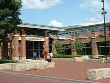
State College is served by the State College Area School District which operates nine elementary schools, two middle schools, and one high school in and around State College.[29]
Charter schools
Private schools
- Children's House Montessori School
- The Goddard School[36]
- Grace Prep High School[37]
- Kinder Station
- Nittany Christian School[38]
- Our Children's Center Montessori School[39]
- Our Lady of Victory Catholic School[40]
- Park Forest Montessori School[41]
- St. John Catholic School[42]
- Saint Joseph's Catholic Academy[43]
- State College Friends School[44]
Higher and post-secondary education
- Penn State University is located partially in the borough of State College.
- South Hills School of Business & Technology[45]
Libraries
State College is served by the following libraries:[46]
- American Philatelic Research Library
- Centre County Library & Historical Museum
- Centre County Library Bookmobile
- Centre Hall Area Branch Library
- Holt Memorial Library (Philipsburg)
- Pennsylvania State University Libraries
- Davey Library (physical and mathematical sciences)
- Deike Library (earth and mineral sciences)
- Hammond Library (engineering)
- Pattee and Paterno Libraries (main library)
- Pollock Library (study library)
- Stuckeman Library (architecture and landscape architecture)
- Schlow Centre Region Library
Media
State College's daily newspaper is the Centre Daily Times, part of the McClatchy Company chain. There is also a weekly version published as Centre Weekly. An alternative town newspaper is the Centre County Gazette[47] Newspapers of Pennsylvania State University's main campus include The Forum, the student-run Daily Collegian, and Onward State, a student-run digital media blog.[48]
Numerous magazines are also published in State College including State College Magazine,[49] Blue White Illustrated,[50] Centered Magazine,[51] Pennsylvania Business Central,[52] Town & Gown,[53] Valley Magazine,[54] and Voices of Central Pennsylvania.[55]
The State College radio market is ranked #249 in the nation. Some of the more popular stations include WAPY, WBHV, WBUS, WFGE, WKPS, WMAJ, WPSU, WQCK, WQWK, WRSC, and WZWW.
State College is part of the Johnstown/Altoona/State College television market, which is ranked #102 in the nation.[56] Television stations broadcasting out of State College include WPSU 3 (PBS) and WHVL 29 (MyNetworkTV) as well as C-NET, Centre County's Government and Education Access Television Network, which broadcasts on two channels: CGTV (Government Access TV) and CETV (Educational Access TV). Starting in late 2016, WATM-TV 23 (ABC) started producing a Centre County focused newscast, anchored from a studio on West College Avenue. WJAC-TV 6 (NBC), WTAJ-TV 10 (CBS), and WWCP-TV 8 (FOX) also maintain satellite studios and offices here.
Infrastructure
_in_College_Township%2C_Pennsylvania.jpg)
Health care
- HealthSouth Nittany Valley Rehabilitation Hospital
- Mount Nittany Medical Center
Transportation
In 2009, the State College metropolitan statistical area (MSA) ranked as the tenth highest in the United States for percentage of commuters who walked to work (8 percent).[57] In 2013, the State College MSA ranked as the fifteenth lowest in the United States for percentage of workers who commuted by private automobile (79.2 percent). During the same year, 9.9 percent of State College area commuters walked to work.[58]
The borough is served by the Centre Area Transportation Authority through bus services and the University Park Airport for commercial air traffic.
Notable people
The following individuals were born and/or raised in State College:
|
Sport figures:
|
Others:
|
The following were/are residents of State College:
|
Sport figures:
|
Others:
|
See also
References
- ↑ "2016 U.S. Gazetteer Files". United States Census Bureau. Retrieved Aug 13, 2017.
- ↑ "American FactFinder". United States Census Bureau. Retrieved 2014-08-06.
- 1 2 "Population and Housing Unit Estimates". Retrieved June 9, 2017.
- 1 2 "State College: Mayor's Welcome".
- ↑ CQ Press 2013 Metropolitan Crime Rate Rankings SAGE Publications
- ↑ Pennsylvania Code Title 314, Sec. 41.1-101 et seq. Archived December 1, 2005, at the Wayback Machine.
- ↑ "Quest for National Recognition". Penn State University Libraries. 2016-09-15. Retrieved 2018-09-21.
- ↑ "US Gazetteer files: 2010, 2000, and 1990". United States Census Bureau. 2011-02-12. Retrieved 2011-04-23.
- ↑ "Pennsylvania State University - Nittany Mountain". www.psu.edu.
- ↑ Service, US Department of Commerce, NOAA, National Weather. "Normal Snowfall in Central PA". www.weather.gov. Retrieved 2015-12-14.
- ↑ "Pennsylvania State Climatologist – State College Extremes". Pennsylvania State Climatonogist. Retrieved 2013-04-28.
- ↑ "Population Estimates". United States Census Bureau. Retrieved 2014-08-06.
- ↑ "Number of Inhabitants: Pennsylvania" (PDF). 18th Census of the United States. U.S. Census Bureau. Retrieved 22 November 2013.
- ↑ "Pennsylvania: Population and Housing Unit Counts" (PDF). U.S. Census Bureau. Retrieved 22 November 2013.
- 1 2 "American FactFinder". United States Census Bureau. Archived from the original on 2013-09-11. Retrieved 2008-01-31.
- ↑ Bureau, U.S. Census. "American FactFinder - Results". factfinder.census.gov.
- 1 2 "The top 40 employers in Centre County".
- ↑ "Home - Central Pennsylvania Festival of the Arts". www.arts-festival.com.
- ↑ "Home - Central Pennsylvania Festival of the Arts". arts-festival.com.
- ↑ "Fighting Pediatric Cancer". Penn State Hershey. Retrieved 3 August 2012.
- ↑ "Penn State Blue-White Game Weekend 2013". LazerPro Digital Media Group. Retrieved 3 August 2012.
- ↑ "Beaver Stadium Attendance Up 5,000 Per Game in 2014 - Onward State". 2 December 2014.
- ↑ "GOPSUSPORTS.com :: Official Athletic Site of Penn State". Gosusports.com. Retrieved 9 June 2016.
- ↑ "Jeffrey Field". Foursquare.com. Retrieved 9 June 2016.
- ↑ Centre County Government: District Judges. Co.centre.pa.us. Retrieved on 2011-03-30.
- ↑ "COG - Council of Governments". www.crcog.net.
- ↑ "Borough of State College Government - Official Website". www.statecollegepa.us.
- ↑ Council Member Directory | Borough of State College Government statecollegepa.us
- ↑ State College Area School District. Scasd.org. Retrieved on 2011-03-30.
- ↑ "Home". CLC Charter School.
- ↑ "Nittany Valley Charter School". Nittany Valley Charter School.
- ↑ Although not officially a charter school, SCASD refers to it as one.
- ↑ "Delta Program High School / The Delta Program".
- ↑ Wonderland Charter School
- ↑ "YSCP Charter School – YSCP Charter School". www.yscp.org.
- ↑ "The Goddard School - Private Preschool & Educational Daycare". www.goddardschool.com.
- ↑ Grace Prep High School : An Innovative, Award-winning School of Academic Excellence. Graceprep.com (2010-05-26). Retrieved on 2011-03-30.
- ↑ Nittany Christian School. Nittanychristian.com (2006-10-02). Retrieved on 2011-03-30.
- ↑ "Our Children's Center - A Montessori Preschool - Downtown State College Pennsylvania". www.occmontessori.org.
- ↑ "Our Lady of Victory Catholic School K-8 / Overview". www.olvcatholicschool.org.
- ↑ "Park Forest Montessori School: Quality preschool and kindergarten in State College, Pennsylvania". www.parkforestmontessori.com.
- ↑ "Faith. Service. Academics". St. John the Evangelist Catholic School.
- ↑ "Home". 12 June 2018.
- ↑ State College Friends School. State College Friends School. Retrieved on 2011-03-30.
- ↑ "Home". South Hills School of Business & Technology.
- ↑ Libraries. Statecollege.com. Retrieved on 2011-03-30.
- ↑ "State College, PA - Centre County Gazette - Reporting Centre County". www.statecollege.com.
- ↑ "Pennsylvania Newspapers". NewsLink. Retrieved March 20, 2011.
- ↑ State College Magazine, Pennsylvania Archived January 2, 2016, at the Wayback Machine.. State College Magazine (2011-03-01). Retrieved on 2011-03-30.
- ↑ Blue White Illustrated Blue White Illustrated
- ↑ Centered Magazine Centered Magazine
- ↑ Pennsylvania Business Central Pennsylvania Business Central
- ↑ Town & Gown Town & Gown
- ↑ Valley Magazine Valley Magazine
- ↑ Voices of Central Pennsylvania Voices of Central Pennsylvania
- ↑ Nielsen | Local Television Market Universe Estimates Archived March 4, 2016, at the Wayback Machine.
- ↑ "Commuting in the United States: 2009" (PDF). American Community Survey Reports. September 2011. Archived from the original (PDF) on 2017-07-26. Retrieved December 26, 2017.
- ↑ McKenzie, Brian (August 2015). "Who Drives to Work? Commuting by Automobile in the United States: 2013" (PDF). American Survey Reports. Retrieved December 26, 2017.
External links
| Wikivoyage has a travel guide for State College. |
- Borough of State College Government website
- StateCollege.com – news and information website
- Centre Daily Times
- Central Pennsylvania Convention & Visitors Bureau
- Chamber of Business & Industry of Centre County
- Downtown State College Improvement District
- Map 536 *Augmented by Wood, C. R. (1980), Summary groundwater resources of Centre County, Pennsylvania, Pennsylvania Geological Survey, 4th ser., Water Resource Report 48, 60 p.