Queen Maud Mountains
| Queen Maud Mountains | |
|---|---|
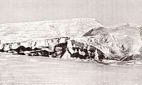 Photo of Mount Fridtjof Nansen in the Queen Maud Mountains taken by Roald Admundsen | |
| Highest point | |
| Peak | Mount Kaplan[1] |
| Elevation | 4,230 m (13,880 ft) |
| Coordinates | 85°45′S 152°7′W / 85.750°S 152.117°WCoordinates: 85°45′S 152°7′W / 85.750°S 152.117°W |
| Geography | |
 Queen Maud Mountains Location of Queen Maud mountains in Antarctica | |
The Queen Maud Mountains are a major group of mountains, ranges and subordinate features of the Transantarctic Mountains, lying between the Beardmore and Reedy Glaciers and including the area from the head of the Ross Ice Shelf to the Antarctic Plateau in Antarctica. Captain Roald Amundsen and his South Pole party ascended Axel Heiberg Glacier near the central part of this group in November 1911, naming these mountains for the Norwegian queen Maud of Wales.[2] Despite the name, they are not located within Queen Maud Land.
Elevations bordering the Beardmore Glacier, at the western extremity of these mountains, were observed by the British expeditions led by Ernest Shackleton (1907–09) and Robert Falcon Scott (1910-13), but the mountains as a whole were mapped by several American expeditions led by Richard Evelyn Byrd (1930s and 1940s), and United States Antarctic Program (USARP) and New Zealand Antarctic Research Program (NZARP) expeditions from the 1950s through the 1970s.[2]
Features
Geographical features include:
Barton Mountains
Bush Mountains
Commonwealth Range
- Airdrop Peak
- Beardmore Glacier
- Beetle Spur
- Celebration Pass
- Dolphin Spur
- Ebony Ridge
- Flat Top
- Hood Glacier
- Keltie Glacier
- Lands End Nunataks
- Ludeman Glacier
- Mount Cyril
- Mount Donaldson
- Mount Henry
- Mount Kathleen
- Mount Kyffin
- Mount Patrick
- Mount Robert Scott
- Osicki Glacier
- Pain Neve
- Separation Range
- Siege Dome
Dominion Range
Gothic Mountains
Grosvenor Mountains
Hays Mountains
- Cappellari Glacier
- Cox Peaks
- Dragons Lair Névé
- Fission Wall
- Forbidden Valley
- Heinous Peak
- Koerwitz Glacier
- Mount Armstrong
- Mount Astor
- Mount Borcik
- Mount Colbert
- Mount Crockett
- Mount Dayton
- Mount Dietz
- Mount Gevers
- Mount Goodale
- Mount Griffith
- Mount Stump
- Mount Thorne
- Mount Vaughan
- Mount Walshe
- Scott Glacier
- Sledging Col
- Souchez Glacier
- Vaughan Glacier
Herbert Range
Hughes Range
La Gorce Mountains
Prince Olav Mountains
- Allaire Peak
- Barrett Glacier
- Cape Irwyn
- Centennial Peak
- Clark Spur
- Gough Glacier
- Hardiman Peak
- Harwell Glacier
- Holzrichter Glacier
- Jones Peak
- Krout Glacier
- Longhorn Spurs
- McGregor Glacier
- Mercik Peak
- Mount Campbell
- Mount Dodge
- Mount Finley
- Mount Fisher
- Mount Hall
- Mount Kenney
- Mount Krebs
- Mount Llano
- Mount McCue
- Mount Munson
- Mount Oliver
- Mount Ray
- Mount Roe
- Mount Sellery
- Mount Smithson
- Mount Wade
- Mount Wells
- Mount Wendland
- Watt Ridge
- Zotikov Glacier
Quarles Range
Rawson Mountains
Supporters Range
Tapley Mountains
Other features
- Amphibole Peak
- Amundsen Glacier
- Amundsen Icefall
- Anderson Ridge
- Barracouta Ridge
- Bartlett Bench
- Beck Peak
- Breyer Mesa
- Butchers Spur
- Bynum Peak
- Cascade Bluff
- Cenotaph Hill
- Chevron Rocks
- Christy Glacier
- Collinson Ridge
- Coloured Peak
- Cowie Dome
- Crack Bluff
- Crilly Hill
- Cunningham Glacier
- Curtis Peaks
- Davis Hills
- Dick Glacier
- Dunn Spur
- Epidote Peak
- Epler Glacier
- Erb Range
- Erickson Glacier
- Faulkner Escarpment
- Feeney Col
- Fernette Peak
- Ford Spur
- Forman Glacier
- Fram Mesa
- Fulgham Ridge
- Fuller Dome
- Garcia Point
- Gardner Ridge
- Gerasimou Glacier
- Gjelsvik Peak
- Goodale Glacier
- Gray Peak
- Gregory Ridge
- Haas Glacier
- Hansen Spur
- Hare Peak
- Held Glacier
- Holdsworth Glacier
- Howe Glacier
- Husky Dome
- Husky Heights
- June Nunatak
- Keel Hill
- Kitching Ridge
- Kranz Peak
- Kutschin Peak
- Layman Peak
- Lee Peak
- Lindstrøm Peak
- Liv Glacier
- McCuistion Glacier
- McDonough Nunataks
- McNally Peak
- Moffett Glacier
- Moraine Canyon
- Mount Alice Gade
- Mount Amherst
- Mount Andrews
- Mount Behling
- Mount Benjamin
- Mount Bennett
- Mount Bjaaland
- Mount Blackburn
- Mount Blood
- Mount Bowlin
- Mount Bowser
- Mount Clarke
- Mount Clough
- Mount Cole
- Mount Cope
- Mount Czegka
- Mount Danforth
- Mount Deardorff
- Mount Denauro
- Mount Dockery
- Mount Don Pedro Christophersen
- Mount Ehrenspeck
- Mount Ellsworth
- Mount Fairweather
- Mount Farley
- Mount Ferguson
- Mount Fridtjof Nansen
- Mount Gardiner
- Mount Hanssen
- Mount Harkness
- Mount Hassel
- Mount Hermanson
- Mount Innes-Taylor
- Mount Johnstone
- Mount Kendrick
- Mount Kristensen
- Mount Maloney
- Mount McKercher
- Mount Meeks
- Mount Nansen
- Mount Nelson
- Mount Noville
- Mount Orndorff
- Mount Prestrud
- Mount Przywitowski
- Mount Pulitzer
- Mount Redifer
- Mount Riley
- Mount Roland
- Mount Rosenwald
- Mount Russell
- Mount Ruth
- Mount Saltonstall
- Mount Schevill
- Mount Stubberud
- Mount Suarez
- Mount Sundbeck
- Mount Toth
- Mount Valinski
- Mount Verlautz
- Mount Warden
- Mount Wasko
- Mount Wilbur
- Mount Wisting
- Muck Glacier
- Munizaga Peak
- Nilsen Plateau
- Norway Glacier
- Olds Peak
- Olsen Crags
- Pallid Peak
- Parker Bluff
- Patterson Pea
- Pegmatite Peak
- Pendant Ridge
- Polaris Peak
- Poulter Glacier
- Price Bluff
- Rawson Mountains
- Rawson Plateau
- Red Raider Rampart
- Reedy Glacier
- Reid Spur
- Roaring Cliffs
- Robinson Bluff
- Sagehen Nunataks
- Schmidt Peak
- Scudder Mountain
- Seabee Heights
- Shackleton Glacier
- Sheridan Bluff
- Simmonds Peak
- Simplicity Hill
- Steagall Glacier
- Sverre Hassel
- Szabo Bluff
- Tate Glacier
- Taylor Nunatak
- Taylor Ridge
- Teller Peak
- Thomas Spur
- Thrinaxodon Col
- Titan Dome
- Tongue Peak
- Van Reeth Glacier
- Waldron Spurs
- Watson Escarpment
- Waugh Peak
- Webster Knob
- Witalis Peak
- Yeats Glacier
See also
References
- ↑ "Queen Maud Mountains". Peakbagger. Retrieved 25 May 2017.
- 1 2 "Queen Maud Mountains". Geographic Names Information System. United States Geological Survey. Retrieved 2004-11-03.
| Wikimedia Commons has media related to Queen Maud Mountains. |