Butler Glacier
| Butler Glacier | |
|---|---|
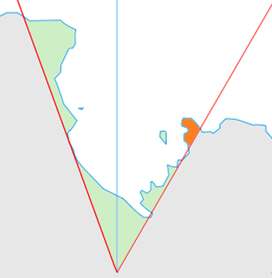 Location of King Edward VII Land (marked in orange) within the Ross Dependency | |
 Location of Butler Glacier in Antarctica | |
| Location | King Edward VII Land |
| Coordinates | 77°24′S 152°42′W / 77.400°S 152.700°W / -77.400; -152.700 |
| Thickness | unknown |
| Terminus | Sulzberger Bay |
| Status | unknown |
Butler Glacier (77°24′S 152°42′W / 77.400°S 152.700°W / -77.400; -152.700Coordinates: 77°24′S 152°42′W / 77.400°S 152.700°W / -77.400; -152.700) is a broad glacier draining the north side of Edward VII Peninsula in the vicinity of Clark Peak, and flowing generally northeastward through the Alexandra Mountains to its terminus in Sulzberger Bay. It was mapped from surveys by the United States Geological Survey and from U.S. Navy air photos (1959–65), and named by the Advisory Committee on Antarctic Names for Lieutenant F.M. Butler, U.S. Navy, expedition navigator in charge of all navigation watch sections on the USS Glacier during the exploration of this area in January 1962.
See also
References

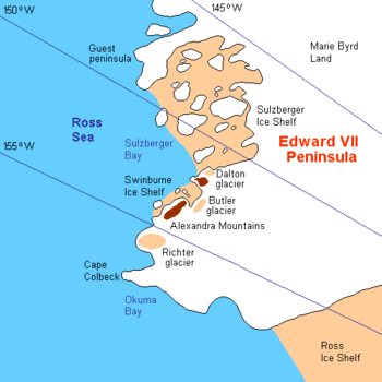
Area map of Butler Glacier
| Types | |||||||
|---|---|---|---|---|---|---|---|
| Anatomy | |||||||
| Processes | |||||||
| Measurements | |||||||
| Volcanic relations | |||||||
| Landforms |
| ||||||
| |||||||
This article is issued from
Wikipedia.
The text is licensed under Creative Commons - Attribution - Sharealike.
Additional terms may apply for the media files.