Saint-Julien, Rhône
| Saint-Julien | |
|---|---|
| Commune | |
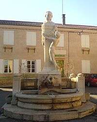 The bust of Claude Bernard in the central square | |
 Saint-Julien Location within Auvergne-Rhône-Alpes region  Saint-Julien | |
| Coordinates: 46°01′38″N 4°39′11″E / 46.0272°N 4.6531°ECoordinates: 46°01′38″N 4°39′11″E / 46.0272°N 4.6531°E | |
| Country | France |
| Region | Auvergne-Rhône-Alpes |
| Department | Rhône |
| Arrondissement | Arrondissement of Villefranche-sur-Saône |
| Canton | Canton of Gleizé |
| Government | |
| • Mayor (2008–2014) | Alain Gaidon |
| Area1 | 6.89 km2 (2.66 sq mi) |
| Population (1999)2 | 768 |
| • Density | 110/km2 (290/sq mi) |
| Time zone | UTC+1 (CET) |
| • Summer (DST) | UTC+2 (CEST) |
| INSEE/Postal code | 69215 /69640 |
| Elevation |
204–502 m (669–1,647 ft) (avg. 250 m or 820 ft) |
|
1 French Land Register data, which excludes lakes, ponds, glaciers > 1 km2 (0.386 sq mi or 247 acres) and river estuaries. 2 Population without double counting: residents of multiple communes (e.g., students and military personnel) only counted once. | |
Saint-Julien is a commune in the Rhône department in eastern France.
See also
References
| Wikimedia Commons has media related to Saint-Julien (Rhône). |
This article is issued from
Wikipedia.
The text is licensed under Creative Commons - Attribution - Sharealike.
Additional terms may apply for the media files.