Brignais
| Brignais | ||
|---|---|---|
| Commune | ||
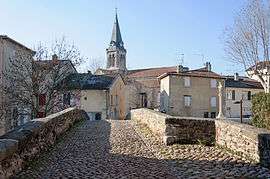 Brignais seen from the old bridge | ||
| ||
 Brignais Location within Auvergne-Rhône-Alpes region  Brignais | ||
| Coordinates: 45°40′29″N 4°45′18″E / 45.6747°N 4.755°ECoordinates: 45°40′29″N 4°45′18″E / 45.6747°N 4.755°E | ||
| Country | France | |
| Region | Auvergne-Rhône-Alpes | |
| Department | Rhône | |
| Arrondissement | Lyon | |
| Canton | Brignais | |
| Intercommunality | Communauté de communes de la Vallée du Garon | |
| Government | ||
| • Mayor (2014-2020) | Paul Minssieux | |
| Area1 | 10.36 km2 (4.00 sq mi) | |
| Population (2012)2 | 11,390 | |
| • Density | 1,100/km2 (2,800/sq mi) | |
| Time zone | UTC+1 (CET) | |
| • Summer (DST) | UTC+2 (CEST) | |
| INSEE/Postal code | 69027 /69530 | |
| Elevation |
203–331 m (666–1,086 ft) (avg. 300 m or 980 ft) | |
|
1 French Land Register data, which excludes lakes, ponds, glaciers > 1 km2 (0.386 sq mi or 247 acres) and river estuaries. 2 Population without double counting: residents of multiple communes (e.g., students and military personnel) only counted once. | ||
.svg.png)
Brignais is a commune of the Rhône department in eastern France.
History
During the Hundred Years War, was the scene of the Battle of Brignais in the year 1362 between the royal army of John II and large companies idle mercenaries, who beat the Kings Knights
List of successive mayors
- 1944 - 1977 Peter Minssieux
- 1977 - 2006 Michel Thiers UDF
- 2006-current Paul Minssieux DVD
Organisations
Brignais belongs to the community of municipalities of the Valley of Garon (CCVG).
Demographics
In 2013, the municipality had 11,429 residents. The evolution of the number of inhabitants is known throughout the population censuses carried out in the town since 1793. From the twenty-first century, censuses of municipalities with more than 10 000 inhabitants are held annually as a result of a sample survey, unlike other cities that have a real census every five
Landmarks
- City Hall between 1901 and 1902:
- The park is a wooded area of three hectares, which sported a former mansion of the eighteenth century, became in 1985 the town hall. The inner courtyard and its old wells are located on the General de Gaulle street.
- The house of the Jamayère.Presbytère
- Villa Giraudière: located south of the town center this was built about 1832 . In 1996, it was acquired by the city of Brignais. The mansion has three floors with an area of 180 m² each. The basement consists of two vaults.
- Hospital Guy de Chauliac
- Guy de Chauliac, illustrious surgeon of the Middle Ages, one of the fathers of modern medicine, practiced in Brignais to 1330. A place bears his name, located in the historic district of the former hospital Brignais. This medieval infrastructure placed outside the walls of the city, formed a quadrangle between Brain Cold streets Giraudière, the Reach and Ro. It housed a pharmacy, a chapel under the patronage of St. Margaret, dependencies rooms, courtyards and gardens for walking sick.
- The old bridge over the vieux.Pont Garon: The building already existed in the Middle Ages, essentially comprises two stone arches of four meters. Before the tests of time and human negligence which deteriorated the monument, the bailiff of Macon, seneschal of Lyon, in 1399 forced the inhabitants of Brignais Vourles and to pay a tax to fix it. This bridge has a top speed bump in like many of his kind at the time. The floor is composed of pebbles "Cat Heads" parapets and walls are covered with granite slabs. It is registered in the inventory of Historic Monuments of France since 1934.
- Maison Renaissance is one of the oldest houses in Brignais (also called Maison Forte) located at 11 Place Gamboni. and built in 1792. It has a spiral staircase behind the door.
- Church of St. Clair: Its first foundations date back to 1859. It was built in place of the Church of the feudal era and the old cemetery, dedicated to St. Clair (590-660), patron of the blind and visually impaired. It is through a public and common fund subscription, this church has been possible. The architect Clair Weaver, born in Sainte-Foy-lès-Lyon (author of the Littré Grand'Côte) and Father Rival, parish priest, govern the construction of the building. The structural work was completed in 1862. The building is both its architecture and its furnishings, a remarkable collection of Gothic style of the thirteenth century, revived the nineteenth day. The woodwork (pulpit, the confessionals and the choir stalls) are the work of sculptor Lyons Aubert. The bell, which dates from 1492, has been listed in the inventory of Historical Monuments November 27, 1905. The organ was built in 1972 by the Jura factors, Hartmann and Deloye to the monastery of the Benedictine nuns of Pradines (near Roanne), and remains in service until 1995.
- Roman aqueduct of Gier: emains located a little further down in the valley in Barret and Gerle
path. Built in the 1st century, the aqueduct brought water to Pilat the capital of Gaul. The people of Lugdunum have long been powered by 75,000 m3 of water brought to them every day 200 km of pipes of four Roman aqueducts. This was the largest hydraulic system after that of Rome.
Gallery
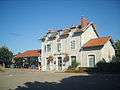 Train station
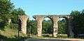 Gier Aqueduct
See also
References
| Wikimedia Commons has media related to Brignais. |